Effect of the 2004 Indian Ocean earthquake on India

Last updated

Countries affected by the 2004 Indian Ocean earthquake Indian Ocean Earthquake2004.png
Countries affected by the 2004 Indian Ocean earthquake

According to official estimates in India, 10,749 people were killed, 5,640 people were missing and thousands of people became homeless when a tsunami triggered by the 2004 Indian Ocean earthquake near the Indonesian island of Sumatra struck the southern coast on 26 December 2004. The earthquake registered 9.1–9.3 Mw and was the largest in five decades. [1] It was followed by strong aftershocks [2] on the Andaman and Nicobar Islands. The death toll of the earthquake was 1,500 people.

Contents

Affected states and regions

A Body is being retrieved after few days of ordeal at Nagapattinam on 2 January 2005 A Body is being retrieved after few days of ordeal at Nagapattinam on January 02, 2005.jpg
A Body is being retrieved after few days of ordeal at Nagapattinam on 2 January 2005
A scene of devastation caused by Tsunami waves in Kalapet village near Pondicherry A scene of devastation caused by Tsunami waves in Kalapet village near Pondicherry.jpg
A scene of devastation caused by Tsunami waves in Kalapet village near Pondicherry
An All Party Meeting to discuss Relief and Rehabilitations Measures of Tsunami Tragedy held in New Delhi on 9 January 2005 An All Party Meeting to discuss Relief and Rehabilitations Measures of Tsunami Tragedy held in New Delhi on January 9, 2005.jpg
An All Party Meeting to discuss Relief and Rehabilitations Measures of Tsunami Tragedy held in New Delhi on 9 January 2005

This disaster affected a total of fourteen regions. [3] The Andaman and Nicobar Islands comprise 572 islands (land masses at low and high tide), of which 38 are inhabited by people from the mainland and indigenous tribes. The islands were just north of the earthquake epicentre, and the tsunami reached a height of 15 metres (49 ft) in the southern Nicobar Islands. The official death toll was 1,310, with about 5,600 missing. The unofficial death toll (including those missing and presumed dead) was estimated at 7,000. This ocean earthquake goes down in history as the deadliest of all time. It took the lives of over 230,000 victims throughout the fourteen regions and wounded more than double this number. [4] The Great Nicobar and Car Nicobar islands were the worst hit among all the islands because of their proximity to the quake and relatively flat terrain. Aftershocks rocked the area, [5] and one-fifth of the population of the Nicobar Islands was reported dead, injured or missing. [6] Chowra Island lost two-thirds of its population of 1,500. Entire islands were submerged, and Trinket Island was divided in two. [7] Communications were cut to the Nancowry group of islands, some of which were submerged. [8]

On Car Nicobar, 111 Indian Air Force personnel and their family members were washed away when the tsunami severely damaged their air base. [9] St. Thomas Cathedral (also known as the John Richardson church after John Richardson, a missionary and member of parliament) was washed away. The church, established in 1930 was one of the oldest and prominent churches in the region. A cricket stadium named after John Richardson and a statue dedicated to him were also washed away.[ citation needed ]

Most of the population of the Andaman Islands are people from the mainland, primarily West Bengal and Tamil Nadu. The natives of the Andaman and Nicobar Islands are endangered tribal groups, such as the Jarawa, Sentinelese, Shompen, Onge and the Great Andamanese. They are anthropologically-significant as some of the world's most primitive tribes. Most have maintained their lifestyle for centuries, and government policy is one of non-interference. Most of the native islanders reportedly survived the tsunami because they lived on higher ground or far from the coast. [10] The Onge (with a 2001 census population of 96), Jarawa (240), Sentinelese (39) and Great Andamanese (43) were reached by survey teams. The Sentinelese, on an island reserve, are hostile to outsiders and shot arrows at helicopters sent to check on them. [11] [12] [13] On the Nicobar Islands the Nicobarese, a tribe with a Southeast Asian heritage (2001 population 28,653), lost about 656 lives with 3,000 missing. Surveys were conducted on the Shompen (2001 census count of 398) located on Great Nicobar island.

India's only active volcano, Barren 1 (on Barren Island 135 km (84 mi) northeast of Port Blair), erupted on 30 December due to increased seismic activity. The population was evacuated, and there were no casualties. Indira Point (6°45’10″N and 93°49’36″E), the southernmost point of the Great Nicobar Island and India itself, subsided 4.25 metres (13.9 ft) in the tsunami and its lighthouse was damaged. [14]

Meteorological and seismic reports

The Indian Meteorological Department warned people in coastal areas to exercise caution due to rough seas and tsunami. [15] The Indian government issued a tsunami alert across India's coastal areas, triggering a panic [16] [17] which required clarifications. [18]

Ex gratia payments

GovernmentEx gratia
Government of India The Prime Minister announced an ex-gratia payment of Rs. 100,000 (one lakh rupees) to the next of kin of each deceased. The payment will be made from the Prime Minister's National Relief Fund.
Government of Tamil Nadu The Chief Minister announced an ex-gratia payment of Rs. 100,000 (one lakh) to the family of each victim. [19]
Government of Kerala Ex gratia payment of Rs. 50,000 to the next kin of those killed; assistance of Rs. 10,000 to the families of the deceased to meet funeral expenses
Union Territory of PuducherryChief Minister N. Rangasamy announced an ex gratia payment of Rs 100,000 (one lakh) to the next of kin of those killed. The administration would also pay an ex gratia Rs 5000 towards funeral expenses. For those injured in the disaster, the administration would provide Rs 5000. A sum of Rs 10,000 would enable the homeless to rebuild their homes. [20]

See also

Related Research Articles

<span class="mw-page-title-main">Andaman Islands</span> Archipelago in the Bay of Bengal

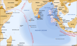
The Andaman Islands are an archipelago, made up of 200 islands, in the northeastern Indian Ocean about 130 km (81 mi) southwest off the coasts of Myanmar's Ayeyarwady Region. Together with the Nicobar Islands to their south, the Andamans serve as a maritime boundary between the Bay of Bengal to the west and the Andaman Sea to the east. Most of the islands are part of the Andaman and Nicobar Islands, a Union Territory of India, while the Coco Islands and Preparis Island are part of the Yangon Region of Myanmar.

<span class="mw-page-title-main">Andaman and Nicobar Islands</span> Union territory of India

The Andaman and Nicobar Islands is a union territory of India. It consists of 836 islands grouped into two island groups: the northern Andaman Islands and the southern Nicobar Islands, separated by a 150 km (93 mi) wide channel. Port Blair is the capital and largest city of the territory, located about 1,190 km (740 mi) from Chennai and 1,255 km (780 mi) from Kolkata in mainland India. The islands are sandwiched between the Bay of Bengal to the west and the Andaman Sea to the east with the northern-most point located 901 km (560 mi) from the mouth of Hooghly river. Indira Point at 6°45’10″N and 93°49’36″E at the southern tip of Great Nicobar is the southernmost point of India.

The Andamanese languages are the languages spoken by the indigenous Andamanese peoples of the Andaman Islands in the Indian Ocean. It contains two known language families, Great Andamanese and Ongan, as well as two presumed but unattested languages, Sentinelese and Jangil.

<span class="mw-page-title-main">Nicobar Islands</span> Island group in the Indian Ocean

The Nicobar Islands are an archipelagic island chain in the eastern Indian Ocean. They are located in Southeast Asia, 150 kilometres (93 mi) northwest of Aceh on Sumatra, and separated from Thailand to the east by the Andaman Sea. Located 1,300 kilometres (810 mi) southeast of the Indian subcontinent, across the Bay of Bengal, they are part of India, as the Nicobar district within the union territory of the Andaman and Nicobar Islands. Together with the Andaman Islands to their north, the Nicobar Islands serve as a maritime boundary between the Bay of Bengal to the west and the Andaman Sea to the east.

<span class="mw-page-title-main">2004 Indian Ocean earthquake and tsunami</span> Earthquake and subsequent tsunami in the Indian Ocean

On 26 December 2004, at 07:58:53 local time (UTC+7), a major earthquake with a magnitude of 9.1–9.3 Mw struck with an epicentre off the west coast of northern Sumatra, Indonesia. The undersea megathrust earthquake, known by the scientific community as the Sumatra–Andaman earthquake, was caused by a rupture along the fault between the Burma Plate and the Indian Plate, and reached a Mercalli intensity up to IX in some areas.

<span class="mw-page-title-main">North Sentinel Island</span> Island in the Andaman Islands

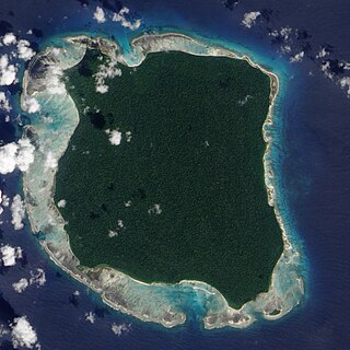
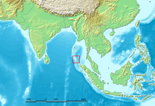
North Sentinel Island is one of the Andaman Islands, an Indian archipelago in the Bay of Bengal which also includes South Sentinel Island. The island is a protected area of India. It is home to the Sentinelese, an indigenous tribe in voluntary isolation who have defended, often by force, their protected isolation from the outside world. The island is about 8 kilometres (5.0 mi) long and 7 kilometres (4.3 mi) wide, and its area is approximately 60 square kilometres (23 sq mi).

<span class="mw-page-title-main">Sentinelese</span> Indigenous insular uncontacted tribe in the Bay of Bengal

The Sentinelese, also known as the Sentineli and the North Sentinel Islanders, are an indigenous people who inhabit North Sentinel Island in the Bay of Bengal in the northeastern Indian Ocean. Designated a particularly vulnerable tribal group and a Scheduled Tribe, they belong to the broader class of Andamanese peoples.

<span class="mw-page-title-main">Andamanese peoples</span> People of Andaman archipelago

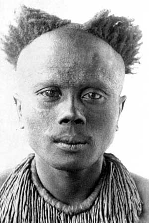
The Andamanese are the various indigenous peoples of the Andaman Islands, part of India's Andaman and Nicobar Islands, the union territory in the southeastern part of the Bay of Bengal. The Andamanese are a designated Scheduled Tribe in India's constitution.

Great Nicobar is the southernmost and largest of the Nicobar Islands of India, north of Sumatra. It is part of India, in the Nicobar district within the union territory of the Andaman and Nicobar Islands.

Trinket Island is one of the 24 islands that make up the Nicobar Islands chain, located in the northeast Indian Ocean between the Bay of Bengal and the Andaman Sea. It is located east of Kamorta Island.

<span class="mw-page-title-main">Great Andamanese</span> Indigenous people in the Andaman Islands

The Great Andamanese are an indigenous people of the Great Andaman archipelago in the Andaman Islands. Historically, the Great Andamanese lived throughout the archipelago, and were divided into ten major tribes. Their distinct but closely related languages comprised the Great Andamanese languages, one of the two identified Andamanese language families.

<span class="mw-page-title-main">Onge</span> Ethnic group of Andaman Islands

The Onge are an Andamanese ethnic group, indigenous to the Andaman Islands in Southeast Asia at the Bay of Bengal, currently administered by India. They are traditionally hunter-gatherers and fishers, but also practice plant cultivation. They are designated as a Scheduled Tribe of India.

<span class="mw-page-title-main">Sentinelese language</span> Presumed language of the Sentinelese of North Sentinel Island

Sentinelese is the undescribed language of the Sentinelese people of North Sentinel Island in the Andaman and Nicobar Islands, India. Due to the lack of contact between the Sentinelese people and the rest of the world, essentially nothing is known of their language or its vitality. The Sentinelese people do not allow outsiders onto the island and are generally hostile towards visitors. Friendly interactions have been rare.

The Jarawas are an indigenous people of the Andaman Islands in India. They live in parts of South Andaman and Middle Andaman Islands, and their present numbers are estimated at between 250–400 individuals. They have largely shunned interaction with outsiders, and many particulars of their society, culture and traditions are poorly understood. Since the 1990s, contacts between Jarawa groups and outsiders grew increasingly frequent. By the 2000s, some Jarawas had become regular visitors at settlements, where they trade, interact with tourists, get medical aid, and even send their children to school.

<span class="mw-page-title-main">Onge language</span> Ongan language of Little Andaman Island

The Onge language, also known as Önge, is one of two known Ongan languages within the Andaman family. It is spoken by the Onge people in Little Andaman Island in India.

<span class="mw-page-title-main">Andaman and Nicobar Police</span> Law enforcement agency in India

The Andaman and Nicobar Police is the law enforcement agency for the Andaman and Nicobar Islands, India. A&N Police comes under the jurisdiction of the Ministry of Home Affairs, Government of India. The A&N Police has a sanctioned strength of 4130 posts of various ranks in Civil Police, Criminal Investigation Department, Immigration Branch, Foreigners Branch, Motor Vehicle Section, Traffic branch, Security Unit, Forensic Science Laboratory, Finger Print Unit, Dog Squad, Special Armed Police, Armed Police, Island Communication, Fire Service Units and India Reserve Battalion.

Shompen Village-B is a village in the Nicobar district of the Andaman and Nicobar Islands, India. It is located in the Great Nicobar tehsil.

Shompen Village-A is a village in the Nicobar district of Andaman and Nicobar Islands, India. It is located in the Great Nicobar tehsil.

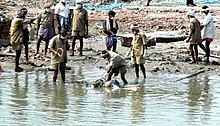
Madhumala Chattopadhyay is an Indian anthropologist who specializes in the Indigenous peoples of the Andaman and Nicobar Islands. In 1991, Chattopadhyay and her colleagues were the first outsiders to make peaceful contact with the Sentinelese people.

The Andaman and Nicobar Islands is an archipelago of 572 islands of which 37 are inhabited. It is a union territory of India.

References

  1. "Magnitude 9.1 – OFF THE WEST COAST OF NORTHERN SUMATRA". U.S. Geological Survey. Archived from the original on 1 September 2012. Retrieved 26 August 2012.
  2. Archived 3 January 2005 at the Wayback Machine
  3. Taylor, Alan (26 December 2014). "Ten Years Since the 2004 Indian Ocean Tsunami" . Retrieved 1 February 2016.
  4. Osbourne, Hannah (22 December 2014). "2004 Indian Ocean earthquake and tsunami: Facts about the Boxing Day disaster" . Retrieved 1 February 2016.
  5. Archived 6 March 2005 at the Wayback Machine
  6. "Asia toll touches 68,000; 12,500 dead in India". The Times of India. 29 December 2004. Retrieved 21 May 2013.
  7. Archived 2 January 2005 at the Wayback Machine
  8. "7000 still missing: Mukherjee". Rediff.com. 30 December 2004. Retrieved 21 May 2013.
  9. Archived 6 March 2005 at the Wayback Machine
  10. "National : All primitive tribes safe". The Hindu . 31 December 2004. Archived from the original on 3 January 2005. Retrieved 21 May 2013.
  11. [ dead link ]
  12. "Remote Indian Islands See Tsunami Destruction". NPR. 29 December 2004. Retrieved 21 May 2013.
  13. Archived 15 January 2005 at the Wayback Machine
  14. "Indira Point falls off map | India News – Times of India". The Times of India .
  15. Archived 28 December 2009 at the Wayback Machine
  16. "Panic in TN town after tsunami alert". Us.rediff.com. 30 December 2004. Retrieved 27 November 2013.
  17. "Breaking News, Top News & Latest News Headlines". Reuters. 9 February 2009. Archived from the original on 28 June 2005. Retrieved 27 November 2013.
  18. Archived 29 November 2005 at the Wayback Machine
  19. [usurped]
  20. Archived 8 May 2005 at the Wayback Machine