El Dorado Hills, California

Last updated

El Dorado Hills
El Dorado Hills 616 - panoramio (cropped).jpg
El Dorado Hills Town Center
El Dorado County California Incorporated and Unincorporated areas El Dorado Hills Highlighted.svg
Location in El Dorado County and the state of California
Usa edcp location map.svg
Red pog.svg
El Dorado Hills
Location in the United States
Coordinates: 38°41′09″N121°04′56″W / 38.68583°N 121.08222°W / 38.68583; -121.08222
Country Flag of the United States.svg  United States
State Flag of California.svg  California
County El Dorado
Area
[1]
  Total48.606 sq mi (125.888 km2)
  Land48.454 sq mi (125.494 km2)
  Water0.152 sq mi (0.394 km2)  0.31%
Elevation
[2]
768 ft (234 m)
Population
  Total50,547
  Density1,000/sq mi (400/km2)
Time zone UTC-8 (Pacific)
  Summer (DST) UTC-7 (PDT)
ZIP code
95762
Area codes 916, 279, 530
FIPS code 06-21880
GNIS feature IDs 1867020, 2408055

El Dorado Hills (El Dorado, Spanish for "The Golden") is an unincorporated town and census-designated place in El Dorado County, California. Located in the Greater Sacramento region of Northern California, it had a population of 50,547 at the 2020 census, up from 42,108 at the 2010 census. [3]

Contents

History

Restaurants in the town center Fair294 (17315964489).jpg
Restaurants in the town center
Shops on Latrobe Road Latrobe Rd. 679 - panoramio (cropped).jpg
Shops on Latrobe Road

During the California Gold Rush, gold was washed down the South Fork of the American River, into areas now in El Dorado Hills and Folsom, but farming and ranching supplanted mining or panning for gold. Portions of two Pony Express routes in this area from 1860 to 1861 remain as modern El Dorado Hills roads. [4]

The modern history of El Dorado Hills dates back to the early 1960s when original developer Allan Lindsey began its development as a master-planned community. The original master plan, prepared by architect Victor Gruen, covered the area generally north of U.S. Highway 50, and part of the area south of US 50 now considered to be part of the community. El Dorado Hills was envisioned as a large-scale master-planned community that would be completely planned from its inception as a group of residential "villages". Other land uses in the master plan included a business park, 18-hole golf course, community parks, schools, a community shopping center, and small commercial centers in each village. The master plan[ citation needed ] emphasized open space between villages and the opportunity for outdoor recreation.

Between the late 1960s and mid-1990s, growth occurred at a moderate pace as new families relocated from Sacramento, Southern California and the Bay Area. This growth consisted primarily of residential housing, as retail developments were limited to two shopping centers on the corners Green Valley & Francisco and El Dorado Hills Boulevard & US 50. Each neighborhood created during this time period was given a name and referred to as a "village" by local inhabitants. The original villages of El Dorado Hills include Ridgeview, Park, Saint Andrews, Crown, and Governors. In the 1980s and 1990s, the major part of Lake Hills Estates north of Green Valley Road was reorganized into Lake Forest Village, [5] containing the neighborhoods of Waterford, The Summit, [6] Green Valley Hills, Winterhaven, Marina Woods and Windsor Point. Additional villages that have developed subsequently include Fairchild, Sterlingshire, Highland Hills, Highland View, Bridlewood, Hills of El Dorado, Woodridge, Laurel Oaks and the master-planned community of Serrano.

The El Dorado Hills Town Center, just south of US 50, is a mixed-use project developed by The Mansour Company. Occupying 100 acres (40 ha) of land and, at completion, one million square feet (93,000 m2) of buildings, it is the center of town and of the region. [7]

Geography

Steven Young Amphitheatre El Dorado Hills 618 - panoramio (cropped).jpg
Steven Young Amphitheatre

El Dorado Hills (EDH), as defined by the 2010 census-designated place (CDP), is at the western border of El Dorado County, between the City of Folsom and the unincorporated community of Cameron Park. The northern limits of the CDP are Folsom Lake and the South Fork of the American River, where river rafters use Skunk Hollow and Salmon Falls as takeout landings. West of Latrobe Road, the south edge of the CDP follows railroad tracks formerly used by the Southern Pacific between the cities of Folsom and Placerville. East of Latrobe Road the south edge follows topography running roughly east–west.

The 2010 CDP has a land area of 48.606 square miles (125.89 km2), more than double the size of its boundaries in 2000 CDP, which was 17.9 square miles (46 km2).

The subsurface environment of El Dorado Hills is relatively free of groundwater and soil contamination, based upon an areawide analysis of the potential for pesticide contamination and evaluation of underground storage tanks.(Earth Metrics, 1989)

Climate

According to the Köppen climate classification, El Dorado Hills has a hot-summer Mediterranean climate (abbreviated Csa).

Climate data for El Dorado Hills, 1991–2020 simulated normals (682 ft elevation)
MonthJanFebMarAprMayJunJulAugSepOctNovDecYear
Average high °F (°C)55.6
(13.1)
59.9
(15.5)
64.4
(18.0)
70.0
(21.1)
78.4
(25.8)
87.4
(30.8)
94.1
(34.5)
93.4
(34.1)
88.3
(31.3)
77.9
(25.5)
64.4
(18.0)
55.8
(13.2)
74.1
(23.4)
Daily mean °F (°C)47.3
(8.5)
50.4
(10.2)
54.0
(12.2)
57.7
(14.3)
64.6
(18.1)
71.8
(22.1)
77.4
(25.2)
76.6
(24.8)
72.7
(22.6)
64.2
(17.9)
53.8
(12.1)
47.1
(8.4)
61.5
(16.4)
Average low °F (°C)39.0
(3.9)
40.8
(4.9)
43.3
(6.3)
45.7
(7.6)
50.7
(10.4)
56.1
(13.4)
60.6
(15.9)
60.1
(15.6)
57.0
(13.9)
50.5
(10.3)
43.2
(6.2)
38.3
(3.5)
48.8
(9.3)
Average precipitation inches (mm)4.71
(119.62)
4.86
(123.38)
4.15
(105.35)
2.35
(59.68)
1.40
(35.56)
0.36
(9.14)
0.00
(0.00)
0.04
(0.98)
0.15
(3.88)
1.14
(28.88)
2.58
(65.46)
4.79
(121.69)
26.53
(673.62)
Average dew point °F (°C)40.5
(4.7)
41.4
(5.2)
43.3
(6.3)
44.4
(6.9)
47.7
(8.7)
50.4
(10.2)
52.0
(11.1)
50.9
(10.5)
48.0
(8.9)
44.2
(6.8)
42.6
(5.9)
39.7
(4.3)
45.4
(7.5)
Source: PRISM Climate Group [8]

Demographics

Historical population
CensusPop.Note
2000 18,016
2010 42,108133.7%
2020 50,54720.0%
U.S. Decennial Census [9]

2020

As of the 2020 United States Census, [10] El Dorado Hills had a population of 50,547, with 16,212 households. Its total population's racial makeup was 39,636 (84.1%) White, 1,209 (2.6%) Black or African-American, 815 (1.7%) American Indian and Alaska Native, 6,964 (14.8%) Asian, 404 (0.9%) Pacific Islander, 1,419 (3.2%) from some other race, with 3,158 (6.7%) of two or more races. 3,820 (8.1%) people of any race were Hispanic or Latino. While there were other small changes in racial makeup, this census saw the greatest increase in the proportion of Asian-identified people (+ 6.3%) in comparison to the 2010 census.

2010

The 2010 United States Census [11] reported that El Dorado Hills had a population of 42,108. The population density was 866.3 inhabitants per square mile (334.5/km2). The racial makeup of El Dorado Hills was 35,089 (83.3%) White, 615 (1.5%) African American, 196 (0.5%) Native American, 3,563 (8.5%) Asian, 71 (0.2%) Pacific Islander, 681 (1.6%) from other races, and 1,893 (4.5%) from two or more races. Hispanic or Latino of any race were 3,802 persons (9.0%).

The Census reported that 42,092 people (100% of the population) lived in households, 16 (0%) lived in non-institutionalized group quarters, and 0 (0%) were institutionalized.

There were 14,368 households, out of which 6,516 (45.4%) had children under the age of 18 living in them, 10,503 (73.1%) were opposite-sex married couples living together, 1,070 (7.4%) had a female householder with no husband present, 490 (3.4%) had a male householder with no wife present. There were 464 (3.2%) unmarried opposite-sex partnerships, and 85 (0.6%) same-sex married couples or partnerships. 1,798 households (12.5%) were made up of individuals, and 670 (4.7%) had someone living alone who was 65 years of age or older. The average household size was 2.93. There were 12,063 families (84.0% of all households); the average family size was 3.20.

The population was spread out, with 12,430 people (29.5%) under the age of 18, 2,511 people (6.0%) aged 18 to 24, 9,455 people (22.5%) aged 25 to 44, 13,232 people (31.4%) aged 45 to 64, and 4,480 people (10.6%) who were 65 years of age or older. The median age was 40.6 years. For every 100 females, there were 97.5 males. For every 100 females age 18 and over, there were 94.7 males.

There were 14,994 housing units at an average density of 308.5 per square mile (119.1/km2), of which 14,368 were occupied, of which 12,169 (84.7%) were owner-occupied, and 2,199 (15.3%) were occupied by renters. The homeowner vacancy rate was 1.7%; the rental vacancy rate was 4.1%. 35,755 people (84.9% of the population) lived in owner-occupied housing units and 6,337 people (15.0%) lived in rental housing units.

2000

As of the census [12] of 2000, there were 18,016 people, 5,896 households, and 5,206 families residing in the CDP. The population density was 1,006.3 inhabitants per square mile (388.5/km2). There were 6,071 housing units at an average density of 339.1 per square mile (130.9/km2). SACOG's estimate for December, 2003 was 9,713 dwelling units.

The Census Bureaus's assessment of racial makeup of the CDP was 90.11% White, 0.77% Black or African American, 0.46% Native American, 4.11% Asian, 0.17% Pacific Islander, 1.37% from other races, and 3.01% from two or more races. 4.97% of the population were Hispanic or Latino of any race.

There were 5,896 households, out of which 50.7% had children under the age of 18 living with them, 79.5% were married couples living together, 6.5% had a female householder with no husband present, and 11.7% were non-families. 9.4% of all households were made up of individuals, and 2.7% had someone living alone who was 65 years of age or older. The average household size was 3.06 and the average family size was 3.26.

In the CDP, the population distribution was 33.2% under the age of 18, 4.5% from 18 to 24, 29.4% from 25 to 44, 25.6% from 45 to 64, and 7.3% who were 65 years of age or older. The median age was 38 years. For every 100 females, there were 99.3 males. For every 100 females age 18 and over, there were 96.0 males.

According to a 2007 estimate, the median income for a household in the CDP was $113,927, and the median income for a family was $125,230. [13] Males had a median income of $75,369 versus $45,978 for females. The per capita income for the CDP was $40,239. 1.7% of the population and 1.5% of families were below the poverty line. Out of the total population, 1.5% of those under the age of 18 and 2.2% of those 65 and older were living below the poverty line.

El Dorado Hills is among the highest income communities of its size range in the nation, though this is seldom noted because of its unincorporated status. El Dorado Hills would rank 3rd highest by median household income in a list of places with population greater than 40,000, following only Potomac, Maryland and Danville, California.

Total population within the El Dorado Hills Community Services District (CSD) was certified as 35,276 in January, 2006 by the California State Department of Finance. The El Dorado Hills Fire Department reported a population of 42,078 in its service area at the end of 2007. The Fire Department's district covers a larger geographic area than the CSD and is more nearly equivalent to the El Dorado County definition of the El Dorado Hills Community Region.

Government

In the California State Legislature, El Dorado Hills is in the 1st Senate District , represented by Republican Brian Dahle, [14] and the 6th Assembly District , represented by Democrat Kevin McCarty. [15]

In the United States House of Representatives, El Dorado Hills is in California's 5th Congressional District represented by Republican Tom McClintock. [16]

As an unincorporated area, the local government of El Dorado Hills is that of El Dorado County. Two supervisorial districts include parts of El Dorado Hills. District 1 is represented by John Hidahl and District 2 by George Turnboo. [17]

A number of services are provided by other local agencies. These include the El Dorado Hills Community Services District (CSD), [18] the Rolling Hills Community Services District (CSD), [19] the Marble Mountain Community Services District, the El Dorado Hills County Water District (fire department), [20] and the El Dorado Irrigation District. [21]

Notable people

Related Research Articles

<span class="mw-page-title-main">El Dorado County, California</span> County in California, United States

El Dorado County, officially the County of El Dorado, is a county located in the U.S. state of California. As of the 2020 census, the population was 191,185. The county seat is Placerville. The county is part of the Sacramento-Roseville-Arden-Arcade, CA Metropolitan Statistical Area. It is located entirely in the Sierra Nevada, from the historic Gold Country in the western foothills to the High Sierra in the east. El Dorado County's population has grown as Greater Sacramento has expanded into the region. Where the county line crosses US 50 at Clarksville, the distance to Sacramento is 15 miles. In the county's high altitude eastern end at Lake Tahoe, environmental awareness and environmental protection initiatives have grown along with the population since the 1960 Winter Olympics, hosted at the former Squaw Valley Ski Resort in neighboring Placer County.

<span class="mw-page-title-main">Kirkwood, California</span> Place in California, United States

Kirkwood is an unincorporated community in Alpine and Amador counties, California, United States. Kirkwood's main attraction is the Kirkwood Mountain Resort. The town is accessible by State Route 88. Kirkwood is within the Eldorado National Forest. The population was 158 at the 2010 census. For statistical purposes, the United States Census Bureau has defined Kirkwood as a census-designated place (CDP).

<span class="mw-page-title-main">Discovery Bay, California</span> Census-designated place in California, United States

Discovery Bay is a census-designated place (CDP) in eastern Contra Costa County, California in the United States, about 60 miles (97 km) from San Francisco. It is located in the San Francisco Bay Area. As of 2020, its population was 15,358, a 15% percent gain from 13,352 at the 2010 census.

<span class="mw-page-title-main">East Richmond Heights, California</span> Unincorporated community in California, United States

East Richmond Heights is an unincorporated community and census-designated place (CDP) in western Contra Costa County, California, United States. Its population was 3,280 at the 2010 census.

<span class="mw-page-title-main">Cameron Park, California</span> CDP in California, United States

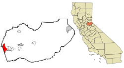
Cameron Park is a census-designated place (CDP) in El Dorado County, California, United States and is part of the Greater Sacramento Area. The population was 19,171 in the 2020 census, up from 18,228 in 2010. Cameron Park is a community located in the Northern California Gold Country of the Sierra Nevada foothills, approximately 30 miles (50 km) east of Sacramento and 70 miles (110 km) west of South Lake Tahoe.

<span class="mw-page-title-main">Winterhaven, California</span> Census-designated place in California, United States

Winterhaven is a census-designated place (CDP) in Imperial County, California. Winterhaven is 6.5 miles (10 km) east of Pilot Knob, The population was 394 at the 2010 census, down from 529 at the 2000 census. It is part of the El Centro, CA Metropolitan Area. North of Interstate 8 and bordering Yuma, Arizona, the town is partly in the Fort Yuma Indian Reservation. The Colorado River marks the town's southern border.

<span class="mw-page-title-main">Avocado Heights, California</span> Census-designated place in California, United States

Avocado Heights is an unincorporated census-designated place (CDP) in the San Gabriel Valley of Los Angeles County, California, United States. It is almost entirely surrounded by the City of Industry with only a small strip of unincorporated Los Angeles County separating it from South El Monte. It is in close proximity to both the Pomona (SR-60) and San Gabriel (I-605) freeways. To the west is the San Gabriel River and the California Country Club. Avocado Heights is approximately 15 miles (24 km) from the downtown Los Angeles Civic Center. The population was 15,411 at the 2010 census, up from 15,148 at the 2000 census.

<span class="mw-page-title-main">Gold River, California</span> Census-designated place in California, United States

Gold River is a census-designated place (CDP) in Sacramento County, California. The population was 7,812 at the 2010 census, down from 8,023 at the 2000 census. Gold River is part of the Sacramento–Arden-Arcade–Roseville Metropolitan Statistical Area. With a median family income of $141,399 according to U.S Census Bureau in 2021, Gold River is the highest-income place in Sacramento County.

<span class="mw-page-title-main">La Riviera, California</span> Census-designated place in California, United States

La Riviera is a census-designated place (CDP) in Sacramento County, California, United States. It is part of the Sacramento–Arden-Arcade–Roseville Metropolitan Statistical Area. The population was 10,802 at the 2010 census, up from 10,273 at the 2000 census. La Riviera is a primarily residential neighborhood located between the American River on the North side and Highway 50 on the southern border.

<span class="mw-page-title-main">Orangevale, California</span> Census-designated place in California, United States

Orangevale is a census-designated place (CDP) in Sacramento County, California, United States. It is part of the Sacramento–Arden-Arcade–Roseville Metropolitan Statistical Area. The population was 33,960 at the 2010 census, up from 26,705 at the 2000 census. It is located approximately 25 miles (40 km) northeast of Sacramento. The community is known for its rolling hills that offer the best views of the Sierra Nevada mountain range, its foothills, and a rural environment in the middle of a growing metropolitan area. Some residential properties in the area are zoned to accommodate horses and orchards. It has a ZIP Code of 95662.

<span class="mw-page-title-main">Rancho Murieta, California</span> Census-designated place in California, United States

Rancho Murieta is a census-designated place (CDP) and guard-gated community in Sacramento County, California, United States. It is part of the Sacramento–Arden-Arcade–Roseville Metropolitan Statistical Area. The population was 5,488 at the 2010 census, up from 4,193 at the 2000 census. It is located in the foothills of the Sierra Nevada range, about 25 miles (40 km) east of Sacramento.

<span class="mw-page-title-main">Rosemont, California</span> Census-designated place in California, United States

Rosemont is a census-designated place (CDP) in Sacramento County, California, United States. It is part of the Sacramento–Arden-Arcade–Roseville metropolitan area. The population rose to 23,510 at the 2020 census. It was 22,681 at the 2010 census, down from 22,904 at the 2000 census.

<span class="mw-page-title-main">Big River, California</span> Census-designated place in California, United States

Big River is a census-designated place (CDP) in San Bernardino County, California, United States. The population was 1,327 at the 2010 census, up from 1,266 at the 2000 census.

<span class="mw-page-title-main">Granite Hills, California</span> Census-designated place in California, United States

Granite Hills is a census-designated place in San Diego County, California. The name is also applied to a neighborhood within the city limits of El Cajon in the eastern part of that city. The population of the CDP, which does not include the people living within the city of El Cajon, was 3,035 at the 2010 census, down from 3,246 at the 2000 census.

<span class="mw-page-title-main">Vandenberg Village, California</span> Census-designated place in California, United States

Vandenberg Village is a census-designated place (CDP) in the unincorporated area of Santa Barbara County, California, United States. The population was 6,497 at the 2010 census, up from 5,802 at the 2000 census.

<span class="mw-page-title-main">El Verano, California</span> Census-designated place in California, United States

El Verano is a census-designated place (CDP) in Sonoma Valley, Sonoma County, California, United States. The population was 4,123 at the 2010 census, falling to 3,867 at the 2020 census.

<span class="mw-page-title-main">Galisteo, New Mexico</span> CDP in New Mexico, United States

Galisteo is a census-designated place (CDP) in Santa Fe County, New Mexico, United States. It is part of the Santa Fe, New Mexico Metropolitan Statistical Area. The population was 253 at the 2010 census.

<span class="mw-page-title-main">Glorieta, New Mexico</span> CDP in New Mexico, United States

Glorieta is a census-designated place (CDP) in Santa Fe County, New Mexico, United States. It is part of the Albuquerque–Santa Fe–Las Vegas combined statistical area. The population was 430 at the 2010 census. The community is located in the southern Sangre de Cristo Mountains, along Interstate 25 on the east side of Glorieta Pass.

<span class="mw-page-title-main">Lamy, New Mexico</span> CDP in New Mexico, United States

Lamy is a census-designated place (CDP) in Santa Fe County, New Mexico, United States, 18 miles (29 km) south of the city of Santa Fe. The community was named for Archbishop Jean-Baptiste Lamy, and lies within the Bishop John Lamy Spanish Land Grant, which dates back to the eighteenth century.

<span class="mw-page-title-main">Rossmoor, California</span> Census-designated place in California, United States

Rossmoor is a planned census-designated place located in Orange County, California. As of the 2020 census, the CDP had a total population of 10,625 up from the 2010 census population of 10,244. The gated Leisure World retirement community in the city of Seal Beach is to the south of Rossmoor, Los Alamitos is to the east and north, and Long Beach is to the west. The community of Rossmoor has two shopping centers within its boundaries, but only one—the Rossmoor Village Square, is now within the political boundaries of Rossmoor. A larger shopping center, the Rossmoor Business Center, was annexed, despite many protests, by the City of Seal Beach in 1967. The Center has been remodeled several times and was renamed the Shops at Rossmoor in the early 2000s.

References

  1. "2010 Census U.S. Gazetteer Files – Places – California". United States Census Bureau.
  2. "El Dorado Hills". Geographic Names Information System . United States Geological Survey, United States Department of the Interior . Retrieved February 8, 2015.
  3. "Census Quickfacts: CA – El Dorado Hills CDP". U.S. Census Bureau. Retrieved April 12, 2022.
  4. "Placerville - Overland Pony Express Route in California (No. 701 California Historical Landmark) | Sierra Nevada Geotourism". sierranevadageotourism.org. Retrieved September 24, 2020.
  5. "Lake Forest Owners Association | El Dorado Hills, California". Lakeforestmaster.org. Archived from the original on March 30, 2017. Retrieved March 29, 2017.
  6. "The Summit". Thesummitedh.org. August 6, 2011. Retrieved March 29, 2017.
  7. "El Dorado Hills Town Center". Archived from the original on January 31, 2013. Retrieved January 17, 2013.
  8. "PRISM Climate Group at Oregon State University". Northwest Alliance for Computational Science & Engineering (NACSE), based at Oregon State University. Retrieved March 16, 2023.
  9. "Census of Population and Housing". Census.gov. Retrieved June 4, 2016.
  10. "U.S. Census Bureau QuickFacts: El Dorado Hills CDP, California". www.census.gov. Retrieved May 4, 2022.
  11. "2010 Census Interactive Population Search: CA – El Dorado Hills CDP". U.S. Census Bureau. Archived from the original on July 15, 2014. Retrieved July 12, 2014.
  12. "U.S. Census website". United States Census Bureau . Retrieved January 31, 2008.
  13. "American FactFinder - Community Facts". Factfinder.census.gov. October 5, 2010. Archived from the original on February 11, 2020. Retrieved March 29, 2017.
  14. "Senators". State of California. Retrieved April 5, 2013.
  15. "Members Assembly". State of California. Retrieved April 5, 2013.
  16. “About the District.” Congressman Tom McClintock, 4 Dec. 2012, mcclintock.house.gov/about/our-district . Accessed 30 Mar. 2023. ‌
  17. "BOS Main Info". County of El Dorado. Retrieved November 17, 2018.
  18. "El Dorado Hills Community Services District - CSD - Recreation, Parks, Events, El Dorado Hills Community Services". Edhcsd.org. February 24, 2017. Retrieved March 29, 2017.
  19. "Rolling Hills Community Services District – Rolling Hills Community Services District". Rollinghillscsd.org. Retrieved March 29, 2017.
  20. "HOME – El Dorado Hills Fire Department". Edhfire.com. Retrieved March 29, 2017.
  21. "El Dorado Irrigation District : Home". Eid.org. September 20, 2011. Retrieved March 29, 2017.

Bibliography