West Sacramento, California

Last updated

West Sacramento, California
City of West Sacramento
Sacramento-river-bank-pyramid-20.4.jpg
The Ziggurat Building on the Sacramento River in West Sacramento
Nickname: 
West Sac
Yolo County California Incorporated and Unincorporated areas West Sacramento Highlighted.svg
Location in Yolo County and the state of California
USA California location map.svg
Red pog.svg
West Sacramento
Location in the State of California
Usa edcp location map.svg
Red pog.svg
West Sacramento
Location in the contiguous United States
Coordinates: 38°34′50″N121°31′49″W / 38.58056°N 121.53028°W / 38.58056; -121.53028
Country United States
State California
County Yolo
Incorporated January 1, 1987 [1]
Government
   Mayor Martha Guerrero [2]
  City Council [3] Quirina Orozco [4]

Norma Alcala

Chris Ledesma
   City manager Aaron Laurel
   State leg. Sen. Bill Dodd (D)
Asm. Cecilia Aguiar-Curry (D)
   U.S. Congress Doris Matsui (D) [5]
Area
[6]
  Total22.80 sq mi (59.05 km2)
  Land21.47 sq mi (55.61 km2)
  Water1.33 sq mi (3.45 km2)  6.22%
Elevation
[7]
20 ft (6 m)
Population
 (2010) [8]
  Total48,744
  Estimate 
(2019) [9]
53,519
  Density2,492.73/sq mi (962.46/km2)
Time zone UTC-8 (Pacific)
  Summer (DST) UTC-7 (PDT)
ZIP code
95691, 95605
Area code(s) 916 and 279
FIPS code 06-84816
GNIS feature IDs 1660149, 2412228
Website www.cityofwestsacramento.org

West Sacramento (also known as West Sac) is a city in Yolo County, California, United States. The city is separated from Sacramento by the Sacramento River, which also separates Sacramento and Yolo counties. It is a fast-growing community; the population was 53,915 at the 2020 census, up from 48,744 at the 2010 census. The traditional industrial center of the region since the Gold Rush era, West Sacramento is home to a diverse economy and is one of the area's top four employment centers.

Contents

The United States Conference of Mayors named West Sacramento as the Most Livable City in America in 2014 in the category of cities with fewer than 100,000 residents. [10]

West Sacramento is part of the Sacramento–Arden Arcade–Roseville Metropolitan Statistical Area which has a population (2000) of approximately 1,796,857 (July 1, 2016 estimate placed the population at 2,296,418). [11] Major industries to the region include agriculture, government, and transportation.

History

Gold Rush era

In 1844, John Schwartz, a Flemish traveler, was the first Euro-American to permanently settle in the area of West Sacramento, which at that time was part of Mexico. He built a shack on the west bank of the Sacramento River six miles (10 km) south of its connection with the American River. John, with the help of his brother George, founded a salmon fishery along the river. In addition to the fishery, they also found the soil to be fertile and began farming and raising livestock. The announcement of the discovery of gold at Sutter's Mill in 1848 brought a multitude of miners to the region. This also coincided with the end of the Mexican–American War.

In 1846, a man named James McDowell bought 600 acres (240 ha) from John Schwartz. With his wife, Margaret, and their three daughters, McDowell settled in the area we know today as Broderick. The McDowell family experienced first-hand the violence that the gold rush era brought with it. In May 1849, James McDowell was shot and killed in a barroom argument that he had supposedly started. With the loss of the sole supporter of the McDowell family, Margaret needed to find a way to provide for her family.

In October 1849, Margaret hired a land surveyor to map out 160 acres (65 ha), which was then divided into forty one blocks. She sold individual lots within this platted area which she named the "Town of Washington". The first lot was sold to August W. Kaye for $500. During its first ten years, the rural Town of Washington went through a significant increase in business development and shipping activity. One of the first businesses to be established in the town was the California Steam Navigation Company, which was attracted to the area in 1859 by how close the Sacramento River is to it. Other businesses in early Washington included hotels, saloons, and restaurants catering to the needs of people passing through. Many of the travelers making the treacherous journey through the marshlands on their way to Sacramento were appreciative of the rest stop at the Town of Washington.

While Sacramento began to urbanize on the other side of the river, early West Sacramento found its hand at agricultural development. Salmon, sturgeon, catfish, eel, crayfish, and clams proved to be lucrative in this region as fisherman soon found. The river settlement was flourishing, stocking fish markets not only in Sacramento, but in San Francisco as well. In addition, the rich soil of the valley produced abundant crops of corn, melons, cucumbers, and sweet potatoes. The dairy industry also established roots in West Sacramento around this time.

One of the area's most well known dairy farmers was Mike Bryte. Bryte came to California in 1849 to try his hand at gold mining. He didn't make a fortune in gold, but was able to purchase a dairy farm with his findings. When the California Steam Navigation Company came to Washington, Bryte used the steamships to carry his dairy products to various markets within the region. Profits from this allowed Bryte to expand his holdings. Bryte was able to own several thousand acres of land in the area to farm on, as well as raise his many livestock on. Mike Bryte's influence in the community was marked by his election to the Yolo County Board of Supervisors and later as sheriff. During the 20th century, Mike Bryte's property was divided and became known as the community of Bryte. [12]

Mission Motel on Route 99 in West Sacramento (c.1930s). Mission Motel, 1 1-2 M. West of State Capitol, Highways 40 and 99 W. West Sacramento, Calif (81523).jpg
Mission Motel on Route 99 in West Sacramento (c.1930s).

Developing a city

In time, the region began to develop. The Town of Washington was renamed Broderick in honor of U. S. Senator David C. Broderick. After 1900, the three communities known as Bryte, Broderick, and West Sacramento were cumulatively known as "East Yolo". [13]

From 1900 to 1920, the population of this area doubled from 1,398 to 2,638. The West Sacramento post office opened in 1915. [13]

These communities officially incorporated as the City of West Sacramento in 1987.

Port of West Sacramento, located in the city. Port of Sacramento.jpg
Port of West Sacramento, located in the city.

Port of West Sacramento

In June 1963, the Port of Sacramento was opened to deep sea traffic with the completion of the Sacramento Deep Water Ship Channel. The project had been authorized by Congress in 1946 and construction commenced in 1949 on the west side of the river. It has since been renamed The Port of West Sacramento. The Port's main imports include cement and exports include rice. [14]

Aerial view of West Sacramento and Sacramento River. West Sacramento, California.jpg
Aerial view of West Sacramento and Sacramento River.

Geography

West Sacramento is located at 38°34′50″N121°31′49″W / 38.58056°N 121.53028°W / 38.58056; -121.53028 . [15]

According to the United States Census Bureau, the city has a total area of 22.8 square miles (59 km2), of which, 21.4 square miles (55 km2) of it is land and 1.4 square miles (3.6 km2) of it (6.22%) is water.

West Sacramento, which lies in Yolo County, is separated from the city of Sacramento and Sacramento County by the Sacramento River. West Sacramento, incorporated in 1987, consists of three communities that were originally distinct towns, Broderick, Bryte, and West Sacramento (originally just the community north of the port canal and south of the railroads), as well as the Southport area.

Southport, which comprises about half of the city's land area, originally consisted of rural homesteads and small neighborhoods in Arlington Oaks and Linden, but now has a considerable population that resulted from housing booms in the early 1990s and the early 2000s, adding new neighborhoods in Bridgeway, Gateway, River Ranch, and Newport.

Climate

Locals enjoy fishing in the Sacramento Deep Water Ship Channel under the Daniel C. Palamidessi Bridge (Industrial Blvd.) Under the Daniel C. Palamidessi Bridge.jpg
Locals enjoy fishing in the Sacramento Deep Water Ship Channel under the Daniel C. Palamidessi Bridge (Industrial Blvd.)
The Clarksburg Branch Line Trail follows an old railway branch in West Sac. Clarksburg Branch Line Trail.jpg
The Clarksburg Branch Line Trail follows an old railway branch in West Sac.

According to the Köppen Climate Classification system, West Sacramento has a hot-summer Mediterranean climate, abbreviated "Csa" on climate maps. [16]

Climate data for West Sacramento, California
MonthJanFebMarAprMayJunJulAugSepOctNovDecYear
Record high °F (°C)74
(23)
79
(26)
86
(30)
95
(35)
108
(42)
113
(45)
112
(44)
110
(43)
111
(44)
101
(38)
86
(30)
78
(26)
113
(45)
Mean daily maximum °F (°C)54
(12)
61
(16)
66
(19)
73
(23)
81
(27)
88
(31)
93
(34)
92
(33)
88
(31)
79
(26)
64
(18)
55
(13)
74
(23)
Mean daily minimum °F (°C)40
(4)
43
(6)
45
(7)
48
(9)
52
(11)
57
(14)
59
(15)
59
(15)
57
(14)
51
(11)
44
(7)
39
(4)
49
(9)
Record low °F (°C)19
(−7)
21
(−6)
24
(−4)
30
(−1)
34
(1)
37
(3)
43
(6)
40
(4)
37
(3)
27
(−3)
24
(−4)
20
(−7)
19
(−7)
Average precipitation inches (mm)4.06
(103)
3.66
(93)
2.98
(76)
1.08
(27)
0.55
(14)
0.18
(4.6)
0.05
(1.3)
0.06
(1.5)
0.35
(8.9)
0.96
(24)
2.38
(60)
2.66
(68)
18.97
(482)
Source: [17]

Businesses

TV stations

West Sacramento is home to Sacramento-area CBS television station KOVR and The CW station KMAX-TV. Both stations, owned and operated by CBS, are housed on KOVR Drive.

Newspapers

The News-Ledger and the West Sacramento Sun are weekly, printed newspapers that serve West Sacramento. The Sacramento Bee has the largest circulation and readership in the city.

Sports

Sutter Health Park is the home of Sacramento River Cats and will be the temporary home of the Oakland Athletics of Major League Baseball before they relocate to Las Vegas, Nevada. It was the home of the former Sacramento Mountain Lions in the defunct United Football League.

West Sacramento is also the home city for the Sacramento Gold team of the National Premier Soccer League. [18]

California Highway Patrol

West Sacramento is the home of the California Highway Patrol Academy, [19] and the CHP Museum is housed on the same grounds. [20] [21]

In 2007–2008 there were efforts to move the California Highway Patrol official headquarters from Sacramento (in Sacramento County) to West Sacramento (in Yolo County), [22] but these were ultimately unsuccessful. [23]

Sacramento River bank stabilization project in the city (2006). West Sacramento, CA, Riverbank Stabilization, 2006 - panoramio (1).jpg
Sacramento River bank stabilization project in the city (2006).
U.S. Army Corps of Engineers and the Central Valley Flood Protection Board joint effort to upgrade Sacramento River levees in West Sacramento (2011). West Sacramento setback levee construction (6131507398).jpg
U.S. Army Corps of Engineers and the Central Valley Flood Protection Board joint effort to upgrade Sacramento River levees in West Sacramento (2011).
Crews construct the new setback levee along South River Road in West Sacramento (2011). West Sacramento setback levee construction (6131507898).jpg
Crews construct the new setback levee along South River Road in West Sacramento (2011).
Corps completes new paved setback levee in West Sacramento (2014). Corps completes new paved setback levee in West Sacramento (14963245344).jpg
Corps completes new paved setback levee in West Sacramento (2014).
Completed setback levee, now functioning as South River Road in West Sacramento (2015). West Sacramento levee road now open (16883475616).jpg
Completed setback levee, now functioning as South River Road in West Sacramento (2015).

Education

Washington Unified School District

Public schools and programs operated by the Washington Unified School District currently include:

Elementary schools

High schools

  • River City High School [31]

Alternative programs

  • Independent Study [32]
  • Preschool programs [33]
  • Washington Adult School [34]
  • Yolo Education Center [35]
  • Bryte Career and College Training [36]

Charter schools

  • Washington Middle College High School

Independent / private schools

  • Sacramento Valley Charter School [37]
  • Heritage Peak Charter School [38]
  • Our Lady of Grace, WestSac [39]
  • Lighthouse Charter School [40]

Colleges

In 2017, West Sacramento launched the West Sacramento Home Run, an education initiative offering universal preschool, college savings accounts for preschool graduates enrolled in the Washington Unified School District, internship opportunities with local businesses/organizations and free first year of college tuition for all West Sacramento high school graduates. [42]

Other businesses

Raley's, a major grocery store chain in Northern and Central California, has its corporate headquarters in West Sacramento.

The California State Teachers Retirement System pension fund CalSTRS is based in West Sacramento and its headquarters tower on the riverfront is the city's tallest building.

In 2011, mayor Christopher Cabaldon launched an initiative to develop the city as a global food hub and center of food innovation, and several major international companies in the sector made West Sacramento their US or North American headquarters and manufacturing/research centers, including Nippon Shokken, Shinmei Foods, TOMRA, and Bayer Crop Science. [43]

Top employers

According to the city's 2015 "Comprehensive Annual Financial Report," the top employers in the city are:

#Employer# of Employees
1 State of California, General Services 1,960
2 United States Postal Service 1,605
3 California State Teachers' Retirement System 1,215
4 United Parcel Service (UPS)1,182
5 Xerox Healthcare900
6Washington Unified School District750
7 Raley's/Bel Air 634
8Tony's Fine Foods/United Natural Foods 500
9Nor-Cal Beverage500
10Clark Pacific439
11 Aetna Healthcare400
12 ABM Janitorial 400
13 Hunter Douglas/Bytheways Inc.400
14 Walmart 391
15City of West Sacramento362
16 Siemens Healthcare Diagnostics286
17 IKEA 256
18Farmers' Rice Cooperative250
19 KOVR TV 13231
20 Idexx Veterinary Services171
21 Target 150
22 The Home Depot 103
23 Lowe's Home Improvement 100

Demographics

Historical population
CensusPop.Note
1970 12,002
1980 10,875−9.4%
1990 28,898165.7%
2000 31,6159.4%
2010 48,74454.2%
2020 53,91510.6%
U.S. Decennial Census [44]

2010

The 2010 United States Census [45] reported that West Sacramento had a population of 48,744. The population density was 2,133.5 inhabitants per square mile (823.7/km2). The racial makeup of West Sacramento was 29,521 (60.6%) White, 2,344 (4.8%) African American, 798 (1.6%) Native American, 5,106 (10.5%) Asian, 534 (1.1%) Pacific Islander, 6,709 (13.8%) from other races, and 3,732 (7.7%) from two or more races. Hispanic or Latino of any race were 15,282 persons (31.4%).

The Census reported that 48,406 people (99.3% of the population) lived in households, 246 (0.5%) lived in non-institutionalized group quarters, and 92 (0.2%) were institutionalized.

There were 17,421 households, out of which 6,626 (38.0%) had children under the age of 18 living in them, 8,073 (46.3%) were Heterosexual-sex married couples living together, 2,574 (14.8%) had a female householder with no husband present, 1,016 (5.8%) had a male householder with no wife present. There were 1,307 (7.5%) unmarried Heterosexual partnerships, and 186 (1.1%) Homosexual married couples or partnerships. 4,264 households (24.5%) were made up of individuals, and 1,314 (7.5%) had someone living alone who was 65 years of age or older. The average household size was 2.78. There were 11,663 families (66.9% of all households); the average family size was 3.37.

The population was spread out, with 13,036 people (26.7%) under the age of 18, 4,435 people (9.1%) aged 18 to 24, 15,129 people (31.0%) aged 25 to 44, 11,363 people (23.3%) aged 45 to 64, and 4,781 people (9.8%) who were 65 years of age or older. The median age was 33.6 years. For every 100 females, there were 97.7 males. For every 100 females age 18 and over, there were 95.0 males.

There were 18,681 housing units at an average density of 817.7 per square mile (315.7/km2), of which 10,234 (58.7%) were owner-occupied, and 7,187 (41.3%) were occupied by renters. The homeowner vacancy rate was 3.0%; the rental vacancy rate was 7.0%. 28,012 people (57.5% of the population) lived in owner-occupied housing units and 20,394 people (41.8%) lived in rental housing units.

2000

As of the census [46] of 2000, there were 31,615 people, 11,404 households, and 7,595 families residing in the city. The population density was 1,509.5 inhabitants per square mile (582.8/km2). There were 12,133 housing units at an average density of 579.3 per square mile (223.7/km2). The racial makeup of the city was 64.99% White, 2.57% African American, 1.76% Native American, 7.22% Asian, 0.58% Pacific Islander, 15.99% from other races, and 6.89% from two or more races. Hispanic or Latino of any race were 29.95% of the population.

There were 11,404 households, out of which 34.6% had children under the age of 18 living with them, 45.2% were married couples living together, 15.4% had a female householder with no husband present, and 33.4% were non-families. 27.1% of all households were made up of individuals, and 10.6% had someone living alone who was 65 years of age or older. The average household size was 2.75 and the average family size was 3.39.

In the city, the population was spread out, with 29.8% under the age of 18, 9.1% from 18 to 24, 27.7% from 25 to 44, 20.7% from 45 to 64, and 12.7% who were 65 years of age or older. The median age was 34 years. For every 100 females, there were 97.6 males. For every 100 females age 18 and over, there were 94.2 males.

The median income for a household in the city was $31,718, and the median income for a family was $36,371. Males had a median income of $31,176 versus $30,183 for females. The per capita income for the city was $15,245. About 17.2% of families and 22.3% of the population were below the poverty line, including 31.8% of those under age 18 and 12.4% of those age 65 or over.

Transportation

Public Transportation

Local and Regional Transit

West Sacramento, CA falls within the service area of several transportation providers that offer local and regional transit, as well as commuter rail services. The Yolo County Transportation District administers Yolobus, which operates local and intercity bus service 365 days a year in Yolo County and neighboring areas. Yolobus serves Davis, West Sacramento, Winters, Woodland, downtown Sacramento, Sacramento International Airport, Cache Creek Casino Resort, Esparto, Madison, Dunnigan, and Knights Landing. [47] The Sacramento Regional Transit District (SacRT) provides fixed-route bus, light rail, paratransit, and dial-a-ride services throughout the City and County of Sacramento. [47]

West Sacramento On-Demand

In May 2018, the City of West Sacramento partnered with Via Transportation to launch an on-demand microtransit service. [48] The service, called West Sacramento On-Demand, offers trips anywhere in the city for a flat fare. As of April 2020, rides cost just $1.75 for seniors and riders with disabilities and $3.50 for the general population. Companions can accompany riders for a “plus one” $1 fare, which encourages pooled trips. A $15 weekly pass ($7.50 for seniors and riders with disabilities) covers up to four rides per day. [49] Passengers can request a ride by using a smartphone app or by calling a dispatcher.

Notable people

See also

Related Research Articles

<span class="mw-page-title-main">Sacramento, California</span> Capital city of California, United States

Sacramento is the capital city of the U.S. state of California and the county seat of Sacramento County. Located at the confluence of the Sacramento and American Rivers in Northern California's Sacramento Valley, Sacramento's 2020 population of 524,943 makes it the fourth-most populous city in Northern California, sixth-most populous city in the state, and the ninth-most populous state capital in the United States. Sacramento is the seat of the California Legislature and the Governor of California.

<span class="mw-page-title-main">Sacramento County, California</span> County in California, United States

Sacramento County is a county located in the U.S. state of California. As of the 2020 census, the population was 1,585,055. Its county seat is Sacramento, which has been the state capital of California since 1854.

<span class="mw-page-title-main">Yolo County, California</span> County in California, United States

Yolo County, officially the County of Yolo, is a county located in the northern portion of the U.S. state of California. Yolo County was one of the original counties of California, created in 1850 at the time of statehood. As of the 2020 census, the population was 216,403. Its county seat is Woodland.

<span class="mw-page-title-main">San Joaquin County, California</span> County in California, United States

San Joaquin County, officially the County of San Joaquin, is a county located in the U.S. state of California. As of the 2020 census, the population was 779,233. The county seat is Stockton.

<span class="mw-page-title-main">Mohave County, Arizona</span> County in Arizona, United States

Mohave County is in the northwestern corner of the U.S. state of Arizona. As of the 2020 census, its population was 213,267. The county seat is Kingman, and the largest city is Lake Havasu City. It is the fifth largest county in the United States.

<span class="mw-page-title-main">Paradise, California</span> Town in California, United States

Paradise is a town in Butte County, California, United States, in the Sierra Nevada foothills above the northeastern Sacramento Valley. As of the 2020 census, the town population was 4,764, down from the 26,218 recorded in the 2010 census. On November 8, 2018, a major wildfire, the Camp Fire, destroyed most of Paradise and much of the adjacent communities of Magalia, Butte Creek Canyon, and Concow. After the Camp Fire, the population declined by more than 90%. In January 2019, the state of California reported 4,600 residents, and a door-to-door count in April 2019 found 2,034.

<span class="mw-page-title-main">Bay Point, California</span> CDP in California, United States

Bay Point, formerly West Pittsburg and originally Bella Vista is a census-designated place located in the East Bay region of the San Francisco Bay Area in Contra Costa County, California. Bay Point is just west of Pittsburg, California, and northeast of Concord, California, on the southern shore of Suisun Bay. The population of Bay Point was 21,349 as of 2010. The Pittsburg/Bay Point Station of the Bay Area Rapid Transit (BART) rail system is located adjacent to Bay Point in Pittsburg. The community is traversed by a freeway, State Route 4, the California Delta Highway. Being unincorporated, Bay Point does not have its own police department. The community is policed by the California Highway Patrol and the Contra Costa County Sheriff's Office. The ZIP code is 94565, and the area code is 925.

<span class="mw-page-title-main">Pittsburg, California</span> City in California, United States

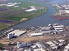
Pittsburg is a city in Contra Costa County, California, United States. It is an industrial suburb located on the southern shore of the Suisun Bay in the East Bay region of the San Francisco Bay Area, and is part of the Sacramento–San Joaquin River Delta area, the Eastern Contra Costa County area, and the San Francisco Bay Area. The population was 76,416 at the 2020 United States Census.

<span class="mw-page-title-main">Charter Oak, California</span> Census designated place in California, United States

Charter Oak is a census-designated place (CDP) in Los Angeles County, California, approximately 26 miles (42 km) east of downtown Los Angeles. The population was 9,310 at the 2010 census, up from 9,027 at the 2000 census.

<span class="mw-page-title-main">West Covina, California</span> City in California, United States

West Covina is a city in Los Angeles County, California, United States. Located 19 miles (31 km) east of downtown Los Angeles in the eastern San Gabriel Valley, it is part of Greater Los Angeles. The population for the city was 109,501 at the 2020 census.

<span class="mw-page-title-main">Fair Oaks, California</span> Census designated place in California, United States

Fair Oaks is a census-designated place (CDP) in Sacramento County, California, United States. It is part of the Sacramento–Arden-Arcade–Roseville Metropolitan Statistical Area. The population was 32,514 at the 2020 census, up from 30,912 at the 2010 census. The Fair Oaks zip code is 95628 and its area codes are 916 and 279. It is bordered to the west by Carmichael, north by the city of Citrus Heights, to the east by Orangevale, and to the south by the American River.

<span class="mw-page-title-main">Woodland, California</span> City in California, United States

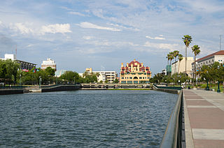
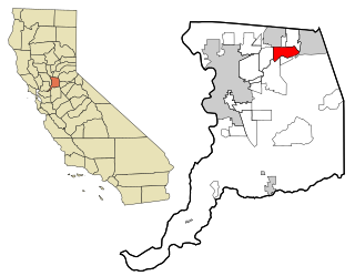
Woodland is a city in, and the county seat of, Yolo County, California, United States, located approximately 15 miles (24 km) northwest of Sacramento, and is a part of the Sacramento metropolitan area. The population was 61,032 at the 2020 census.

<span class="mw-page-title-main">Antelope, California</span> Census-designated place in California, United States

Antelope is a census-designated place in Sacramento County, California, United States located approximately 15 miles (24 km) northeast of downtown Sacramento and 5 miles (8 km) southwest of Roseville. The population was 45,770 at the 2020 census.

<span class="mw-page-title-main">California State Route 275</span> Highway in California

State Route 275 is an unsigned state highway connecting West Sacramento, California and Downtown Sacramento. Since 1996, the highway has been legally defined to be the length of the Tower Bridge crossing the Sacramento River. Prior to that year, SR 275 was also known as the West Sacramento Freeway, and was a short spur connecting Interstate 80 Business / U.S. Route 50 in West Sacramento, and the Tower Bridge. SR 275 also extended east into Sacramento along the Capitol Mall from the bridge to 9th Street, just west of the California State Capitol. West Sacramento completed a project to replace the freeway with a pedestrian-friendly street named Tower Bridge Gateway.

Broderick is a former town in Yolo County, California, United States, now forming part of the City of West Sacramento. It is located just west of the Sacramento River in the eastern portion of the county. Broderick's ZIP Code is 95605 and is in area codes 916 and 279. It lies at an elevation of 23 feet.

Sacramento City Unified School District (SCUSD) is a public school system in Sacramento, California. With 47,900 students in 81 schools, it is the eleventh largest school district in California.

Yolo is an unincorporated community and census-designated place in Yolo County, California. It is located 4.9 miles northwest of the county seat, Woodland and 24 miles northwest of the state capital of Sacramento. Yolo's ZIP Code is 95697 and its area code 530. It lies at an elevation of 82 feet. The population was 421 at the 2020 census.

Bryte is a former town in Yolo County, California, now forming part of West Sacramento. It is located just south of the Sacramento River in the eastern portion of the county. Bryte's ZIP Code is 95605 and is in area codes 916 and 279. It lies at an elevation of 23 feet.

<span class="mw-page-title-main">Knights Landing, California</span> Census-designated place in California, United States

Knights Landing is a census-designated place in Yolo County, California, United States, founded by William Knight. It is located on the Sacramento River around 25 miles northwest of Sacramento in the northeastern portion of the county. Knights Landing's ZIP Code is 95645 and its area code 530. It lies at an elevation of 36 feet. The 2010 census reported that Knights Landing had a population of 995.

<span class="mw-page-title-main">Natomas, Sacramento, California</span> Neighborhood of Sacramento in California, United States

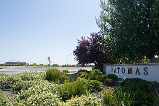
Natomas is a community in the northwestern section of the city of Sacramento, in the U.S. state of California.

References

  1. "California Cities by Incorporation Date". California Association of Local Agency Formation Commissions. Archived from the original (Word) on November 3, 2014. Retrieved August 25, 2014.
  2. "City Council | City of West Sacramento".
  3. "City Manager's Office | City of West Sacramento".
  4. "City Council". City of West Sacramento. Archived from the original on January 13, 2013. Retrieved February 1, 2015.
  5. "California's 6th Congressional District - Representatives & District Map". Civic Impulse, LLC. Retrieved March 8, 2013.
  6. "2019 U.S. Gazetteer Files". United States Census Bureau. Retrieved July 1, 2020.
  7. "West Sacramento". Geographic Names Information System . United States Geological Survey, United States Department of the Interior . Retrieved February 1, 2015.
  8. "West Sacramento (city) QuickFacts". United States Census Bureau. Archived from the original on February 23, 2015. Retrieved February 22, 2015.
  9. "Population and Housing Unit Estimates". United States Census Bureau. May 24, 2020. Retrieved May 27, 2020.
  10. "New Orleans & West Sacramento Named "Most Livable" Cities in America" (PDF) (Press release). Dallas, TX: The United States Conference of Mayors. June 21, 2014.
  11. "Table 1a. Population in Metropolitan and Micropolitan Statistical Areas in Alphabetical Order and Numerical and Percent Change for the United States and Puerto Rico: 1990 and 2000" (PDF), Census 2000, U.S. Census Bureau, December 30, 2003
  12. "Home". West Sacramento Historical Society. Retrieved September 29, 2019.
  13. 1 2 Durham, David L. (1998). California's Geographic Names: A Gazetteer of Historic and Modern Names of the State. Clovis, Calif.: Word Dancer Press. p. 575. ISBN   1-884995-14-4.
  14. "Port of West Sacramento | City of West Sacramento". www.cityofwestsacramento.org. Retrieved September 29, 2019.
  15. U.S. Geological Survey Geographic Names Information System: West Sacramento, California
  16. "West Sacramento, CA". Weatherbase.
  17. "Zipcode 95691". www.plantmaps.com. Retrieved April 12, 2021.
  18. "Sacramento Gold FC". sacramentogoldfc. Retrieved September 29, 2019.
  19. "California Highway Patrol Academy". California Highway Patrol (chp.ca.gov). Retrieved September 17, 2014.
  20. Prero, Mike (September 2004), California Highway Patrol (PDF), Senate Bill 2147 sponsored by State Senator Jack O'Connell gives Commissioner Dwight O. "Spike" Helmick the authorization to plan and construct a California Highway Patrol Museum on the Department's Academy grounds in West Sacramento. The bill requires the construction to be funded entirely with private contributions with the exception of eligible federal funds.
  21. "California Highway Patrol". Arcadia Publishing. 2008. ...and the California Highway Patrol museum located at the CHP Academy in Sacramento...
  22. Shaw, Michael (May 11, 2008). "New CHP HQ takes U-turn". Sacramento Business Journal.
  23. Johnson, Kelly (June 27, 2008). "CHP signs lease for HQ off Richards Boulevard". Sacramento Business Journal.
  24. Bridgeway Island
  25. Elkhorn Elementary School
  26. Riverbank Elementary School
  27. Southport Elementary School
  28. Stonegate Elementary School
  29. Westfield Elementary School
  30. Westmore Oaks Elementary School
  31. Washington Unified School District: River City High School
  32. Washington Unified School District: Independent Study
  33. Washington Unified School District: Preschool Programs
  34. Washington Unified School District: Washington Adult School
  35. Washington Unified School District: Yolo Education Center
  36. Washington Unified School District: Bryte Career and College Training
  37. Sacramento Valley Charter School
  38. Heritage Peak Charter School
  39. Our Lady of Grace, WestSac
  40. Lighthouse Charter School
  41. Sacramento City College, WestSac Center
  42. "West Sacramento Home Run| City of West Sacramento". www.cityofwestsacramento.org. Retrieved September 29, 2019.
  43. "West Sacramento setting the table as a major food industry hub". The Sacramento Bee.
  44. "Census of Population and Housing". Census.gov. Retrieved June 4, 2015.
  45. "2010 Census Interactive Population Search: CA – West Sacramento city". U.S. Census Bureau. Archived from the original on July 15, 2014. Retrieved July 12, 2014.
  46. "U.S. Census website". United States Census Bureau . Retrieved January 31, 2008.
  47. 1 2 "Transit Service | City of West Sacramento". www.cityofwestsacramento.org. Retrieved January 20, 2022.
  48. "On-demand rideshare service launches in West Sac". Daily Democrat. February 5, 2020. Retrieved January 20, 2022.
  49. "West Sacramento's On-Demand Ride-share Service Addresses Transit Needs". Western City Magazine. Retrieved January 20, 2022.