
Cobb is a census designated place (CDP) in Lake County, California, United States. Cobb is located 1 mile (1.6 km) northwest of Whispering Pines, at an elevation of 2,631 feet (802 m). The population was 1,778 at the 2010 census, up from 1,638 at the 2000 census.

Bradley is an unincorporated community and census-designated place (CDP) in Monterey County, California, on the Salinas River 14 miles (23 km) south-southeast of San Ardo and 20 miles (32 km) north of Paso Robles. Bradley sits at an elevation of 548 feet (167 m). The population was 69 at the 2020 census, down from 93 at the 2010 census.

Crestline is a census-designated place in the San Bernardino Mountains of San Bernardino County, California, USA. The population was 10,770 at the 2010 census, up from 10,218 at the 2000 census.
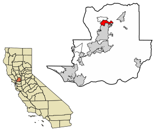
Esparto is a census-designated place (CDP) in Yolo County, California, United States. It is part of the Sacramento–Arden-Arcade–Roseville Metropolitan Statistical Area. The population was 3,108 at the 2010 census.

Dunnigan is a census-designated place in Yolo County, California on Interstate 5. The population was 1,416 at the 2010 census. Dunnigan's ZIP code is 95937 and its area code 530. It lies at an elevation of 69 feet.
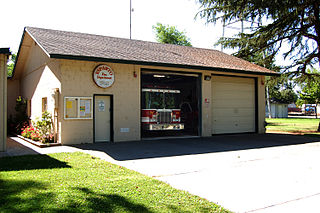
Clarksburg is a census-designated place in Yolo County, California. It is located on the Sacramento River, in the extreme southeastern corner of the county. It lies at an elevation of 10 feet in ZIP code 95612 and area codes 916 and 279.

Calpella is an unincorporated community and census-designated place (CDP) in Mendocino County, California, United States. It is located on the Russian River, 6 miles (10 km) north of Ukiah. It is situated within the Ukiah Valley, at the intersection of U.S. Route 101 and State Route 20. The population was 799 at the 2020 census, up from 679 in 2010. The small town is the site of the Mendocino Redwood Company mill and offices, which controls ten percent of the private land in the county.
Madison is a census-designated place in Yolo County, California. Madison's ZIP Code is 95653 and its area code 530. It is located 10.5 miles (17 km) west of Woodland, at an elevation of 151 feet. The 2020 United States census reported Madison's population was 721.

Knights Landing is a census-designated place in Yolo County, California, United States, founded by William Knight. It is located on the Sacramento River around 25 miles northwest of Sacramento in the northeastern portion of the county. Knights Landing's ZIP Code is 95645 and its area code 530. It lies at an elevation of 36 feet. The 2010 census reported that Knights Landing had a population of 995.
Alta is a small unincorporated community and census-designated place (CDP) in Placer County, California, United States, about 30 miles (48 km) northeast of Auburn. The village is located off Interstate 80 and along the historical First transcontinental railroad. The ZIP code is 95701 and the area code 530. One of the few buildings other than private residences is the Alta-Dutch Flat Grammar School serving kindergarten through eighth grade students. The high school that serves Alta is named Colfax High School. Colfax High School is 11 miles southwest in the incorporated town of Colfax. The population of Alta was 615 at the 2020 census.

Manchester is a census-designated place in Mendocino County, California, United States. It is located 5 miles (8 km) north of Point Arena at an elevation of 85 feet (26 m). The population was 159 at the 2020 census, down from 195 in 2010.
Stevinson is an unincorporated community and census-designated place in Merced County, California. It is located 21 miles (34 km) west of Merced at an elevation of 85 feet (26 m). The population was 275 at the 2020 census, down from 313 at the 2010 census.

Goodyears Bar, known as Slaughter's Bar before 1851, is a census-designated place (CDP) in Sierra County, California, United States. Goodyears Bar is located along the North Yuba River and California State Route 49 3.25 miles (5.23 km) west-southwest of Downieville. Goodyears Bar has a post office with ZIP code 95944. The post office opened in 1851.

Flournoy is a census-designated place (CDP) in Tehama County, California. Flournoy sits at an elevation of 594 feet (181 m). Flournoy is located in the south-western part of the county approximately halfway between the city of Corning and the town of Paskenta, located on Thomes Creek. The zip code is 96029. The 2010 United States census reported Flournoy's population was 101.
Posey is a census-designated place in Tulare County, California, United States. Posey is 21 miles (34 km) east-southeast of Ducor. Posey has a post office with ZIP code 93260, which opened in 1915. The population was 23 at the 2020 United States census, up from 10 at the 2010 census. The elevation of Posey is 3573 feet.
Waukena is a census-designated place in Tulare County, California, United States. Waukena is located on California State Route 137 4 miles (6.4 km) northeast of Corcoran. Waukena has a post office with ZIP code 93282. The population was 108 at the 2010 census. Its name is possible derived from an archaic English interpretation of the Spanish name Joaquina.
Monument Hills is a census-designated place in Yolo County, California. Monument Hills sits at an elevation of 135 feet. The 2010 United States census reported Monument Hills's population was 1,542.
Woodlands is a census-designated place in San Luis Obispo County, California. "The Woodlands" is a 956-acre master planned community with single- and multi-family homes, a resort hotel, retail and office space, located adjacent to Nipomo, California. Woodlands sits at an elevation of 282 feet (86 m). The 2010 United States census reported Woodlands's population was 576.
Hartley is a census-designated place (CDP) in Solano County, California. Hartley sits at an elevation of 131 feet (40 m). The 2010 United States census reported Hartley's population was 2,510.


