
Edensor Park is a suburb of Sydney, New South Wales, Australia. Edensor Park is located 38 kilometres west of the Sydney central business district in the local government area of the City of Fairfield. It is mainly a residential area, Edensor Park is part of the Greater Western Sydney region.

Fairfield is a western suburb of Sydney, in the state of New South Wales, Australia. Being in the centre of the Cumberland Plain, Fairfield is located 30 kilometres (19 mi) west of the Sydney central business district and is the administrative heart of the Fairfield City Council – despite a very small portion of it belonging to the Cumberland Council. Fairfield supports a mixture of commercial and residential developments, mostly characterised by medium-density buildings and some new high-rise apartments.

Abbotsbury is a suburb of Sydney, New South Wales, Australia 39 kilometres west of the Sydney central business district in the local government area of the City of Fairfield. Abbotsbury is part of the Greater Western Sydney region.
Wetherill Park is a suburb in Greater Western Sydney, in the state of New South Wales, Australia. Wetherill Park is located 34 kilometres west of the Sydney central business district, in the local government area of the City of Fairfield.

West Hoxton is a suburb of Sydney, in the state of New South Wales, Australia. West Hoxton is located 40 kilometres west of the Sydney central business district, in the local government area of the City of Liverpool and is part of the Greater Western Sydney region.
St Johns Park is a suburb of Sydney, in the state of New South Wales, Australia 35 kilometres west of the Sydney central business district, in the local government areas of the City of Fairfield. It is part of the Greater Western Sydney region.

Smithfield is a suburb of Sydney, in the state of New South Wales, Australia. Smithfield is located 31 kilometres (19 mi) west of the Sydney central business district, in the local government areas of the City of Fairfield and Cumberland Council. Located in the Greater Western Sydney region, the suburb is one of the largest in Fairfield City by area.

Prairiewood is a suburb of Sydney, in the state of New South Wales, Australia 34 kilometres west of the Sydney central business district, in the local government area of the City of Fairfield. It is part of the Greater Western Sydney region.

Bonnyrigg is a suburb of Sydney, in the state of New South Wales, Australia 36 kilometres west of the Sydney central business district, in the local government area of the City of Fairfield. It is part of the Greater Western Sydney region.
Bonnyrigg Heights is a suburb of Sydney, in New South Wales, Australia. Its name originates from Bonnyrigg, Midlothian, Scotland. Bonnyrigg Heights is located on the traditional indigenous lands of the Dharug Nation.

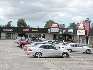
Bossley Park is a suburb of Sydney, in the state of New South Wales, Australia. Bossley Park is located 36 kilometres west of the Sydney central business district in the local government area of the City of Fairfield. Bossley Park is part of the Greater Western Sydney region. The suburb is most well known for being an ethnic enclave of Assyrian and other Iraqi ethnic groups living in Sydney.
Fairfield West is a suburb of Sydney, in the state of New South Wales, Australia. Fairfield West is located 27 kilometres west of the Sydney central business district in the local government area of the City of Fairfield. Fairfield West is part of the Greater Western Sydney region.
Fairfield Heights is a suburb of Sydney, in the state of New South Wales, Australia. Fairfield Heights is located 25 kilometres west of the Sydney central business district in the local government area of the City of Fairfield. Fairfield Heights is part of the Greater Western Sydney region.

Green Valley is a suburb of Sydney, in the state of New South Wales, Australia. Green Valley is located 39 kilometres (24 mi) west of the Sydney central business district, in the local government area of the City of Liverpool and is part of the Greater Western Sydney region.
Greenfield Park is a suburb of Sydney, in the state of New South Wales, Australia. Greenfield Park is located 36 kilometres west of the Sydney central business district in the local government area of the City of Fairfield. The suburb has one of the most highest proportion of Assyrian people in the Sydney area and Australia per se.
Hoxton Park is a suburb of Sydney, in the state of New South Wales, Australia. Hoxton Park is located 38 kilometres west of the Sydney central business district, in the local government area of the City of Liverpool and is part of the Greater Western Sydney region.

Cecil Hills is a suburb of Sydney, in the state of New South Wales, Australia. Cecil Hills is located 38 kilometres west of the Sydney central business district, in the local government area of the City of Liverpool and is part of the Greater Western Sydney region.

Hinchinbrook is a suburb of Sydney, in the state of New South Wales, Australia. Hinchinbrook is located 35 kilometres south-west of the Sydney central business district, in the local government area of the City of Liverpool. It is bordered by Hoxton Park and Green Valley.
Middleton Grange is a suburb of Sydney, in the state of New South Wales, Australia. Middleton Grange is located 40 kilometres west of the Sydney central business district, in the local government area of the City of Liverpool and is part of the Greater Western Sydney region.

The Division of McMahon is an Australian electoral division in the state of New South Wales.
