Esto, Florida

Last updated

Esto, Florida
Town of Esto
Motto: 
"The Home of Two-Toed Tom" [1] [2]
Holmes County Florida Incorporated and Unincorporated areas Esto Highlighted.svg
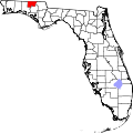
Location in Holmes County and the state of Florida
Usa edcp location map.svg
Red pog.svg
Esto, Florida
Location in the United States
Coordinates: 30°58′52″N85°38′49″W / 30.98111°N 85.64694°W / 30.98111; -85.64694
Country Flag of the United States.svg  United States
State Flag of Florida.svg  Florida
County   Holmes
Incorporated 1963 [3]
Government
  Type President-Council
   Council President [1] Teresa Harrison
   Council Vice President Josh Davenport
   Council Members Greg Wells,
Maxie Yates, and
Garet Skipper
   Town Clerk Ben Tew
   Town Attorney Michelle Blankenship-Jordan
Area
[4]
  Total2.36 sq mi (6.13 km2)
  Land2.18 sq mi (5.64 km2)
  Water0.19 sq mi (0.48 km2)
Elevation
233 ft (71 m)
Population
 (2020)
  Total341
  Density156.49/sq mi (60.41/km2)
Time zone UTC-6 (Central (CST))
  Summer (DST) UTC-5 (CDT)
ZIP code
32425 [5]
Area code 850
FIPS code 12-21250 [6]
GNIS feature ID0282263 [7]
Website estoflorida.com

Esto is a town in Holmes County, Florida, United States. The Town of Esto is located on the Florida Panhandle in North Florida. The population was 341 at the 2020 census.

Contents

Geography

The exact coordinates for the Town of Esto is located in northeastern Holmes County at 30°58′52″N85°38′49″W / 30.98111°N 85.64694°W / 30.98111; -85.64694 (30.981052, –85.646857). [8]

It is bordered to the north by the state of Alabama and to the east by the town of Noma, Florida. Florida State Road 79 is the main road through town, leading south 13 miles (21 km) to Bonifay, the Holmes County seat, and north (as Alabama State Route 167) 9 miles (14 km) to Hartford, Alabama. Florida State Road 2 follows the southern border of Esto, and leads east 8 miles (13 km) to Graceville and west 20 miles (32 km) to State Road 81. Dothan, Alabama, 25 miles (40 km) to the northeast, is the closest city with more than 50,000 people.

According to the United States Census Bureau, the town of Esto has a total area of 2.4 square miles (6.1 km2), of which 2.2 square miles (5.6 km2) are land and 0.2 square miles (0.5 km2), or 7.89%, are water.

Climate

The climate in this area is characterized by hot, humid summers and generally mild winters. According to the Köppen climate classification, the Town of Esto has a humid subtropical climate zone (Cfa).

Demographics

Historical population
CensusPop.Note
1910 340
1920 269−20.9%
1930 190−29.4%
1940 21312.1%
1950 2171.9%
1960 148−31.8%
1970 21041.9%
1980 30444.8%
1990 253−16.8%
2000 35640.7%
2010 3642.2%
2020 341−6.3%
U.S. Decennial Census [9]

2010 and 2020 census

Esto racial composition
(Hispanics excluded from racial categories)
(NH = Non-Hispanic)
RacePop 2010 [10] Pop 2020 [11] % 2010% 2020
White (NH)34229993.96%87.68%
Black or African American (NH)4141.10%4.11%
Native American or Alaska Native (NH)240.55%1.17%
Asian (NH)200.55%0.00%
Pacific Islander or Native Hawaiian (NH)000.00%0.00%
Some other race (NH)030.00%0.88%
Two or more races/Multiracial (NH)461.10%1.76%
Hispanic or Latino (any race)10152.75%4.40%
Total364341

As of the 2020 United States census, there were 341 people, 122 households, and 94 families residing in the town. [12]

As of the 2010 United States census, there were 364 people, 124 households, and 97 families residing in the town. [13]

2000 census

As of the census [6] of 2000, there were 356 people, 144 households, and 95 families residing in the town. The population density was 161.6 inhabitants per square mile (62.4/km2). There were 167 housing units at an average density of 75.8 per square mile (29.3/km2). The racial makeup of the town was 92.13% White, 2.25% African American, 3.93% Native American, 0.56% from other races, and 1.12% from two or more races. Hispanic or Latino of any race were 2.81% of the population.

In 2000, there were 144 households, out of which 30.6% had children under the age of 18 living with them, 50.7% were married couples living together, 9.0% had a female householder with no husband present, and 34.0% were non-families. 31.3% of all households were made up of individuals, and 17.4% had someone living alone who was 65 years of age or older. The average household size was 2.47 and the average family size was 3.09.

In 2000, in the town, the population was spread out, with 28.1% under the age of 18, 7.6% from 18 to 24, 23.3% from 25 to 44, 26.4% from 45 to 64, and 14.6% who were 65 years of age or older. The median age was 37 years. For every 100 females, there were 110.7 males. For every 100 females age 18 and over, there were 100.0 males.

In 2000, the median income for a household in the town was $31,667, and the median income for a family was $36,563. Males had a median income of $30,313 versus $15,625 for females. The per capita income for the town was $12,961. About 15.7% of families and 12.5% of the population were below the poverty line, including 16.8% of those under age 18 and none of those age 65 or over.

Arts and culture

Since 1987, the Two-Toed Tom Festival has been held annually in the town. The theme of the festival is in remembrance of an infamous, 18-foot alligator from the early 1900s that was known to kill farmers' livestock (such as cattle) as well as humans. People would know it was that specific alligator because of his distinctive footprints, being it only had two toes on one of its legs due to a steel animal trap that failed to capture it. This is how he got the name "Two-Toed Tom". Up until the 1970s, people claimed to see Tom or his unique footprints in and around the town and Holmes County. [2]

Related Research Articles

<span class="mw-page-title-main">Macclenny, Florida</span> City in Florida, United States

Macclenny is a city and the county seat of Baker County, Florida. Located just west of Jacksonville, it is a municipalities in the Jacksonville, Florida Metropolitan Statistical Area. The population was 7,304 at the 2020 census, up from 6,374 in 2010.

<span class="mw-page-title-main">Beverly Beach, Florida</span> Town in Florida, United States

Beverly Beach is a town in Flagler County, Florida, United States. The Town of Beverly Beach is part of the Deltona–Daytona Beach–Ormond Beach, FL metropolitan statistical area. The population was 474 at the 2020 census, up from 338 in the 2010 census.

<span class="mw-page-title-main">Havana, Florida</span> Town in the state of Florida, United States

Havana is a town in Gadsden County, Florida, United States, and a suburb of Tallahassee. The population was 1,753 at the 2020 census, almost even from 1,754 at the 2010 census. It is part of the Tallahassee, Florida Metropolitan Statistical Area. The town was named after Havana, Cuba, located about 530 miles (850 km) to the south, due to Cuban cigars made in.

<span class="mw-page-title-main">Fanning Springs, Florida</span> City in Florida, United States

Fanning Springs is a city in Gilchrist and Levy counties in the U.S. state of Florida. It is part of the Gainesville, Florida Metropolitan Statistical Area. The population was 1,182 at the 2020 census, up from 764 at the 2010 census.

<span class="mw-page-title-main">Zolfo Springs, Florida</span> Town in the state of Florida, United States

Zolfo Springs is a town in Hardee County, Florida, United States. It is part of the Florida Heartland region. The population was 1,737 at the 2020 census.

<span class="mw-page-title-main">Bonifay, Florida</span> City in Florida, United States

Bonifay is a city in Holmes County, Florida, United States. As of the 2020 census, the population was 2,759. It is the county seat of Holmes County.

<span class="mw-page-title-main">Noma, Florida</span> Town in the state of Florida, United States

Noma is a town in Holmes County, Florida, United States. The town is part of the Florida Panhandle in North Florida. The population was 208 at the 2020 census.

<span class="mw-page-title-main">Ponce de Leon, Florida</span> Town in the state of Florida, United States

Ponce de Leon is a town in Holmes County, Florida, United States. The Town of Ponce de Leon was named after Spanish explorer, Juan Ponce de León. It is part of the Florida Panhandle in North Florida. The population was 504 at the 2020 census, down from 598 at the 2010 census.

<span class="mw-page-title-main">Westville, Florida</span> Town in the state of Florida, United States

Westville is a town in Holmes County, Florida, United States. Westville is part of the Florida Panhandle in North Florida. As of the 2020 census, the town had a population of 261, down from 289 at the 2010 census. From 2010 to 2020, Westville's population growth percentage was -9.7%.

<span class="mw-page-title-main">Alford, Florida</span> Town in Florida, United States

Alford is a town in Jackson County, Florida, United States. The Town of Alford is located on the Florida Panhandle near Marianna, in North Florida. The population was 484 at the 2020 census.

<span class="mw-page-title-main">Bascom, Florida</span> Town in Florida, United States

Bascom is a town in Jackson County, Florida, United States. The town is located on the Florida Panhandle in North Florida, and is 5 miles (8 km) south of the Alabama border. The population was 121 at the 2020 census.

<span class="mw-page-title-main">Campbellton, Florida</span> Town in Florida, United States

Campbellton is a town in Jackson County, Florida, United States. The town is part of the Florida Panhandle in North Florida, and has a predominately African American majority. The population was 191 at the 2020 census.

<span class="mw-page-title-main">Cottondale, Florida</span> City in Florida, United States

Cottondale is a city in Jackson County, Florida, United States. It is part of the Florida Panhandle and North Florida. The population was 848 at the 2020 census, down from 933 at the 2010 census.

<span class="mw-page-title-main">Malone, Florida</span> Town in the state of Florida, United States

Malone is a town in Jackson County, Florida, United States. The population was 1,959 at the 2020 census.

<span class="mw-page-title-main">Astatula, Florida</span> Town in the state of Florida, United States

Astatula is a town in Lake County, Florida, United States. The population was 1,889 at the 2020 census. It is part of the Orlando–Kissimmee–Sanford Metropolitan Statistical Area.

<span class="mw-page-title-main">Howey-in-the-Hills, Florida</span> Town in the state of Florida, United States

Howey-In-The-Hills is a town in Lake County, Florida, United States. The population was 1,643 at the 2020 census. It is part of the Orlando–Kissimmee–Sanford Metropolitan Statistical Area.

<span class="mw-page-title-main">Umatilla, Florida</span> City in Florida

Umatilla is a city in Lake County, Florida, United States. The population was 3,685 at the 2020 census. Umatilla is known as the Gateway to the Ocala National Forest, located in northern Lake County.

<span class="mw-page-title-main">Inglis, Florida</span> Town in Florida, United States

Inglis is a town in Levy County, Florida, United States. It is on U.S. Highway 19 near the Cross Florida Greenway. As of the 2020 census, the town had a population of 1,476, up from 1,325 at the 2010 census. It is part of the Gainesville, Florida Metropolitan Statistical Area.

<span class="mw-page-title-main">Pomona Park, Florida</span> Town in the state of Florida, United States

Pomona Park is a town in Putnam County, Florida, United States. The Town of Pomona Park is part of the Palatka, Florida Micropolitan Statistical Area. The population was 784 at the 2020 census, down from 912 at the 2010 census.

<span class="mw-page-title-main">Paxton, Florida</span> Town in the state of Florida, United States

Paxton is a town in Walton County, Florida, United States. Located near Britton Hill on the Alabama–Florida state line, it has the highest elevation of any in Florida. The Town of Paxton is located on the Florida Panhandle, and is part of the Crestview–Fort Walton Beach–Destin, Florida Metropolitan Statistical Area. The population was 556 as of the 2020 census, down from 644 at the 2010 census.

References

  1. 1 2 "Contact: Esto, Florida". estoflorida.com.
  2. 1 2 "THE LEGEND OF TWO-TOED TOM". www.twotoedtomfest.com.
  3. "FLORIDA CITIES BY INCORPORATION YEAR WITH INCORPORATION & DISSOLUTION INFO" (PDF). www.flcities.com.
  4. "2020 U.S. Gazetteer Files". United States Census Bureau. Retrieved October 31, 2021.
  5. "Esto FL ZIP Code". zipdatamaps.com. 2023. Retrieved February 17, 2023.
  6. 1 2 "U.S. Census website". United States Census Bureau . Retrieved January 31, 2008.
  7. "US Board on Geographic Names". United States Geological Survey. October 25, 2007. Retrieved January 31, 2008.
  8. "US Gazetteer files: 2010, 2000, and 1990". United States Census Bureau. February 12, 2011. Retrieved April 23, 2011.
  9. "Census of Population and Housing". Census.gov. Retrieved June 4, 2015.
  10. "P2 HISPANIC OR LATINO, AND NOT HISPANIC OR LATINO BY RACE - 2010: DEC Redistricting Data (PL 94-171) - Esto town, Florida". United States Census Bureau .
  11. "P2 HISPANIC OR LATINO, AND NOT HISPANIC OR LATINO BY RACE - 2020: DEC Redistricting Data (PL 94-171) - Esto town, Florida". United States Census Bureau .
  12. "S1101 HOUSEHOLDS AND FAMILIES - 2020: Esto town, Florida". United States Census Bureau .
  13. "S1101 HOUSEHOLDS AND FAMILIES - 2010: Esto town, Florida". United States Census Bureau .