Related Research Articles

Mollisols are a soil order in USDA soil taxonomy. Mollisols form in semi-arid to semi-humid areas, typically under a grassland cover. They are most commonly found in the mid-latitudes, namely in North America, mostly east of the Rocky Mountains, in South America in Argentina (Pampas) and Brazil, and in Asia in Mongolia and the Russian Steppes. Their parent material is typically base-rich and calcareous and include limestone, loess, or wind-blown sand. The main processes that lead to the formation of grassland Mollisols are melanisation, decomposition, humification and pedoturbation.
The World Reference Base for Soil Resources (WRB) is an international soil classification system for naming soils and creating legends for soil maps. The currently valid version is the Update 2015 of the third edition 2014. It is edited by a working group of the International Union of Soil Sciences (IUSS).
Solonetz is a Reference Soil Group of the World Reference Base for Soil Resources (WRB). They have, within the upper 100 cm of the soil profile, a so-called "natric horizon". There is a subsurface horizon (subsoil), higher in clay content than the upper horizon, that has more than 15% exchangeable sodium. The name is based on the Russian соль. Ukrainian folk word "solontsi" means salty soil. In Ukraine there are many villages that are called Solontsі.
The Canadian System of Soil Classification is more closely related to the American system than any other, but they differ in several ways. The Canadian system is designed to cover only Canadian soils. The Canadian system dispenses with the sub-order hierarchical level. Solonetzic and Gleysolic soils are differentiated at the order level.
A Stagnosol in the World Reference Base for Soil Resources (WRB) is soil with strong mottling of the soil profile due to redox processes caused by stagnating surface water.

Agula is a town located in northern Ethiopia. Located in the Debubawi (Southern) Zone of the Tigray Region, it lies about 32 km northeast of Mek'ele, just east of the Mek'ele - Addis Ababa highway, and 25 km north of Qwiha. It has a latitude and longitude of 13°41′30″N39°35′30″E with an elevation of 1930 metres above sea level. Nearby is a stream and a pass which share the same name.

Freweyni is a town in northern Ethiopia. Located 80 kilometers north of Mekele in the Misraqawi Zone of the Tigray Region of Ethiopia, this town has a latitude and longitude of 14°3′N39°34′E with an elevation of 2480 meters above sea level and is located along Ethiopian Highway 2.

Maimekden is a village in Tigray Region, located 27 kilometers south of Wukro. It is located on the crossing of Ethiopian Highway 2 and the Mai Mekden river, flowing west to the Geba River.
The Polish Soil Classification is a soil classification system used to describe, classify and organize the knowledge about soils in Poland.
A Retisol is a Reference Soil Group of the World Reference Base for Soil Resources (WRB). Retisols are characterized by clay migration and an additional specific feature: The clay-poorer and lighter coloured eluvial horizon intercalates netlike into the clay-richer more intensely coloured illuvial horizon. The illuvial horizon is the diagnostic argic horizon, and the intercalation is called retic properties.

Mika’el Abiy is a tabia or municipality in the Dogu’a Tembien district of the Tigray Region of Ethiopia. The tabia centre is in Megesta village, located approx. 7 km to the southeast of the woreda town Hagere Selam.

Menachek is a tabia or municipality in the Dogu'a Tembien district of the Tigray Region of Ethiopia. The tabia centre is in Addi Bayro village, located approximately 12 km to the southwest of the woreda town Hagere Selam.
Ayninbirkekin is a tabia or municipality in the Dogu'a Tembien district of the Tigray Region of Ethiopia. The tabia centre is in Halah village, located approximately 8 km to the east of the woreda town Hagere Selam.

The soils of the Kilte Awula’ilo woreda (district) in Tigray reflect its longstanding agricultural history, highly seasonal rainfall regime, relatively low temperatures, the presence of a wide depression at the foot of the Atsbi horst and steep slopes. Outstanding features in the soilscape are the wide ancient fluvial deposits, the soils of the granite batholith, cuestas and fertile lands behind tufa dams.
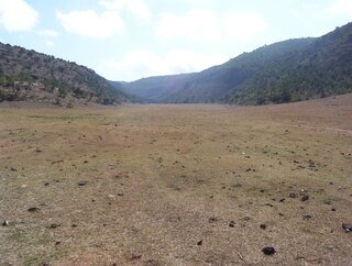
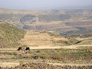
The soils of the Atsbi Wenberta woreda (district) in Tigray (Ethiopia) reflect its longstanding agricultural history, highly seasonal rainfall regime and relatively low temperatures. The northern part of the district is on the high uplifted Atsbi Horst, whereas the southern part is dominated by the Des’a forest on Antalo Limestone. In between there is the fluvial landscape of Hayqi Meshal. Particularities in the southern part of the district are soil catenas on intervening plains behind tufa dams and in a polje.

The soils of the Sa'isi Tsa'ida Imba woreda (district) in Tigray (Ethiopia) reflect its longstanding agricultural history, highly seasonal rainfall regime, relatively low temperatures, overall dominance of metamorphic and sandstone lithology and steep slopes.
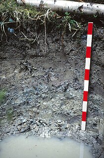
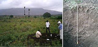
The soils of the Inderta woreda (district) in Tigray (Ethiopia) reflect its longstanding agricultural history, highly seasonal rainfall regime, relatively low temperatures, overall dominance of limestone and dolerite lithologies and steep slopes. Outstanding features in the soilscape are wide plains with Vertisols.
The soils of the Tanqwa Abergele woreda (district) in Tigray (Ethiopia) reflect its longstanding agricultural history, highly seasonal rainfall regime, relatively high temperatures, overall dominance of Precambrian metamorphic rocks and steep slopes.

The soils of the Kola Tembien woreda (district) in Tigray (Ethiopia) reflect its longstanding agricultural history, highly seasonal rainfall regime, relatively high temperatures, overall dominance of sandstone and metamorphic lithology and steep slopes.

The soils of the Dogu’a Tembien woreda (district) in Tigray (Ethiopia) reflect its longstanding agricultural history, highly seasonal rainfall regime, relatively low temperatures, an extremely great variety in lithology and steep slopes. Outstanding features in the soilscape are the fertile highland Vertisols and Phaeozems in forests.