
Gelisols are an order in USDA soil taxonomy. They are soils of very cold climates which are defined as containing permafrost within two meters of the soil surface. The word "Gelisol" comes from the Latin gelare meaning "to freeze", a reference to the process of cryoturbation that occurs from the alternating thawing and freezing characteristic of Gelisols.

A vertisol, or vertosol, is a soil type in which there is a high content of expansive clay minerals, many of them known as montmorillonite, that form deep cracks in drier seasons or years. In a phenomenon known as argillipedoturbation, alternate shrinking and swelling causes self-ploughing, where the soil material consistently mixes itself, causing some vertisols to have an extremely deep A horizon and no B horizon.. This heaving of the underlying material to the surface often creates a microrelief known as gilgai.

In USDA soil taxonomy, Entisols are defined as soils that do not show any profile development other than an A horizon. An entisol has no diagnostic horizons, and most are basically unaltered from their parent material, which can be unconsolidated sediment or rock. Entisols are the most abundant soil order, occupying about 16% of the global ice-free land area.
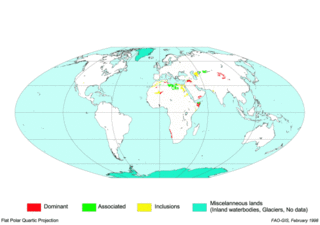
The World Reference Base for Soil Resources (WRB) is an international soil classification system for naming soils and creating legends for soil maps. The currently valid version is the fourth edition 2022. It is edited by a working group of the International Union of Soil Sciences (IUSS).

In soil classification, an Umbrisol is a soil with a dark topsoil and in which organic matter has accumulated within the mineral surface soil—in most cases with low base saturation—to the extent that it significantly affects the behaviour and utilization of the soil. Umbrisols are the counterpart of comparable soils with a high base saturation.
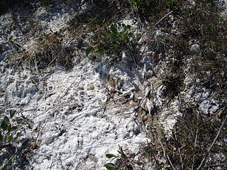
Gypsisols in the World Reference Base for Soil Resources (WRB) are soils with substantial secondary accumulation of gypsum (CaSO4.2H2O). They are found in the driest parts of the arid climate zone. In the USDA soil taxonomy they are classified as Gypsids (USDA Soil Taxonomy), in the Russian soil classification they are called Desert soils (USSR).
Solonchak is a Reference Soil Group of the World Reference Base for Soil Resources (WRB). It is a pale or grey soil type found in arid to subhumid, poorly drained conditions. The word is Russian for "salt marsh" in turn from Russian sol (соль), "salt". Ukrainian folk word "солончак" in turn from Ukrainian "salty" (солоний) + "чак"—suffix; designation of an object that has the property. In Ukraine there is a village Solonchaky.

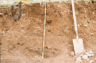
A Calcisol in the World Reference Base for Soil Resources (WRB) is a soil with a substantial secondary accumulation of lime. Calcisols are common in calcareous parent materials and widespread in arid and semi-arid environments. Formerly Calcisols were internationally known as Desert soils and Takyrs.

A Cambisol in the World Reference Base for Soil Resources (WRB) is a soil in the beginning of soil formation. The horizon differentiation is weak. This is evident from weak, mostly brownish discolouration and/or structure formation in the soil profile.

In the World Reference Base for Soil Resources (WRB), a Durisol is a soil of arid and semi-arid environments that contains cemented secondary silica (SiO2) in the upper metre of soil, either as concretions (durinodes – duric horizon) or als continuously cemented layer (duripan – hardpan (Australia) – dorbank (South Africa) – petroduric horizon). In the FAO/Unesco Soil Map of the World, the Durisols with petroduric horizon were indicated as duripan phase of other soils, e.g. of Xerosols and Yermosols.
A Regosol in the World Reference Base for Soil Resources (WRB) is very weakly developed mineral soil in unconsolidated materials. Regosols are extensive in eroding lands, in particular in arid and semi-arid areas and in mountain regions. Internationally, Regosols correlate with soil taxa that are marked by incipient soil formation such as Entisols in the USDA soil taxonomy or Rudosols and possibly some Tenosols in the Australian Soil Classification.

A Planosol in the World Reference Base for Soil Resources is a soil with a light-coloured, coarse-textured, surface horizon that shows signs of periodic water stagnation and abruptly overlies a dense, slowly permeable subsoil with significantly more clay than the surface horizon. In the US Soil Classification of 1938 used the name Planosols, whereas its successor, the USDA soil taxonomy, includes most Planosols in the Great Groups Albaqualfs, Albaquults and Argialbolls.
A Technosol in the World Reference Base for Soil Resources is a Reference Soil Group that combines soils whose properties and pedogenesis are dominated by their technical origin. They contain either a significant amount of artefacts, some sort of geotechnical liner, or are sealed by technic hard rock. They include soils from wastes, pavements with their underlying unconsolidated materials, soils with geomembranes and constructed soils in human-made materials. However, Technosols can also refer to a situation in which normal soil, such as a Chernozem, has been moved to a new location to act as a fill. If this fill is less than 50 cm, then the soil is called a Technosol. If fill material is greater than 50 cm deep, then the fill is designated by the original soil used to create the fill, in our example, a Chernozem. Technosols are often referred to as urban or mine soils. They are recognized in the new Russian soil classification system as Technogenic Superficial Formations.
An Alisol is a Reference Soil Group of the World Reference Base for Soil Resources (WRB).
An anthrosol in the World Reference Base for Soil Resources (WRB) is a type of soil that has been formed or heavily modified due to long-term human activity, such as from irrigation, addition of organic waste or wet-field cultivation used to create paddy fields.
Kastanozem is one of the 32 Reference Soil Groups of the World Reference Base for Soil Resources (WRB). These soils are brighter than Chernozems, and are related to the Mollisols in the USDA soil taxonomy. They are rich in humus, and originally covered with early maturing native grasslands vegetation, which produces a characteristic brown surface layer in the first meter in depth. They have a relative high level of available calcium ions bound to soil particles and can have a petrocalcic horizon between 25 and 100 cm thick.
Luvisols are a group of soils, comprising one of the 32 Reference Soil Groups in the international system of soil classification, the World Reference Base for Soil Resources (WRB). They are widespread, especially in temperate climates, and are generally fertile. Luvisols are widely used for agriculture.
Plinthosols are iron-rich soils characterized by the presence of plinthite, petroplinthite or pisoliths.

A nitisol in the World Reference Base for Soil Resources (WRB) is a deep, red, well-drained soil with a clay content of more than 30% and a blocky structure. Nitisols correlate with the kandic alfisols, ultisols and inceptisols of the USDA soil taxonomy.

A Phaeozem in the World Reference Base for Soil Resources (WRB) is a dark soil with a high base status, but without a secondary carbonates within one metre of the soil surface. Phaeozems correlate with the Udolls and Aquolls (Mollisols) of the USDA soil taxonomy.

