Faisalabad Division

Last updated

Faisalabad Division
فیصل آباد ڈویژن
Pakistan - Punjab - Faisalabad (division).svg
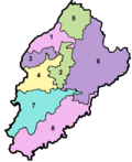
Map of Faisalabad Division
Country Flag of Pakistan.svg  Pakistan
Province Flag of Punjab.svg Punjab
Capital Faisalabad
Government
  TypeDivisional Administration
  CommissionerN/A
  Regional Police OfficerN/A
Area
  Total17,917 km2 (6,918 sq mi)
Population
 (2017) [1]
  Total14,177,081
  Density790/km2 (2,000/sq mi)
Website faisalabaddivision.punjab.gov.pk

Faisalabad Division is an administrative division of Punjab, Pakistan. The reforms of 2000 abolished the third tier of government but was restored again in 2008. [2] [3]

Contents

Districts

It consists of the following districts: [4]

DistrictArea (km²)Population (2017) [1]
Faisalabad 5,8567,873,910
Jhang 6,1662,743,416
Toba Tek Singh 4,3642,190,015
Chiniot
2,6431,369,740
Total17,91714,177,081

Demographics

According to 2017 census, Faisalabad division had a population of 14,177,081, which includes 7,233,831 males and 6,949,921 females. Faisalabad division constitutes 13,769,252 Muslims, 338,590 Christians, 74,749 Ahmadi followed by 597 scheduled castes, 381 Hindus and 1,662 others.

Religions in Faisalabad Division (2017)

   Islam (97.12%)
   Christianity (2.38%)
   Ahmadi (0.5%)
  Other (0.012%)

See also

Related Research Articles

<span class="mw-page-title-main">Faisalabad</span> City in Punjab, Pakistan (formerly Lyallpur)

Faisalabad, formerly known as Lyallpur, is the second largest city and industrial centre of the Pakistani province of Punjab. It is the third largest city in Pakistan, with a population of over 3.7 million. It is situated in the north-east of the country, lying between the plains of the Ravi and Chenab River. Faisalabad is one of Pakistan's wealthiest and most industrialized cities, the largest industrial hub and second largest city of the wider Punjab region.

<span class="mw-page-title-main">Administrative units of Pakistan</span> Provinces and territories under the administrative authority of Pakistan

The administrative units of Pakistan comprise four provinces, one federal territory, and two disputed territories: the provinces of Punjab, Sindh, Khyber Pakhtunkhwa, and Balochistan; the Islamabad Capital Territory; and the administrative territories of Azad Jammu and Kashmir and Gilgit–Baltistan. As part of the Kashmir conflict with neighbouring India, Pakistan has also claimed sovereignty over the Indian-controlled territories of Jammu and Kashmir and Ladakh since the First Kashmir War of 1947–1948, but has never exercised administrative authority over either region. All of Pakistan's provinces and territories are subdivided into divisions, which are further subdivided into districts, and then tehsils, which are again further subdivided into union councils.

<span class="mw-page-title-main">Districts of Pakistan</span> Third-level administrative divisions of Pakistan

The Districts of Pakistan are the third-order administrative divisions of Pakistan, below provinces and divisions, but forming the first-tier of local government. In total, there are 170 districts in Pakistan including the Capital Territory and the districts of Azad Kashmir and Gilgit Baltistan. These districts are further divided into Tehsils, Union Councils.

<span class="mw-page-title-main">Toba Tek Singh District</span> District in Punjab, Pakistan

Toba Tek Singh District is a district of Faisalabad Division in the Punjab province of Pakistan. It is located between 30°33' to 31°2' Degree north latitudes and 72°08' to 72°48' Degree longitudes. It became a separate district in 1982.

<span class="mw-page-title-main">Hazara Division</span> Administrative division of Khyber Pakhtunkhwa, Pakistan

Hazara Division is an administrative division of the Khyber Pakhtunkhwa province of Pakistan. It is located along the Indus River and comprises eight districts: Abbottabad, Mansehra, Haripur, Battagram, Upper Kohistan, Kolai-Palas, Lower Kohistan, Torghar and most recently created Allai District

<span class="mw-page-title-main">Rawalpindi Division</span> Division in Punjab, Pakistan

Rawalpindi Division, also known as Pothohar/Pothwar/Panjistan or North Panjab Region locally, is an administrative division of Punjab Province, Pakistan. Rawalpindi city is the capital of the division. According to the 2017 Census of Pakistan, the total population of division was 10 million. Divisions are the third tier of government below the federal and provincial levels.

<span class="mw-page-title-main">Attock District</span> District of Punjab in Pakistan

Attock District is a district in Pothohar Plateau of the Punjab Province of Pakistan. Its capital is Attock city.

<span class="mw-page-title-main">Sargodha District</span> District in Punjab, Pakistan

Sargodha District, is a district of Punjab, Pakistan. The capital of the district is Sargodha. It is an agricultural district, wheat, rice, and sugarcane along with Kinno being its main crops. The Sargodha district and region is also famous for citrus fruit including Kinnow, orange and lemon. The district has an area of 5,864 km2.

Lalian is a town in Lalian Tehsil and in the Chiniot District of Punjab province, in Pakistan. It is located at 31°49'21N 72°47'50E with an altitude of 171 metres (564 feet) and is situated on the Faisalabad-to-Sargodha road.

<span class="mw-page-title-main">Divisions of Pakistan</span> Second-level administrative divisions of Pakistan

The four provinces, capital territory and two autonomous territories of Pakistan are subdivided into 39 administrative "divisions", which are further subdivided into districts, tehsils and finally union councils. These divisions were abolished in 2000, but restored in 2008.

<span class="mw-page-title-main">Faisalabad District</span> District in Punjab, Pakistan

Faisalabad District is one of the districts of Punjab province, Pakistan. According to the 1998 census of Pakistan it had a population of 3,029,547 of which almost 42% were in Faisalabad City. It is the third largest city of Pakistan after Karachi and Lahore.

<span class="mw-page-title-main">Bahawalpur Division</span> Division in Punjab, Pakistan

Bahawalpur Division is an administrative division of the Punjab Province, Pakistan. The reforms of 2000 abolished the third tier of government but division system was restored again in 2008.

<span class="mw-page-title-main">Lahore Division</span> Division in Punjab, Pakistan

Lahore Division is an administrative division of Punjab Province, Pakistan. It comprises four Districts - Kasur, Lahore, Nankana Sahib and Sheikhupura. The Lahore Division is commanded by a Commissioner to manage the division. Under the Commissioner there are four Additional Commissioners. For each district there is a Deputy Commissioner. Under the reforms of 2000, this tier of government was abolished, but in 2008 divisions were restored.

<span class="mw-page-title-main">Multan Division</span> Division in Pakistan

Multan Division is an administrative division of Punjab Province, Pakistan. The reforms of 2000 abolished the third tier of government but the division system was restored again in 2008.

<span class="mw-page-title-main">Sargodha Division</span> Division in Punjab, Pakistan

Sargodha Division is an administrative division of Punjab province, Pakistan. Sargodha city is the capital of the division. According to the 2017 Census of Pakistan, the total population of the division was 8.18 million. Divisions are the third tier of government below the federal and provincial levels.

Faisalabad Medical University Urdu: فیصل آباد جامعه طب; abbr.FMU), is a public university located in Faisalabad, Punjab, Pakistan, on a 158-acre (0.64 km2) campus on Sargodha Road. It was established in 1973. Teaching hospitals affiliated with the university are Allied Hospital, District Headquarters Hospital and Government General Hospital, Ghulam Muhammad Abad, Faisalabad. The chief executive is Dr. Zafar Chaudhry, a laparoscopic surgeon. The first group of graduates with M.B.B.S degrees graduated in 1978.

<span class="mw-page-title-main">Dera Ghazi Khan Division</span> Division in Punjab, Pakistan

Dera Ghazi Khan Division is an administrative division of the Punjab Province, Pakistan. The reforms of 2000 abolished the third tier of government but division system was restored again in 2008. Hindko and Pashto are the two dominant languages of this division

<span class="mw-page-title-main">Karachi East District</span> District of Sindh in Pakistan

Karachi East District is an administrative district of Karachi Division in Sindh, Pakistan.

<span class="mw-page-title-main">Rana Muhammad Afzal Khan</span> Pakistani politician (1949–2019)

Rana Muhammad Afzal Khan was a Pakistani politician, businessman and Army officer who served as leader of PML-N, and Minister of State for Finance and Economic Affairs in the Abbasi cabinet from December 2017 to May 2018. He was a member of the National Assembly of Pakistan, from June 2013 to May 2018, where he was the Parliamentary Secretary for Finance, Revenue and Privatisation. Previously, he was a Member of the Provincial Assembly of Punjab from 1997 to 1999 and again from 2008 to 2013.

References

  1. 1 2 "DISTRICT WISE CENSUS RESULTS CENSUS 2017 (page 6 0f 13)" (PDF). Pakistan Bureau of Statistics, Government of Pakistan website. Archived from the original (PDF) on 29 August 2017. Retrieved 25 January 2023.
  2. "Number of Teaching Hospitals, DHQ Hospitals, THQ Hospitals, Rural Health Centers and Basic Health Units in Punjab Province" (PDF). Health Department, Government of the Punjab website. Archived from the original (PDF) on 16 April 2015. Retrieved 25 January 2023.
  3. "Punjab Government Plans to Carve a New District from Lahore". 6 January 2009. Archived from the original on 3 June 2010.
  4. "Divisions/Districts of Pakistan (for administrative purposes)". Election Commission of Pakistan website. Archived from the original on 30 September 2006. Retrieved 25 January 2023.
    Note: Although divisions as an administrative structure were abolished in 2000, but were restored again in 2008. The Election Commission of Pakistan still groups districts under the division names.

31°15′N72°48′E / 31.250°N 72.800°E / 31.250; 72.800