Fallowfield Loop

Last updated

Cyclists on the Fallowfield Loop in September 2013 Fallowfield Loop (9884203675).jpg
Cyclists on the Fallowfield Loop in September 2013

The Fallowfield Loop is an off-road cycle path, pedestrian and horse riding route in the south of Manchester, England, which is one of the National Cycle Network routes and paths; it was developed and built by Sustrans, forming part of routes 6 and 60. [1]

Contents

The Loop follows the route of the former Fallowfield Loop railway line, which closed in 1988. It is 8 miles (13 km) long and connects Chorlton-cum-Hardy in the west with Fairfield in the east, passing through Whalley Range, Fallowfield, Levenshulme and Gorton. [2]

History

The historical route of the Fallowfield Loop railway line (1892-1969, freight only until 1988), with the modern Metrolink route. Fallowfield loop line map.png
The historical route of the Fallowfield Loop railway line (1892–1969, freight only until 1988), with the modern Metrolink route.

The Fallowfield Loop railway line was a local railway route in Greater Manchester. Trains on the Manchester, Sheffield and Lincolnshire Railway line (later, the Great Central Railway line) from Sheffield Victoria and Guide Bridge used the "Loop" to access Manchester Central railway station. [3] At Chorlton-cum-Hardy the line joined with the Manchester South District Line on the route into Manchester Central. [4]

The Fallowfield Loop Line was fully opened to passengers in 1892. On 7 July 1958, the stations at Hyde Road, Levenshulme South, Fallowfield and Wilbraham Road were closed, although the line itself remained open to through passenger services until 5 May 1969, after which it was operated as a freight-only route. The loop line also provided access to Reddish Electric Depot, which was built adjacent to the line in 1954 to maintain the new fleet of electric trains for the Woodhead Line; the depot closed in 1983. [3] In March 1987, a short section of track at the former site of Hyde Road station was briefly used to give a public demonstration of the proposed Manchester Metrolink tram system, with a temporary station named Debdale Park constructed beside the line. Soon after this, the line was finally closed and the railway tracks were lifted in October 1988. [3]

Conversion to a shared-use path

The Fallowfield Loop path near Nelstrop Road, Reddish. The Thirlmere Aqueduct passing over the Fallowfield Loop (8514240210).jpg
The Fallowfield Loop path near Nelstrop Road, Reddish.

The old railway route had lain derelict for many years until the late 1990s, when a group of cyclists started campaigning for its conversion to a traffic-free greenway across south Manchester. That group, together with supporters from local civic societies and other community groups, formally became the Friends of the Fallowfield Loop in June 2001. The route is now owned mostly by Sustrans, a charity which specialises in building and maintaining off-road shared-use paths. [5]

There are many access points onto the Loop along its length from Wilbraham Road in Chorlton-cum-Hardy, at its western end, to Fairfield station in the east. There are also several metal barriers along the route which, until late 2016, would disrupt the ride for cyclists on normal-size bikes; larger cycles, like tandems and trikes, had to be lifted over them. However, after a successful trial period in 2016, the barriers along the route itself are now open permanently. The barriers at the different entrance points to the Loop are a variety of designs; some of these are still very difficult to access using a normal bicycle, whilst others have been modified to be fully accessible even for tandems.[ citation needed ]

Along the route

Remnants of the former railway are still in evidence along the route, such as the former Fallowfield railway station buildings next to the cycle path at the Wilmslow Road access point. Fallowfield Railway Station 01.jpg
Remnants of the former railway are still in evidence along the route, such as the former Fallowfield railway station buildings next to the cycle path at the Wilmslow Road access point.

The Fallowfield Loop forms a green structure in an arc around Manchester city centre, linking parks and open spaces. Near its western end, the Loop crosses the South Manchester Line of Greater Manchester's light-rail Metrolink system at St Werburgh's Road Metrolink station. There is a National Cycle Network fossil tree milepost, designed by John Mills, in the section of the Loop between Broom Lane and Stockport Road; there are Sustrans murals underneath the former railway bridges at Stockport Road and Wellington Road. Towards the east of the route, the Loop passes Highfield Country Park, Debdale Park and Gorton Reservoirs, and intersects Gorton Heritage Trail. Travelling up Route 60 from the Debdale Park access point leads to Ashton Canal, the Manchester Velodrome and the City of Manchester Stadium. The Thirlmere Aqueduct passes over the Loop near the Nelstrop Road access point and the Elisabeth Svendsen Trust Donkey Sanctuary is also located along the route, at Abbey Hey. The Friends of the Fallowfield Loop have produced a map showing points of interest on the Loop.

There are some stone sculptures on the Loop in Whalley Range and Levenshulme, with three wooden sculptures called Man, Woman and Child by local artist Rachel Ramchurn, near Highfield Country Park. [6]

In 2019, Manchester City Council announced plans to widen Hyde Road, the A57, by removing the former railway bridge by which the path crosses it and replacing it with a new bridge. This was planned to take about a year, during which the cycle path could be disrupted. It proposed to include a new connection to the path using a stairway. [7] [8] The new bridge was opened in July 2020, but no stairway was built. The council then announced plans to spend £4.9 million on improvements to the path, including improved entry and exit points, transformed open spaces, children's play areas and seating. [9]

The former Levenshulme South railway station was transformed in 2022 into a cycle café, bar, urban garden, restaurant and bike workshop as a social enterprise called Station South. [10]

Crime and antisocial behaviour on the Loop

Despite an announcement by the Mayor of Greater Manchester Andy Burnham of plans to invest £160 million on the 'Bee Safe Network' of cycleways and walking routes, fears that antisocial behaviour and crime along the route that had already existed including 21 cyclists attacked in autumn 2018, increased.[ citation needed ] In light of this, there were calls for Greater Manchester Police to take cycle crime in Manchester more seriously - as the incidents put people off using the Loop as a commuter and leisure route. [11] The route should benefit from a share of the Greater Manchester 'Safer Streets Fund'. [12]

See also

Related Research Articles

<span class="mw-page-title-main">Fallowfield</span> Suburb of Manchester

Fallowfield is a suburb of Manchester, England, with a population at the 2011 census of 15,211. Historically in Lancashire, it lies 3 miles (5 km) south of Manchester city centre and is bisected east–west by Wilbraham Road and north–south by Wilmslow Road. The former Fallowfield Loop railway line, now a shared use path, follows a route nearly parallel with the east–west main road.
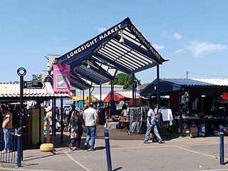
<span class="mw-page-title-main">Gorton</span> Area of Manchester, England

Gorton is an area of Manchester in Greater Manchester, North West England. It is to the southeast of Manchester city centre. The population at the 2011 census was 36,055. Neighbouring areas include Levenshulme and Openshaw.

<span class="mw-page-title-main">Levenshulme</span> Suburb of Manchester, England

Levenshulme is an area of Manchester, England, bordering Fallowfield, Longsight, Gorton, Burnage, Heaton Chapel and Reddish, halfway between Stockport and Manchester city centre on the A6. Levenshulme is predominantly residential with numerous fast food shops, public houses and antique stores. It has a multi-cultural and multi-ethnic population of 15,430 at the 2011 Census. The Manchester to London railway line passes through Levenshulme railway station.

<span class="mw-page-title-main">Fairfield railway station (England)</span> Railway station in Greater Manchester, England

Fairfield railway station serves the Fairfield area of Droylsden, Tameside, Greater Manchester and is located 3.1 miles (5 km) east of Manchester Piccadilly station. It was opened by the Manchester, Sheffield & Lincolnshire Railway in 1892, when the Fallowfield Loop to Manchester Central opened; it replaced an earlier station that had opened on the line in 1841, west of the present site. For a suburban station, Fairfield has very low passenger usage.

<span class="mw-page-title-main">Chorlton tram stop</span> Manchester Metrolink tram stop

Chorlton is a stop on the South Manchester Line (SML) and Airport Line of the Metrolink light-rail system in Chorlton-cum-Hardy, Manchester, England. It was built as part of Phase 3a of the network's expansion, and opened on 7 July 2011 on a section of the former Cheshire Lines Committee railway.

<span class="mw-page-title-main">Fallowfield railway station</span> Disused railway station in Manchester, England

Fallowfield railway station is a disused station that is located on Wilmslow Road in Fallowfield, a southern suburb of Manchester, England. It was on the Fallowfield Loop railway line, a suburban railway which looped around the south of the city and terminated at the former Manchester Central railway station. The station closed to passengers in 1958, but its building still stands on the corner of Wilmslow Road and Ladybarn Road.

<span class="mw-page-title-main">Hyde Road railway station</span> Former railway station in east Manchester, England

Hyde Road was a railway station in Gorton, Manchester, England, on the Fallowfield Loop Line. It opened in 1892 and closed in 1958, when local passenger services on the line were withdrawn. The station was sometimes advertised as Hyde Road for Belle Vue, given its close proximity to Belle Vue Zoo which was about one mile away. The line was closed completely in 1988 and the track was taken up. The station has long since been demolished and the site was partly redeveloped. The former trackbed is now a popular shared use path called the Fallowfield Loop.

<span class="mw-page-title-main">Fallowfield Loop railway line</span> Disused railway line in south Manchester, England

The Fallowfield Loop railway line was a local railway route in south Manchester, England. Trains on the Manchester, Sheffield and Lincolnshire Railway (MS&LR) line from Sheffield Victoria and Guide Bridge used the Loop to access Manchester Central. Some express trains, including the Harwich-Liverpool boat train, used the line.

National Cycle Route 6 is a route of the National Cycle Network, running from London to the Lake District.

<span class="mw-page-title-main">Levenshulme South railway station</span> Former railway station in England

Levenshulme South was a railway station in Levenshulme, Manchester, England; it was sited on the Fallowfield Loop railway line, which has since closed and is now a shared-use path.

<span class="mw-page-title-main">Wilbraham Road railway station</span> Former railway station in south Manchester, England

Wilbraham Road railway station was in Whalley Range, Manchester, England, on the Fallowfield Loop line between Manchester Central and Fairfield, via Chorlton. Opened as Alexandra Park in 1892 by the Manchester, Sheffield and Lincolnshire Railway, it was near the junction of Alexandra Road South and Mauldeth Road West, close to Alexandra Park, and served the expanding residential suburb of Whalley Range. The railway line has since been converted into a shared use path.

<span class="mw-page-title-main">Droylsden tram stop</span> Manchester Metrolink tram stop

Droylsden is a tram stop on the East Manchester Line (EML) of Greater Manchester's light-rail Metrolink system. It opened on 11 February 2013, after a three-day free trial for local residents. The stop was constructed as part of Phase 3a of the Metrolink's expansion, and is located in Droylsden town centre, a part of Tameside, England.

<span class="mw-page-title-main">St Werburgh's Road tram stop</span> Manchester Metrolink tram stop

St Werburgh's Road is a tram stop on the South Manchester Line (SML) and Airport Line of Greater Manchester's light-rail Metrolink system in Chorlton-cum-Hardy, Manchester. It was built as part of Phase 3a of the network's expansion and opened on 7 July 2011.

<span class="mw-page-title-main">Debdale Park</span> Park in Gorton, Manchester

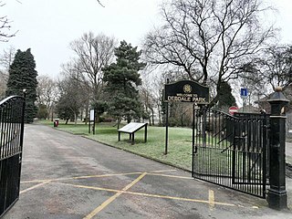
Debdale Park is an inner-city park, located in the Gorton area of Manchester, England. At around 45 acres (18 ha), it is one of the largest inner-city parks in the City of Manchester.

<span class="mw-page-title-main">Burton Road tram stop</span> Manchester Metrolink tram stop

Burton Road is a stop on the South Manchester Line of Greater Manchester's light rail Metrolink system. It is located on Burton Road, on the border of the suburbs of Withington and West Didsbury in Manchester, England.

<span class="mw-page-title-main">Stockport bus station</span> Bus station in Stockport, Greater Manchester, England

Stockport bus station in Stockport, Greater Manchester was a bus terminus for approximately sixty-five bus services. It opened on 2 March 1981 on the site of a former car park. Before the bus station opened, most services terminated at Mersey Square.

<span class="mw-page-title-main">History of Manchester Metrolink</span>

The history of Manchester Metrolink begins with its conception as Greater Manchester's light rail system in 1982 by the Greater Manchester Passenger Transport Executive, and spans its inauguration in 1992 and the successive phases of expansion.

<span class="mw-page-title-main">Cycling in Greater Manchester</span>

Cycling for transport and leisure enjoys popularity in Greater Manchester and the city also plays a major role in British cycle racing. The Bee Network was launched in 2018. The University of Manchester is home to the Manchester Cycling Lab.

<span class="mw-page-title-main">South Manchester Line</span> Manchester Metrolink line

The South Manchester Line (SML) is a tram line of the Manchester Metrolink in Greater Manchester running from Manchester city centre to Didsbury. The line was opened as far as St. Werburgh's Road in 2011 and then to East Didsbury in 2013 as part of phase three of the system's expansion, and runs entirely along a former railway trackbed.

References

  1. "Fallowfield Loopline". Archived from the original on 29 March 2013. Retrieved 30 November 2018.
  2. "Google Maps". Google Maps. Retrieved 30 November 2018.
  3. 1 2 3 Johnson, E. M. (2000). Steam over Woodhead. Book Law Publications. ISBN   9781909625129.
  4. Johnson, E. M. (1993). The Midland route from Manchester. Foxline Publishing. ISBN   9781870119207.
  5. "About the Fallowfield Loop". Friends of the Fallowfield Loop. 13 November 2011. Retrieved 30 November 2018.
  6. "A Brief History of Highfield Country Park". Highfield Country Park. Friends of Highfield Country Park. 15 July 2014. Archived from the original on 15 July 2014. Retrieved 30 November 2018.
  7. "This narrow road has been a nightmare for drivers for too long... plans to widen it have finally been revealed". Manchester Evening News. 29 August 2019. Retrieved 31 August 2019.
  8. "Hyde Road: pinch point widening scheme | Hyde Road: pinch point widening scheme | Manchester City Council". Manchester City Council. Retrieved 31 August 2019.
  9. "The £5m plan to make the Fallowfield Loop more family friendly". Manchester Evening News. 25 July 2020. Retrieved 25 July 2020.
  10. "'There were no toilets, it was just a shell' - look at Levy's old station house now". Manchester Evening News. 29 March 2022. Retrieved 15 November 2022.
  11. "Moment gang of thugs ambush and chase cyclist on the Fallowfield Loop". Manchester Evening News. 7 March 2019. Retrieved 8 March 2019.
  12. "Millions to tackle anti-social behaviour in trouble zones across Greater Manchester". Manchester Evening News. 27 July 2022. Retrieved 15 November 2022.