Wilbraham Road railway station

Last updated

Wilbraham Road
Wilbraham road railway station 1937 OS Map.jpg
1937 OS map showing the location of Wilbraham Road railway station
Location Whalley Range, Manchester, Manchester
England
Coordinates 53°26′24″N2°15′05″W / 53.4401°N 2.2515°W / 53.4401; -2.2515 Coordinates: 53°26′24″N2°15′05″W / 53.4401°N 2.2515°W / 53.4401; -2.2515
Grid reference SJ834937
Platforms2
Other information
StatusDisused
History
Original company Manchester, Sheffield and Lincolnshire Railway
Pre-grouping Great Central Railway
Post-grouping London and North Eastern Railway
Key dates
2 May 1892Station opens as Alexandra Park [1]
1 July 1923Station renamed Wilbraham Road [1] [2]
7 July 1958Station closes [2]

Wilbraham Road railway station was a station in Whalley Range, Manchester, England, on the former Fallowfield Loop line from Manchester Central via Chorlton-cum-Hardy to Fairfield and Guide Bridge. The station was opened as Alexandra Park in 1892 by the Manchester, Sheffield and Lincolnshire Railway. [3]

Contents

It was near the junction of Alexandra Road South and Mauldeth Road West, near Alexandra Park, and served the expanding residential suburb of Whalley Range. The railway line has since been converted into a cycle track.

History

Alexandra Park station opened on 2 May 1892. [1] From 1 August 1897 to 1 January 1923 the station was owned by the Great Central Railway (GCR). The GCR was absorbed by the London and North Eastern Railway (LNER) during the Grouping of 1923. [4] The station was renamed Wilbraham Road on 1 July 1923 to avoid possible confusion with the north London suburb of Alexandra Park on the same network. [2] The naming was an unusual choice, since the station was about a 14 mile (400 m) from the A6010 Wilbraham Road, and was not visible from there.

During 1918–19 the station goods yard was used to receive aircraft fuselages, wings and other major components from Avro at Newton Heath and the National Aircraft Factory No. 2 at Heaton Chapel for assembly at the nearby Alexandra Park Aerodrome, which lay 300 yards (270 m) to the south. [5]

Passenger services on the Fallowfield Loop line were infrequent; the line suffered from competition from alternative rail services into Manchester provided by the LNER from Levenshulme and later from the electric trams. By the 1930s the LNER had greatly reduced the stopping services and mostly used the line for express trains. After 1948, the line was under the ownership of the nationalised British Railways.

The electrification of the line was briefly considered but, instead, the local stopping services were withdrawn and Wilbraham Road station was closed to passenger services by British Railways on 7 July 1958. [2] However, SELNEC PTE continued to run a scheduled motor-bus service from the station, timed according to the now-defunct passenger timetable. Express services out of Manchester Central continued to use the line until that terminus was closed in 1969 following the Beeching cuts. For another two decades the line was used by freight trains until the line closed completely in 1988. [6] Eventually the station buildings were demolished and today only some residual brickwork of the platform edges survives. The sidings at the other side of Alexandra Road South, however, remained in use by SPD Distribution until the line closed. The track bed of the line crosses a road on the former site, and the Station Master's house is still in use as a private residence.

Blues and Gospel Train

On 7 May 1964, Granada Television transformed the disused buildings into Chorltonville, a southern U.S.-style station, for a programme called Blues and Gospel Train with Muddy Waters, Otis Spann, Sonny Terry and Brownie McGhee, Sister Rosetta Tharpe, Rev. Gary Davis and Cousin Joe Pleasant. [7]

Fallowfield Loop Line
BSicon uCONTg.svg
BSicon CONTg.svg
Arrow Blue Up 001.svg Metrolink / to Manchester Piccadilly
BSicon exKBHFa.svg
BSicon HUBaq.svg
BSicon uHST.svg
BSicon HUBeq.svg
BSicon BHF.svg
Manchester Central / Deansgate-Castlefield
BSicon xABZg+l.svg
BSicon umKRZo.svg
BSicon STRr.svg
BSicon CONTgq.svg
BSicon xABZgr.svg
BSicon uHST.svg
Cornbrook
Arrow Blue Left 001.svg Liverpool–Manchester lines
BSicon uSTRc2.svg
BSicon exSTR.svg
BSicon uHST3.svg
Trafford Bar
BSicon uSTR+1.svg
BSicon exSTR.svg
BSicon uSTRc4.svg
BSicon uCONTgq.svg
BSicon uABZgr.svg
Arrow Blue Left 001.svg MSJ&AR/Metrolink to Altrincham
BSicon uHST.svg
BSicon exBHF.svg
Chorlton-cum-Hardy
BSicon uSTRc2.svg
BSicon uHST3.svg
BSicon exSTR.svg
St Werburgh's Road
BSicon uCONT1.svg
BSicon uSTRc4.svg
BSicon exSTR.svg
Arrow Blue LowerLeft 001.svg South District Railway/Metrolink to Didsbury
BSicon exBHF.svg
Wilbraham Road
BSicon exBHF.svg
Fallowfield
BSicon CONTgq.svg
BSicon xKRZu.svg
BSicon CONTfq.svg
BSicon CONTgq.svg
BSicon xKRZu.svg
BSicon CONTfq.svg
BSicon exBHF.svg
Levenshulme South
BSicon exvSHI2gl-.svg
BSicon d.svg
BSicon exvSTR-DST.svg
BSicon d.svg
BSicon exvSHI2g+l-.svg
BSicon d.svg
BSicon CONTgq.svg
BSicon xKRZo.svg
BSicon CONTfq.svg
BSicon exBHF.svg
BSicon CONTg.svg
Hyde Road
Arrow Blue Up 001.svg to Manchester Piccadilly
BSicon exSTR.svg
BSicon BHF.svg
Gorton
BSicon exSTR2.svg
BSicon exSTRl.svg
BSicon exSTRc3.svg
BSicon eABZgr.svg
BSicon exSTRc1.svg
BSicon BHF.svg
BSicon exSTR+4.svg
Fairfield
BSicon SKRZ-Bu.svg
BSicon BHF.svg
Guide Bridge
BSicon CONTf.svg
Arrow Blue Down 001.svg Hope Valley line to Sheffield
 Key 
BSicon exSTRq.svg
Fallowfield Loop line
BSicon STRq.svg
Present National Rail service
BSicon uSTRq.svg
Metrolink

Railways in the area of Chorlton and Withington

Preceding station Disused railways Following station
Chorlton-cum-Hardy   LNER
Manchester, Sheffield and Lincolnshire Railway
Fallowfield Loop
  Fallowfield

Related Research Articles

Fallowfield Human settlement in England

Fallowfield is a suburb of Manchester, England, with a population at the 2011 census of 15,211. Historically in Lancashire, it lies 3 miles (5 km) south of Manchester city centre and is bisected east–west by Wilmslow Road and north–south by Moseley Road and Wilbraham Road. The former Fallowfield Loop railway line, now a cycle path, follows a route nearly parallel with the east–west main road.

Woodside Park tube station London Underground station

Woodside Park is a London Underground station in Woodside Park, north London.

Crouch End railway station

Crouch End railway station is a former station in the Crouch End area of north London. It was located between Stroud Green station and Highgate station on Crouch End Hill just north of its junction with Hornsey Lane. The station building was located on the road bridge over the railway but only small parts remain of the structure today.

Alexandra Palace railway station (1873–1954)

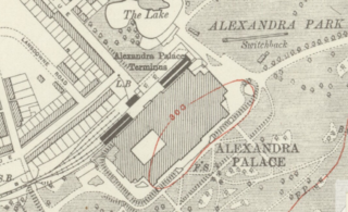
Alexandra Palace is a closed railway station in the grounds of Alexandra Palace in the Muswell Hill area of north London. It is one of a number of stations to have held the name at various times and should not be confused with the current Alexandra Palace station which is on the East Coast Main Line to the east of the closed station.

Achnasheen railway station Railway station in Highland, Scotland

Achnasheen railway station is a remote railway station on the Kyle of Lochalsh Line, serving the village of Achnasheen in the north of Scotland.

Milliken Park railway station

Milliken Park railway station serves the west end of Johnstone and the south west of the village of Kilbarchan in Renfrewshire, Scotland. The station is managed by Abellio ScotRail and is on the Ayrshire Coast Line.

Chorlton tram stop

Chorlton is a stop on the South Manchester Line (SML) and Airport Line of the Metrolink light-rail system in Chorlton-cum-Hardy, Manchester, England. It was built as part of Phase 3a of the network's expansion, and opened on 7 July 2011 on a section of the former Cheshire Lines Committee railway.

Rhu is a closed railway station located in the village of Rhu, in Argyll and Bute, Scotland, on the east shore of Gare Loch. It is located towards the southern end of the West Highland Railway.

Fallowfield railway station Disused railway station in Manchester, England

Fallowfield railway station was on Wilmslow Road in Fallowfield, a southern suburb of Manchester, England. It was on the Fallowfield Loop railway line, a suburban railway which looped around the south of the city and terminated at the former Manchester Central railway station.

Hyde Road railway station

Hyde Road was a railway station in Gorton, Manchester, England, on the Fallowfield Loop Line. It opened in 1892 and closed in 1958 when local passenger services on the line stopped. The station was sometimes advertised as Hyde Road for Belle Vue, that is, convenient for Belle Vue Zoo, about one mile away. The track closed completely in 1988 and the track was taken up. The station has long since been demolished, and the site has now been partly redeveloped. The line of the track is used as a cycleway.

Fallowfield Loop railway line

The Fallowfield Loop railway line was a local railway route in Manchester, England. Trains on the Manchester, Sheffield and Lincolnshire Railway (MS&LR) line from Sheffield Victoria and Guide Bridge used the Loop to access Manchester Central railway station. Some express trains including the Harwich-Sheffield-Manchester-Liverpool boat train used the line.

Hopton-on-Sea was a railway station serving the village of Hopton-on-Sea in Norfolk on the Norfolk and Suffolk Joint Railway line between Great Yarmouth and Lowestoft. It opened in 1903 and closed in 1970.

Aberlady railway station

Aberlady railway station served the village of Aberlady in Scotland. It was served by the Aberlady, Gullane and North Berwick railway. This line diverged from the East Coast Main Line at Aberlady Junction, east of the current Longniddry station.

Arkwright Town railway station Former railway station in Derbyshire, England

Arkwright Town railway station was in Arkwright Town, Derbyshire, England.

Turriff railway station

Turriff railway station was a railway station in Turriff, Aberdeenshire, Scotland. It was opened in 1857 by the Banff Macduff & Turriff Junction Railway, later part of the Great North of Scotland Railway, then the LNER and finally British Railways, on the branchline from Inveramsay to Macduff, the station closed to passengers in 1951 and to goods in 1966. The town lay to the north.

Plaidy railway station

Plaidy railway station was a railway station at Plaidy, Aberdeenshire, Scotland on the rural branchline to Macduff. It was opened in 1860 by the Banff, Macduff and Turriff Junction Railway and closed in 1944. Plaidy was 22 miles (35 km) from the junction at Inveramsay and 245 feet (75 m) above sea level.

St Werburghs Road tram stop

St Werburgh's Road is a tram stop on the South Manchester Line (SML) and Airport Line of Greater Manchester's light-rail Metrolink system in Chorlton-cum-Hardy, Manchester. It was built as part of Phase 3a of the network's expansion and opened on 7 July 2011.

Fallowfield Loop Off-road cycle path, pedestrian and horse riding route in the south of Manchester, England

The Fallowfield Loop is an off-road cycle path, pedestrian and horse riding route in the south of Manchester, England, which is one of the National Cycle Network routes and paths developed and built by Sustrans.

Derry Ormond railway station

Derry Ormond railway station served the hamlet and rural locale of Betws Bledrws near Llangybi, as well as the mansion and estate of Derry Ormond on the Carmarthen Aberystwyth Line in the Welsh county of Ceredigion. Opened in 1867 as Bettws, it was renamed in July 1874 in honour of the local estate, owned by the influential Jones, later Inglis-Jones, family.

West Leigh and Bedford railway station

The West Leigh and Bedford railway station served the hamlet of Crankwood, the village of Abram, and the Plank Lane area of Leigh, England. Like many railways, the line passed between rather than through communities, with branches off to serve the key driver - goods, and in this area - coal.

References

Notes

  1. 1 2 3 Butt 1995 , p. 15
  2. 1 2 3 4 Butt 1995 , p. 250
  3. "Wilbraham Road". Disused Stations. Retrieved 27 March 2013.
  4. Awdry, Christopher, Encyclopedia of British Railway Companies, Guild Publishing, 1990, CN 8983, p. 133
  5. Scholefield, R.A., Manchester's Early Airfields an extended chapter in Moving Manchester, Lancashire & Cheshire Antiquarian Society, 2004, ISSN   0950-4699, p. 216
  6. "Eyewitness in Manchester - South Manchester Loop Line Walk". Archived from the original on 19 July 2008. Retrieved 14 March 2013.
  7. Muddy Waters and Sister Rosetta Tharpe's 'mind-blowing' station show, BBC News, 7 May 2014

Sources

  • Butt, R. V. J. (1995). The Directory of Railway Stations: details every public and private passenger station, halt, platform and stopping place, past and present (1st ed.). Sparkford: Patrick Stephens Ltd. ISBN   978-1-85260-508-7. OCLC   60251199.
  • Jowett, Alan (March 1989). Jowett's Railway Atlas of Great Britain and Ireland: From Pre-Grouping to the Present Day (1st ed.). Sparkford: Patrick Stephens Ltd. ISBN   978-1-85260-086-0. OCLC   22311137.