Didsbury railway station

Last updated

Didsbury
Didsbury Railway Station and clock c.1910.jpg
Didsbury railway station (photographed c.1910)
General information
Location Didsbury, City of Manchester
England
Coordinates 53°25′07″N2°13′53″W / 53.4186°N 2.2313°W / 53.4186; -2.2313
Grid reference SJ847913
Platforms2
Other information
StatusDisused
History
Original company South District Railway
Pre-grouping Midland Railway
Post-grouping London, Midland and Scottish Railway
London Midland Region of British Railways
Key dates
1 January 1880 (1880-01-01)Station opened
2 January 1967 (1967-01-02)Station closed

Didsbury railway station is a former station in Didsbury, in the southern suburbs of Manchester, England, United Kingdom. The station was located on Wilmslow Road, just north of the junction with Barlow Moor Road and opposite Didsbury Library. Nothing now remains of the old station buildings, which have been demolished, but the surviving white Portland stone clock tower is a local landmark. Didsbury is now served by Didsbury Village tram stop which is close to the site of the former railway station.

Contents

History

Midland Railway lines into Manchester showing the Manchester South District Line Midland to Manchester.jpg
Midland Railway lines into Manchester showing the Manchester South District Line
Manchester South District Line
BSicon exKINTa.svg
BSicon unCONTg.svg
BSicon exlDAMPF.svg
Manchester Central
BSicon exSTR.svg
BSicon lINT.svg
BSicon unSTR.svg
Metrolink generic.png
Deansgate-Castlefield ( National Rail logo.svg
BSicon unSTR+l.svg
BSicon exSTR.svg
BSicon unSTRr.svg
BSicon KSTRaq cerulean.svg
BSicon unSTR.svg
BSicon xmKRZo +cerulean.svg
BSicon KSTReq cerulean.svg
BSicon unSTR.svg
BSicon ulHST.svg
BSicon exSTR.svg
Metrolink generic.png
Cornbrook
BSicon undCONTgq.svg
BSicon exdCONTgq.svg
BSicon unSTRr.svg
BSicon unSTR.svg
BSicon exABZgr.svg
BSicon dCONTgq.svg
BSicon unSTR.svg
BSicon MSTRq.svg
BSicon lMKRZu.svg
BSicon STRoq.svg
BSicon exSTR.svg
BSicon dCONTfq.svg
BSicon unSTR.svg
BSicon ulHST.svg
BSicon exSTR.svg
Metrolink generic.png
Trafford Bar
BSicon undCONTgq.svg
BSicon exdCONTgq.svg
BSicon unSTRr.svg
BSicon unSTR.svg
BSicon exABZgr.svg
BSicon unSTR.svg
BSicon ulHST.svg
BSicon exSTR.svg
Metrolink generic.png
Firswood
BSicon ulHST.svg
BSicon unSTR.svg
BSicon exBHF.svg
BSicon exlDAMPF.svg Metrolink generic.png
Chorlton
BSicon unSTR.svg
BSicon ulHST.svg
BSicon exSTR.svg
Metrolink generic.png
St Werburgh's Road
BSicon undCONTgq.svg
BSicon unSTRr.svg
BSicon unSTR.svg
BSicon exSTR.svg
BSicon unSTR.svg
BSicon ulHST.svg
BSicon exSTR.svg
Metrolink generic.png
Withington
BSicon unSTR.svg
BSicon ulHST.svg
BSicon exSTR.svg
Metrolink generic.png
Burton Road
BSicon unSTR.svg
BSicon exBHF.svg
BSicon exlDAMPF.svg
Withington and Albert Park
BSicon unSTR.svg
BSicon ulHST.svg
BSicon exSTR.svg
Metrolink generic.png
West Didsbury
BSicon unSTR.svg
BSicon exBHF.svg
BSicon exlDAMPF.svg
Didsbury
BSicon unSTR.svg
BSicon ulHST.svg
BSicon exSTR.svg
Metrolink generic.png
Didsbury Village
BSicon dCONTgq.svg
BSicon unSTR.svg
BSicon MSTRq.svg
BSicon lMKRZu.svg
BSicon STRoq.svg
BSicon exSTR.svg
BSicon dCONTfq.svg
BSicon unSTR.svg
BSicon ul-BHF.svg
BSicon exSTR.svg
Metrolink generic.png
East Didsbury
BSicon exSTR.svg
BSicon exBHF.svg
BSicon exlDAMPF.svg
Heaton Mersey
BSicon exCONTgq.svg
BSicon exKRZoxl.svg
BSicon exINTq.svg
BSicon exCONTfq.svg
BSicon exlDAMPF.svg
Stockport Tiviot Dale
BSicon WCONTfaq.svg
BSicon exhKRZWae.svg
BSicon WCONTgeq.svg
BSicon exBHF.svg
BSicon exlDAMPF.svg
Cheadle Heath
BSicon dCONTgq.svg
BSicon xKRZu.svg
BSicon dCONTfq.svg
BSicon dCONTgq.svg
BSicon xKRZu.svg
BSicon dCONTfq.svg
BSicon exBHF.svg
BSicon exlDAMPF.svg
Hazel Grove
BSicon exCONTf.svg
Key
BSicon exKBHFa.svg
BSicon exlDAMPF.svg
Former MSDR station (1880–1967)
BSicon unSTR.svg
BSicon exBHF.svg
BSicon exlDAMPF.svg
Metrolink route through former MSDR station (2013–)
BSicon unSTR.svg
BSicon ulHST.svg
BSicon exSTR.svg
Metrolink generic.png
Metrolink stop on former MSDR line (2013–)
BSicon ulHST.svg
BSicon unSTR.svg
BSicon exBHF.svg
BSicon exlDAMPF.svg Metrolink generic.png
Metrolink stop on former MSDR station (2013–)

In 1873, the Manchester South District Railway obtained permission to construct a new railway line from Manchester to Alderley. The company fell into financial difficulty and was eventually bought out by the Midland Railway in 1877, who went on to build the line. Construction began in 1878 and the line — including Didsbury Station — opened to passenger service on 1 January 1880, running from the new Manchester Central Station through south Manchester suburbs to Stockport Tiviot Dale. [1] [2] [3]

The line ran south through Didsbury via a cutting, passing underneath Wilmslow Road. Didsbury Station was situated on the east side of Wilmslow Road, set back from the road with a small forecourt area. The station building was a red brick Gothic Revival house with a booking office, ladies' and gentlemen's waiting rooms and an adjacent station master's house. There were two platforms in the cutting with glass canopies and a footbridge. Didsbury was served initially by the South District Service commuter route, and from August 1880 by express trains running from Manchester Central to London St Pancras. [2] [3]

Didsbury's location on the network ensured frequent services. From 1901 the MR opened a new route to New Mills via Heaton Mersey and peak-time services through Didsbury reached over 38 trains per hour in each direction. Direct services operated between Didsbury and destinations such as Derby, Sheffield Midland and the Peak District. [2] [3]

Around 1910, a memorial clock was erected in the station forecourt dedicated to local philanthropist John Milson Rhodes (1847-1909). The 8-metre (26 ft) clock tower is built of Portland stone in an Edwardian Baroque style and incorporates a pair of drinking fountains. On one side there is a bronze plaque which displays a relief medallion portrait of Rhodes and the inscription "In memory of Dr.J.Milson Rhodes JP.CA. 1847-1909. A Friend to Humanity". [4] [2] [3]

From 1923, the MR was absorbed into the LMS, and after 1948 the line became part of British Rail. In the postwar period, while the South District Service declined in frequency, Manchester Central-London express services increased, although the new Blue Pullmans did not call at Didsbury but at Cheadle Heath instead.

Closure

When the former London & North Western Railway line from Manchester Piccadilly became the principal route for London express trains, the South District Line lost its importance; the route and its stations were listed for closure in the Beeching cuts. The last train to depart from Didsbury was the 18:45 express to London St Pancras on 2 January 1967. Passenger express and freight trains continued to run through Didsbury until the line was fully closed in 1969. [2] [3]

The station building remained standing for a number of years and was used as a hardware store, Didsbury Station Hardware. After the store closed, the building fell derelict and was demolished in 1982. [1] [5] [2] [3]

Line re-opening

The former site of Didsbury Station with the clock on Wilmslow Road Didsbury Station clock .jpeg
The former site of Didsbury Station with the clock on Wilmslow Road

The former South District Line lay derelict for several decades. In 1984, Greater Manchester Council and Greater Manchester Passenger Transport Executive announced the Project Light Rail scheme to develop a new light rail/tram system by re-opening use of disused railway lines in the region, including the route through Didsbury. [6] The first phase of the Manchester Metrolink system opened in 1992, but it was not until 2013 that the network was expanded to reach Didsbury. Tram tracks were laid along the former trackbed, but as Didsbury station had been demolished over 30 years earlier, it was decided to locate the new Didsbury Village tram stop further down the line on School Lane. [7] [2] [3]

Nothing remains today of the old Midland Railway station building, and the site today is occupied by a row of shops and pubs. The station clock is still standing and is a local landmark. [1]

See also

Related Research Articles

<span class="mw-page-title-main">Withington</span> Human settlement in England

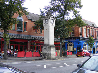
Withington is a suburb of Manchester, Greater Manchester, England. Historically part of Lancashire, it lies 4 miles (6.4 km) from Manchester city centre, about 0.4 miles (0.6 km) south of Fallowfield, 0.5 miles (0.8 km) north-east of Didsbury and also 1 mile (1.6 km) east of Chorlton-cum-Hardy. Withington has a population of just over 14,000 people, reducing at the 2011 census to 13,422.

<span class="mw-page-title-main">Didsbury</span> Suburban village of Manchester

Didsbury is a suburban village in Manchester, Greater Manchester, England, on the north bank of the River Mersey, 5 miles south of Manchester city centre. The population at the 2011 census was 26,788.

<span class="mw-page-title-main">Styal line</span>

The Styal line is a suburban commuter railway line which runs through south Manchester, England; it commences at Slade Lane Junction, 1.2 miles (1.9 km) south of Manchester Piccadilly, and ends 12 miles (19 km) south at Wilmslow.

<span class="mw-page-title-main">Manchester Central railway station</span> Former railway station in England

Manchester Central railway station is a former railway station in Manchester city centre, England. One of Manchester's main railway terminals between 1880 and 1969, it has been converted into an exhibition and conference centre, originally known as G-MEX, but now named Manchester Central. The structure is a Grade II* listed building.

<span class="mw-page-title-main">Rochdale railway station</span> Railway station and tram stop in Greater Manchester, England

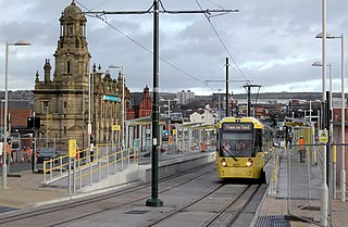
Rochdale railway station is a multi-modal transport hub in Rochdale, Greater Manchester, England. It consists of a Northern-operated heavy rail station on the Caldervale Line, and an adjoining light rail stop on Metrolink's Oldham and Rochdale Line. The original heavy-rail element of the station was opened by the Manchester and Leeds Railway in 1839 0.5 miles (0.80 km) to the south of Rochdale town centre. The Metrolink element opened in February 2013. Further changes to the station are planned as part of the Northern Hub rail-enhancement scheme.

<span class="mw-page-title-main">East Didsbury railway station</span> Railway station in Greater Manchester, England

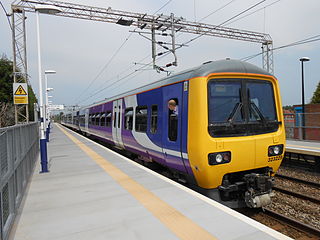
East Didsbury is a suburban railway station in south Manchester, England. On the Styal Line between Longsight and Wilmslow, it is served by Liverpool Lime Street-Manchester Airport and Crewe trains operated by Northern Trains, Llandudno - Manchester Airport services operated by Transport for Wales and some peak Manchester Airport services operated by TransPennine Express.

<span class="mw-page-title-main">Chorlton tram stop</span> Manchester Metrolink tram stop

Chorlton is a stop on the South Manchester Line (SML) and Airport Line of the Metrolink light-rail system in Chorlton-cum-Hardy, Manchester, England. It was built as part of Phase 3a of the network's expansion, and opened on 7 July 2011 on a section of the former Cheshire Lines Committee railway.

<span class="mw-page-title-main">Fallowfield railway station</span> Disused railway station in Manchester, England

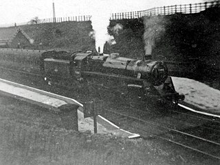
Fallowfield railway station is a disused station that is located on Wilmslow Road in Fallowfield, a southern suburb of Manchester, England. It was on the Fallowfield Loop railway line, a suburban railway which looped around the south of the city and terminated at the former Manchester Central railway station. The station closed to passengers in 1958, but its building still stands on the corner of Wilmslow Road and Ladybarn Road.

<span class="mw-page-title-main">Fallowfield Loop railway line</span> Disused English Railway line

The Fallowfield Loop railway line was a local railway route in south Manchester, England. Trains on the Manchester, Sheffield and Lincolnshire Railway (MS&LR) line from Sheffield Victoria and Guide Bridge used the Loop to access Manchester Central railway station. Some express trains, including the Harwich-Sheffield-Manchester-Liverpool boat train, used the line.

<span class="mw-page-title-main">St Werburgh's Road tram stop</span> Manchester Metrolink tram stop

St Werburgh's Road is a tram stop on the South Manchester Line (SML) and Airport Line of Greater Manchester's light-rail Metrolink system in Chorlton-cum-Hardy, Manchester. It was built as part of Phase 3a of the network's expansion and opened on 7 July 2011.

<span class="mw-page-title-main">West Didsbury tram stop</span> Manchester Metrolink tram stop

West Didsbury is a tram stop on the South Manchester Line (SML) of Greater Manchester's light-rail Metrolink system. It opened to passengers on 23 May 2013, in West Didsbury, South Manchester, England.

<span class="mw-page-title-main">Didsbury Village tram stop</span> Manchester Metrolink tram stop

Didsbury Village is a tram stop on the South Manchester Line on the light-rail Metrolink network in Greater Manchester, England. It serves the South Manchester suburb of Didsbury.

<span class="mw-page-title-main">East Didsbury tram stop</span> Manchester Metrolink tram stop

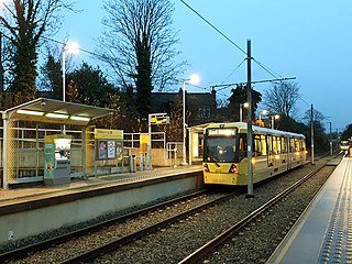
East Didsbury is a tram stop on Greater Manchester's light rail Metrolink system and the terminus of the system's South Manchester Line (SML). It is on the east side of Kingsway in East Didsbury, close to Manchester's boundary with Heaton Mersey in the Metropolitan Borough of Stockport. It was built as part of Phase 3b of the network's expansion and opened on 23 May 2013.

<span class="mw-page-title-main">Withington tram stop</span> Manchester Metrolink tram stop

Withington is a tram stop on the South Manchester Line (SML) of Greater Manchester's light-rail Metrolink system. It is located on the west side of Princess Road on the fringe of Withington in south Manchester, England.

<span class="mw-page-title-main">Burton Road tram stop</span> Manchester Metrolink tram stop

Burton Road is a stop on the South Manchester Line of Greater Manchester's light rail Metrolink system. It is located on Burton Road, on the border of the suburbs of Withington and West Didsbury in Manchester, England.

<span class="mw-page-title-main">Withington and West Didsbury railway station</span> Former railway station in England

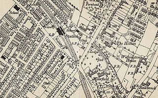
Withington and West Didsbury railway station is a former station in West Didsbury, in the southern suburbs of Manchester, England, United Kingdom. The station was located on Lapwing Lane, close to the junction with Palatine Road and opposite Withington Town Hall. Nothing now remains of the old station buildings, which have been demolished. West Didsbury is now served by West Didsbury tram stop which is approximately 85 metres (279 ft) further down the line from the original railway station.

<span class="mw-page-title-main">South Manchester Line</span> Manchester Metrolink line

The South Manchester Line (SML) is a tram line of the Manchester Metrolink in Greater Manchester running from Manchester city centre to Didsbury. The line was opened as far as St. Werburgh's Road in 2011 and then to East Didsbury in 2013 as part of phase three of the system's expansion, and runs entirely along a former railway trackbed.

<span class="mw-page-title-main">Manchester South District Railway</span> Former British railway operator

The Manchester South District Railway (MSDR) was a British railway company that was formed in 1873. It was formed by a group of landowners and businessmen in the south of Manchester, England, with the purpose of building a new railway line through the city's southern suburbs.

<span class="mw-page-title-main">Oldham and Rochdale Line</span> Manchester Metrolink line

The Oldham and Rochdale Line (ORL) is a tram line of the Manchester Metrolink in Greater Manchester running from Manchester city centre to Rochdale town centre via Oldham, using most of the trackbed of the former Oldham Loop Line which closed in 2009. The line was re-opened in a modified form as a tramway between 2012 and 2014, as part of phase three of the system's expansion.

<span class="mw-page-title-main">Proposed developments of Manchester Metrolink</span> Development of Manchester Metrolink light rail system

This is a list of confirmed or proposed future developments of the Manchester Metrolink light rail system in Greater Manchester, England.

References

Citations

  1. 1 2 3 Sussex, Gay; Helm, Peter (1988). Looking Back at Withington and Didsbury. Timperley: Willow Publishing. pp. inside front cover. ISBN   0-946361-25-8.
  2. 1 2 3 4 5 6 7 "Didsbury Station". www.disused-stations.org.uk. Disused Stations. Archived from the original on 20 May 2020. Retrieved 18 June 2020.
  3. 1 2 3 4 5 6 7 Suggitt 2004.
  4. Historic England. "Rhodes Memorial Clock (1270515)". National Heritage List for England . Retrieved 7 July 2020.
  5. "Didsbury". Disused Stations. Retrieved 18 October 2012.
  6. Ogden, Eric; Senior, John (1991). Metrolink: Official Handbook. Glossop, Derbyshire: Transport Publishing Company. pp. 26–27. ISBN   0-86317-164-8.
  7. Kirby, Dean (23 May 2013). "First passengers travel on tram extension to East Didsbury". Manchester Evening News . Retrieved 18 June 2020.

Sources

Preceding station Historical railways Following station
Withington and West Didsbury
Station closed
  Midland Railway
South District Railway
  Heaton Mersey
Station closed