Golborne South railway station

Last updated

Golborne South
General information
Location Golborne, Wigan
England
Coordinates 53°28′42″N2°35′42″W / 53.478425°N 2.595052°W / 53.478425; -2.595052
Grid reference SJ606981
Platforms2
Other information
StatusDisused
History
Original company North Union Railway
Pre-grouping London and North Western Railway
Post-grouping London, Midland and Scottish Railway
Key dates
by 19 October 1839Station opened as "Golborne Gate"
by 1847Station known as "Golborne"
1 February 1949Renamed "Golborne South"
2 February 1961Station closed to passengers
22 May 1967Station closed completely

Golborne South railway station was one of two stations serving the town of Golborne, to the south of Wigan.

Contents

The early line and station to 1849

The line was opened by the Wigan Branch Railway (WBR) in 1832 from Parkside to Wigan as a single track with passing places although the trackbed had been engineered for double track. [1] In 1834 the WBR became part of the North Union Railway (NUR) and they doubled the track in time for the opening of the line northwards to Preston in 1838. [2]

The line had opened two years after the opening of the Liverpool and Manchester Railway (L&MR) with which it connected at Parkside, it was operated under contract by the L&MR and likely followed L&MR practices. [3] On the L&MR intermediate stopping places were neither advertised nor provided with facilities, they were mostly situated at level crossings where a policeman or gateman was permanently on duty, passengers wishing to use the stopping place informed the staff who signalled the requirement to stop to the train crew, [4] [5]

The WBR had one crossing on the level, at Golborne, 1 mile 72 chains (3.1 km) from Parkside, [lower-alpha 1] [6] where the Warrington to Wigan turnpike crossed the railway at a gated level crossing known as Golborne Gates and this would have been an identified stopping place on the line and therefore may have operated as a station in the same way as on the L&MR. [7] A more formal station was probably opened as Golborne Gate or Gates by the North Union Railway (NUR) probably sometime before 1839 as the station started to appear on the maps in Bradshaw from then, fares to intermediate stations, including Golbourne Gate [sic] were published in 1839. [lower-alpha 2] [9] [11] By 1847 the station was known as Golborne and it appeared in Bradshaw in a route-table with times for the trains shown. There were four services from the station northbound to Preston and southbound to both Liverpool and Manchester on weekdays. [lower-alpha 3] [12] As late as 1849 the OS map shows the level crossing but no station or structure. [13] [14]

From 1 January 1846 the NUR was leased jointly by the Grand Junction Railway (GJR) and the Manchester and Leeds Railway (M&LR). Later in 1846 the leases passed, by amalgamation from the GJR to the London and North Western Railway (L&NWR) and from the M&LR to the Lancashire and Yorkshire Railway. [15] [16]

L&NWR from 1850

The L&NWR replaced the level crossing with a road overbridge carrying High Street/Church Road (which became the A573), on a slightly further north alignment sometime around 1867-68. [lower-alpha 4] The station was rebuilt sometime between the new road being completed and the OS map being issued in 1893. [lower-alpha 5] [7] [19] [20] The station was built on the original lines of the WBR which became the slow lines when the line was quadrupled, the fast lines by-passed the station to the east. The station building was on the east side platform, to the south of the road overbridge which crossed the platforms about half-way along their length. The building was a two-storey brick-built building accessed from the bridge with the booking hall at road level, steps went down to each platform, the west-side platform steps descending from a pedestrian bridge crossing the lines. There was a brick built shelter on each platform. [7] [21]

During the late 1800s more railways opened and traffic increased. [lower-alpha 6] The line through Golborne, as part of the main western trunk route to Scotland, became congested and between 1888 and 1894 the lines through the station site were quadrupled. [7]

There were two signal boxes in the station vicinity one to the south west of the running lines that controlled the goods yard, and one to the north of the eastern platform, between the slow and fast lines, which controlled access to Golborne Colliery. The goods yard had two, later three sidings on the west side of the running lines and a warehouse, it was able to accommodate most types of goods including live stock and was equipped with a five ton crane. [24] [25]

In 1895 there were 11 local services on weekdays in each direction, northbound all going to Wigan and southbound to Warrington except for one service, the 1453, which went to Liverpool Lime Street. [26]

In 1922 thirteen services called at Golborne in each direction on Mondays to Saturdays, most were local services. Northbound they mainly started from Warrington, with two starting from Crewe, two from Liverpool Lime Street and one from Hartford. All went to Wigan, three terminated at Preston and one at Carlisle. Southbound they mostly started from Wigan, the first train, the 0628, began at Preston and the 0710 started from Golborne itself. Destinations were mostly Warrington with two services running short journeys to Earlestown and one going onto Hartford. There were two Sunday services in each direction. [27]

Post L&NWR to station closure

Services under the London, Midland and Scottish Railway (LMS) remained much the same as previously, in 1939 there were 17 services in each direction on weekdays, mostly local trains between Warrington and Wigan with one service from Liverpool, one from Crewe and a few shortened services terminating at Newton-le-Willows, there were slightly less trains on Saturdays and six on Sundays. [28]

The station was renamed Golborne South on 1 January 1949 to avoid confusion with the close by ex-Great Central/LNER Golborne North station. The station closed to passengers on 6 February 1961 and to goods traffic on 22 May 1967. [8] [29]

Post-closure

Local passenger traffic ceased between Crewe and Preston via Earlestown on 6 October 1969. [30]

The lines through the station site were electrified as part of the West Coast Main Line (WCML) modernisation in 1974. [31] [32]

The lines through the station site are still open in 2023. [33] Transport for Greater Manchester announced a public consultation for January 2024 on building a new station on a site to the south of the previous station. [34] No costs were given, although TfGM had in 2021 committed £16m to development and delivery of the station.

Preceding station Historical railways Following station
Wigan Chapel Lane   Wigan Branch Railway
1832 – 1834
  Parkside
Wigan Chapel Lane   North Union Railway
Wigan Branch Railway
1834 – 1838
Amalgamated
  Parkside
Wigan
Station re-sited and renamed
  North Union Railway
Wigan Branch Railway
1838 – 1847
  Parkside
Wigan   London and North Western Railway
North Union Railway
1847 – c1850
Leased line
  North Union Junction
New station
Wigan   London and North Western Railway
North Union Railway
c1850 – 1864
Leased line
  Preston Junction
Station renamed
Wigan   London and North Western Railway
North Union Railway
1864 - 1877
Leased line
  Preston Junction
   Warrington Bank Quay
Winwick cut-off opened
Wigan   London and North Western Railway
North Union Railway
1877 - 1878
Leased line
  Lowton and Preston Junction
Station renamed
   Warrington Bank Quay
Bamfurlong
New station
  London and North Western Railway
North Union Railway
1878 - 1880
Leased line
  Lowton and Preston Junction
   Warrington Bank Quay
Bamfurlong   London and North Western Railway
North Union Railway
1880 - 1889
Leased line
  Lowton
Station renamed
   Warrington Bank Quay
Bamfurlong   London and North Western Railway
1889 - 1923
NUR dissolved
  Lowton
   Warrington Bank Quay
Bamfurlong   London, Midland and Scottish Railway
London and North Western Railway
1923 - 1948
Grouping
  Lowton
   Warrington Bank Quay
Bamfurlong   BR(LMR)
London, Midland and Scottish Railway
1948 - 1949
Nationalisation
  Lowton
   Warrington Bank Quay
Bamfurlong   BR(LMR)
London, Midland and Scottish Railway
1948 - 1949
Station renamed Golborne South
  Lowton
   Warrington Bank Quay
 Current situation 
Bamfurlong
Line open, station closed
 Golborne South
Line open, station closed in 1961
  Lowton
Line open, station closed
   Warrington Bank Quay
Line and station open

Related Research Articles

The Warrington and Newton Railway was a short early railway linking Warrington to the Liverpool and Manchester Railway at Newton, and to pits at Haydock, nearby. It opened in 1831.

The North Union Railway was an early British railway company, operating two main routes, from Parkside to Preston and from Bolton Trinity Street to Preston, all in Lancashire. The northerly part of the routes sharing the line from Euxton to Preston.

<span class="mw-page-title-main">Wigan North Western railway station</span> One of two railway stations in Wigan, Greater Manchester, England

Wigan North Western railway station is one of two railway stations serving the town centre of Wigan, Greater Manchester, England.

<span class="mw-page-title-main">Wigan Wallgate railway station</span> Railway station in Greater Manchester, England

Wigan Wallgate railway station is one of two railway stations serving the town centre of Wigan in Greater Manchester, England. The station serves two routes, the Manchester-Southport Line and the Manchester-Kirkby Line. It is 16 miles north-west of Manchester Victoria. The station is managed by Northern Trains, who operate all trains serving it.

<span class="mw-page-title-main">Newton-le-Willows railway station</span> Railway station in Newton-le-Willows, Merseyside

Newton-le-Willows railway station is a railway station in the town of Newton-le-Willows, in the Metropolitan Borough of St Helens, and at the edge of the Merseytravel region. The station is branded Merseyrail. The station is situated on the northern route of the Liverpool to Manchester Line, the former Liverpool and Manchester Railway which opened in 1830. It is a busy feeder station for nearby towns which no longer have railway stations, such as Golborne, Billinge and Haydock. There is also a complimentary bus shuttle service to Haydock Park Racecourse on certain racedays.

Longton Bridge was a railway station on the West Lancashire Railway in England. It served the village of Longton.

<span class="mw-page-title-main">Wigan Central railway station</span> Former railway station in England

Wigan Central railway station was a railway station near the centre of Wigan, Lancashire, England.

<span class="mw-page-title-main">Hindley South railway station</span> Former railway station in England

Hindley South railway station served the communities of Hindley and Platt Bridge, south-east of Wigan, England.

Ashton-in-Makerfield railway station was a railway station serving the town of Ashton-in-Makerfield, although it was located in the neighbouring village of Haydock, formerly in Lancashire, England.

<span class="mw-page-title-main">Old railway lines in Wigan</span>

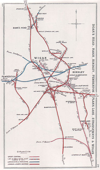
The railway system in Wigan started development in the 19th century during the Industrial Revolution. The first railway built in the town was the Wigan Branch Railway which was opened on 3 September 1832 to serve the many collieries in the area; this was a branch line of the Liverpool and Manchester Railway, the first inter-city railway. By the turn of the 20th century, Wigan had numerous railway stations widely available across the borough, used by both freight and passengers. Many of the lines were originally built for freight which were later converted, as the owners saw the profitability of allowing passengers, to carry passenger trains.

Leigh was a railway station in Bedford, Leigh, Greater Manchester, England, United Kingdom, on the London and North Western Railway. Leigh was in the historic county of Lancashire. Its station opened as Bedford Leigh in 1864, was renamed Leigh & Bedford in 1876 and Leigh in 1914. The station closed in 1969.

<span class="mw-page-title-main">St Helens Central railway station (Great Central Railway)</span> Former railway station in England

St Helens Central (GCR) railway station served the town of St Helens, England with passenger traffic between 1900 and 1952 and goods traffic until 1965. It was the terminus of a branch line from Lowton St Mary's.

Parkside railway station was an original station on the Liverpool and Manchester Railway. It then became the interchange station between lines when the Wigan Branch Railway opened in 1832, moving to the physical junction of the two lines in 1838. The station continued as an interchange until being by-passed in 1847 when a west curve was opened to facilitate north–south links that did not go through the station. Traffic declined further after the Winwick cut-off opened in 1864 leading to closure in 1878.

<span class="mw-page-title-main">Golborne North railway station</span> Former railway station in North-West England

Golborne North railway station served the town of Golborne, in the Metropolitan Borough of Wigan, Greater Manchester, England.

<span class="mw-page-title-main">Lower Ince railway station</span> Former railway station in England

Lower Ince railway station was a railway station in southern Wigan, Lancashire, England.

<span class="mw-page-title-main">Lowton railway station</span> Former railway station in England

Lowton railway station served the village named Town of Lowton to the east of Newton-le-Willows and south of Golborne.

<span class="mw-page-title-main">Bamfurlong railway station</span> Disused railway station in Bamfurlong, Wigan

Bamfurlong railway station served the village of Bamfurlong part of Abram, to the south of Wigan.

The Wigan Branch Railway was a short-lived early British railway company, formed in 1830 and operating from 1832 to 1834 in Lancashire. It was constructed to link Wigan and the surrounding coalfield to the Liverpool and Manchester Railway (L&MR). It was involved in the first parliamentary approved amalgamation of railways to become part of the North Union Railway. Most of the line eventually became part of the West Coast Main Line (WCML).

The Kenyon and Leigh Junction Railway (K&LJR) was constructed to link the Bolton and Leigh Railway (B&LR), which terminated at the Leigh Branch of the Leeds and Liverpool Canal, with the Liverpool and Manchester Railway (L&MR) at Kenyon.

Wigan Chapel Lane railway station served the town of Wigan in Lancashire, England.

References

Notes

  1. Railways in the United Kingdom are, for historical reasons, measured in miles and chains. A chain is 22 yards (20 m) long, there are 80 chains to the mile.
  2. Gate according to Quick (2022), but labelled Gates in Bradshaw (1839 - 1844) [8] [9] [10]
  3. There were some connections available to Birmingham and London that utilised some train re-organisation, see Lowton for details.
  4. Authority to do so was obtained under an act of Parliament, the London and North Western Railway (New Works and Additional Powers) Act 1867 (30 & 31 Vict. c. cxliv). [17]
  5. No evidence ha been found of an opening date. It is likely that it opened on 1 April 1878, the same date as Bamfurlong a little further along the line as the construction of their main buildings is very similar, the Bamfurlong opening is documented. [18]
  6. For example, on the L&NWR freight traffic increased from 9 million to 35 million tons per year between 1865 and 1900, much of it on the main line. [22] Passenger numbers increased considerably around this time as the population became more mobile, see Simmons (1995) for example. [23]

Citations

  1. Sweeney 2008, p. 11.
  2. Sweeney 2008, p. 14.
  3. "Opening of the Wigan Branch Railway" . Preston Chronicle. 25 August 1832. p. 1. Retrieved 20 August 2020 via British Newspaper Archive.
  4. Biddle & Spence 1977, p. 7.
  5. Thomas 1980, p. 128.
  6. "Engineer's Line Reference CGJ5 Carlisle Grand Junction Line (WCML Crewe to Carlisle) including Golborne station". Railway Codes. 27 February 2020. Retrieved 9 September 2020.
  7. 1 2 3 4 Sweeney 2008, p. 37.
  8. 1 2 Quick 2022, p. 212.
  9. 1 2 Bradshaw 1839, p. 15.
  10. Bradshaw 1843, p. 44.
  11. Reed 1969, p. 55.
  12. Bradshaw 1847, p. 33.
  13. "Golborne and Golborne Gates on OS Six-inch map Lancashire CII (includes: Golborne; Leigh.)". National Library of Scotland. 1849. Retrieved 19 August 2020.
  14. Sweeney 2008, pp. 11 & 38.
  15. Greville 1981, p. 11.
  16. Casserley 1968, pp. 143–146.
  17. "Local Act, 30 & 31 Victoria I, c. cxliv:An Act for conferring additional Powers on the London and North-western Railway Company in relation to their own Undertaking and the Undertakings of other Companies; and for other Purposes". UK Parliament Parliamentary Archives. UK Parliament. 1867. Retrieved 8 September 2020.
  18. Quick 2022, p. 65.
  19. Smith & Turner 2012, Map 45.
  20. "Golborne station on OS 25 inch map Lancashire CII.9 (Golborne)". National Library of Scotland. 1893. Retrieved 8 September 2020.
  21. Pixton 1999, p. 29.
  22. Biddle 1997, p. 332.
  23. Simmons 1995, pp. 316–317.
  24. Sweeney 2008, pp. 36 & 40.
  25. The Railway Clearing House 1970, p. 231.
  26. Bradshaw 2011, p. 328.
  27. Bradshaw 1985, pp. 412–5.
  28. LMS Railway 1939, table 61.
  29. Clinker 1978, p. 55.
  30. Hurst 1992, p. 60 (ref 2685).
  31. British Railways Board 1968, p. 83.
  32. British Railways Board 1974.
  33. Network Rail. "Table T051-F Scotland, The North East, North West England - The South West and South Coast" (PDF). Network Rail. Retrieved 24 August 2020.
  34. "A new rail station for Golborne" . Retrieved 26 December 2023.

Sources

Further reading