
The Metropolitan Borough of Tameside is a metropolitan borough of Greater Manchester in North West England. It is named after the River Tame, which flows through the borough and spans the towns of Ashton-under-Lyne, Audenshaw, Denton, Droylsden, Dukinfield, Hyde, Mossley and Stalybridge plus Longdendale. Its western border is approximately 4 miles (6.4 km) east of Manchester city centre. It borders High Peak in Derbyshire to the east, the Metropolitan Borough of Oldham to the north, the Metropolitan Borough of Stockport to the south, and the City of Manchester to the west. As of 2011 the overall population was 219,324.

Ashton-under-Lyne is a market town in Tameside, Greater Manchester, England. The population was 45,198 at the 2011 census. Historically in Lancashire, it is on the north bank of the River Tame, in the foothills of the Pennines, 6.2 miles (10.0 km) east of Manchester.

Droylsden is a town in Tameside, Greater Manchester, England, 4.1 miles (6.6 km) east of Manchester city centre and 2.2 miles (3.5 km) west of Ashton-under-Lyne, with a population at the 2011 Census of 22,689.
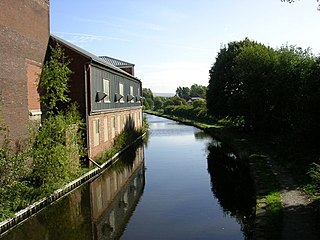
The Ashton Canal is a canal in Greater Manchester, England.

The Huddersfield line is the main railway line between the English cities of Leeds and Manchester via Huddersfield. It is one of the busiest MetroTrain lines. Regional services are operated on the line by TransPennine Express and local services by Northern.
The Ashton, Stalybridge and Liverpool Junction Railway was opened in 1846 to connect the industrial town of Ashton-under-Lyne to the developing railway network, and in particular to the port of Liverpool. It was a short line, joining the Manchester and Leeds Railway at Miles Platting and the connection to Liverpool was over that line and the Liverpool and Manchester Railway.

The Manchester and Leeds Railway was a British railway company that built a line from Manchester to Normanton where it made a junction with the North Midland Railway, over which it relied on running powers to access Leeds. The line followed the valley of the River Calder for much of the way, making for easier gradients but by-passing many important manufacturing towns. Crossing the watershed between Lancashire and Yorkshire required a long tunnel. The line opened throughout in 1841.
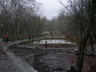
The Hollinwood Branch Canal was a canal near Hollinwood, in Oldham, England. It left the main line of the Ashton Canal at Fairfield Junction immediately above lock 18. It was just over 4.5 miles (7.2 km) long and went through Droylsden and Waterhouses to terminate at Hollinwood Basin. It rose through four locks at Waterhouses (19–22) and another four at Hollinwood (23–26). Immediately above lock 22 at Waterhouses was Fairbottom Junction where the Fairbottom Branch Canal started. Beyond Hollinwood Basin there was a lock free private branch, known as the Werneth Branch Canal, to Old Lane Colliery, which opened in 1797. It is a biological Site of Special Scientific Interest and a Local Nature Reserve.

Hollinwood is an area and electoral ward of the Metropolitan Borough of Oldham, Greater Manchester, England. The population at the 2011 census was 10,920.

Denton railway station is in Denton, Greater Manchester, England, on the Stockport–Stalybridge line. It is served by two trains a week, one in each direction on Saturday mornings.

Stalybridge railway station serves Stalybridge, Greater Manchester. It lies on the Huddersfield Line, 7 1⁄2 miles (12.1 km) east of Manchester Piccadilly and 8 1⁄4 miles (13.3 km) east of Manchester Victoria. The station is managed by TransPennine Express.

Ashton-under-Lyne railway station serves Ashton-under-Lyne, in Greater Manchester, England. It lies on the Huddersfield Line 6½ miles (10 km) east of Manchester Victoria and is operated by Northern.

Guide Bridge railway station serves Guide Bridge in Audenshaw, Greater Manchester, England, and is operated by Northern Trains. The station is 4 3⁄4 miles (7.6 km) east of Manchester Piccadilly on both the Rose Hill Marple and Glossop Lines.

Park railway station served the Newton Heath and Philips Park areas of Manchester, England.

Saxon Mill, Droylsden was a cotton spinning mill in Droylsden, Tameside, Greater Manchester, England. It was built in the 1907, taken over by the Lancashire Cotton Corporation in the 1930s and passed to Courtaulds in 1964. Production finished in 1967, and the mill was demolished in 1995.

Stalybridge Mill, Stalybridge is a cotton spinning mill in Stalybridge, Tameside, Greater Manchester, England. It was built in 1868, and the engine reconfigured in around 1925. It was taken over by the Lancashire Cotton Corporation in the 1930s and passed to Courtaulds in 1964.

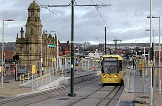
The East Manchester Line (EML) is a tram line of the Manchester Metrolink in Greater Manchester, England, running from Manchester to Ashton-under-Lyne via Droylsden and Audenshaw. The line opened in 2013 as part of phase three of the system's expansion.
The Oldham and Rochdale Line (ORL) is a tram line of the Manchester Metrolink in Greater Manchester running from Manchester city centre to Rochdale town centre via Oldham, using most of the trackbed of the former Oldham Loop Line which closed in 2009. The line was re-opened in a modified form as a tramway between 2012 and 2014, as part of phase three of the system's expansion.
