Kiveton Park is a village within the Metropolitan Borough of Rotherham, in South Yorkshire, England. Historically a part of the West Riding of Yorkshire, from the Norman conquest to 1868, Kiveton was a hamlet of the parish of Harthill-with-Woodall. It subsequently transferred to the civil parish of Wales which takes its name from the neighbouring village.

Easington Colliery is a village in County Durham, England, known for a history of coal mining. It is situated to the north of Horden, a short distance to the east of Easington. It had a population of 4,959 in 2001, and 5,022 at the 2011 Census.
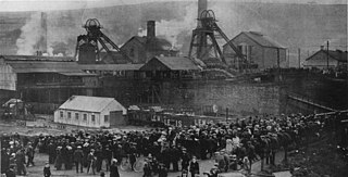
The Senghenydd colliery disaster, also known as the Senghenydd explosion, occurred at the Universal Colliery in Senghenydd, near Caerphilly, Glamorgan, Wales, on 14 October 1913. The explosion, which killed 439 miners and a rescuer, is the worst mining accident in the United Kingdom. Universal Colliery, on the South Wales Coalfield, extracted steam coal, which was much in demand. Some of the region's coal seams contained high quantities of firedamp, a highly explosive gas consisting of methane and hydrogen.

The Oaks explosion, which happened at a coal mine in West Riding of Yorkshire on 12 December 1866, remains the worst mining disaster in England. A series of explosions caused by firedamp ripped through the underground workings at the Oaks Colliery at Hoyle Mill near Stairfoot in Barnsley killing 361 miners and rescuers. It was the worst mining disaster in the United Kingdom until the 1913 Senghenydd explosion in Wales.

Meden Vale is a small former coal mining village originally known as Welbeck Colliery Village prior to renaming in the late 1960s.

Orgreave Colliery was a coal mine situated adjacent to the main line of the Manchester, Sheffield & Lincolnshire Railway about 5 miles (8 km) east of Sheffield and 3.5 miles (6 km) south west of Rotherham. The colliery is within the parish of Orgreave, from which it takes its name.
Rother Vale Collieries were a group of coal producing pits originally in the Rother Valley parishes of Treeton, Woodhouse and Orgreave, nowadays on the south east Sheffield / Rotherham boundary, in South Yorkshire, England. In the early 20th century a new colliery at Thurcroft was developed.

Kiveton Park Colliery was a coal mine in the village of Kiveton Park, near Rotherham, South Yorkshire, England.

Barnburgh Main Colliery was a coal mine situated on the outskirts of the village of Barnburgh, about two miles north of Mexborough in the Dearne Valley, South Yorkshire, England. The sinking of the colliery was commenced in 1911 by the Manvers Main Colliery Company of Wath-upon-Dearne.
Warren Vale Colliery was a coal mine, also known as Piccadilly Colliery, situated alongside Warren Vale Road, between Rawmarsh and Swinton, South Yorkshire, England, in the valley of the Collier Brook, which runs east, for about two miles towards Kilnhurst.
The Elsecar Collieries were the coal mines sunk in and around Elsecar, a small village to the south of Barnsley in what is now South Yorkshire, but was traditionally in the West Riding of Yorkshire.
The South Yorkshire Coalfield is so named from its position within Yorkshire. It covers most of South Yorkshire, West Yorkshire and a small part of North Yorkshire. The exposed coalfield outcrops in the Pennine foothills and dips under Permian rocks in the east. Its most famous coal seam is the Barnsley Bed. Coal has been mined from shallow seams and outcrops since medieval times and possibly earlier.
Aston Colliery was a small coal mine sunk on Aston Common, within Rotherham Rural District but six miles east of Sheffield in the 1840s. In 1864 its workings were taken over and developed by the North Staveley Colliery Company, part of the Staveley Coal and Iron Company, based in North Derbyshire. It was later acquired by the Sheffield Coal Company.
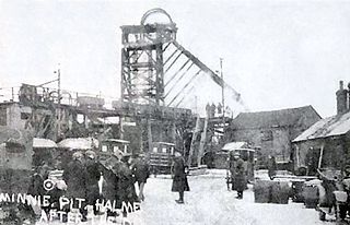
The Minnie Pit disaster was a coal mining accident that took place on 12 January 1918 in Halmer End, Staffordshire, in which 155 men and boys died. The disaster, which was caused by an explosion due to firedamp, is the worst ever recorded in the North Staffordshire Coalfield. An official investigation never established what caused the ignition of flammable gases in the pit.
Albion Colliery was a coal mine in South Wales Valleys, located in the village of Cilfynydd, one mile north of Pontypridd.

Astley Green Colliery was a coal mine in Astley, Greater Manchester, then in the historic county of Lancashire, England. It was the last colliery to be sunk in Astley. Sinking commenced in 1908 by the Pilkington Colliery Company, a subsidiary of the Clifton and Kersley Coal Company, at the southern edge of the Manchester Coalfield, working the Middle Coal Measures where they dipped under the Permian age rocks under Chat Moss. The colliery was north of the Bridgewater Canal. In 1929 it became part of Manchester Collieries, and in 1947 was nationalised and integrated into the National Coal Board. It closed in 1970, and is now Astley Green Colliery Museum.
Manvers Main Colliery was a coal mine, sunk on land belonging to the Earl Manvers on the northern edge of Wath-upon-Dearne, between that town and Mexborough in the Dearne Valley, in the West Riding of Yorkshire, England. The regional headquarters and laboratories of British Coal were situated in the complex.

The Lundhill Colliery explosion was a coal mining accident which took place on 19 February 1857 in Wombwell, Yorkshire, UK in which 189 men and boys aged between 10 and 59 died. It is one of the biggest industrial disasters in the country's history and it was caused by a firedamp explosion. It was the first disaster to appear on the front page of the Illustrated London News.

The Burnley Coalfield is the most northerly portion of the Lancashire Coalfield. Surrounding Burnley, Nelson, Blackburn and Accrington, it is separated from the larger southern part by an area of Millstone Grit that forms the Rossendale anticline. Occupying a syncline, it stretches from Blackburn past Colne to the Yorkshire border where its eastern flank is the Pennine anticline.
Hapton Valley Colliery was a coal mine on the edge of Hapton near Burnley in Lancashire, England. Its first shafts were sunk in the early 1850s and it had a life of almost 130 years, surviving to be the last deep mine operating on the Burnley Coalfield.