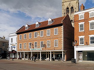
Newark-on-Trent or Newark is a market town and civil parish in the Newark and Sherwood district in Nottinghamshire, England. It is on the River Trent, and was historically a major inland port. The A1 road bypasses the town on the line of the ancient Great North Road. The town's origins are likely to be Roman, as it lies on a major Roman road, the Fosse Way. It grew up round Newark Castle, St Mary Magdalene church and later developed as a centre for the wool and cloth trades.

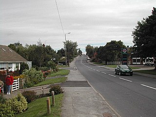
Ollerton is a town and former civil parish, now in the parish of Ollerton and Boughton, in the Newark and Sherwood district, in the county of Nottinghamshire, England, on the edge of Sherwood Forest in the area known as the Dukeries. The population of Ollerton and Boughton at the 2011 census was 9,840.

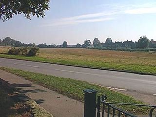
Newark and Sherwood is a local government district in Nottinghamshire, England. It is the largest district by area in the county. The council is based in Newark-on-Trent, the area's largest town. The district also includes the towns of Southwell and Ollerton along with a large rural area containing many villages. Much of the district lies within the ancient Sherwood Forest and there are also extensive forestry plantations in the area.

Newark is a constituency in Nottinghamshire, England. It is currently represented by Robert Jenrick of the Conservative Party who won the seat in a by-election on 5 June 2014, following the resignation of Patrick Mercer in April 2014.
Harby is a village and civil parish in the Newark and Sherwood district of Nottinghamshire, England. It is close to the Lincolnshire border with Doddington. According to the 2011 census, it had a population of 336, up from 289 at the 2001 census.

Balderton is a village and civil parish in Nottinghamshire, England, which had a population of 9,757 at the 2011 census, increasing to 9,917 at the 2021 census.

Barnby in the Willows is a village and civil parish in the Newark and Sherwood district of Nottinghamshire, England, just east of Newark-on-Trent. According to the 2001 census it had a population of 244, increasing to 272 at the 2011 census, with a reduction to 255 at the 2021 census. Just to the south of the village is the River Witham, which also forms the border with Lincolnshire here.
Bilsthorpe is a village and civil parish in the Newark and Sherwood district of Nottinghamshire, England. According to the 2001 census it had a population of 3,076, increasing to 3,375 at the 2011 census, and dropping slightly to 3,365 at the 2021 census. It is located near the junction of the A614 and A617, around 5 miles south of Ollerton, 9 miles east of Mansfield and 6 miles north-west of Southwell.

Clipstone is a former mining village in the Newark and Sherwood district of Nottinghamshire, England. The population of the civil parish was 3,469 at the 2001 census, increasing to 4,665 at the 2011 census, and substantially more so to 6,185 at the 2021 census.
Egmanton is a small village and civil parish in Nottinghamshire, England, and is located one mile south of Tuxford and one mile north of Laxton. According to the 2001 census it has 254 inhabitants in 101 households in the civil parish, the population taken at the 2011 census went up to 286, and this fell to 271 for the 2021 census. The name derives from the Old English words for Ecgmund's farm/settlement.

Farndon is a small village and civil parish in Newark and Sherwood district of Nottinghamshire, England. It lies along the historic Fosse road on the banks of the River Trent and is 3 miles (4 km) south-west of Newark-on-Trent. The population of the civil parish as of the 2011 census was 2,405, this increased to 2,479 at the 2021 census. The A46 road previously ran through the village until the development of a new dual carriageway bypass.
Upton is a small village in Nottinghamshire, England, 2 miles (3.2 km) east of Southwell, 5 miles (8.0 km) west of Newark and 3 miles (4.8 km) south of Hockerton; it lies on the A612 Nottingham-Newark road. In 1889, the village was described as sitting on a bend in the main road, "on the summit of a hill which commands a fine view of the Trent Valley.... The church, which is a prominent feature in the landscape, has a substantial Perpendicular tower crowned by eight pinnacles, and having in the centre a lofty master pinnacle which rises above its neighbours, and so adds materially to the effect."

Hawton is an English village and civil parish in Nottinghamshire, about two miles (3.2 km) south of town of Newark-on-Trent, near the River Devon, a tributary of the River Trent. Its population was recorded as 147 in the 2011 Census.

Carlton-on-Trent is a small village and civil parish in England, located between the River Trent and the A1 road near Newark-on-Trent in Nottinghamshire. The population of the civil parish was 228 at the 2001 census, increasing only marginally to 229 at the 2011 census and similarly to 230 at the 2021 census.
Kelham is a small village and civil parish in Nottinghamshire about 3 miles (4.8 km) northwest of Newark on a bend in the A617 road near its crossing of the River Trent. The population of the civil parish taken at the 2011 census was 207.

Caunton is a village and civil parish in the Newark and Sherwood district of Nottinghamshire on the A616, six miles (9.7 km) north-west of Newark-on-Trent, in the NG23 postcode. The population of the civil parish at the 2011 census was 483, and this increased to 508 at the 2021 census.
Kirklington is a village and civil parish in the Newark and Sherwood district of Nottinghamshire, England. The population as of the 2011 census was 400. Kirklington lies on the A617 road between Newark and Mansfield.
Kneesall is a village and civil parish in the East Midlands of England in the county of Nottinghamshire. The population of the civil parish at the 2011 census was 221. Forming part of the Newark and Sherwood district, Kneesall is situated on the A616 between Newark-on-Trent and Ollerton. The village is three miles from neighbouring Eakring and four miles from Laxton.

Coddington is an English village and civil parish in Nottinghamshire, 3 miles (4.8 km) east of Newark-on-Trent. According to the 2001 census it had a population of 972, which increased to 1,684 at the 2011 Census and to 1,538 at the 2021 census.

Warsop is a town and civil parish in Mansfield District, Nottinghamshire, England, on the outskirts of the remnants of Sherwood Forest. At the 2021 census the population was 12,644 resaidents, including Church Warsop, Meden Vale, Sookholme and Spion Kop.


