History
Colonel William Light's survey teams worked south from Adelaide throughout 1838 and 1839, leaving various marks across the landscape. One such mark was a trig point or flagstaff that was left at a grid reference of 783 192. By 1842, the area near this trig point was called the Flagstaff.
During the late nineteenth century, the Flagstaff was located in a farming and grazing region. In the 1960s, some of the land near the Flagstaff had been earmarked for suburban development.
In 1960, Hooker Rex Estates began purchasing land in the region for subdivision and over the next decade had accumulated nearly two hundred hectares. Blocks were first subdivided in the vicinity of a golf course, planners also provided an oval and recreation facilities. The first 130 blocks were released in April 1967 and sold rapidly. By 1984, all developed land had been sold.
From 1985 the suburb was extended when a portion of Minda Home's Craigburn Farm was subdivided by Essington Ltd. This division was spoken of as 'landmark residential development', due to the retention of large trees and waterways and subdivisions that fitted with the shape and orientation of the land.
The population of Flagstaff Hill was 9,950 in the 2016 census. [4]

Onkaparinga River National Park is a protected area in the Australian state of South Australia located about 32 kilometres (20 mi) south of Adelaide city centre. It extends over the floodplain of the Onkaparinga River east of Main South Road.

Onkaparinga River Recreation Park is a protected area occupying land in the estuary of the Onkaparinga River in South Australia. The recreation park which was established in 1985 is approximately 32 km (20 mi) from Adelaide city centre. It is the venue for recreational activities such as walking, canoeing, kayaking, recreational fishing and picnics.

The City of Onkaparinga is a local government area (LGA) located on the southern fringe of Adelaide, South Australia. It is named after the Onkaparinga River, whose name comes from Ngangkiparinga, a Kaurna word meaning women's river. It is the largest LGA in South Australia, with a population of over 170,000 people in both urban and rural communities and is also geographically expansive, encompassing an area of 518.3 km². The council is headquartered in the Noarlunga Centre with area offices situated in Aberfoyle Park, Woodcroft and Willunga.
Grange is a coastal suburb of the City of Charles Sturt, in Adelaide, South Australia, located about 11 kilometres (6.8 mi) from the Adelaide city centre. The suburb is named after Captain Charles Sturt's cottage, built in 1840–41, which still stands and is now a museum. In addition to Grange Beach, the suburb has several parks and reserves, as well as the Grange Hotel, which was originally licensed in 1881.
West Beach is a seaside suburb of Adelaide, South Australia. It is located in both the City of Charles Sturt and the City of West Torrens.

Clarendon is a small town in the Adelaide Hills, about 25–30 kilometres (16–19 mi) south of the Adelaide city centre and now regarded as an outer suburb of Adelaide. It lies within the City of Onkaparinga council area. The Clarendon Weir is located in the town area, on the Onkaparinga River.

Aberfoyle Park is a suburb in the City of Onkaparinga in the state of South Australia. It is located in the southern suburbs of Adelaide, approximately 20 km from the city centre. Aberfoyle Park has a shopping mall called "The Hub", several primary schools and a public high school, one of the biggest in the state.

Old Noarlunga is a suburb in the Australian state of South Australia located about 30 kilometres (19 mi) south of the state capital of Adelaide. Originally settled around 1840, the town retains its village atmosphere in spite of encroaching suburbia.

Tapleys Hill Road is a section of the north–south arterial road which runs parallel to the coast through western Adelaide, Australia. This entire allocation is best known as by the names of its constituent parts: Tapleys Hill Road proper, Brighton Road, Ocean Boulevard, Lonsdale Road, Dyson Road, Murray Road, and Gawler Street. This article deals with the entire length of the corridor for sake of completion, as well to avoid confusion between declarations. The section Tapleys Hill Road is a remnant of an historic road, and no longer runs to the geographic feature Tapleys Hill.
Coromandel Valley is a semirural south-eastern suburb of Adelaide, South Australia. It straddles the City of Mitcham and the City of Onkaparinga council areas, with the Sturt River being the boundary between the two council areas.

Minda Incorporated, established in 1898, provides support to children and adults with disability in Adelaide, South Australia and is the largest non-Government disability support organisation in the state.

Craigburn Farm is a suburb of Adelaide, South Australia, Australia. It is located about 17 km by road south of the city centre.
Bellevue Heights is a suburb in the City of Mitcham local government area. It was originally the rural property of "Windsor Farm" and later "Sturtbrae" when owned by the family of W. G. Mills, and was named after Bellevue in Sydney by the developer Murray Hill.
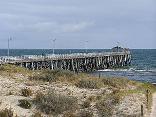
Port Noarlunga South is a suburb in the Australian state of South Australia located in the Adelaide metropolitan area on the coastline of Gulf St Vincent about 30 kilometres south of the state capital of Adelaide.
The Sturt Gorge Recreation Park is a protected area in the Australian state of South Australia located in the suburbs of Bellevue Heights, Craigburn Farm and Flagstaff Hill within the Adelaide metropolitan area about 13 kilometres (8.1 mi) south of the Adelaide central business district.
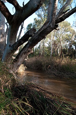
The Sturt River, also known as the Sturt Creek and Warri Parri (Warriparri) in the Kaurna language, is a river located in the Adelaide region of the Australian state of South Australia.
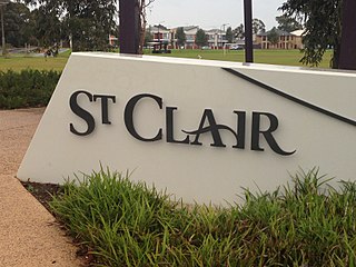
St Clair is a suburb of Adelaide, South Australia, and administered by the City of Charles Sturt. St Clair is geographically located with in the Hundred of Yatala, and was first recorded as the name for the suburb on 6 November 2012 by the Surveyor General of South Australia. The suburb is bounded by Cheltenham Parade, Torrens Road, Woodville Road and the Outer Harbor train line. The Cheltenham Park Racecourse was located here up until the late 2000s and new houses were built in the years after that.
The District Council of Willunga, was a local government area in South Australia seated at Willunga from 1853 until 1997.

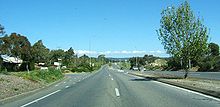
Flagstaff Road is an arterial road in the southern suburbs of Adelaide in South Australia, Australia. It is one of the roads that carries commuter traffic between the city on the coastal plain and residential suburbs in the Adelaide Hills.