
The City of Onkaparinga is a local government area (LGA) located on the southern fringe of Adelaide, South Australia. It is named after the Onkaparinga River, whose name comes from Ngangkiparinga, a Kaurna word meaning women's river. It is the largest LGA in South Australia, with a population of over 170,000 people in both urban and rural communities and is also geographically expansive, encompassing an area of 518.3 km². The council is headquartered in the Noarlunga Centre with area offices situated in Aberfoyle Park, Woodcroft and Willunga.

Aldinga is a suburb of Adelaide in South Australia located about 45 kilometres south of the Adelaide city centre in the City of Onkaparinga. it is a small suburb, about a kilometre east of the edge of the larger suburb of Aldinga Beach, and about 3 km (1.9 mi) from the beachfront.

Flagstaff Hill is a suburb in the City of Onkaparinga local government area. It is named after the hill by that name in the area, where Colonel William Light erected a flagstaff during his survey, which was then used as a trig point. Flagstaff Hill is a leafy suburb established around the Sturt Gorge Recreation Park, maintaining many parks and reserves throughout the suburb.

Darlington is a suburb of Adelaide, South Australia part of which is in the City of Onkaparinga and the City of Marion. For many years, Darlington was the southern entrance to Adelaide's urban area on Main South Road. It hosted many service stations of different brands. It represents the convergence of Flagstaff Road to Main South Road from the south, with Seacombe Road to the west, Diagonal Road to the northwest and Marion Road to the north with South Road continuing northeast. The new upgrades are taking place here and most are complete.

Maslin Beach is a southern coastal suburb of Adelaide, South Australia. It is located in the City of Onkaparinga.

Reynella is a metropolitan suburb of Adelaide, South Australia.

Christies Beach is a seaside suburb in the southern Adelaide metropolitan area, within the City of Onkaparinga. The area is scenic and hence popular with photographers as Witton Bluff provides a natural vantage point over the entire suburb and beyond.
Ironbank is a semi-rural suburb of Adelaide, South Australia. It is in the City of Onkaparinga and Adelaide Hills Council local government areas, approximately 21.9 km from the Adelaide city centre.

Sellicks Beach, formerly spelt Sellick's Beach, is a suburb in the Australian state of South Australia located within Adelaide metropolitan area about 47 kilometres (29 mi) from the Adelaide city centre. It is an outer southern suburb of Adelaide and is located in the local government area of the City of Onkaparinga at the southern boundary of the metropolitan area. It is known as Witawali or Witawodli by the Traditional Owners, the Kaurna people, and is of significance as being the site of a freshwater spring said to be created by the tears of Tjilbruke, the creator being.
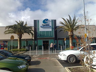
Noarlunga Centre is a suburb in the City of Onkaparinga in the southern suburbs of Adelaide, South Australia. The suburb is mostly commercial, being dominated by the Centro Colonnades shopping centre and the small 'Inspire Noarlunga' estate to the east of Goldsmith Road. The suburb is bordered by Beach Road to the north, Dyson Road to the west Goldsmith Road to the south and the Southern Expressway to the east. Burgess Drive, Seaman Road and David Witton Drive are the main thoroughfares inside the boundaries of the suburb.
Hackham is an outer metropolitan suburb of Adelaide, South Australia. It lies within the City of Onkaparinga.
Noarlunga Downs is a metropolitan suburb of Adelaide, South Australia. It lies within the City of Onkaparinga and has postcode 5168.
Blewitt Springs is a semi-rural suburb of Adelaide, South Australia. It is within the City of Onkaparinga.
Chandlers Hill is a suburb of Adelaide, South Australia. It lies within the City of Onkaparinga and has postcode 5159.
Coromandel East is a semi-rural suburb of Adelaide, South Australia. It lies within the City of Onkaparinga and has postcode 5157.
Hackham West is an outer southern suburb of Adelaide, South Australia. It is located in the City of Onkaparinga.

Kangarilla is a small rural town and locality around 33 km (21 mi) from Adelaide city centre, in South Australia. The area, formerly inhabited by Kaurna people, was settled by Europeans in 1840, not long after the British colonisation of South Australia. Today it lies within the City of Onkaparinga local government area, and has postcode 5157. At the 2016 census, Kangarilla had a population of 896.
Port Noarlunga South is a suburb in the Australian state of South Australia located in the Adelaide metropolitan area on the coastline of Gulf St Vincent about 30 kilometres south of the state capital of Adelaide.
Seaford Heights is a metropolitan suburb of Adelaide, South Australia. It lies within the City of Onkaparinga and has postcode 5169. Its boundaries are formed by Robinson Road on the north, Main South Road on the west, Victor Harbor Road & Ostrich Farm Road on the east, and The Southern Waste Depot on the south. It covers 77 hectares.
Whites Valley is a semi-rural suburb of Adelaide, South Australia. It is home to many vineyards.
