Port Willunga, South Australia

Last updated

Port Willunga
Adelaide,  South Australia
Port Willunga Beach.jpg
Port Willunga beach
Australia South Australia location map.svg
Red pog.svg
Port Willunga
Coordinates 35°15′37″S138°27′47″E / 35.260302°S 138.463188°E / -35.260302; 138.463188 [1]
Population1,785 (SAL 2021) [2]
Postcode(s) 5173
Time zone ACST (UTC+9:30)
 • Summer (DST) ACST (UTC+10:30)
LGA(s) City of Onkaparinga [1]
Region Southern Adelaide [3]
County Adelaide [4]
State electorate(s) Mawson [5]
Federal division(s) Mayo [6]
Suburbs around Port Willunga:
Gulf St Vincent Maslin Beach Maslin Beach
Gulf St Vincent Port Willunga Aldinga
Gulf St Vincent
Aldinga Beach
Aldinga Beach Aldinga
FootnotesAdjoining suburbs [1]

Port Willunga is a semi-rural suburb of Adelaide, South Australia. [1] It is known as Wirruwarrungga or Ruwarunga by the traditional owners, the Kaurna people, and is of significance as being the site of a freshwater spring said to be created by the tears of Tjilbruke, the creator being. [7]

Contents

The 2016 Australian census reported a population of 1,637 people. [8]

Port Willunga is located within the federal division of Mayo, the state electoral district of Mawson and the local government area of the City of Onkaparinga. [6] [5] [1]

Port Willunga Beach, South Australia Port Willunga Beach - Amanda Griffin.jpg
Port Willunga Beach, South Australia

Port Willunga beach is one of the most photographed beaches in South Australia and is a popular wedding location featuring the remains of the old Port Willunga Jetty with its golden cliff faces, crystal clear waters and soft white sands. [9] [10]

History

Before the British colonisation of South Australia, the Port Willunga area, along with most of the Adelaide plains area and down the western side of the Fleurieu Peninsula, was inhabited by the Kaurna people. There is a significant site associated with the Kaurna Dreaming of the creator ancestor Tjilbruke, with a commemorative plaque at the Esplanade car park. [11]

The name Port Willunga was first introduced in 1850. The first export cargo of wheat was loaded from this location in February 1850, with speculation that a wharf would be built there in the future. [12] Mr C.T. Hewitt claimed to have been the first to raise the proposition of such a construction. [13] Residents petitioned for a jetty to be constructed there in 1852 [14] and government tenders were invited for its construction in March 1853. [15] Difficulties raising money for the construction delayed its completion. [16] [17] The jetty was constructed in stages, and was functional in 1853 [18] with further works committed to the following year. [19] Tenders for the jetty extension were taken in August 1854. [20] Early exports from Port Willunga included slate, flour, bran and hay. [21]

Port Willunga was officially proclaimed a port of export in 1856 and again in 1861, then proclaimed a port of both import and export in 1865. [22]

In 1871 the jetty was placed under the care and management of the Aldinga District Council. [23] Jetty extensions of various cost and configuration were considered in December 1873. [24]

By the early 20th century, commercial shipping at Port Willunga had ceased, but the jetty remained in place and was used by fishermen, residents and holiday-makers visiting the area.

The timber jetty received heavy storm damage on multiple occasions, including in 1896, [25] 1906 [26] and 1910. [27] Fears for its future followed further storm damage in 1914. [28] An assessment in 1915 deemed the jetty damaged beyond repair, and discussions of constructing a new jetty, purely for recreational use began. [29] In 1928, locals were still petitioning government to build a replacement jetty. [30]

Shipping incidents

The Cowry was grounded on reef south of Port Willunga on 31 December 1887. [31]

The Star of Greece was wrecked off Port Willunga on 12 July 1888, [32] and forms the subject of a book published a century later by Geoffrey Manning. [33]

See also

Related Research Articles

The Kaurna people are a group of Aboriginal people whose traditional lands include the Adelaide Plains of South Australia. They were known as the Adelaide tribe by the early settlers. Kaurna culture and language were almost completely destroyed within a few decades of the British colonisation of South Australia in 1836. However, extensive documentation by early missionaries and other researchers has enabled a modern revival of both language and culture. The phrase Kaurna meyunna means "Kaurna people".

<span class="mw-page-title-main">Glenelg, South Australia</span> Suburb of Adelaide, South Australia

Glenelg is a beach-side suburb of the South Australian capital of Adelaide. Located on the shore of Holdfast Bay in Gulf St Vincent, it has become a tourist destination due to its beach and many attractions, home to several hotels and dozens of restaurants.

<span class="mw-page-title-main">Port Elliot, South Australia</span> Town in South Australia

Port Elliot is a town in South Australia toward the eastern end of the south coast of the Fleurieu Peninsula. It is situated on the sheltered Horseshoe Bay, a small bay off the much larger Encounter Bay. Pullen Island lies outside the mouth of the bay. At the 2006 census, Port Elliot had a population of 1,754, although this section of the coast is now built up almost all the way from Goolwa to Victor Harbor.

<span class="mw-page-title-main">City of Onkaparinga</span> Local government area in South Australia

The City of Onkaparinga is a local government area (LGA) located on the southern fringe of Adelaide, South Australia. It is named after the Onkaparinga River, whose name comes from Ngangkiparinga, a Kaurna word meaning women's river. It is the largest LGA in South Australia, with a population of over 170,000 people in both urban and rural communities and is also geographically expansive, encompassing an area of 518.3 km². The council is headquartered in the Noarlunga Centre with area offices situated in Aberfoyle Park, Woodcroft and Willunga.

<span class="mw-page-title-main">Aldinga, South Australia</span> Suburb of City of Onkaparinga, South Australia

Aldinga is a suburb of Adelaide in South Australia located about 45 kilometres south of the Adelaide city centre in the City of Onkaparinga. It is a small suburb, about a kilometre east of the edge of the larger suburb of Aldinga Beach, and about 3 km (1.9 mi) from the beachfront.

<span class="mw-page-title-main">Port Noarlunga, South Australia</span> Coastal suburb of Adelaide, South Australia

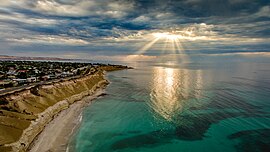
Port Noarlunga is a suburb in the City of Onkaparinga, South Australia. It is a small sea-side suburb, with a population of 2,918, about 30 kilometres to the south of the Adelaide city centre and was originally created as a sea port. This area is now popular as a holiday destination or for permanent residents wishing to commute to Adelaide or work locally. There is a jetty that connects to a 1.6 kilometres natural reef that is exposed at low tide.

<span class="mw-page-title-main">Tjilbruke</span> Creation being in Kaurna (an Aboriginal Australian group) mythology

Tjilbruke is an important creation ancestor for the Kaurna people of the Adelaide plains in the Australian state of South Australia. Tjilbruke was a Kaurna man, who appeared in Kaurna Dreaming dating back about 11,000 years. The Tjilbruke Dreaming Track or Tjilbruke Dreaming Trail is a major Dreaming trail, which connects sites from within metropolitan Adelaide southwards as far as Cape Jervis, some of which are Aboriginal sacred sites of great significance.

Willunga is a town located to the south of Adelaide, South Australia in the City of Onkaparinga, 47 km from the Adelaide city centre. This town is considered a suburb of the Adelaide metropolitan area, and it is located within the McLaren Vale wine-growing region. In the 2016 census, Willunga had a population of 2,308.

<span class="mw-page-title-main">District Council of Yankalilla</span> Local government area in South Australia

The District Council of Yankalilla is a local government area centred on the town of Yankalilla on the Fleurieu Peninsula in South Australia.

<span class="mw-page-title-main">Carrickalinga</span> Suburb of District Council of Yankalilla, South Australia

Carrickalinga is a small coastal town in South Australia about 60 kilometres (37 mi) south of Adelaide on the Fleurieu Peninsula overlooking Gulf St Vincent. The town has no shops, with the nearest being in Normanville, one kilometre away. Haycock Point separates two beaches, sometimes referred to as North Carrickalinga and South Carrickalinga beaches, both on Yankalilla Bay. Carrickalinga Creek discharges into the sea south of the town.

<span class="mw-page-title-main">Sellicks Beach, South Australia</span> Suburb of City of Onkaparinga, South Australia

Sellicks Beach, formerly spelt Sellick's Beach, is a suburb in the Australian state of South Australia located within Adelaide metropolitan area about 47 kilometres (29 mi) from the Adelaide city centre. It is an outer southern suburb of Adelaide and is located in the local government area of the City of Onkaparinga at the southern boundary of the metropolitan area. It is known as Witawali or Witawodli by the traditional owners, the Kaurna people, and is of significance as being the site of a freshwater spring said to be created by the tears of Tjilbruke, the creator being.

<span class="mw-page-title-main">Rapid Bay, South Australia</span> Coastal town in South Australia

Rapid Bay is a locality that includes a small seaside town and bay on the west coast of the Fleurieu Peninsula, South Australia. It lies within the District Council of Yankalilla and its township is approximately 100 km south of the state capital, Adelaide. A pair of jetties are popular attractions for recreational fishing, scuba diving and snorkelling. The bay particularly known as a site for observing leafy seadragons in the wild. Its postcode is 5204.

<span class="mw-page-title-main">Normanville, South Australia</span> Town in South Australia

Normanville is a coastal town in the Australian state of South Australia on the west coast of the Fleurieu Peninsula.

<span class="mw-page-title-main">Moana, South Australia</span> Suburb of Adelaide, South Australia

Moana is an outer coastal suburb in the south of Adelaide, South Australia. The suburb is approximately 36.4 km from the Adelaide city centre. It lies within the City of Onkaparinga local government area, and neighbours the suburbs Seaford, Maslin Beach, Seaford Rise and Port Noarlunga It is divided into two by Pedler Creek and the associated sand dune reserve. The beach is often referred to as Moana Beach.

<span class="mw-page-title-main">Yankalilla, South Australia</span> Town in South Australia

Yankalilla is an agriculturally based town situated on the Fleurieu Peninsula in South Australia, located 72 km south of the state's capital of Adelaide. The town is nestled in the Bungala River valley, overlooked by the southern Mount Lofty Ranges and acts as a service centre for the surrounding agricultural district.

<span class="mw-page-title-main">Aldinga Beach, South Australia</span> Suburb of City of Onkaparinga, South Australia

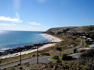
Aldinga Beach is an outer southern suburb of Adelaide, South Australia. It lies within the City of Onkaparinga and has the postcode 5173. At the 2016 census, Aldinga Beach had a population of 10,557. It lies about a kilometre west of the smaller suburb of Aldinga. The beach is a well-known spot for surfing, swimming, scuba diving, and snorkelling during the summer months. It overlooks an aquatic reserve which has been created to safeguard a unique reef formation.

<span class="mw-page-title-main">Ingalalla Waterfalls</span> Waterfall in South Australia

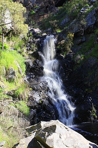
The Ingalalla Waterfalls, also known as Ingalalla Falls, is a cascade waterfall in the Australian state of South Australia, located in the locality of Hay Flat within the District Council of Yankalilla, on an unnamed creek on the Fleurieu Peninsula.

<span class="mw-page-title-main">Aldinga Scrub Conservation Park</span> Protected area in South Australia

Aldinga Scrub Conservation Park is a protected area in the Australian state of South Australia located in the suburb of Aldinga Beach about 46 kilometres south by west of the state capital of Adelaide.

The District Council of Willunga, was a local government area in South Australia seated at Willunga from 1853 until 1997.

<span class="mw-page-title-main">Hundred of Willunga</span> Cadastral in South Australia

The Hundred of Willunga is a cadastral unit of hundred covering the extreme south suburbs of the Adelaide metropolitan area. It is one of the eleven hundreds of the County of Adelaide. It was named in 1846 by Governor Frederick Robe probably deriving from a Kaurna/Ngarrindjeri place label willannga, meaning place of green trees.

References

  1. 1 2 3 4 5 "Search result for 'Port Willunga, SUB' with the following datasets selected - 'Suburbs and Localities', 'Counties', 'Local government Areas', 'SA Government Regions' and 'Gazetteer'". South Australian Government. Retrieved 12 April 2019.
  2. Australian Bureau of Statistics (28 June 2022). "Port Willunga (suburb and locality)". Australian Census 2021 QuickStats. Retrieved 28 June 2022.  OOjs UI icon edit-ltr-progressive.svg
  3. "Southern Adelaide SA Government region" (PDF). The Government of South Australia. Retrieved 17 April 2017.
  4. "Search result for "County of Adelaide, CNTY" with the following data sets selected - "Counties" and "Local Government Areas"". Property Location SA Map Viewer. Government of South Australia. Retrieved 24 April 2017.
  5. 1 2 "Mawson (Electoral district profile)". ELECTORAL COMMISSION SA. Retrieved 12 April 2019.
  6. 1 2 "Profile of the electoral division of Mayo (SA)". Australian Electoral Commission. 20 July 2018. Retrieved 12 April 2019.
  7. "Tjilbruke Dreaming Tracks". Kaurnaculture. 16 October 2013. Retrieved 16 November 2020.
  8. Australian Bureau of Statistics (27 June 2017). "Port Willunga (State Suburb)". 2016 Census QuickStats. Retrieved 12 April 2019. OOjs UI icon edit-ltr-progressive.svg
  9. "Southern Adelaide Wedding Venues". Adelaide Wedding Venues. Retrieved 20 January 2021.
  10. Commission, corporateName=South Australian Tourism (11 January 2021). "Visit South Australia - feel stimulated, relaxed, and inspired". southaustralia.com. Retrieved 20 January 2021.
  11. Malone, Gavin Damien Francis (2012). "Chapter 10: Kaurna Ancestor Being Tjilbruke: Commemorations". Phases of Aboriginal Inclusion in the Public Space in Adelaide, South Australia, since Colonisation (PhD). Chapter 10 PDF. Flinders University . Retrieved 17 November 2020.{{cite thesis}}: External link in |others= (help)
  12. "Local intelligence". South Australian Register . 8 February 1850. p. 2. Retrieved 15 May 2020.
  13. "Willunga District Council". Adelaide Observer (SA : 1843 - 1904). 13 May 1854. p. 5. Retrieved 15 May 2020.
  14. "Port Willunga". South Australian Register . 7 August 1852. p. 3. Retrieved 15 May 2020.
  15. "The Government Gazette". South Australian Register. 18 March 1853. p. 3. Retrieved 15 May 2020.
  16. "Willunga Jetty". South Australian Register (Adelaide, SA : 1839 - 1900). 20 August 1853. p. 3. Retrieved 15 May 2020.
  17. "Legislative Council". South Australian Register (Adelaide, SA : 1839 - 1900). 8 September 1853. p. 3. Retrieved 15 May 2020.
  18. "Hundred of Moorooroo. — District Councils Act". South Australian Register). 17 November 1853. p. 3. Retrieved 15 May 2020.
  19. "WILLUNGA DISTRICT COUNCIL". Adelaide Observer . 13 May 1854. p. 5. Retrieved 15 May 2020.
  20. "Advertising". Adelaide Times (SA : 1848 - 1858). 26 July 1854. p. 3. Retrieved 15 May 2020.
  21. "Conveyance of Produce from Tub Southern Districts". South Australian Register (Adelaide, SA : 1839 - 1900). 17 October 1854. p. 3. Retrieved 15 May 2020.
  22. "Port Willunga". South Australian Register . 2 December 1865. p. 3. Retrieved 15 May 2020.
  23. "PORT WILLUNGA JETTY". Evening Journal (Adelaide, SA : 1869 - 1912). 9 June 1871. p. 3. Retrieved 15 May 2020.
  24. "Extension of Willunga Jetty". South Australian Advertiser (Adelaide, SA : 1858 - 1889). 2 December 1873. p. 2. Retrieved 15 May 2020.
  25. "Port Willunga Jetty". Advertiser (Adelaide, SA : 1889 - 1931). 22 June 1896. p. 5. Retrieved 15 May 2020.
  26. "DEPUTATION". Observer (Adelaide, SA : 1905 - 1931). 18 August 1906. p. 4. Retrieved 15 May 2020.
  27. "Port Willunga Jetty Wrecked". Advertiser (Adelaide, SA : 1889 - 1931). 5 October 1910. p. 14. Retrieved 15 May 2020.
  28. "Port Willunga Jetty". Chronicle (Adelaide, SA : 1895 - 1954). 18 July 1914. p. 14. Retrieved 15 May 2020.
  29. "Port Willunga Jetty". Register (Adelaide, SA : 1901 - 1929). 16 June 1915. p. 10. Retrieved 15 May 2020.
  30. "Port Willunga Jetty". Chronicle (Adelaide, SA : 1895 - 1954). 14 April 1928. p. 15. Retrieved 15 May 2020.
  31. "Stranding of the Cowry at Port Willunga". South Australian Register (Adelaide, SA : 1839 - 1900). 2 January 1888. p. 5. Retrieved 15 May 2020.
  32. "A Tragic Wreck". Observer (Adelaide, SA : 1905 - 1931). 22 March 1919. p. 2. Retrieved 15 May 2020.
  33. "Book details shipwreck at Port Willunga". Times (Victor Harbor, SA : 1987 - 1999). 27 May 1988. p. 5. Retrieved 15 May 2020.

Further reading