Related Research Articles

Quantico Creek is a 13.7-mile-long (22.0 km) partially tidal tributary of the Potomac River in eastern Prince William County, Virginia. Quantico Creek rises southeast of Independent Hill, flows through Prince William Forest Park and Dumfries and empties into the Potomac at Possum Point.
Tearcoat Creek is an 18.3-mile-long (29.5 km) free-flowing tributary stream of the North River, itself a tributary of the Cacapon River, making it a part of the Potomac River and Chesapeake Bay watersheds. The creek is located in central Hampshire County, West Virginia. Its name is believed to have been derived from the tearing of the coats of British soldiers by low-hanging branches as they forded the stream during either the French and Indian or the American Revolutionary Wars.
Tilhance Creek is a 10.4-mile-long (16.7 km) tributary stream of Back Creek in Berkeley County of West Virginia's Eastern Panhandle.

The North River is a 55.3-mile-long (89.0 km) river in the mountains and Shenandoah Valley of northern Virginia, the United States. It joins the South River at Port Republic to form the South Fork Shenandoah River.

The Ragged Mountains are a small chain of rugged hills—an offshoot of the Blue Ridge Mountains—southwest of Charlottesville, Virginia. 980 acres (4.0 km2) have been preserved as the Ragged Mountain Natural Area.
Trout Run is an 18.5-mile-long (29.8 km) tributary of the Cacapon River, belonging to the Potomac River and Chesapeake Bay watersheds. The stream is located in Hardy County in West Virginia's Eastern Panhandle. Trout Run rises between Devils Hole Mountain and Great North Mountain near the Virginia state line in the George Washington National Forest. The stream empties into the Cacapon River at Wardensville.
Kettle Creek is a 7.3-mile-long (11.7 km) tributary stream of the South Fork South Branch Potomac River in Hardy and Pendleton counties in West Virginia's Eastern Panhandle. Kettle Creek rises on Mitchell Knob and flows north along the eastern flanks of Sweedlin Hill through Sweedlin Valley in the George Washington National Forest.

Town Hill is a mountain range located in Allegany County, Maryland and Bedford and Fulton Counties in Pennsylvania. Its southern end is 2.25 miles northwest of Kiefer in Allegany County. It trends northeasterly, and ends about 1.5 miles south of the town of Emmaville in Fulton County. Its highest elevation is 2000 feet.

Iona is an unincorporated community in Johnson Township, Knox County, Indiana.
Smith Creek is a 35.5-mile-long (57.1 km) tributary stream of the North Fork of the Shenandoah River in the Shenandoah Valley of Virginia. Its watershed comprises 106 square miles (270 km2) within Shenandoah and Rockingham counties on the western slope of the Massanutten Mountain ridge. Its headwaters lie in Rockingham County just north of Harrisonburg, and its confluence with the North Fork of the Shenandoah River is located just south of Mount Jackson.
The German River is the principal tributary of the North Fork of the Shenandoah River, flowing for 14.7 miles (23.7 km) in the U.S. state of Virginia. The river originates in northern Rockingham County, just east of the West Virginia border, in the George Washington National Forest, near the crest of Shenandoah Mountain in the Allegheny Mountains.
The Dry River is a 22.6-mile-long (36.4 km) tributary of the North River in the U.S. state of Virginia. It flows entirely within Rockingham County, rising within the George Washington National Forest east of the West Virginia border and flowing south to the North River at Bridgewater. Via the North River, it is part of the Shenandoah River system, flowing to the Potomac River.
The Middle River is a 70.6-mile-long (113.6 km) river in the U.S. state of Virginia. Flowing entirely within Augusta County, the Middle River joins the North River, which in turn meets the South River at Port Republic to form the South Fork Shenandoah River.
Battle Creek is an unincorporated community in Page County, in the U.S. state of Virginia. It is home to the county landfill, located on U.S. Route 340, which was cleared from the nominally forested area that is common in the locality.
Grove Hill is an unincorporated community in Page County, in the U.S. state of Virginia.
Oak Hill is an unincorporated community in Page County, in the U.S. state of Virginia.
Rose Hill, Rappahannock County is an unincorporated community in Rappahannock County, in the U.S. state of Virginia.
Round Hill, Rappahannock County is an unincorporated community in Rappahannock County, in the U.S. state of Virginia.
Oak Forest is an unincorporated community in Cumberland County, in the U.S. state of Virginia.

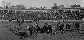
Lambeth Field or "The Colonnades" was a college football, baseball, and track stadium for the University of Virginia, named for W. A. Lambeth.
References
Coordinates: 38°39′23″N78°28′18″W / 38.65651°N 78.47167°W
