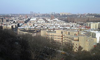
Inwood is a neighborhood in the New York City borough of Manhattan, at the northern tip of Manhattan Island, in the U.S. state of New York. It is bounded by the Hudson River to the west, Spuyten Duyvil Creek and Marble Hill to the north, the Harlem River to the east, and Washington Heights to the south.

Washington Heights is a neighborhood in the northern part of the borough of Manhattan in New York City. It is named for Fort Washington, a fortification constructed at the highest natural point on Manhattan by Continental Army troops to defend the area from the British forces during the American Revolutionary War. Washington Heights is bordered by Inwood to the north along Dyckman Street, by Harlem to the south along 155th Street, by the Harlem River and Coogan's Bluff to the east, and by the Hudson River to the west.

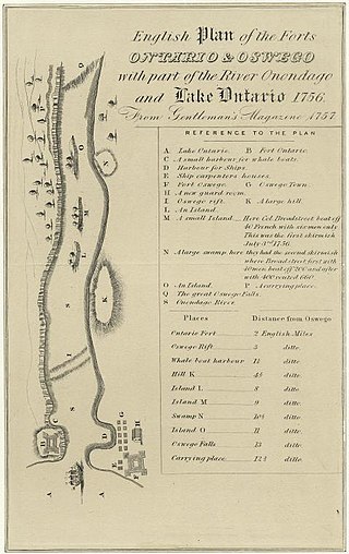
Fort Oswego was an 18th-century trading post in the Great Lakes region in North America, which became the site of a battle between French and British forces in 1756 during the French and Indian War. The fort was established in 1727, on the orders of New York governor William Burnet, adjacent to a 1722 blockhouse that had originally been a way station for French traders. The log palisade fort established a British presence on the Great Lakes.

The Battle of Long Island, also known as the Battle of Brooklyn and the Battle of Brooklyn Heights, was an action of the American Revolutionary War fought on August 27, 1776, at and near the western edge of Long Island in present-day Brooklyn. The British defeated the Continental Army and gained access to the strategically important Port of New York, which they held for the rest of the war. It was the first major battle to take place after the United States declared its independence on July 4, 1776, in Philadelphia. It was the largest battle of the Revolutionary War in terms of both troop deployment and combat.

In the United States, trolley parks, which started in the 19th century, were picnic and recreation areas along or at the ends of streetcar lines in most of the larger cities. These were precursors to amusement parks. Trolley parks were often created by the streetcar companies to give people a reason to use their services on weekends.

Midland Beach is a neighborhood of Staten Island in New York City. It lies along the east-central coast of the island, in the area known locally as the "Mid-Island, Staten Island" or the "East Shore".

The Battle of Fort Oswego was one in a series of early French victories in the North American theatre of the Seven Years' War won in spite of New France's military vulnerability. During the week of August 10, 1756, a force of regulars and Canadian militia under General Montcalm captured and occupied the British fortifications at Fort Oswego, located at the site of present-day Oswego, New York.

South Beach is a neighborhood on the East Shore of Staten Island, New York City, situated directly south of the Verrazzano-Narrows Bridge. South Beach is bounded by New York Bay on the southeast, Seaview Avenue on the southwest, Laconia Avenue on the northwest, Reid and McClean Avenues on the north, and Lily Pond Avenue on the northeast. It is adjacent to Midland Beach to the southwest, Dongan Hills and Old Town/Concord to the northwest, and Fort Wadsworth and Rosebank to the northeast.
Grymes Hill is a 374 feet (114 m) tall hill formed of serpentine rock on Staten Island, New York. It is the second highest natural point on the island and in the five boroughs of New York City. The neighborhood of the same name encompasses an area of 0.894 square miles (2.32 km2) and has a population of 8,263 people. The hill also includes parts of the Silver Lake neighborhood. The area includes part of ZIP Codes 10301 and 10304.

Hudson Heights is a residential neighborhood within Washington Heights in Upper Manhattan, New York City. Most residences are apartment buildings, many of which are cooperatives, and most were constructed in the 1920s through 1940s. The Art Deco style is prominent, along with Tudor Revival. Notable complexes include Hudson View Gardens and Castle Village, which were both developed by Dr. Charles V. Paterno, and were designed by George F. Pelham and his son, George F. Pelham, Jr., respectively.

The Battle of Fort Washington was fought in New York on November 16, 1776, during the American Revolutionary War between the United States and Great Britain. It was a British victory that gained the surrender of the remnant of the garrison of Fort Washington near the north end of Manhattan. It was one of the worst Patriot defeats of the war.

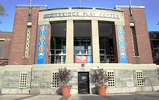
Highbridge Park is a public park on the western bank of the Harlem River in Washington Heights, Manhattan, New York City. It stretches between 155th Street and Dyckman Street in Upper Manhattan. The park is operated by the New York City Department of Parks and Recreation. The City maintains the southern half of the park, while the northern half is maintained by the non-profit New York Restoration Project. Prominent in the park are the Manhattan end of the High Bridge, the High Bridge Water Tower, and the Highbridge Play Center.

Cabrini Boulevard spans the Manhattan neighborhood of Hudson Heights, running from West 177th Street in the south, near the George Washington Bridge, to Fort Tryon Park in the north, along an escarpment of Manhattan schist overlooking the Henry Hudson Parkway and the Hudson River. It is the westernmost city street in the neighborhood except for a one block loop formed by Chittenden Avenue between West 186th and 187th Streets.

Fort Washington was a fortified position near the north end of Manhattan Island, at the island's highest point, within the modern-day neighborhood of Washington Heights in New York City. The Fort Washington Site is listed on the National Register of Historic Places.

Audubon Avenue is an avenue in the Washington Heights neighborhood in Upper Manhattan that runs north-south, west of and parallel to Amsterdam Avenue. Its southern terminus is at West 165th Street and St. Nicholas Avenue, and its northern terminus is at Fort George Avenue, just north of West 193rd Street. It crosses over the Trans-Manhattan Expressway, east of the eastern portal of the expressway's tunnel.

The South Beach–Franklin Delano Roosevelt Boardwalk, alternately referred to as the FDR Boardwalk or the South Beach Boardwalk, is a boardwalk facing the Lower New York Bay on the East Shore of Staten Island, one of the five boroughs of New York City. The boardwalk is the main feature of a public park that stretches from Fort Wadsworth and the Verrazzano-Narrows Bridge to Miller Field, both part of the Gateway National Recreation Area. The park also contains numerous recreational facilities, including a skate park.
Montcalm Park Historic District is a national historic district located at Oswego in Oswego County, New York. The district includes 28 contributing buildings, one contributing site, and three contributing structures. The centerpiece of the district is Montcalm Park, a two-acre landscaped park dedicated in 1913. The park was once the site of a military fort called Fort George, built by the British in 1755 and destroyed by the French commander Louis-Joseph de Montcalm in 1756. The site is now Montcalm Park, bordered by West Schulyer Street, Montcalm Street and West 6th Street.

Fort George Amusement Park was a trolley park and amusement park that operated in the Washington Heights and Inwood neighborhoods of Upper Manhattan, New York City, in the late 19th and early 20th centuries. It occupied an area between 190th and 192nd Streets east of Amsterdam Avenue, within present-day Highbridge Park.
The following is an alphabetical list of articles related to New York City. New York City is a city in the United States state of New York.


