
Fort Sumter is a sea fort built on an artificial island near Charleston, South Carolina to defend the region from a naval invasion. It was built after British forces captured and occupied Washington during the War of 1812 via a naval attack. The fort was still incomplete in 1861 when the Battle of Fort Sumter occurred, sparking the American Civil War. It was severely damaged during the battle and left in ruins. Although there were some efforts at reconstruction after the war, the fort as conceived was never completed. Since the middle of the 20th century, Fort Sumter has been open to the public as part of the Fort Sumter and Fort Moultrie National Historical Park, operated by the National Park Service.

Morris Island is an 840-acre (3.4 km2) uninhabited island in Charleston Harbor in South Carolina, accessible only by boat. The island lies in the outer reaches of the harbor and was thus a strategic location in the American Civil War. The island is part of the cities of Charleston and Folly Beach, in Charleston County.

The Battle of Fort Sumter was the bombardment of Fort Sumter near Charleston, South Carolina by the South Carolina militia. It ended with its surrender by the United States Army, beginning the American Civil War.

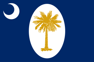
The flag of South Carolina is a symbol of the U.S. state of South Carolina consisting of a blue field with a white palmetto tree and white crescent. Roots of this design have existed in some form since 1775, being based on one of the first American Revolutionary War flags. While keeping most of its design intact since its adoption, it has varied over the years.

Fort Pickens is a pentagonal historic United States military fort on Santa Rosa Island in the Pensacola, Florida, area. It is named after American Revolutionary War hero Andrew Pickens. It is the largest of four forts built to defend Pensacola Bay and its navy yard. The fort was completed in 1834 and was one of the few forts in the South that remained in Union hands throughout the American Civil War. It remained in use until 1947. Fort Pickens is included within the Gulf Islands National Seashore, and as such, is administered by the National Park Service.

Fort Moultrie is a series of fortifications on Sullivan's Island, South Carolina, built to protect the city of Charleston, South Carolina. The first fort, formerly named Fort Sullivan, built of palmetto logs, inspired the flag and nickname of South Carolina, as "The Palmetto State". The fort was renamed for the U.S. patriot commander in the Battle of Sullivan's Island, General William Moultrie. During British occupation, in 1780–1782, the fort was known as Fort Arbuthnot.
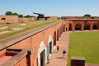
Fort Pulaski National Monument is located on Cockspur Island between Savannah and Tybee Island, Georgia. It preserves Fort Pulaski, the place where the Union Army successfully tested rifled cannon in combat during the American Civil War in 1862, the success of which rendered brick fortifications obsolete. The fort was also used as a prisoner-of-war camp.

The First Battle of Fort Wagner was fought on July 10 and 11, 1863, on Morris Island in Charleston harbor during the American Civil War. An attempt by the Union Army to capture Fort Wagner was repulsed. The more famous Second Battle of Fort Wagner, which involved an assault by the 54th Massachusetts, would be fought on July 18.
Castle Pinckney is a small masonry fortification constructed by the United States government, in the harbor of Charleston, South Carolina in 1810. It was used very briefly as a prisoner-of-war camp and artillery position during the American Civil War. It was named to the National Register of Historic Places in 1970.

The siege of Fort Pulaski concluded with the Battle of Fort Pulaski fought April 10–11, 1862, during the American Civil War. Union forces on Tybee Island and naval operations conducted a 112-day siege, then captured the Confederate-held Fort Pulaski after a 30-hour bombardment. The siege and battle are important for innovative use of rifled guns which made existing coastal defenses obsolete. The Union initiated large-scale amphibious operations under fire.
South Carolina was the first state to secede from the Union in December 1860, and was one of the founding member states of the Confederacy in February 1861. The bombardment of the beleaguered U.S. garrison at Fort Sumter in Charleston Harbor on April 12, 1861, is generally recognized as the first military engagement of the war. The retaking of Charleston in February 1865, and raising the flag again at Fort Sumter, was used for the Union symbol of victory.

Charleston, South Carolina, was a hotbed of secession at the start of the American Civil War and an important Atlantic Ocean port city for the fledgling Confederate States of America. The first shots against the Federal government were those fired there by cadets of the Citadel to stop a ship from resupplying the Federally held Fort Sumter. Three months later, the bombardment of Fort Sumter triggered a massive call for Federal troops to put down the rebellion. Although the city and its surrounding fortifications were repeatedly targeted by the Union Army and Navy, Charleston did not fall to Federal forces until the last months of the war. Charleston was devastated.

The Second Battle of Charleston Harbor, also known as the Siege of Charleston Harbor, the Siege of Fort Wagner, or the Battle of Morris Island, took place during the American Civil War in the late summer of 1863 between a combined U.S. Army/Navy force and the Confederate defenses of Charleston, South Carolina.

Siege artillery is heavy artillery primarily used in military attacks on fortified positions. At the time of the American Civil War, the U.S. Army classified its artillery into three types, depending on the gun's weight and intended use. Field artillery were light pieces that often traveled with the armies. Siege and garrison artillery were heavy pieces that could be used either in attacking or defending fortified places. Seacoast artillery were the heaviest pieces and were intended to be used in permanent fortifications along the seaboard. They were primarily designed to fire on attacking warships. The distinctions are somewhat arbitrary, as field, siege and garrison, and seacoast artillery were all used in various attacks and defenses of fortifications. This article will focus on the use of heavy artillery in the attack of fortified places during the American Civil War.

The Floating Battery of Charleston Harbor was an ironclad vessel that was constructed by the Confederacy in early 1861, a few months before the American Civil War ignited. Apart from being a marvel to contemporary Charlestonians, it was a strategic naval artillery platform that took part in the bombardment of Fort Sumter on April 12 and April 13, 1861, making it the first floating battery to engage in hostilities during the Civil War.

The 1st New York Engineer Regiment was an engineer regiment that served in the Union Army during the American Civil War. It was also known as Serrell's Engineers, New York Volunteer Corps of Engineers, or Engineer's and Artizans. The regiment served initially in the Lower Seaboard Theater, and later in the Richmond–Petersburg Campaign.
Fort Pemberton was one of the larger confederate forts was constructed in the defense of Charleston, South Carolina during the American Civil War. At the war's outset in 1861, it became evident that control of the western regions of James Island and the Stono River was to be an important element in the defense of the city. Confederate military authorities of the time believed that Union occupation of James Island would leave Charleston subject to attack from the southeast. From this position the city would assuredly fall to the Union. Although there were many gun batteries in place along the south and east side of James Island, Fort Pemberton was the only fortress in defense of this region.

Battery White was an artillery battery constructed by the Confederates during the American Civil War. Built in 1862–63 to defend Winyah Bay on the South Carolina coast, the battery was strongly situated and constructed; however, it was inadequately manned, and was captured without resistance during the final months of the war.

Battery Cheves is a historic artillery battery located at James Island, Charleston, South Carolina. It was built in 1863, and designed to protect the area between Fort Johnson and Battery Haskell. At the end of the war this battery mounted two pieces of heavy artillery. The earthen redoubt measures approximately 280 feet long and 240 feet deep. It has a 12-foot, 6 inch, high parapet wall and a powder magazine about 15 feet in height.
Granby was the first European settlement in the area of present-day Columbia in the U.S. state of South Carolina. Settlement began around 1718 with the establishment of a trading post by the British on the Congaree River. Many small farms were settled by German, Swiss, and Scots-Irish immigrants. Granby was the largest town and county seat of Lexington County until the early 19th century, when the town began to gradually decline as Columbia, the state capital, grew. The once thriving colonial town was mostly unoccupied after the first quarter of the 19th century. Today, the area is part of present-day Cayce.


