
George R. Crook was a career United States Army officer who served in the American Civil War and the Indian Wars. He is best known for commanding U.S. forces in the 1886 campaign that led to the defeat of the Apache leader Geronimo. As a result, the Apache nicknamed Crook Nantan Lupan, which means "Grey Wolf."

Fort Laramie was a significant 19th-century trading post, diplomatic site, and military installation located at the confluence of the Laramie and the North Platte Rivers. They joined in the upper Platte River Valley in the eastern part of the present-day U.S. state of Wyoming. The fort was founded as a private trading-post in the 1830s to service the overland fur trade; in 1849, it was purchased by the United States Army. The site was located east of the long climb leading to the best and lowest crossing-point over the Rocky Mountains at South Pass and became a popular stopping-point for migrants on the Oregon Trail. Along with Bent's Fort on the Arkansas River, the trading post and its supporting industries and businesses were the most significant economic hub of commerce in the region.

Standing Bear was a Ponca chief and Native American civil rights leader who successfully argued in U.S. District Court in 1879 in Omaha that Native Americans are "persons within the meaning of the law" and have the right of habeas corpus, thus becoming the first Native American judicially granted civil rights under American law. His first wife Zazette Primeau (Primo), daughter of Lone Chief, mother of Prairie Flower and Bear Shield, was also a signatory on the 1879 writ that initiated the famous court case.
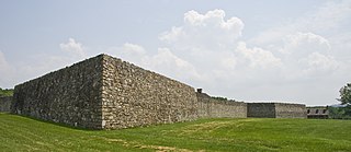
Fort Frederick State Park is a public recreation and historic preservation area on the Potomac River surrounding the restored Fort Frederick, a fortification active in the French and Indian War (1754–1763) and the American Revolutionary War (1775-1783). The state park lies south of the town of Big Pool, Maryland. The Chesapeake and Ohio Canal runs through the park grounds. The site was designated a National Historic Landmark in 1973.

Fort Robinson is a former U.S. Army fort and now a major feature of Fort Robinson State Park, a 22,000-acre (8,900 ha) public recreation and historic preservation area located 2 miles (3.2 km) west of Crawford on U.S. Route 20 in the Pine Ridge region of northwest Nebraska.

Thomas Henry Tibbles was an abolitionist, author, journalist, Indians’ rights activist, and politician who was born in Ohio and lived in various other places in the United States, especially Nebraska. Tibbles played an important role in the trial of Standing Bear, a legal battle which led to the liberation of the Ponca tribe from the Indian territory in Oklahoma in the year 1879. This landmark case led to important improvements in the civil rights of Native Americans throughout the country and opened the door to further advancement.

North Omaha is a community area in Omaha, Nebraska, in the United States. It is bordered by Cuming and Dodge Streets on the south, Interstate 680 on the north, North 72nd Street on the west and the Missouri River and Carter Lake, Iowa on the east, as defined by the University of Nebraska at Omaha and the Omaha Chamber of Commerce.

Fort Fetterman was constructed in 1867 by the United States Army on the Great Plains frontier in Dakota Territory, approximately 11 miles northwest of present-day Douglas, Wyoming. Located high on the bluffs south of the North Platte River, it served as a major base for the start of several United States military expeditions against warring Native American tribes. The fort is listed on the National Register of Historic Places.
North Omaha, Nebraska has a recorded history spanning over 200 years, pre-dating the rest of Omaha, encompassing wildcat banks, ethnic enclaves, race riots and social change. North Omaha has roots back to 1812 and the founding of Fort Lisa. It includes the Mormon settlement of Cutler's Park and Winter Quarters in 1846, a lynching before the turn of the twentieth century, the thriving 24th Street community of the 1920s, the bustling development of its African-American community through the 1950s, a series of riots in the 1960s, and redevelopment in the late 20th and early 21st century.
Significant events in the history of North Omaha, Nebraska include the Pawnee, Otoe and Sioux nations; the African American community; Irish, Czech, and other European immigrants, and; several other populations. Several important settlements and towns were built in the area, as well as important social events that shaped the future of Omaha and the history of the nation. The timeline of North Omaha history extends to present, including recent controversy over schools.

Fort Omaha, originally known as Sherman Barracks and then Omaha Barracks, is an Indian War-era United States Army supply installation. Located at 5730 North 30th Street, with the entrance at North 30th and Fort Streets in modern-day North Omaha, Nebraska, the facility is primarily occupied by the Metropolitan Community College. A Navy Operational Support Center and Marine Corps Reserve unit, along with an Army Reserve unit occupy the periphery of the 82.5 acres (33.4 ha) fort. The government deeded all but four parcels of the land to the Metropolitan Community College in 1974.
The history of Omaha, Nebraska, began before the settlement of the city, with speculators from neighboring Council Bluffs, Iowa staking land across the Missouri River illegally as early as the 1840s. When it was legal to claim land in Indian Country, William D. Brown was operating the Lone Tree Ferry to bring settlers from Council Bluffs to Omaha. A treaty with the Omaha Tribe allowed the creation of the Nebraska Territory, and Omaha City was founded on July 4, 1854. With early settlement came claim jumpers and squatters, and the formation of a vigilante law group called the Omaha Claim Club, which was one of many claim clubs across the Midwest. During this period many of the city's founding fathers received lots in Scriptown, which was made possible by the actions of the Omaha Claim Club. The club's violent actions were challenged successfully in a case ultimately decided by the U.S. Supreme Court, Baker v. Morton, which led to the end of the organization.

The Harry Buford House is a historic house located at 1804 North 30th Street in North Omaha, Nebraska. Built in 1929 in a Period Revival style, it was designated a landmark by the City of Omaha in 1983.
The Omaha and Council Bluffs Railway and Bridge Company, known as O&CB, was incorporated in 1886 in order to connect Omaha, Nebraska with Council Bluffs, Iowa over the Missouri River. With a sanctioned monopoly over streetcar service in the two cities, the O&CB was among the earliest major electric street railway systems in the nation, and was one of the last streetcar operators in the U.S., making its last run in 1955.
The Ponca Reservation of the Ponca Tribe of Nebraska is located in northeast Nebraska, with the seat of tribal government located in Niobrara, Knox County. The Indian reservation is also the location of the historic Ponca Fort called Nanza. The Ponca tribe does not actually have a reservation because the state of Nebraska will not allow them to have one. However, they do in fact have a 15-county service delivery area, including counties spread throughout Nebraska, South Dakota and Iowa.
North 30th Street is a two-way street that runs south–north in the North Omaha area of Omaha, Nebraska. With the street beginning at Dodge Street, historically significant sections include those from Dodge to Lake Street, from Fort Street to Laurel Avenue, and from Weber to Bondesson Streets.

Fort Harney was a United States Army outpost in eastern Oregon in the United States. It was named in honor of Brigadier General William S. Harney. Fort Harney was used as a supply depot and administrative headquarters from 1867 to 1880 during the Army's campaign against Northern Paiute bands in Eastern Oregon and the Bannock uprising in the same area. Today, nothing remains of Fort Harney except a small cemetery.

Hospitals in Omaha, Nebraska have been integral to the city's growth since its founding in 1857. The city has a number of hospitals that were founded by religious groups, and has many medical centers resultant from the mergers of various hospitals. Nebraska is also home to a VA facility that was the only hospital in the United States with a nuclear reactor.

Fort Apache Historic Park is a tribal historic park of the White Mountain Apache, located at the former site of Fort Apache on the Fort Apache Indian Reservation. The park interprets the rich and troubled history of relations between the Apache and other Native American tribes at the fort, which was converted into a Bureau of Indian Affairs boarding school after its military use ended. The park, which covers 288 acres (117 ha) of the former fort and school, as well as a nearby military cemetery, form the National Historic Landmark Fort Apache and Theodore Roosevelt School historic district.


