Jobbers Canyon Historic District

Last updated
Jobbers Canyon Historic District
Warehouse district street scene. Omaha - NARA - 283718.tif
A view of the canyon
LocationFarnam Street on the north, South Eighth Street on the east, Jackson Street on the south, and South Tenth Street on the west, Downtown Omaha, Nebraska
Built1920
ArchitectJohn Latenser; Et al.
Architectural styleRenaissance, Romanesque, Richardsonian Romanesque
NRHP reference No. 86003408
Significant dates
Added to NRHP1979 [1]
Removed from NRHPMarch 26, 2002 [2]

Jobbers Canyon Historic District was a large industrial and warehouse area comprising 24 buildings located in downtown Omaha, Nebraska, US. It was roughly bound by Farnam Street on the north, South Eighth Street on the east, Jackson Street on the south, and South Tenth Street on the west. [3] In 1989, all 24 buildings in Jobbers Canyon were demolished, representing the largest National Register historic district loss to date. [4] [5]

Contents

About

The development of Jobber's Canyon mirrored Omaha's emergence as a central hub in the United States transportation system of the late 19th century and early 20th century. As the "Gateway to the West" serving several historic trails the Canyon housed several warehouses, grocers, and other dry goods outfitters for merchants throughout the Old West, particularly those along the Great Platte River Road. Railroad entrepreneurs, land speculators, and merchants built Jobbers Canyon from the 1870s onward. After George Francis Train landed the Union Pacific and Credit Foncier of America in Omaha, the city quickly turned into a transportation hub. [6] Fruit and vegetable wholesalers, meatpackers, and all sorts of supply people created a range of businesses, building almost 24 densely congested buildings in a seven-block by three-block area in downtown Omaha. At its peak, Jobbers Canyon had more than 1,700,000 square feet (160,000 m2) of office, warehouse, industrial and shipping space. [7]

Speaking in 1987 about Jobber's Canyon, J. Jackson Walter, president of the National Trust for Historic Preservation said, "The warehouse district, to the best of my knowledge, is certainly one of the Middle West's or the nation's finest collection of this sort of buildings." [8]

Individual properties

All of Omaha's largest and most notable wholesale and mercantile businesses built massive warehouse structures in the area by the early 20th century. Six- and seven-story red brick buildings filled with jobbing houses towered over red brick streets, creating a canyon-like feeling and leading to the area becoming called "Jobber's Canyon". The brick-surfaced South Ninth Street was an important streetscape in the city, with brick and cobblestone streets, railroad spur lines, loading docks, and dock canopies all contributing to the character of Jobbers Canyon. [9]

The area included the Kingman Implement Company building, also called the U.S. Tire building, located at 923 Farnam Street. It was built in 1900 as a six-story brick Renaissance Revival style structure. Kingman was a wholesale distributor of farm implements and vehicles. The Fairbanks, Morse and Company building at 923 Farnam Street was six stories tall. It was designed in 1907 by Omaha architects Fisher and Lawrie. In 1907 Fairbanks, Morse and Company was the largest manufacturer of gasoline, kerosene, and crude oil engines in the United States.[ citation needed ]

In 1906, architect Charles Cleves designed a six-story building for the U.S. Supply Company, which distributed of wholesale steam, water and plumbing supplies. The Dempster Building was a five-story Renaissance Revival-style warehouse designed by Omaha architect John Latenser, Sr. in 1902. The Dempster Mill Manufacturing Company started as a small retail pump and windmill shop in 1880 and eventually grew to become a major manufacturer of windmills and farm implements. Architects Fisher & Lawrie designed another six-story red brick warehouse structure in 1900 for the Lee-Glass-Andreesen Hardware Company, which originated in 1880 as Lee, Fried & Co. They were wholesalers of hardware, cutlery and tinware.[ citation needed ]

The eight-story Creighton Block was built for John A. Creighton to house the Byrne and Hammer Dry Goods Company. The most ornate building in Jobbers Canyon, this Renaissance Revival-style structure was designed by architect Charles Cleves. [9] Today the Greenhouse Apartments at 900 Farnam Street are the only building left from the original Jobbers Canyon.

The Nash Block at 902 Farnam Street was designed by Thomas R. Kimball and built in 1907.

Jobber's Canyon buildingsAddressBuiltDemolishedNotes [10]
U.S. Supply Co.901 Farnam Street19061989
Kingman Implement Co.923 Farnam Street19001989
Harding Cream Co.802-810 Harney Street19041989
H.J. Lee warehouse822 Harney Street19001989
Fairbanks, Morse and Co.902 Harney Street19071989
Dempster908 Harney Street19021989
Crane Co. then Nogg Brothers Paper Co.323 South Tenth Street19051989Bought by Nogg in 1966
Carpenter Paper Co.815 Harney Street19061989Top floor remodeled in 1928
John Deere Plow Co.402 South Ninth Street19081989Largest structure in the district
Creighton Block824 Howard Street19051989
Rector and Wilhelmy Co.523 South Tenth Street18891989
Richardson902 Jackson Street18911989
D. H. Food Co.823 Howard Street19011989
J.I. Case Plow Works814 Jackson Street19131989
Trimble Brothers802 Jackson Street19201989
American Radiator Co.417 South Tenth Street19051989
John Day Co.401 South Tenth Streetc. 18921989Remodeled 1932
Brunswick-Balke-Collender407 South Tenth Streetc. 18881989
Nash Block 902 Farnam Street1907Only remaining building; divided into residential apartments
Omaha Cold Storage Co.809 Farnam Street19131989
Lee-Coit-Andreesen Hardware Co.815 Farnam Street19161989

Demolition

The M.E. Smith Building, designed by Frederick S. Stott, built in 1920 and formerly located at 201 South 10th Street. It was demolished in 1989. M. E. Smith Building.jpg
The M.E. Smith Building, designed by Frederick S. Stott, built in 1920 and formerly located at 201 South 10th Street. It was demolished in 1989.

Agriculture-related industries have always been important to Omaha's workforce. In addition to the meat industry, major employers have included the Kellogg Company and the Campbell Soup Company, which produces frozen Swanson and LeMenu products in Omaha. Exercising its influence, industry giant ConAgra transformed the skyline by demolishing Jobber's Canyon in 1989. Its world headquarters sat on 30 acres (120,000 m2) of the former historic district for the next 26 years. [11] At the time Charles M. Harper, chief executive of ConAgra, was asked about the district, and responded saying it was "some big, ugly red brick buildings". [8] ConAgra's campus created almost 300,000 square feet (30,000 m2) of office space. [7]

Critics charged that the city was being "held hostage" by ConAgra, [12] and that the city should not have to choose between its corporations and its historical legacies. [8]

At the time Omaha's then-planning director, Marty Shukert, said it was more important to keep the city's downtown core healthy than to keep the historic district. "This development may not be a large thing to a city with multiple corporate headquarters and a large development industry," he said. "In a relatively small community like this, the effects of a growing, national corporation echo throughout the economy." [8]

Trial

People for Responsible Omaha Urban Development (PROUD), with the National Trust for Historic Preservation as an intervening plaintiff, sued the Interstate Commerce Commission, the National Park Service and the Army Corps of Engineers in order to stop the demolition. The lawsuit alleged that the federal agencies failed to comply with the National Environmental Policy Act and the National Historic Preservation Act. The trial began in May 1988, and the district court immediately denied plaintiffs' request to stop demolition. The district court later ruled in favor of defendants on the merits, with a court of appeals affirming the district court decision in a brief opinion.

The court of appeal granted a partial stay of demolition during the appeals at a time when five buildings remained standing in the district. The injunction was later dissolved, and ultimately, all 24 buildings in the National Register-listed historic district were demolished, and the adjacent corporate campus was completed in 1992. [13]

Legacy

Two historic districts listed on the National Register currently border the former Jobbers Canyon site. They include the Old Market Historic District, which was listed in 1979; and the Omaha Rail and Commerce Historic District, which was listed in 1996. The Union Station, Burlington Train Station and Bemis Bag Company Building are all nearby buildings that have been included on the Register individually, reflecting the area's significance.

The National Park Service officially delisted the non-existent Jobbers Canyon Historic District in 2002. [2] In 2005 a restaurant called "Jobber's Canyon" opened in the Old Market, but later closed. [14] Some critics charge that Omaha's dual losses of Jobbers Canyon and the Union Stockyards represent a blatant disregard for the city's working-class history. [15]

In 2015, ConAgra moved its headquarters to Chicago and cut 1,500 of the 2,700 jobs at the Omaha offices. [16]

See also

Related Research Articles

<span class="mw-page-title-main">Conagra Brands</span> Multi National Food Conglomerate

Conagra Brands, Inc. is an American consumer packaged goods holding company headquartered in Chicago, Illinois. Conagra makes and sells products under various brand names that are available in supermarkets, restaurants, and food service establishments. Based on its 2021 revenue, the company ranked 331st on the 2022 Fortune 500.

<span class="mw-page-title-main">Old Market (Omaha, Nebraska)</span> United States historic place

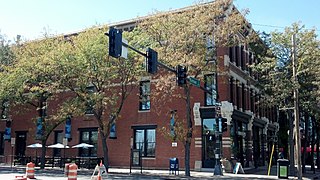
The Old Market is a neighborhood located in downtown Omaha, Nebraska, United States, and is bordered by South 10th Street to the east, 13th Street to the west, Farnam Street to the north and Jackson Street to the South. The neighborhood has many restaurants, art galleries and upscale shopping. The area retains its brick paved streets from the turn of the 20th century, horse-drawn carriages, and covered sidewalks in some areas. It is not uncommon to see a variety of street performers, artists, and other vendors.

<span class="mw-page-title-main">History of Omaha, Nebraska</span> Nebraska city settled on west bank of Missouri River

The history of Omaha, Nebraska, began before the settlement of the city, with speculators from neighboring Council Bluffs, Iowa staking land across the Missouri River illegally as early as the 1840s. When it was legal to claim land in Indian Country, William D. Brown was operating the Lone Tree Ferry to bring settlers from Council Bluffs to Omaha. A treaty with the Omaha Tribe allowed the creation of the Nebraska Territory, and Omaha City was founded on July 4, 1854. With early settlement came claim jumpers and squatters, and the formation of a vigilante law group called the Omaha Claim Club, which was one of many claim clubs across the Midwest. During this period many of the city's founding fathers received lots in Scriptown, which was made possible by the actions of the Omaha Claim Club. The club's violent actions were challenged successfully in a case ultimately decided by the U.S. Supreme Court, Baker v. Morton, which led to the end of the organization.

Charles Michael Harper was an American businessman who led ConAgra Foods from 1975 to 1993, growing the company by many acquisitions. He was born in Michigan, attended Purdue University as an undergraduate, and earned his MBA at the University of Chicago. During his tenure at ConAgra, sales rose from $636 million in 1974 to $9 billion in 1987. Some of the largest sales increases came in frozen-food and poultry.

<span class="mw-page-title-main">South Omaha Main Street Historic District</span> Historic district in Nebraska, United States

The South Omaha Main Street Historic District is located along South 24th Street between M and O Streets in South Omaha, Nebraska. It was added to the National Register of Historic Places in 1989. Home to dozens of historically important buildings, including the Packer's National Bank Building, the historic district includes 129 acres (0.52 km2) and more than 32 buildings.

<span class="mw-page-title-main">Omaha Rail and Commerce Historic District</span> Historic district in Nebraska, United States

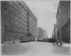
The Omaha Rail and Commerce Historic District, roughly bounded by Jackson, 15th, and 8th Streets, as well as the Union Pacific main line, is located in downtown Omaha, Nebraska. Today this historic district includes several buildings listed individually on the National Register of Historic Places, including the Union Pacific Depot and the Burlington Station.

<span class="mw-page-title-main">Economy of Omaha, Nebraska</span>

The economy of Omaha, Nebraska is linked to the city's status as a major commercial hub in the Midwestern United States since its founding in 1854. Dubbed the "Motor Mouth City" by The New York Times, Omaha is widely regarded as the telecommunications capital of the United States. The city's economy includes agriculture, food processing, insurance, transportation, healthcare and education. Warren Buffett of Berkshire Hathaway has lived in Omaha all of his life, as have the ConAgra Foods, Union Pacific Railroad and Mutual of Omaha Companies, and Kiewit Corporation, all Fortune 500 corporations.

<span class="mw-page-title-main">Downtown Omaha</span> Central business district in Omaha

Downtown Omaha is the central business, government and social core of the Omaha-Council Bluffs metropolitan area, U.S. state of Nebraska. The boundaries are Omaha's 20th Street on the west to the Missouri River on the east and the centerline of Leavenworth Street on the south to the centerline of Chicago Street on the north, also including the CHI Health Center Omaha. Downtown sits on the Missouri River, with commanding views from the tallest skyscrapers.

<span class="mw-page-title-main">Lincoln Highway (Omaha)</span>

The Lincoln Highway in Omaha, Nebraska, runs east–west from near North 183rd Street and West Dodge Road in Omaha, Nebraska, towards North 192nd Street outside of Elkhorn. This section of the Lincoln Highway, one of only 20 miles (32 km) that were paved with brick in Nebraska, is one of the most well-preserved in the country. The roadway was listed on the National Register of Historic Places in 1984. The Lincoln Highway was the first road across the United States, traversing coast-to-coast from Times Square in New York City to Lincoln Park in San Francisco, California.

<span class="mw-page-title-main">Nash Block</span> United States historic place

The Nash Block, also known as the McKesson-Robbins Warehouse and currently as The Greenhouse, is located at 902-912 Farnam Street in Omaha, Nebraska. Designed by Thomas R. Kimball and built in 1907, the building is the last remnant of Downtown Omaha's Jobbers Canyon. It was named an Omaha Landmark in 1978, and was listed on the National Register of Historic Places in 1985.

<span class="mw-page-title-main">Douglas County Courthouse (Nebraska)</span> United States historic place

The present Douglas County Courthouse is located at 1701 Farnam Street in Omaha, Nebraska, United States. Built in 1912, it was added to the National Register of Historic Places in 1979. Notable events at the courthouse include two lynchings and the city's first sit-in during the Civil Rights Movement. Five years after it was opened, the building was almost destroyed by mob violence in the Omaha Race Riot of 1919.

<span class="mw-page-title-main">Beebe and Runyan Furniture Showroom and Warehouse</span> United States historic place

The Beebe and Runyan Furniture Showroom and Warehouse is located at 105 South 9th Street in Downtown Omaha, Nebraska. The building was listed on the National Register of Historic Places on July 23, 1998, and is a contributing property to the Warehouses in Omaha Multiple Property Submission.

<span class="mw-page-title-main">National Register of Historic Places listings in Douglas County, Nebraska</span>

This is a list of the National Register of Historic Places listings in Douglas County, Nebraska.

<span class="mw-page-title-main">Poppleton Block</span> United States historic place

The Poppleton Block is located at 1001 Farnam Street in Downtown Omaha, Nebraska. The building was built in 1880 for Omaha lawyer and politician A.J. Poppleton, and was designated an Omaha Landmark on July 13, 1982, and was listed on the National Register of Historic Places later that year.

John Latenser Sr. (1858–1936) was an American architect whose influential public works in Omaha, Nebraska, numbered in the dozens. His original name was Johann Laternser.

<span class="mw-page-title-main">Burlington Headquarters Building</span> United States historic place

The Burlington Headquarters Building, also called Burlington Place, is located at 1004 Farnam Street in Downtown Omaha, Nebraska. This four-story brick building was originally designed by Alfred R. Dufrene and built in 1879 next to Jobbers Canyon. It was redesigned by noted Omaha architect Thomas R. Kimball in 1899, and vacated by the railroad in 1966. The building was listed on the National Register of Historic Places in 1974, designated an Omaha Landmark in 1978, and rehabilitated in 1983. Today it is office space.

<span class="mw-page-title-main">West Farnam Apartments</span> United States historic place

The West Farnam Apartments are located at 3817 Dewey Avenue in Midtown Omaha, Nebraska. The building was reportedly the first luxury apartment building constructed in Omaha.

The Ford Warehouse, also known as the Simon Brothers Building, is located at 1024 Dodge Street in Downtown Omaha, Nebraska. It is a six-story brick and stone building constructed in 1919 and was added to the National Register of Historic Places in 1999. It is located near the Omaha Rail and Commerce Historic District and the site of the former Jobbers Canyon Historic District, and is three blocks from the Old Market Historic District. Additionally, the building is also in accordance with the patterns for significance detailed in the Warehouses in Omaha Multiple Property Submission.

References

  1. "National Register Information System". National Register of Historic Places . National Park Service. March 13, 2009.
  2. 1 2 (2002) National Park Service National Historic Register Listings April 2, 2002. National Park Service. Retrieved 7/8/07.
  3. (nd) National Register of Historic Places - Nebraska, Douglas County. Retrieved 7/8/07.
  4. Gratz, R.B. (1996) Living City: How America's Cities Are Being Revitalized by Thinking Small in a Big Way. John Wiley and Sons. p. V.
  5. National Trust for Historic Preservation and Zagars, J. (1997) Preservation Yellow Pages: The Complete Information Source for Homeowners, Communities, and Professionals. John Wiley and Sons. p.80.
  6. Larsen, L. and Cottrell, B. (1997) The Gate City: A History of Omaha. University of Nebraska Press. p. 26.
  7. 1 2 Gratz, R.B. (1996) Living City: How America's Cities Are Being Revitalized by Thinking Small in a Big Way. John Wiley and Sons. p. 6.
  8. 1 2 3 4 (1987) "Historic district at issue in Omaha," New York Times. 12/13/87. Retrieved 7/8/07.
  9. 1 2 (nd) "Jobbers Canyon". Archived 2006-11-13 at the Wayback Machine Mountain Lumber Company. Retrieved 7/8/07.
  10. Spegel, Daniel D. (Summer 2012). "'Big, Ugly Red Brick Buildings': The Fight to Save Jobbers Canyon" (PDF). Nebraska History. pp. 54–83.
  11. Reeves, R. (nd) Omaha, Douglas County Archived 2011-07-20 at the Wayback Machine . University of Nebraska-Lincoln. Retrieved 7/8/07.
  12. Schwab, J. (1989) "Omaha held hostage," Progressive. 53(5). p 36-39.
  13. "People for Responsible Omaha Urban Development v. Interstate Commerce Commission". Defense Environmental Network and Information Exchange. Retrieved 7/8/07.
  14. Keenan, J. (2005) Omaha World-Herald. 11/11/05. Retrieved 7/8/07.
  15. Biga, L. A. (1998) "How the Mighty Did Fall: The Stockyards Nears the End of an Era." New Horizons. 9/21/98. Eastern Nebraska Office of Aging. Retrieved 6/22/07.
  16. "ConAgra headquarters to leave Omaha for Chicago". Nebraska Public Media. Retrieved 2022-09-29.

Bibliography

Coordinates: 41°15′21″N95°55′38″W / 41.25583°N 95.92722°W / 41.25583; -95.92722