Fort Peck, Montana

Last updated

Fort Peck, Montana
Valley County Montana Incorporated and Unincorporated areas Fort Peck Highlighted.svg
Location of Fort Peck, Montana
Coordinates: 48°00′25″N106°27′19″W / 48.00694°N 106.45528°W / 48.00694; -106.45528
Country United States
State Montana
County Valley
Area
[1]
  Total0.89 sq mi (2.31 km2)
  Land0.89 sq mi (2.31 km2)
  Water0.00 sq mi (0.00 km2)
Elevation
[2]
2,202 ft (671 m)
Population
 (2020)
  Total239
  Density267.64/sq mi (103.30/km2)
Time zone UTC-7 (Mountain (MST))
  Summer (DST) UTC-6 (MDT)
ZIP code
59255
Area code 406
FIPS code 30-28450
GNIS feature ID2412642 [2]

Fort Peck is a town in Valley County, Montana, United States. The population was 239 at the 2020 census. [3]

Contents

History

The name Fort Peck is associated with Col. Campbell K. Peck, the partner of Elias H. Durfee in the Leavenworth, Kansas trading firm of Durfee and Peck. In 1867, company employee Abe Farwell constructed the Fort Peck trading post along the Missouri River, which enjoyed a virtual monopoly in trade with the Sioux and Assiniboine people. After its short life as a trading post, Fort Peck served as an Indian agency from 1873 until 1878. At that time, the agency was moved to its current location at Poplar. Fort Peck had a post office from 1879 to 1881.

A new town of Fort Peck, located approximately two miles north of the original, was built in 1934 to house Army Corps of Engineers employees involved in the construction of the Fort Peck Dam. Designed to be temporary, the government-owned town nevertheless included many features of a permanent town, including an administrative headquarters, a hospital, stores, a theater, a recreation hall, and other facilities. Totally inadequate to house the 10,000-plus employees, Fort Peck was soon joined by numerous shanty towns, including Wheeler, New Deal, Delano Heights, and Park Grove. The Fort Peck Original Houses Historic District, the Fort Peck Theatre, and the hospital, administration building, and other associated public works properties are listed in the National Register. [4]

The Administration Building, [5] the Employee's Hotel and Garage, [6] the Garage and Fire Station, [7] the Hospital, [8] and the Recreation Hall [9] of the government-run town are listed on the National Register of Historic Places.

Culture

The U.S. Army Corps of Engineers, which oversees the powerhouses, dam, lake, and dredge cuts, [10] is the major employer in Fort Peck, as well as, other government programs. Until recently all of the houses in Fort Peck were government built.

Fort Peck draws people from hundreds of miles away to recreate around Fort Peck Reservoir. Most popular is utilizing the lake and dredge cuts for boating, swimming, and fishing. [11] [12] Camping and barbecuing are very popular and facilities for camping and cooking are well developed.

Besides the lake, Fort Peck offers several more activities. The Fort Peck Theatre performs plays during the summer [13] and draws large crowds. The Fort Peck Interpretive Center shows the history of the area, from the dinosaurs to the dam. [14]

Geography

According to the United States Census Bureau, the town has a total area of 0.86 square miles (2.23 km2), all land. [15]

Climate

Climate data for Fort Peck, Montana (Fort Peck Power Plant) (1991–2020 normals, extremes 1956–present)
MonthJanFebMarAprMayJunJulAugSepOctNovDecYear
Record high °F (°C)59
(15)
69
(21)
79
(26)
91
(33)
100
(38)
107
(42)
108
(42)
110
(43)
103
(39)
91
(33)
78
(26)
66
(19)
110
(43)
Mean daily maximum °F (°C)28.3
(−2.1)
33.2
(0.7)
46.2
(7.9)
60.0
(15.6)
70.7
(21.5)
79.6
(26.4)
88.6
(31.4)
88.3
(31.3)
76.6
(24.8)
60.9
(16.1)
44.1
(6.7)
32.3
(0.2)
59.1
(15.1)
Daily mean °F (°C)17.9
(−7.8)
22.4
(−5.3)
34.3
(1.3)
46.9
(8.3)
57.2
(14.0)
66.3
(19.1)
73.5
(23.1)
72.6
(22.6)
62.1
(16.7)
48.8
(9.3)
33.9
(1.1)
22.4
(−5.3)
46.5
(8.1)
Mean daily minimum °F (°C)7.5
(−13.6)
11.6
(−11.3)
22.4
(−5.3)
33.7
(0.9)
43.8
(6.6)
53.0
(11.7)
58.5
(14.7)
56.8
(13.8)
47.6
(8.7)
36.6
(2.6)
23.7
(−4.6)
12.5
(−10.8)
34.0
(1.1)
Record low °F (°C)−42
(−41)
−40
(−40)
−28
(−33)
−1
(−18)
9
(−13)
28
(−2)
39
(4)
33
(1)
15
(−9)
−4
(−20)
−24
(−31)
−38
(−39)
−42
(−41)
Average precipitation inches (mm)0.30
(7.6)
0.30
(7.6)
0.38
(9.7)
0.92
(23)
2.52
(64)
2.67
(68)
2.39
(61)
1.40
(36)
1.05
(27)
0.94
(24)
0.36
(9.1)
0.35
(8.9)
13.58
(345)
Average precipitation days (≥ 0.01 in)4.84.14.45.89.510.67.75.65.95.64.04.572.5
Source: NOAA [16] [17]

Demographics

Historical population
CensusPop.Note
1990 325
2000 240−26.2%
2010 233−2.9%
2020 2392.6%
U.S. Decennial Census [18] [3]

2010 census

As of the census [19] of 2010, there were 233 people, 99 households, and 73 families living in the town. The population density was 270.9 inhabitants per square mile (104.6/km2). There were 110 housing units at an average density of 127.9 per square mile (49.4/km2). The racial makeup of the town was 93.6% White, 3.0% Native American, 0.4% Asian, and 3.0% from two or more races.

There were 99 households, of which 22.2% had children under the age of 18 living with them, 68.7% were married couples living together, 2.0% had a female householder with no husband present, 3.0% had a male householder with no wife present, and 26.3% were non-families. 21.2% of all households were made up of individuals, and 9.1% had someone living alone who was 65 years of age or older. The average household size was 2.35 and the average family size was 2.74.

The median age in the town was 48.9 years. 18% of residents were under the age of 18; 4.4% were between the ages of 18 and 24; 19.4% were from 25 to 44; 39.9% were from 45 to 64; and 18.5% were 65 years of age or older. The gender makeup of the town was 52.8% male and 47.2% female.

2000 census

As of the census [20] of 2000, there were 240 people, 91 households, and 75 families living in the town. The population density was 274.9 inhabitants per square mile (106.1/km2). There were 99 housing units at an average density of 113.4 per square mile (43.8/km2). The racial makeup of the town was 96.25% White, 2.08% Native American, and 1.67% from two or more races.

There were 91 households, out of which 38.5% had children under the age of 18 living with them, 73.6% were married couples living together, 5.5% had a female householder with no husband present, and 16.5% were non-families. 14.3% of all households were made up of individuals, and 7.7% had someone living alone who was 65 years of age or older. The average household size was 2.64 and the average family size was 2.89.

In the town, the population was spread out, with 28.8% under the age of 18, 2.9% from 18 to 24, 21.7% from 25 to 44, 32.9% from 45 to 64, and 13.8% who were 65 years of age or older. The median age was 43 years. For every 100 females, there were 92.0 males. For every 100 females age 18 and over, there were 87.9 males.

The median income for a household in the town was $47,083, and the median income for a family was $50,938. Males had a median income of $32,500 versus $33,750 for females. The per capita income for the town was $17,943. None of the families and 0.8% of the population were living below the poverty line, including no under eighteens and 6.9% of those over 64.

Notable people

See also

Related Research Articles

<span class="mw-page-title-main">Valley County, Montana</span> County in Montana, United States

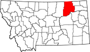
Valley County is a county in the U.S. state of Montana. Valley County was created in 1893 with area partitioned from Dawson County. As of the 2020 census, the population was 7,578. Its county seat is Glasgow. It is located on the Canada–United States border with Saskatchewan.

<span class="mw-page-title-main">Camp Verde, Arizona</span> Town in Yavapai County, Arizona

Camp Verde is a town in Yavapai County, Arizona, United States. As of the 2010 census, the population of the town is 10,873.

<span class="mw-page-title-main">West Baden Springs, Indiana</span> Town in Indiana, United States

West Baden Springs is a town in French Lick Township, Orange County, in the U.S. state of Indiana. The population was 574 at the 2010 census.

<span class="mw-page-title-main">Smithland, Kentucky</span> City in Kentucky, United States

Smithland is a home rule-class city in Livingston County, Kentucky, United States, at the confluence of the Ohio and Cumberland Rivers. The population was 301 at the 2010 census, a drop from 401 in 2000. It is the county seat of Livingston County.

<span class="mw-page-title-main">Belt, Montana</span> Town in Montana, United States

Belt is a town in Cascade County, Montana, United States. The population was 510 according to the 2020 census. It is part of the Great Falls, Montana metropolitan area.

<span class="mw-page-title-main">Branford Center, Connecticut</span> United States historic place

Branford Center is a neighborhood and census-designated place (CDP) in the town of Branford, Connecticut, United States. The CDP encompasses the traditional town center area and the area known as Branford Point. The population of the CDP was 5,819 at the 2010 census.

<span class="mw-page-title-main">East Otto, New York</span> Town in New York, United States

East Otto is a town in Cattaraugus County, New York, United States. The population was 977 at the 2020 census. The town, along with neighboring Otto, is named after an agent of the Holland Land Company, Jacob Otto. The town of East Otto is on the northern border of the county.

<span class="mw-page-title-main">Otto, New York</span> Town in New York, United States

Otto is a town in Cattaraugus County, New York, United States. The population was 775 at the 2020 census. The name comes from Jacob S. Otto, an agent of the Holland Land Company. The town lies on the northern border of Cattaraugus County.

<span class="mw-page-title-main">Hope Mills, North Carolina</span> Town in North Carolina, United States

Hope Mills is a town in Cumberland County, North Carolina, United States. Its population was 15,176 at the 2010 census.

<span class="mw-page-title-main">Badin, North Carolina</span> Town in North Carolina, United States

Badin is a town located in Stanly County, North Carolina, United States. At the 2010 census, the town had a total population of 1,974.

<span class="mw-page-title-main">St. Henry, Ohio</span> Village in Ohio, United States

St. Henry or Saint Henry is a village in Mercer County, Ohio, United States. The population was 2,596 at the 2020 census.

<span class="mw-page-title-main">Fort Supply, Oklahoma</span> Town in Oklahoma, United States

Fort Supply is a town in Woodward County, Oklahoma, United States, 13 kilometres (8.1 mi) northwest of the city of Woodward, the county seat. The population was 330 at the 2010 census.

<span class="mw-page-title-main">Beaver, Pennsylvania</span> Borough in Pennsylvania, United States

Beaver is a borough in, and the county seat of, Beaver County, Pennsylvania, United States. It is located near the confluence of the Beaver and Ohio Rivers, approximately 30 miles (48 km) northwest of Pittsburgh. As of the 2020 census, the population was 4,438.

<span class="mw-page-title-main">Miles Township, Pennsylvania</span> Township in Pennsylvania, United States

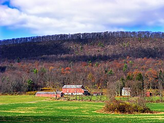
Miles Township is a township in Centre County, Pennsylvania, United States. It is part of the State College, Pennsylvania Metropolitan Statistical Area. The population was 2,013 at the 2020 census, an increase over the figure of 1,983 tabulated in 2010. Miles Township and nearby Milesburg were named after Samuel Miles, who co-owned the Centre Furnace, along with Colonel John Patton.

<span class="mw-page-title-main">Mobridge, South Dakota</span> City in South Dakota, United States

Mobridge also Kȟowákataŋ Otȟúŋwahe is a city in Walworth County, South Dakota, United States. The population was 3,261 according to the 2020 census.

<span class="mw-page-title-main">Huttonsville, West Virginia</span> Town in West Virginia, United States

Huttonsville is a town in Randolph County, West Virginia, United States, along the Tygart Valley River. The population was 163 at the 2020 census.

<span class="mw-page-title-main">Sinclair, Wyoming</span> Town in Wyoming, United States

Sinclair is a town in Carbon County, Wyoming, United States.

<span class="mw-page-title-main">Crows Nest, Indiana</span> Town in Indiana, United States

Crows Nest is a town in Washington Township, Marion County, Indiana, United States, approximately 7 miles (11 km) north of downtown Indianapolis. The population was 67 at the 2020 census. It has existed as an "included town" since 1970, when it was incorporated into Indianapolis as part of Unigov. It is part of Indianapolis, but retains a functioning town government under IC 36-3-1-11.

<span class="mw-page-title-main">Marathon (village), New York</span> Village in New York, United States

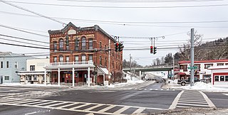
Marathon is a village within the town of Marathon in Cortland County, New York, United States. The population of the village was 919 at the 2010 census, out of 1,967 in the entire town.

<span class="mw-page-title-main">Litchfield (borough), Connecticut</span> Borough in Connecticut, United States

Litchfield is a borough in, and the village center of, the town of Litchfield in Litchfield County, Connecticut, United States. The population was 1,258 at the 2010 census. The entire borough was designated a Connecticut historic district in 1959 by special act of the state General Assembly and is listed on the National Register of Historic Places. Part of the borough is also a National Historic Landmark, the Litchfield Historic District.

References

  1. "ArcGIS REST Services Directory". United States Census Bureau. Retrieved September 5, 2022.
  2. 1 2 U.S. Geological Survey Geographic Names Information System: Fort Peck, Montana
  3. 1 2 "U.S. Census website". United States Census Bureau . Retrieved November 2, 2021.
  4. Montana Placenames: From Alzada to Zortman, p. 92. Montana Placenames Companion Website
  5. Rebecca J. Otto (August 1985). "National Register of Historic Places Inventory/Nomination: Administration Building". National Park Service . Retrieved July 26, 2017. With photo from 1985.
  6. Rebecca J. Otto (August 1985). "National Register of Historic Places Inventory/Nomination: Employee's Hotel and Garage / Fort Peck Hotel". National Park Service . Retrieved July 26, 2017. With four photos from 1985.
  7. Rebecca J. Otto (August 1985). "National Register of Historic Places Inventory/Nomination: Garage and Fire Station / Security Center (Fire & Police) & Vehicle Storage". National Park Service . Retrieved July 26, 2017. With two photos from 1985.
  8. Rebecca J. Otto (August 1985). "National Register of Historic Places Inventory/Nomination: Hospital / Apartments". National Park Service . Retrieved July 26, 2017. With three photos from 1985.
  9. Rebecca J. Otto (August 1985). "National Register of Historic Places Inventory/Nomination: Recreation Hall". National Park Service . Retrieved July 26, 2017. With two photos from 1985.
  10. "Fort Peck Dam". US Army Corps of Engineers. Retrieved August 22, 2023.
  11. "Dredge Cut". www.visitmt.com. Retrieved June 17, 2023.
  12. "FISHMT :: Waterbody Details". myfwp.mt.gov. Retrieved June 17, 2023.
  13. "Fort Peck Summer Theatre". Fort Peck Theatre. Retrieved August 22, 2023.
  14. "Fort Peck Interpretive Center". US Fish and Wildlife Service. Retrieved August 22, 2023.
  15. "US Gazetteer files 2010". United States Census Bureau. Archived from the original on July 2, 2012. Retrieved December 18, 2012.
  16. "NOWData - NOAA Online Weather Data". National Oceanic and Atmospheric Administration. Retrieved December 15, 2023.
  17. "Summary of Monthly Normals 1991-2020". National Oceanic and Atmospheric Administration. Retrieved December 15, 2023.
  18. "Census of Population and Housing". Census.gov. Retrieved June 4, 2015.
  19. "U.S. Census website". United States Census Bureau . Retrieved December 18, 2012.
  20. "U.S. Census website". United States Census Bureau . Retrieved January 31, 2008.