Montana is a state in the Mountain West division of the Western United States. It is bordered by Idaho to the west, North Dakota and South Dakota to the east, Wyoming to the south, and the Canadian provinces of Alberta, British Columbia, and Saskatchewan to the north. It is the fourth-largest state by area, the eighth-least populous state, and the third-least densely populated state. Its state capital is Helena, while the largest city is Billings. The western half of Montana contains numerous mountain ranges, while the eastern half is characterized by western prairie terrain and badlands, with smaller mountain ranges found throughout the state. The state has a reputation for a libertarian bent in popular opinion and policy.

Franklin County is a county located in the U.S. state of Vermont. As of the 2020 census, the population was 49,946. Its county seat is the city of St. Albans. It borders the Canadian province of Quebec. The county was created in 1792 and organized in 1796. Franklin County is part of the Burlington metropolitan area.

Fayette County is a county located in the U.S. state of Illinois. As of the 2020 census, the population was 21,488. Its county seat is Vandalia, the site of the Vandalia State House State Historic Site. Ramsey Lake State Recreation Area is located in the northwest part of this county.

Idaho County is a county in the U.S. state of Idaho, and the largest by area in the state. As of the 2020 census, the population was 16,541. The county seat is Grangeville. Previous county seats of the area were Florence (1864–68), Washington (1868–75), and Mount Idaho (1875–1902).

Franklin County is a county located in the U.S. state of Idaho. As of the 2020 Census the county had a population of 14,194. The county seat and largest city is Preston. The county was established in 1913 and named after Franklin D. Richards, an Apostle of the Church of Jesus Christ of Latter-day Saints. It is the only Franklin County in the United States that is not named after Benjamin Franklin. Franklin County is part of the Logan, UT-ID Metropolitan Statistical Area.

Clark County is a rural county in the U.S. state of Idaho; its county seat and largest city is Dubois. As of the 2020 Census, the county had a population of 790, making it the least populous county in the state.

Caribou County is a county located in the U.S. state of Idaho. As of the 2020 Census the county had a population of 7,027. The county seat and largest city is Soda Springs.
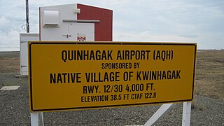
Quinhagak is a city in Bethel Census Area, Alaska, United States. As of the 2010 census, the population of the city is 669, up from 555 in 2000.

Angoon is a city on Admiralty Island in Hoonah-Angoon Census Area, Alaska, United States. At the 2000 census the population was 572; by the 2010 census the population had declined to 459. The name in Tlingit, Aangóon, means roughly "isthmus town."
Vandalia is a city in and the county seat of Fayette County, Illinois, United States. At the 2020 Census, the population was 7,458. Vandalia is 69 miles (111 km) northeast of St. Louis, on the Kaskaskia River. It served as the state capital of Illinois from 1819 until 1839, when the seat of state government moved to the current capital of Springfield. Vandalia was for years the western terminus of the National Road. From 1836 onward, Vandalia is the home of the Vandalia State House State Historic Site.

Amo is a town in Clay Township, Hendricks County, Indiana, United States. The population was 408 at the 2020 census.

Hollis is a town in Hillsborough County, New Hampshire, United States. The population was 8,342 at the 2020 census, growing 9% from the 2010 population of 7,684. The town center village is listed on the National Register of Historic Places as Hollis Village Historic District.

Dobbs Ferry is a village in Westchester County, New York, United States. The population was 10,875 according to the 2010 United States Census. In 2021, its population rose to an estimated 11,456. The village of Dobbs Ferry is located in, and is a part of, the town of Greenburgh. The village ZIP code is 10522. Most of the village falls within the boundaries of the Dobbs Ferry Union Free School District.

Vandalia is a city in Montgomery County, Ohio, United States, and a suburb of Dayton. Its population was 15,209 during the 2020 census. In addition to being the city closest to Dayton International Airport, Vandalia lies at the crossroads of I-75 and I-70.
The United States Government Publishing Office is an agency of the legislative branch of the United States Federal government. The office produces and distributes information products and services for all three branches of the Federal Government, including U.S. passports for the Department of State as well as the official publications of the Supreme Court, the Congress, the Executive Office of the President, executive departments, and independent agencies.

Aguila is an unincorporated community and census-designated place (CDP) in Maricopa County, Arizona, United States. It is located on U.S. Route 60, 25 miles (40 km) west of Wickenburg and 22 miles (35 km) northeast of Wenden. Major economic activities include cantaloupe farming and formerly included mining. It uses the same street numbering system as Phoenix. As of the 2020 census, the population of Aguila was 565, down from 798 in 2010.

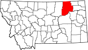
Hinsdale is an unincorporated community and census-designated place in Valley County, Montana, United States. The town's population was 217 and the community's population as a whole was 583 as of the 2010 census. The community is located on the Milk River and U.S. Route 2, with Montana Highway 537 headed north out of town and South Bench Road crossing the railroad tracks and running south of town. Hinsdale has a post office with ZIP code 59241.

Beaverton is an unincorporated community in Valley County, Montana, United States located near Beaver Creek on the Valley County/Phillips County line. The community itself is all but a ghost town, with First Creek Seeds being the only remaining feature. Beaverton is halfway between the town of Saco and the community of Hinsdale.
Thoeny is a ghost town in the northern part of Valley County, Montana, United States, near the Canadian province of Saskatchewan. Thoeny is located north of Hinsdale and west of Opheim. The school house still stands. There is also a cemetery located on the hill.