Fort Stonewall

Last updated

Fort Stonewall
Near Gainestown, Alabama in United States
Civil War Brooke Cannon in front of City Hall, Jackson, Alabama LCCN2010640240.tif
Brooke rifle S-96 used at Fort Sidney Johnston, similar to the Brooke rifles used at Fort Stonewall. This piece is displayed in front of the Jackson, Alabama, City Hall.
USA Alabama location map.svg
Red pog.svg
Fort Stonewall
Usa edcp location map.svg
Red pog.svg
Fort Stonewall
Coordinates 31°21′32″N87°46′05″W / 31.35889°N 87.76806°W / 31.35889; -87.76806 [1]
TypeEarthwork and battery
Site information
OwnerPrivate
Controlled byPrivate
Open to
the public
No
Site history
Built1862
Built by Confederate States of America, Alabama
In use1862-1865
Demolished1865
Battles/warsAmerican Civil War

Fort Stonewall was a fort built by the state of Alabama in 1862 in present-day Clarke County, Alabama, during the American Civil War. Fort Stonewall was constructed on the Alabama River by enslaved Africans to protect the interior of Alabama in the event that Mobile was captured by Union forces. [2] Additional forts were concurrently constructed to defend against Union advances up the Tombigbee River and to protect nearby salt works. The fort never saw any military action and was destroyed at the close of the American Civil War. Earthworks and a cannon are all that exist at the site today, which is located on private property.

Contents

Background

After the capture of New Orleans in 1862, Mobile became the last major port in the eastern Gulf of Mexico. Mobile subsequently became the center of blockade running on the Gulf of Mexico, receiving imports from the Caribbean and becoming an important lifeline to the Confederate economy. The Confederate government began strengthening land defenses to protect the city from land attack and strengthened Fort Morgan and Fort Gaines. [3]

After the fall of New Orleans, some citizens of Mobile fled to the interior of Alabama due to fear the United States would soon assault Mobile. Refugees from Mississippi also settled near Choctaw Bluff on the Alabama River in Clarke County. [4] In response to these fears, the state of Alabama and the Confederate government began constructing forts to protect the interior of Alabama from federal invasion. [5] A fort would be built at Choctaw Bluff to prevent any advancement up the Alabama River, which provided access to the Selma Naval Ordnance Works and Montgomery. [6] Other forts were constructed along the Tombigbee River at Oven Bluff and the site of Fort Carney. [5] These forts would not only prevent advancement up the Tombigbee into Alabama and Mississippi, but would provide defense for the saltworks in Clarke County. The salt springs in Clarke County have been used since the early Mississippian period and became important to the Confederacy due to the salt shortage caused by the Union blockade. In response, the state of Alabama constructed saltworks that included a hospital, cemetery, worker housing, and stores. [7]

History

Construction

In the fall of 1862, Governor John Gill Shorter ordered the construction of forts at Choctaw, Oven and Carney bluffs. [8] The Choctaw Bluff fort was constructed 91 feet (28 m) above the Alabama River. The location was chosen in a bend so as to expose a boat to artillery fire while approaching, passing, and leaving sight of the fort. [2] Captain Ebenezer Farrand of the Confederate States Navy initially oversaw construction of the forts, then, in the spring of 1863, the engineer office at Mobile was given command of the forts. [8] Lieutenant Colonel Victor von Scheliha, a native of Prussia who served as the chief engineer of the Department of the Gulf, and was responsible for a string of defenses around Mobile, was assigned as chief engineer over the forts by Brigadier General Danville Leadbetter on January 31, 1863. [9] After von Scheliha, Colonel James W. Robertson was given command of construction. On June 17, 1863, Major General Dabney H. Maury ordered the fort at Choctaw Bluff to be named Fort Stonewall in honor of Stonewall Jackson and the fort at Oven Bluff to be named Fort Sidney Johnston in honor of Albert Sidney Johnston. [8]

Von Scheliha considered Fort Stonewall to be a model of river defense. [2] In 1868, he described the fort's design as:

Two gulleys, running at nearly right angles to the river, facilitated the mounting of two guns five feet above high-water mark. All other guns were placed in gun-chambers sunk into the natural ground, and lying in different vertical and horizontal planes, thus forming terraces en échelon . The position was to be protected in the rear by a strong line in bastions. From the parade of the work well-covered communications led into the several gun-chambers, which all stood in communication with each other by a gallery 4 feet wide and 6 feet high. From these galleries a short branch led to the service-magazines established for every gun; the main magazine was built in one of the many gulleys within the enceinte of the place. A heavy parapet, giving perfect protection to riflemen aiming at the portholes of the enemy's vessels, extended from gun-chamber to gun-chamber, serving at the same time as a traverse against any enfilading fire. Provisions were stored in bomb-proof storehouses; there were bomb-proof surgeon-rooms, kitchens, and wells; heavy traverses against enfilading fire or fire en reverse had been erected wherever deemed necessary. [10]

Fort Sidney Johnston was located eight miles (13 km) due west of Fort Stonewall. [2] A military road with a centrally-located military camp connected the forts. In addition to the forts themselves, obstructions were placed in the Tombigbee River near Fort Sidney Johnston. Obstructions were unable to be placed in the Alabama River near Fort Stonewall, and as a result, Fort Stonewall was constructed larger than Fort Sidney Johnston. [5]

By the fall of 1863, construction on both forts was completed. The total cost of construction of Fort Stonewall was approximately 10,000 Confederate States dollars. [6]

2018 LiDAR hillshade map showing Fort Stonewall's enceinte on the left and the Alabama River on the right Fort Stonewall LiDAR map.jpg
2018 LiDAR hillshade map showing Fort Stonewall's enceinte on the left and the Alabama River on the right

Slave labor

Forts Stonewall and Sidney Johnston were built by enslaved African-Americans who were impressed into service by the state of Alabama. Slaves were impressed from the central Alabama counties of Marengo, Greene, Tuscaloosa, Perry, Sumter, Dallas, Clarke, Choctaw, and Lowndes and worked under Confederate government supervision. [5] The slave owners in these counties were required to furnish slaves, rations for twenty days, shovels, and axes. The state supplied transportation of these slaves from their home counties to the fort sites via steamboat. After their terms of service were expired, slaves were returned to their slave owners and replaced with new slaves. Governor Shorter wrote letters to slave owners imploring their patriotism in a request for slaves to work longer than their required terms. [6]

The slaves that constructed forts Stonewall and Sidney Johnston had physicians who ensured they were able to complete their work and there were private citizens who applied to fill these positions. [11]

Military use

1945 US Department of Defense map showing Choctaw Bluff (center right), Oven Bluff (center left), and Carney Bluff (upper left) Choctaw Bluff and Oven Bluff, Alabama.jpg
1945 US Department of Defense map showing Choctaw Bluff (center right), Oven Bluff (center left), and Carney Bluff (upper left)

While Fort Stonewall was under construction, the Confederate military began garrisoning it with troops. The 21st Alabama Infantry Volunteers, 1st Battalion, companies A, B, C, and F, under the command of Colonel Charles DeWitt Anderson, were assigned to forts Stonewall and Sidney Johnston from Fort Morgan on October 6, 1862. These companies were intermittently transferred between the two forts and defenses in Mobile until June 1863. [12] By December 20, 1862, a total of 244 soldiers were garrisoned at forts Stonewall and Sidney Johnston, with the companies of the 21st Infantry providing heavy artillery for the forts. [9] Lieutenant Colonel James M. Williams took command of Fort Stonewall from May 623, 1863. [13] From May 23 June 6, Williams was given command of Fort Sidney Johnston. [14] While Williams was in command of both forts, his wife lived near Fort Sidney Johnston prior to her moving back to Mobile. [13] On July 22, 1863, operations at both forts were suspended and their soldiers were reassigned to the defenses of Mobile. [15] The Confederate military suspended operations at the forts due to a variety of factors, including the Union Army's advance from Jackson, Mississippi, the construction of stronger fortifications at the upper reaches of Mobile Bay that would slow any Union advancement, and the fact that the forts' sites were considered unhealthy in hot weather. [5] In 1864, the artillery was removed from Fort Stonewall and transferred to Mobile. After the Battle of Mobile Bay, forts Stonewall and Sidney Johnston were once again garrisoned with troops. [5] Stanford's Company, Mississippi Light Artillery, was transferred to Fort Stonewall after the Battle of Nashville and was stationed there until surrendering under Lieutenant General Richard Taylor, at Citronelle, at the end of the American Civil War. [16]

Forts Stonewall and Sidney Johnston were not only vital to protecting the interior of Alabama from Union advancement, but they also provided protection to the salt works in Clarke County and boat works at Oven Bluff (other sources state the boat works were at McIntosh Bluff in Washington County). [4] [5] The government of Clarke County and the state of Alabama both operated salt works in Clarke County that employed over 1,000 workers. A number of the military guards from the salt works also served at Fort Stonewall. [17] The salt produced at these salt works was shipped throughout Alabama, Georgia, and Mississippi. Boat works were constructed on the Tombigbee River after the capture of New Orleans due to the thought Mobile would need additional defenses for a possible attack. A sawmill, grist mill, and blacksmith shop were built to support the boat works at Oven Bluff. At least four boats (known as "Bigbee boats"), were constructed. Two of these boats were 160 feet (49 m) long and were partially completed before being sent to Mobile. [4] A third, 180-foot-long (55 m) boat was under construction when it was burned to prevent capture by Union forces in April 1865. [5] An additional boat and the boat works were destroyed by the Confederate government in the face of Union military advances. [18]

Fort Stonewall never saw military action, but after the Battle of Spanish Fort a number of Confederate gunboats attempted to flee up Alabama River to the safety of Fort Stonewall. These boats never completed their journey and were surrendered at Nannahubba Island, near the source of the Mobile River. [6] Fort Stonewall was garrisoned until Mobile fell to Union forces. On April 14, 1865, Fort Stonewall's magazines were exploded by order of its commanding officer, Colonel William R. Miles. The following day, Miles ordered the magazine at Fort Sidney Johnston (which he also commanded), to be exploded prior to withdrawing his forces to Demopolis. [8]

Postwar

Additional view of the Brooke rifle from Fort Sidney Johnston on display in Jackson, Alabama Civil War Brooke Cannon in front of City Hall, Jackson, Alabama LCCN2010640239.tif
Additional view of the Brooke rifle from Fort Sidney Johnston on display in Jackson, Alabama

After the end of the American Civil War, the site of Fort Stonewall reverted to private property. In 1923, George C. Colton, who owned the land that included Fort Stonewall, offered Brooke rifles from the sites of Fort Stonewall and Fort Sidney Johnston to the Alabama government. These rifles were brought from their locations by dredge boat. En route, the rifle from Fort Sidney Johnston was acquired by the city of Jackson, Alabama. [17] The rifle was mounted in front of the city hall, where it remains today. A historical marker indicates the rifle, serial number S-96, was constructed at the Selma Naval Ordnance Works and includes the initials of Commander Catesby ap Roger Jones. [19]

The Brooke rifle from Fort Stonewall was transported to Montgomery. As late as 1937, the rifle was lying in mud on the edge of the Alabama River at the end of Commerce Street. [6]

An additional rifle from Fort Stonewall, S-95, was in front of a private home near the site of the fort as of 1987. [20]

The site of Fort Stonewall is currently located on private property and is inaccessible to the public. [20]

Related Research Articles

<span class="mw-page-title-main">Albert Sidney Johnston</span> American army general (1803–1862)

Albert Sidney Johnston was an American military officer who served as a general in three different armies: the Texian Army, the United States Army, and the Confederate States Army. He saw extensive combat during his 34-year military career, fighting actions in the Black Hawk War, the Texas-Indian Wars, the Mexican–American War, the Utah War, and the American Civil War.

<span class="mw-page-title-main">Clarke County, Alabama</span> County in Alabama, United States

Clarke County is a county located in the southwestern part of the U.S. state of Alabama. As of the 2020 census, the population was 23,087. The county seat is Grove Hill. The county's largest city is Jackson. The county was created by the legislature of the Mississippi Territory in 1812. It is named in honor of General John Clarke of Georgia, who was later elected governor of that state.

<span class="mw-page-title-main">Washington County, Alabama</span> County in Alabama, United States

Washington County is a county located in the southwestern part of the U.S. state of Alabama. As of the 2020 census, the population was 15,388. The county seat is Chatom. The county was named in honor of George Washington, the first President of the United States. In September 2018 The United States Office of Management and Budget (OMB) added Washington County to the Mobile, Alabama Metropolitan Statistical Area but was removed in effective July 2023.

USS <i>Choctaw</i> (1856) Union gunboat and ram

USS Choctaw was a large (1,004-ton) steamer built for the merchant service, but acquired by the Union Navy during the second year of the American Civil War.

<span class="mw-page-title-main">Tombigbee River</span> River in Alabama and Mississippi, United States

The Tombigbee River is a tributary of the Mobile River, approximately 200 mi (325 km) long, in the U.S. states of Mississippi and Alabama. Together with the Alabama, it merges to form the short Mobile River before the latter empties into Mobile Bay on the Gulf of Mexico. The Tombigbee watershed encompasses much of the rural coastal plain of western Alabama and northeastern Mississippi, flowing generally southward. The river provides one of the principal routes of commercial navigation in the southern United States, as it is navigable along much of its length through locks and connected in its upper reaches to the Tennessee River via the Tennessee-Tombigbee Waterway.

<span class="mw-page-title-main">Battle of Mobile Bay</span> Naval battle of the American Civil War

The Battle of Mobile Bay of August 5, 1864, was a naval and land engagement of the American Civil War in which a Union fleet commanded by Rear Admiral David G. Farragut, assisted by a contingent of soldiers, attacked a smaller Confederate fleet led by Admiral Franklin Buchanan and three forts that guarded the entrance to Mobile Bay: Morgan, Gaines and Powell. Farragut's perhaps apocryphal order of "Damn the torpedoes! Four bells. Captain Drayton, go ahead! Jouett, full speed!" became famous in paraphrase, as "Damn the torpedoes, full speed ahead!"

CSS <i>Baltic</i> Ironclad of the Confederate States Navy

CSS Baltic was an ironclad warship that served in the Confederate States Navy during the American Civil War. A towboat before the war, she was purchased by the state of Alabama in December 1861 for conversion into an ironclad. After being transferred to the Confederate Navy in May 1862 as an ironclad, she served on Mobile Bay off the Gulf of Mexico. Baltic's condition in Confederate service was such that naval historian William N. Still Jr. has described her as "a nondescript vessel in many ways". Over the next two years, parts of the ship's wooden structure were affected by wood rot. Her armor was removed to be put onto the ironclad CSS Nashville in 1864. By that August, Baltic had been decommissioned. Near the end of the war, she was taken up the Tombigbee River, where she was captured by Union forces on May 10, 1865. An inspection of Baltic the next month found that her upper hull and deck were rotten and that her boilers were unsafe. She was sold on December 31, and was likely broken up in 1866.

<span class="mw-page-title-main">Brooke rifle</span>

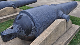
The Brooke rifle was a type of rifled, muzzle-loading naval and coast defense gun designed by John Mercer Brooke, an officer in the Confederate States Navy. They were produced by plants in Richmond, Virginia, and Selma, Alabama, between 1861 and 1865 during the American Civil War. They served afloat on Confederate ships and ashore in coast defense batteries operated by the Confederate States Army.

<span class="mw-page-title-main">St. Stephens, Alabama</span> CDP in Alabama, United States

St. Stephens is an unincorporated census-designated place in Washington County, Alabama, United States. Its population is 580. Located near the Tombigbee River in the southwestern part of the state and 67 miles north of Mobile, it is composed of two distinct sites: Old St. Stephens and New St. Stephens. The Old St. Stephens site lies directly on the river and is no longer inhabited. It was the territorial capital of the Alabama Territory. Now encompassed by the Old St. Stephens Historical Park, it is listed on the National Register of Historic Places.

<span class="mw-page-title-main">Alabama in the American Civil War</span>

Alabama was central to the Civil War, with the secession convention at Montgomery, the birthplace of the Confederacy, inviting other slaveholding states to form a southern republic, during January–March 1861, and to develop new state constitutions. The 1861 Alabaman constitution granted citizenship to current U.S. residents, but prohibited import duties (tariffs) on foreign goods, limited a standing military, and as a final issue, opposed emancipation by any nation, but urged protection of African-American slaves with trials by jury, and reserved the power to regulate or prohibit the African slave trade. The secession convention invited all slaveholding states to secede, but only 7 Cotton States of the Lower South formed the Confederacy with Alabama, while the majority of slave states were in the Union. Congress had voted to protect the institution of slavery by passing the Corwin Amendment on March 4, 1861, but it was never ratified.

Fort Charlotte, Mobile is a partially-reconstructed 18th-century fort in Mobile, Alabama.

<span class="mw-page-title-main">Fort Tombecbe</span> United States historic place

Fort Tombecbe, also spelled Tombecbee and Tombeché, was a stockade fort located on the Tombigbee River near the border of French Louisiana, in what is now Sumter County, Alabama. It was constructed under the leadership of Jean-Baptiste Le Moyne, Sieur de Bienville in 1736–1737 as trading post about 270 miles (430 km) upriver from Mobile, on an 80-foot (24 m) limestone bluff. Fort Tombecbe was built in Choctaw lands and would play a major role in colonial France's efforts to stop British intrusions into the area. Bienville claimed that the new fort was to protect the Choctaw from the Chickasaw. In May of 1736, Bienville, along with a force of 600 soldiers combined with a force of 600 Choctaw warriors, set out from Fort Tombecbe and attacked the Chickasaw near present-day Tupelo, Mississippi at the Battle of Ackia. Tombecbe was a major French outpost and trade depot among the Choctaw, the largest Native American group in the colony.

<span class="mw-page-title-main">36th Alabama Infantry Regiment</span> Infantry regiment of the Confederate States Army

The 36th Alabama Infantry Regiment was an infantry regiment that served in the Confederate Army during the American Civil War.

The Choctaw Corner is a former Native American boundary location near the modern border between Clarke and Marengo counties in Alabama, United States. It was established as the northernmost terminus for a mutually agreed upon boundary line between the Choctaw and Creek peoples during the Mississippi Territory period. This boundary line, now known as the “Old Indian Treaty Boundary,” starts at the Alabama River cut-off in southernmost Clarke County and follows a northward path through the county along the drainage divide between the Tombigbee and Alabama rivers to the Choctaw Corner, then turns ninety degrees to the west and follows the modern county-line between Clarke and Marengo to the Tombigbee River.

The Tombigbee District, also known as the Tombigbee, was one of two areas, the other being the Natchez District, that were the first in what was West Florida to be colonized by British subjects from the Thirteen Colonies and elsewhere. This later became the Mississippi Territory as part of the United States. The district was also the first area to be opened to white settlement in what would become the state of Alabama, outside of the French colonial outpost of Mobile on the Gulf Coast. The Tombigbee and Natchez districts were the only areas populated by whites in the Mississippi Territory when it was formed by the United States in 1798.

Agency is a ghost town located in Oktibbeha County, Mississippi, United States.

Lewis Thompson Woodruff was an officer in the Confederate States Army during the American Civil War. He was born in Hartford, Connecticut, but moved to Mobile, Alabama, in 1839. He entered Alabama state service on April 24, 1861, as captain of the "Mobile Rifles", which was designated Company K, 3rd Alabama Infantry. Woodruff was so well thought of that an offshoot of his company took his name, and the "Woodruff Rifles" fought in the 21st Alabama Infantry. The 3rd Alabama was organized at Montgomery, Alabama, and was the first Alabama regiment to make the trek to the seat of war in Virginia, where it mustered into Confederate service at Lynchburg on May 4.

Fort Carney was a stockade fort built in 1813 in present-day Clarke County, Alabama, during the Creek War.

<span class="mw-page-title-main">Fort Easley</span> United States historic site in Alabama

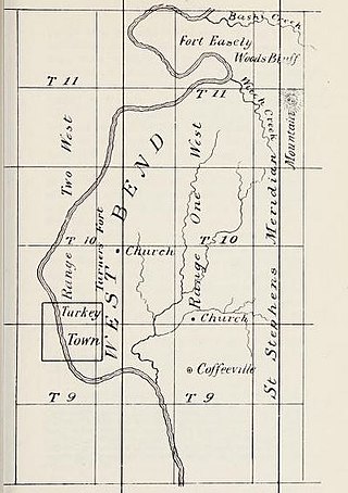
Fort Easley was a stockade fort built in 1813 in present-day Clarke County, Alabama during the Creek War.

<span class="mw-page-title-main">Ebenezer Farrand</span>

Ebenezer Farrand was an American Commodore that served in the Confederate States Navy and was notable for his service at the Battle of Drewry's Bluff as well as his ship construction at Selma, Alabama.

References

  1. U.S. Geological Survey Geographic Names Information System: Fort Stonewall
  2. 1 2 3 4 von Scheliha 1868, pp. 42.
  3. Murray, Jennifer M. "Battle of Mobile Bay". Encyclopedia of Alabama. Retrieved October 8, 2023.
  4. 1 2 3 Weaver 1983, pp. 86.
  5. 1 2 3 4 5 6 7 8 "National Register of Historic Places Multiple Property Documentation Form". Department of the Interior. Retrieved September 19, 2023.
  6. 1 2 3 4 5 Brannon, Peter A. (June 13, 1937). "Fort Stonewall at Choctaw Bluff". The Montgomery Advertiser. Retrieved September 17, 2023.
  7. Dumas 2015, pp. 155.
  8. 1 2 3 4 Bergeron 2000, pp. 61.
  9. 1 2 Williams 1981, pp. 170.
  10. von Scheliha 1868, pp. 42–43.
  11. Oliver, M. H. (March 10, 1863). "Request to be appointed surgeon for enslaved individuals working on defenses at Oven Bluff, Alabama". Letter to John Gill Shorter. Buyckville, Coosa County, Alabama. Retrieved September 17, 2023.
  12. Green 2012, pp. 7.
  13. 1 2 Williams 1981, pp. 110.
  14. Williams 1981, pp. 114.
  15. Williams 1981, pp. 171.
  16. Stephenson 2004, pp. 50.
  17. 1 2 Brannon, Peter A. (April 29, 1934). "Cannon". The Montgomery Advertiser. Retrieved September 17, 2023.
  18. Weaver 1983, pp. 87.
  19. "CSA Brooke Cannon S-96". Historical Marker Database. Retrieved October 6, 2023.
  20. 1 2 Lamar & Donnell 1987, pp. 12.

Sources