Dallas County, Alabama

Last updated

Dallas County
Dallas County Courthouse Selma Alabama 001.jpg
Dallas County Courthouse in Selma. Built in 1901, it was given an extensive modern makeover in 1960
Map of Alabama highlighting Dallas County.svg
Location within the U.S. state of Alabama
Alabama in United States.svg
Alabama's location within the U.S.
Coordinates: 32°19′29″N87°06′19″W / 32.3247°N 87.1053°W / 32.3247; -87.1053
CountryFlag of the United States.svg United States
StateFlag of Alabama.svg  Alabama
FoundedFebruary 9, 1818
Named for Alexander J. Dallas
Seat Selma
Largest citySelma
Area
  Total994 sq mi (2,570 km2)
  Land979 sq mi (2,540 km2)
  Water15 sq mi (40 km2)  1.5%
Population
 (2020)
  Total38,462
  Estimate 
(2023)
36,165 Decrease2.svg
  Density39/sq mi (15/km2)
Time zone UTC−6 (Central)
  Summer (DST) UTC−5 (CDT)
Congressional district 7th
Website www.dallascounty-al.org
  • County Number 27 on Alabama Licence Plates

Dallas County is a county located in the central part of the U.S. state of Alabama. As of the 2020 census, its population was 38,462. [1] The county seat is Selma. [2] Its name is in honor of United States Secretary of the Treasury Alexander J. Dallas, who served from 1814 to 1816.

Contents

Dallas County comprises the Selma, AL Micropolitan Statistical Area.

History

Dallas County was created by the Alabama territorial legislature on February 9, 1818, from Montgomery County. This was a portion of the Creek cession of lands to the US government of August 9, 1814. The Creek were known as one of the Five Civilized Tribes of the Southeast. The county was named for U.S. Treasury Secretary Alexander J. Dallas of Pennsylvania.

Dallas County is located in what has become known as the Black Belt region of the west-central portion of the state. The name referred to its fertile soil, and the area was largely developed for cotton plantations, worked by numerous enslaved African Americans in the antebellum period. After emancipation following the Civil War, many of the African Americans stayed in the area and worked as sharecroppers and tenant farmers. The county has been majority black since before the war.

Dallas County produced more cotton by 1860 than any other county in the state, requiring a large supply of workers, who were mostly enslaved. Dallas County slave owners on average had seventeen enslaved workers (compared to ten in Montgomery County, for instance); slave owners made up some 16% of the county's white population, but if their families are added, at least a third of the county's population was attached to a slaveholding family, according to historian Alston Fitts. [3]

Well-known local slaveowners include Washington Smith, owner of a big plantation in Bogue Chitto, Alabama, near Selma, and founder of the Bank of Selma. After Emancipation he continued to exert great influence over the African-American people in the county. [4] Shortly before the war, Smith had bought a West African girl, Redoshi, one of an illegal shipment of slaves in 1860. He called her Sally Smith. She was from Benin, kidnapped at age 12 and one of numerous African captives transported on the Clotilda to Mobile, Alabama, more than 50 years after the slave trade had been abolished. [5]

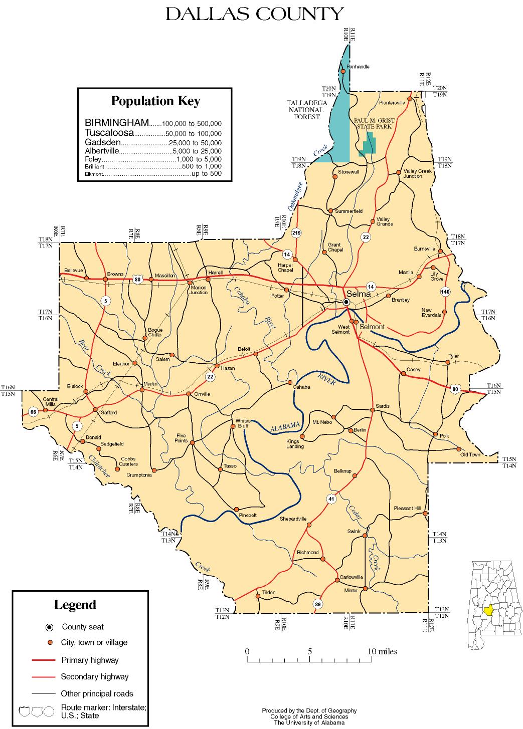
The county is traversed by the Alabama River, flowing from northeast to southwest across the county. It is bordered by Perry, Chilton, Autauga, Lowndes, Wilcox, and Marengo counties. Originally, the Dallas county seat was at Cahaba, which also served as the state capital for a brief period. In 1865, the county seat was transferred to Selma, Alabama as the center of population had moved. Other towns and communities in the still mostly rural county include Marion Junction, Sardis, Orrville, Valley Grande, and Minter.

20th century to present

Cotton production suffered in the early 20th century due to infestation of boll weevil, which invaded cotton areas throughout the South. At the turn of the 20th century, the state legislature disenfranchised most blacks and many poor whites through provisions of a new state constitution requiring payment of poll tax and passing a literacy test for voter registration. These largely survived legal challenges and blacks were excluded from the political system.

The period from 1877 to 1950 (and especially 1890 through 1930), was the height of lynchings across the South, as whites worked to impose white supremacy and Jim Crow. According to the third edition of Lynching in America, Dallas County had 19 lynchings in this period, the second-highest number of any county in the state after Jefferson County. [6] The lynching mobs killed suspects of alleged crimes, but also for behavior that offended a white man, and for labor organizing. [7] [6] In the early and mid-20th century, a total of 6.5 million blacks left the South in the Great Migration to escape these oppressive conditions.

In the postwar era of the 1950s and 1960s, African Americans, including many veterans, mounted new efforts across the South to be able to exercise their constitutional right as citizens to register and vote. [7]

The still mostly rural county reached a peak of population in 1960. Younger people have since left to seek work elsewhere. The county is working on new directions for economic development.

From 1963 through 1965, Selma and Dallas County were the sites of a renewed Voting Rights campaign. It was organized by locals of the Dallas County Voters League (DCVL), and joined by activists from Student Nonviolent Coordinating Committee (SNCC). In late 1964 they invited help from the Southern Christian Leadership Conference (SCLC); with SCLC president Martin Luther King Jr. participating, this campaign attracted national and international news in February and March 1965. They planned a march from Selma to the state capital of Montgomery, Alabama. Two activists were killed during demonstrations before the final march took place.

On March 7, several hundred peaceful marchers were beaten by state troopers and county posse after they passed over the Edmund Pettus Bridge and into the county, intending to march to the state capital of Montgomery. The events were covered by national media. The protesters renewed their walk on March 21, having been joined by thousands of sympathizers from across the country and gained federal protection, to complete the Selma to Montgomery marches. [8] More people joined them, so that some 25,000 people entered Montgomery on the last day of the march. In August of that year, Congress passed the Voting Rights Act of 1965, which was signed by President Lyndon B. Johnson. Millions of African-American citizens across the South have registered and voted in the subsequent years, participating again in the political system.

On March 5, 2018, Selma commemorated these marches. In addition, the city conducted a Community Remembrance Project, unveiling a new historic marker to memorialize the 19 African Americans who were lynched in Dallas County by whites during the late 19th and up to mid-20th century in acts of racial terrorism. This was done in cooperation with the Equal Justice Initiative, which published a report in 2015 that documented nearly 4,000 such lynchings, as well as Selma Center for Nonviolence Truth and Reconciliation at Healing Waters Retreat Center, Selma: Truth, Racial Healing & Transformation, and the Black Belt Community Foundation. [9]

Geography

According to the United States Census Bureau, the county has a total area of 994 square miles (2,570 km2), of which 979 square miles (2,540 km2) is land and 15 square miles (39 km2) (1.5%) is water. [10]

Adjacent counties

National protected areas

Transportation

Major highways

Airports

Demographics

Historical population
CensusPop.Note
1820 6,003
1830 14,017133.5%
1840 25,19979.8%
1850 29,72718.0%
1860 33,62513.1%
1870 40,70521.1%
1880 48,43319.0%
1890 49,3501.9%
1900 54,65710.8%
1910 53,401−2.3%
1920 54,6972.4%
1930 55,0940.7%
1940 55,2450.3%
1950 56,2701.9%
1960 56,6670.7%
1970 55,296−2.4%
1980 53,981−2.4%
1990 48,130−10.8%
2000 46,365−3.7%
2010 43,820−5.5%
2020 38,462−12.2%
2023 (est.)36,165 [11] −6.0%
U.S. Decennial Census [12]
1790–1960 [13] 1900–1990 [14]
1990–2000 [15] 2010–2020 [1]

2020 census

Dallas County, Alabama – Racial and Ethnic Composition
(NH = Non-Hispanic)
Note: the US Census treats Hispanic/Latino as an ethnic category. This table excludes Latinos from the racial categories and assigns them to a separate category. Hispanics/Latinos may be of any race.
Race / EthnicityPop 2000 [16] Pop 2010 [17] Pop 2020 [18] % 2000% 2010% 2020
White alone (NH)16,41712,67610,36335.41%28.93%26.94%
Black or African American alone (NH)29,20130,31426,81262.98%69.18%69.71%
Native American or Alaska Native alone (NH)4778560.10%0.18%0.15%
Asian alone (NH)1571441450.34%0.33%0.38%
Pacific Islander alone (NH)46120.01%0.01%0.03%
Some Other Race alone (NH)2615380.06%0.03%0.10%
Mixed Race/Multi-Racial (NH)2232787400.48%0.63%1.92%
Hispanic or Latino (any race)2903092960.63%0.71%0.77%
Total46,36543,82038,462100.00%100.00%100.00%

As of the census of 2020, there were 38,462 people, 15,910 households, and 10,328 families residing in the county.

2010 census

Residents identified by the following ethnicities, according to the 2010 United States census:

2000 census

As of the census [19] of 2000, there were 46,365 people, 17,841 households, and 12,488 families residing in the county. The population density was 47 people per square mile (18 people/km2). There were 20,450 housing units at an average density of 21 units per square mile (8.1 units/km2). The racial makeup of the county was 63.26% Black or African American, 35.58% White, 0.11% Native American, 0.35% Asian, 0.01% Pacific Islander, 0.14% from other races, and 0.55% from two or more races. 0.63% of the population were Hispanic or Latino of any race.

There were 17,841 households, out of which 33.50% had children under the age of 18 living with them, 40.40% were married couples living together, 25.40% had a female householder with no husband present, and 30.00% were non-families. Nearly 27.80% of all households were made up of individuals, and 11.60% had someone living alone who was 65 years of age or older. The average household size was 2.57 and the average family size was 3.15.

In the county, the population was spread out, with 28.60% under the age of 18, 9.40% from 18 to 24, 26.20% from 25 to 44, 21.90% from 45 to 64, and 13.90% who were 65 years of age or older. The median age was 35 years. For every 100 females, there were 83.50 males. For every 100 females age 18 and over, there were 77.80 males.

The median income for a household in the county was $23,370, and the median income for a family was $29,906. Males had a median income of $31,568 versus $18,683 for females. The per capita income for the county was $13,638. About 27.20% of families and 31.10% of the population were below the poverty line, including 40.70% of those under age 18 and 27.60% of those age 65 or over.

Government and politics

Dallas County is governed by a five-member county commission, elected from single-member districts.

Along with the rest of the Black Belt, Dallas County is solidly Democratic. Although African Americans supported the Republican Party during Reconstruction and into the early 20th century, they have supported Democratic candidates since the mid-1960s. No Republican has carried the county since Richard Nixon's 3,000-county-plus landslide in 1972.

United States presidential election results for Dallas County, Alabama [20]
Year Republican Democratic Third party
No.%No.%No.%
2020 5,52430.92%12,23068.46%1100.62%
2016 5,78930.81%12,83668.31%1670.89%
2012 6,28829.99%14,61269.70%640.31%
2008 6,79832.60%13,98667.07%680.33%
2004 7,33539.49%11,17560.17%630.34%
2000 7,36039.86%10,96759.40%1370.74%
1996 6,61237.45%10,50759.52%5353.03%
1992 7,39437.72%11,05356.38%1,1575.90%
1988 7,63043.79%9,66055.44%1330.76%
1984 9,58546.26%10,95552.88%1780.86%
1980 7,64742.14%9,77053.84%7304.02%
1976 7,14443.66%8,86654.19%3512.15%
1972 8,64460.53%5,42738.00%2091.46%
1968 1,2467.49%6,51639.17%8,87453.34%
1964 5,88889.12%00.00%71910.88%
1960 2,87256.94%2,10341.69%691.37%
1956 2,32443.37%2,12139.59%91317.04%
1952 2,55055.05%2,08244.95%00.00%
1948 1324.60%00.00%2,73895.40%
1944 1494.90%2,88394.74%110.36%
1940 1574.81%3,10695.10%30.09%
1936 491.50%3,20598.37%40.12%
1932 932.97%3,02796.62%130.41%
1928 70527.00%1,90572.96%10.04%
1924 502.36%1,94891.76%1255.89%
1920 782.81%2,70297.19%00.00%
1916 231.44%1,56597.87%110.69%
1912 161.06%1,46196.69%342.25%
1908 281.91%1,42097.06%151.03%
1904 362.36%1,47296.65%150.98%

Education

Areas not in Selma are served by Dallas County Schools, while areas in Selma are served by Selma City Schools.

Communities

Cities

Towns

Census-designated places

Unincorporated communities

Ghost town

Notable residents

Notable inhabitants

See also

Related Research Articles

<span class="mw-page-title-main">Montgomery County, Alabama</span> County in Alabama, United States

Montgomery County is located in the State of Alabama. As of the 2020 census, its population was 228,954, making it the seventh-most populous county in Alabama. Its county seat is Montgomery, the state capital. Montgomery County is included in the Montgomery Metropolitan Statistical Area.

<span class="mw-page-title-main">Bibb County, Alabama</span> County in Alabama, United States

Bibb County is a county in the central portion of the U.S. state of Alabama. The county is included in the ARC's definition of Appalachia. As of the 24th decennial 2020 census, its population was 22,293. The county seat is Centreville. The county is named in honor of William W. Bibb (1781–1820), the Governor of Alabama Territory (1817–1819) and the first Governor of Alabama. He is also the namesake for Bibb County, Georgia, where he began his political career. It is a "prohibition" or dry county; however, a few towns have become "wet" by allowing the sale of alcoholic beverages: Woodstock, West Blocton, Centreville, and Brent. The Bibb County Courthouse is located in the county seat of Centreville.

<span class="mw-page-title-main">Bullock County, Alabama</span> County in Alabama, United States

Bullock County is a county of the U.S. state of Alabama. As of the 2020 census, the population was 10,357. Union Springs was chosen as the county seat in 1867, and presently is the county's only incorporated city. The county was named for Confederate Army Colonel Edward C. Bullock who was a state senator and outspoken secessionist who died during the American Civil War.

<span class="mw-page-title-main">Calhoun County, Alabama</span> County in Alabama, United States

Calhoun County is a county in the east central part of the U.S. state of Alabama. As of the 2020 census, the population was 116,441. Its county seat is Anniston. It is named in honor of John C. Calhoun, a US Senator from South Carolina.

<span class="mw-page-title-main">Chilton County, Alabama</span> County in Alabama, United States

Chilton County is a county located in the central portion of the U.S. state of Alabama. As of the 2020 census, the population was 45,014. The county seat is Clanton. Its name is in honor of William Parish Chilton, Sr. (1810–1871), a lawyer who became Chief Justice of the Alabama Supreme Court and later represented Montgomery County in the Congress of the Confederate States of America.

<span class="mw-page-title-main">Etowah County, Alabama</span> County in Alabama, United States

Etowah County is a county located in the northeastern part of the U.S. state of Alabama. As of the 2020 census the population was 103,436. Its county seat is Gadsden. Its name is from a Cherokee word meaning "edible tree". In total area, it is the smallest county in Alabama, but one of the most densely populated. Etowah County comprises the Gadsden Metropolitan Statistical Area.

<span class="mw-page-title-main">Coosa County, Alabama</span> County in Alabama, United States

Coosa County is located in the east central portion of the U.S. state of Alabama. As of the 2020 census the population was 10,387. Its county seat is Rockford. Its name derives from a town of the Creek tribe and the Coosa River, which forms one of the county borders.

<span class="mw-page-title-main">Crenshaw County, Alabama</span> County in Alabama, United States

Crenshaw County is a county located in the south central portion of the U.S. state of Alabama. It is located immediately south of the Montgomery metropolitan area. As of the 2020 census, the population was 13,194. Its county seat is Luverne. Its name is in honor of an Alabama judge, Anderson Crenshaw.

<span class="mw-page-title-main">Henry County, Alabama</span> County in Alabama, United States

Henry County is a county in the southeastern part of the U.S. state of Alabama. As of the 2020 census, its population was 17,146. Its county seat is Abbeville. The county was named for Patrick Henry (1736–1799), famous orator and Governor of Virginia.

<span class="mw-page-title-main">Lowndes County, Alabama</span> County in Alabama, United States

Lowndes County is in the central part of the U.S. state of Alabama. As of the 2020 census, the county's population was 10,311. Its county seat is Hayneville. The county is named in honor of William Lowndes, a member of the United States Congress from South Carolina.

<span class="mw-page-title-main">Macon County, Alabama</span> County in Alabama, United States

Macon County is a county located in the east central part of the U.S. state of Alabama. As of the 2020 census, the population was 19,532. Its county seat is Tuskegee. Its name is in honor of Nathaniel Macon, a member of the United States Senate from North Carolina.

<span class="mw-page-title-main">Marengo County, Alabama</span> County in Alabama, United States

Marengo County is a county located in the west central portion of the U.S. state of Alabama. As of the 2020 census, the population was 19,323. The largest city is Demopolis, and the county seat is Linden. It is named in honor of the Battle of Marengo near Turin, Italy, where French leader Napoleon Bonaparte defeated the Austrians on June 14, 1800.

<span class="mw-page-title-main">Monroe County, Alabama</span> County in Alabama, United States

Monroe County is a county located in the southwestern part of the U.S. state of Alabama. As of the 2020 census, the population was 19,772. Its county seat is Monroeville. Its name is in honor of James Monroe, fifth President of the United States. It is a dry county, in which the sale of alcoholic beverages is restricted or prohibited, but Frisco City and Monroeville are wet cities.

<span class="mw-page-title-main">Perry County, Alabama</span> County in Alabama, United States

Perry County is a county located in the Black Belt region in the central part of the U.S. state of Alabama. As of the 2020 census, the population was 8,511. Its county seat is Marion. The county was established in 1819 and is named in honor of Commodore Oliver Hazard Perry of Rhode Island and the United States Navy. As of 2020, Perry County was the only county in Alabama, and one of 40 in the United States, not to have access to any wired broadband connections.

<span class="mw-page-title-main">Pickens County, Alabama</span> County in Alabama, United States

Pickens County is a county located on the west central border of the U.S. state of Alabama. As of the 2020 census, the population was 19,123. Its county seat is Carrollton, located in the center of the county. It is a prohibition, or dry county, although the communities of Carrollton and Aliceville voted to become wet in 2011 and 2012, respectively.

<span class="mw-page-title-main">Pike County, Alabama</span> County in Alabama, United States

Pike County is located in the U.S. state of Alabama. As of the 2020 census the population was 33,009. Its county seat is Troy. Its name is in honor of General Zebulon Pike, of New Jersey, who led an expedition to southern Colorado and encountered Pikes Peak in 1806.

<span class="mw-page-title-main">Wilcox County, Alabama</span> County in Alabama, United States

Wilcox County is a county of the U.S. state of Alabama. As of the 2020 census, the population was 10,600. Its county seat is Camden.

<span class="mw-page-title-main">Howard County, Missouri</span> County in Missouri, United States

Howard County is located in the U.S. state of Missouri, with its southern border formed by the Missouri River. As of the 2020 census, the population was 10,151. Its county seat is Fayette. The county was organized January 23, 1816, and named for Benjamin Howard, the first Governor of the Missouri Territory. Settled originally by migrants from the Upper South, it is part of the region historically known as Little Dixie. It is part of the Columbia, Missouri, metropolitan area.

<span class="mw-page-title-main">Selma, Alabama</span> City in Dallas County, Alabama, United States

Selma is a city in and the county seat of Dallas County, in the Black Belt region of south central Alabama and extending to the west. Located on the banks of the Alabama River, the city has a population of 17,971 as of the 2020 census. About 80% of the population is African-American.

<span class="mw-page-title-main">Black Belt (region of Alabama)</span> Region of Alabama originally named for black topsoil

The Black Belt is a region of the U.S. state of Alabama. The term originally referred to the region's rich, black soil, much of it in the soil order Vertisols. The term took on an additional meaning in the 19th century, when the region was developed for cotton plantation agriculture, in which the workers were enslaved African Americans. After the American Civil War, many freedmen stayed in the area as sharecroppers and tenant farmers, continuing to comprise a majority of the population in many of these counties.

References

  1. 1 2 "State & County QuickFacts". United States Census Bureau. Retrieved September 13, 2023.
  2. "Find a County". National Association of Counties. Archived from the original on May 31, 2011. Retrieved June 7, 2011.
  3. Fitts, Alston (2017). Selma: A Bicentennial History. University of Alabama Press. pp. 12–14. ISBN   9780817319328.
  4. Forner, Karlyn (2017). Why the Vote Wasn't Enough for Selma. Duke UP. p. 35. ISBN   9780822372233.
  5. Daley, Jason (April 5, 2019). "Researcher Identifies the Last Living Survivor of the Transatlantic Slave Trade". Smithsonian . Retrieved April 8, 2019.
  6. 1 2 "Lynching in America/Supplement: Lynchings by County, 3rd edition, Equal Justice Initiative, 2017" (PDF). Archived from the original (PDF) on October 23, 2017. Retrieved April 13, 2018.
  7. 1 2 Lynching in America: Confronting the Legacy of Racial Terror, 2015, Equal Justice Institute, Montgomery, Alabama
  8. Gary May, Bending Toward Justice: The Voting Rights Act and the Transformation of American Democracy (Basic Books, 2013)
  9. "Selma, Alabama Memorializes Lynching Victims", Equal Justice Initiative News, March 5, 2018; Accessed April 13, 2018
  10. "2010 Census Gazetteer Files". United States Census Bureau. August 22, 2012. Retrieved August 22, 2015.
  11. "Annual Estimates of the Resident Population for Counties: April 1, 2020 to July 1, 2023". United States Census Bureau. Retrieved March 27, 2024.
  12. "U.S. Decennial Census". United States Census Bureau. Retrieved August 22, 2015.
  13. "Historical Census Browser". University of Virginia Library. Archived from the original on August 11, 2012. Retrieved August 22, 2015.
  14. Forstall, Richard L., ed. (March 24, 1995). "Population of Counties by Decennial Census: 1900 to 1990". United States Census Bureau. Retrieved August 22, 2015.
  15. "Census 2000 PHC-T-4. Ranking Tables for Counties: 1990 and 2000" (PDF). United States Census Bureau. April 2, 2001. Retrieved August 22, 2015.
  16. "P004 HISPANIC OR LATINO, AND NOT HISPANIC OR LATINO BY RACE – 2000: DEC Summary File 1 – Dallas County, Alabama". United States Census Bureau .
  17. "P2 HISPANIC OR LATINO, AND NOT HISPANIC OR LATINO BY RACE – 2010: DEC Redistricting Data (PL 94-171) – Dallas County, Alabama". United States Census Bureau .
  18. "P2 HISPANIC OR LATINO, AND NOT HISPANIC OR LATINO BY RACE - 2020: DEC Redistricting Data (PL 94-171) – Dallas County, Alabama". United States Census Bureau .
  19. "U.S. Census website". United States Census Bureau . Retrieved May 14, 2011.
  20. "Dave Leip's Atlas of U.S. Presidential Elections" . Retrieved November 15, 2016.

32°19′29″N87°06′19″W / 32.32472°N 87.10528°W / 32.32472; -87.10528