Etowah County, Alabama

Last updated

Etowah County
Etowah County, Alabama Courthouse.JPG
Etowah County courthouse in Gadsden
Map of Alabama highlighting Etowah County.svg
Location within the U.S. state of Alabama
Alabama in United States.svg
Alabama's location within the U.S.
Coordinates: 34°03′00″N86°02′00″W / 34.05°N 86.033333333333°W / 34.05; -86.033333333333
CountryFlag of the United States.svg United States
StateFlag of Alabama.svg  Alabama
FoundedDecember 1, 1868
Seat Gadsden
Largest cityGadsden
Area
  Total549 sq mi (1,420 km2)
  Land535 sq mi (1,390 km2)
  Water14 sq mi (40 km2)  2.5%
Population
 (2020)
  Total103,436
  Estimate 
(2023)
103,241 Decrease2.svg
  Density190/sq mi (73/km2)
Time zone UTC−6 (Central)
  Summer (DST) UTC−5 (CDT)
Congressional district 4th
Website www.etowahcounty.org
  • County Number 31 on Alabama License Plates

Etowah County is a county located in the northeastern part of the U.S. state of Alabama. As of the 2020 census the population was 103,436. [1] Its county seat is Gadsden. [2] Its name is from a Cherokee word meaning "edible tree". In total area, it is the smallest county in Alabama, but one of the most densely populated. Etowah County comprises the Gadsden Metropolitan Statistical Area.

Contents

History

The area was split first among neighboring counties, with most of it belonging to DeKalb and Cherokee counties. [3] On December 7, 1866, the first postwar legislature separated and established Baine County, named for David W. Baine, a politician and Confederate military officer who died in battle in 1862. [4] The county seat was designated as Gadsden.

Because of postwar tensions and actions of insurgents against freedmen, at the state constitutional convention in 1868, the new county was abolished, replaced on December 1, 1868, by one aligned to the same boundaries and named Etowah County, from a Cherokee language word. [5] The Cherokee people in northeast Alabama had been forcibly removed in the 1830s to Indian Territory (now part of Oklahoma) west of the Mississippi River.

20th century to present

Etowah County had issues of racial discrimination and injustice, and Jim Crow. It had one documented lynching between 1877 and 1950, [6] which occurred in 1906. [7] Bunk Richardson, an innocent African-American, only because he was associated with a case in which a white woman was raped and killed. The whites were angry that the governor had commuted the death sentence of one defendant in the case (who was likely also innocent of charges), after two men had already been executed for the crime. [8]

An F4 tornado struck here on Palm Sunday March 27, 1994. It destroyed Piedmont's Goshen United Methodist Church twelve minutes after the National Weather Service of Birmingham issued a tornado warning for northern Calhoun, southeastern Etowah, and southern Cherokee counties.

Geography

According to the United States Census Bureau, the county has a total area of 549 square miles (1,420 km2), of which 535 square miles (1,390 km2) is land and 14 square miles (36 km2) (2.5%) is water. [9] It is the smallest county by area in Alabama.

Adjacent counties

Transportation

Transit

Major highways

Rail

Demographics

Historical population
CensusPop.Note
1870 10,109
1880 15,39852.3%
1890 21,92642.4%
1900 27,36124.8%
1910 39,10942.9%
1920 47,27520.9%
1930 63,39934.1%
1940 72,58014.5%
1950 93,89229.4%
1960 96,9803.3%
1970 94,144−2.9%
1980 103,0579.5%
1990 99,840−3.1%
2000 103,4593.6%
2010 104,4300.9%
2020 103,436−1.0%
2023 (est.)103,241 [10] −0.2%
U.S. Decennial Census [11]
1790–1960 [12] 1900–1990 [13]
1990–2000 [14] 2010–2020 [1]

2020 Census

Etowah County, Alabama – Racial and ethnic composition
Note: the US Census treats Hispanic/Latino as an ethnic category. This table excludes Latinos from the racial categories and assigns them to a separate category. Hispanics/Latinos may be of any race.
Race / Ethnicity (NH = Non-Hispanic)Pop 2000 [15] Pop 2010 [16] Pop 2020 [17] % 2000% 2010% 2020
White alone (NH)84,91982,78977,73182.08%79.28%75.15%
Black or African American alone (NH)15,12015,71614,99914.61%15.05%14.50%
Native American or Alaska Native alone (NH)3293723320.32%0.36%0.32%
Asian alone (NH)4286579210.41%0.63%0.89%
Pacific Islander alone (NH)2730390.03%0.03%0.04%
Some Other Race alone (NH)47872600.05%0.08%0.25%
Mixed Race or Multi-Racial (NH)8261,3324,2590.80%1.28%4.12%
Hispanic or Latino (any race)1,7633,4474,8951.70%3.30%4.73%
Total103,459104,430103,436100.00%100.00%100.00%

As of the 2020 United States census, there were 103,436 people, 40,053 households, and 25,177 families residing in the county.

2010 census

At the 2010 census there were 104,430 people, 42,036 households, and 28,708 families living in the county. The population density was 195 people per square mile (75 people/km2). There were 47,454 housing units at an average density of 86 units per square mile (33 units/km2). The racial makeup of the county was 80.3% White, 15.1% Black or African American, 0.4% Native American, 0.6% Asian, 0.2% Pacific Islander, 1.9% from other races, and 1.5% from two or more races. 3.3% of the population were Hispanic or Latino of any race. [18] Of the 42,036 households 27.1% had children under the age of 18 living with them, 49.3% were married couples living together, 14.3% had a female householder with no husband present, and 31.7% were non-families. 28.1% of households were one person and 11.9% were one person aged 65 or older. The average household size was 2.43 and the average family size was 2.97.

The age distribution was 23.0% under the age of 18, 8.5% from 18 to 24, 24.9% from 25 to 44, 27.8% from 45 to 64, and 15.8% 65 or older. The median age was 40.2 years. For every 100 females, there were 94.1 males. For every 100 females age 18 and over, there were 96.5 males.

The median household income was $36,422 and the median family income was $44,706. Males had a median income of $39,814 versus $30,220 for females. The per capita income for the county was $20,439. About 13.1% of families and 16.8% of the population were below the poverty line, including 24.6% of those under age 18 and 11.2% of those age 65 or over.

2000 census

At the 2000 census there were 103,459 people, 41,615 households, and 29,463 families living in the county. The population density was 193 people per square mile (75 people/km2). There were 45,959 housing units at an average density of 86 units per square mile (33 units/km2). The racial makeup of the county was 82.9% White, 14.7% Black or African American, 0.3% Native American, 0.4% Asian, <0.1% Pacific Islander, 0.7% from other races, and 0.9% from two or more races. 1.7% of the population were Hispanic or Latino of any race. [19] Of the 41,615 households 29.9% had children under the age of 18 living with them, 54.2% were married couples living together, 13.1% had a female householder with no husband present, and 29.2% were non-families. 26.3% of households were one person and 12.4% were one person aged 65 or older. The average household size was 2.44 and the average family size was 2.93.

The age distribution was 23.8% under the age of 18, 8.7% from 18 to 24, 27.4% from 25 to 44, 24.1% from 45 to 64, and 16.0% 65 or older. The median age was 38 years. For every 100 females, there were 91.80 males. For every 100 females age 18 and over, there were 87.90 males.

The median household income was $31,170 and the median family income was $38,697. Males had a median income of $31,610 versus $21,346 for females. The per capita income for the county was $16,783. About 12.3% of families and 15.7% of the population were below the poverty line, including 21.6% of those under age 18 and 13.7% of those age 65 or over.

Government

Etowah County is reliably Republican at the presidential level. The last Democrat to win the county in a presidential election is Bill Clinton, who won it by a plurality in 1996.

United States presidential election results for Etowah County, Alabama [20] [21]
Year Republican Democratic Third party
No.%No.%No.%
2020 35,52874.44%11,56724.24%6331.33%
2016 32,35373.26%10,44223.64%1,3693.10%
2012 29,13068.34%12,80330.04%6911.62%
2008 30,59568.39%13,49730.17%6451.44%
2004 26,99963.26%15,32835.91%3530.83%
2000 21,08753.59%17,43344.30%8282.10%
1996 16,83544.82%17,97647.86%2,7507.32%
1992 17,46741.15%20,55848.43%4,42610.43%
1988 17,82849.67%17,76249.49%3010.84%
1984 19,24349.62%19,07449.18%4641.20%
1980 16,17742.79%20,79054.99%8392.22%
1976 10,33328.90%25,02069.99%3971.11%
1972 20,85172.95%7,37225.79%3581.25%
1968 4,35113.95%4,61314.79%22,22271.26%
1964 12,89459.06%00.00%8,93940.94%
1960 7,12832.87%14,37266.28%1850.85%
1956 7,19836.20%12,37462.22%3141.58%
1952 4,63429.52%10,99770.06%660.42%
1948 1,61521.08%00.00%6,04678.92%
1944 1,52520.28%5,89578.38%1011.34%
1940 1,27015.27%7,01284.33%330.40%
1936 1,20717.30%5,73982.24%320.46%
1932 1,09317.29%5,16781.73%620.98%
1928 3,61258.88%2,48440.50%380.62%
1924 1,66433.17%3,08161.41%2725.42%
1920 3,21834.83%5,91764.05%1031.11%
1916 86230.51%1,88366.65%802.83%
1912 35412.22%1,51152.18%1,03135.60%
1908 99641.31%1,30954.29%1064.40%
1904 82332.71%1,43156.88%26210.41%
1900 1,62945.71%1,73448.65%2015.64%
1896 87331.18%1,78263.64%1455.18%
1892 2697.11%2,22558.85%1,28734.04%
1888 84129.95%1,91268.09%551.96%

Communities

Cities

Towns

Census-designated places

Unincorporated communities

Former city

See also

Related Research Articles

<span class="mw-page-title-main">Blount County, Alabama</span> County in Alabama, United States

Blount County is a county located in the U.S. state of Alabama. As of the 2020 census, the population was 59,134. Its county seat is Oneonta.

<span class="mw-page-title-main">Calhoun County, Alabama</span> County in Alabama, United States

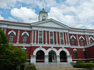
Calhoun County is a county in the east central part of the U.S. state of Alabama. As of the 2020 census, the population was 116,441. Its county seat is Anniston. It is named in honor of John C. Calhoun, a US Senator from South Carolina.

<span class="mw-page-title-main">Cherokee County, Alabama</span> County in Alabama, United States

Cherokee County, Alabama is a county located in the northeastern part of the U.S. state of Alabama. As of the 2020 census, the population was 24,971. Its county seat is Centre. The county is named for the Cherokee tribe.

<span class="mw-page-title-main">Cleburne County, Alabama</span> County in Alabama, United States

Cleburne County is a county located in the east central portion of the U.S. state of Alabama. As of the 2020 census, the population was 15,056. Its county seat is Heflin. Its name is in honor of Patrick R. Cleburne of Arkansas who rose to the rank of major general in the Confederate States Army. The eastern side of the county borders the state of Georgia.

<span class="mw-page-title-main">Marshall County, Alabama</span> County in Alabama, United States

Marshall County is a county of the state of Alabama, United States. As of the 2020 census the population was 97,612. Its county seat is Guntersville. A second courthouse is in Albertville. Its name is in honor of John Marshall, famous Chief Justice of the United States. Marshall County is a dry county, with the exception of the five cities of Albertville, Arab, Grant, Guntersville, and Boaz. Marshall County comprises the Albertville, AL Micropolitan Statistical Area, which is also included in the Huntsville-Decatur-Albertville, AL Combined Statistical Area.

<span class="mw-page-title-main">Talladega County, Alabama</span> County in Alabama, United States

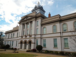
Talladega County is one of the sixty-seven counties located in the east central portion of the U.S. state of Alabama. As of the 2020 census, the population was 82,149. Its county seat is Talladega.

<span class="mw-page-title-main">Cherokee County, Georgia</span> County in Georgia, United States

Cherokee County is located in the US state of Georgia. As of the 2020 Census, the population was 266,620. The county seat is Canton. The county Board of Commissioners is the governing body, with members elected to office. Cherokee County is included in the Atlanta Metropolitan Area.

<span class="mw-page-title-main">Altoona, Alabama</span> Town in Alabama, United States

Altoona is a town in Etowah County in the U.S. state of Alabama. It is part of the Gadsden Metropolitan Statistical Area. At the 2020 census, the population was 948.

<span class="mw-page-title-main">Glencoe, Alabama</span> City in the United States

Glencoe is a city in Calhoun and Etowah counties in the U.S. state of Alabama. It is part of the Gadsden Metropolitan Statistical Area. The city incorporated in 1939. The population was 5,160 at the 2010 census.

<span class="mw-page-title-main">Southside, Alabama</span> City in Alabama, United States

Southside is a city located in Etowah County in the U.S. state of Alabama. It is included in the Gadsden Metropolitan Statistical Area. It incorporated in 1957. The population was 8,412 at the time of the 2010 United States Census. Located 8 to 12 miles south of downtown Gadsden, Southside is one of the fastest-growing cities in northeast Alabama. The current Mayor, elected in 2020, is Dana Snyder.

<span class="mw-page-title-main">Leesburg, Alabama</span> Town in Alabama, United States

Leesburg is a town in Cherokee County, Alabama, United States. At the 2020 census, the population was 911.

<span class="mw-page-title-main">Attalla, Alabama</span> City in Alabama, United States

Attalla is a city in Etowah County, Alabama, United States. As of the 2010 census, the population was 6,048.

<span class="mw-page-title-main">Gadsden, Alabama</span> City in Alabama, United States

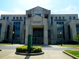
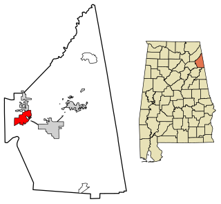
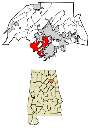
Gadsden is a city in and the county seat of Etowah County in the U.S. state of Alabama. It is located on the Coosa River about 56 miles (90 km) northeast of Birmingham and 90 miles (140 km) southwest of Chattanooga, Tennessee. It is the primary city of the Gadsden Metropolitan Statistical Area, which has a population of 103,931. The population 33,945 at the 2020 census.

<span class="mw-page-title-main">Hokes Bluff</span> City in Alabama, United States

Hokes Bluff is a city in Etowah County, Alabama, United States. It is part of the Gadsden Metropolitan Statistical Area. At the 2020 census, the population was 4,446.

<span class="mw-page-title-main">Rainbow City, Alabama</span> City in Alabama, United States

Rainbow City is a city in Etowah County, Alabama, United States. It incorporated in 1950. The population was 9,602 at the 2010 census. It is part of the Gadsden Metropolitan Statistical Area.

<span class="mw-page-title-main">Reece City, Alabama</span> Town in Alabama, United States

Reece City is a town in Etowah County, Alabama, United States. It was incorporated in May 1956. It is part of the Gadsden Metropolitan Statistical Area. At the 2020 census, the population was 615.

<span class="mw-page-title-main">Ridgeville, Alabama</span> Town in Alabama, United States

Ridgeville is a town in Etowah County, Alabama, United States. It incorporated in 1969 and is part of the Gadsden Metropolitan Statistical Area. At the 2020 census the population was 83, down from 158 in 2000. It is noteworthy for being the only community in Etowah County to have a black majority. Since 1970, it has also been the least populated community wholly within the county.

<span class="mw-page-title-main">Sardis City, Alabama</span> Town in Alabama, United States

Sardis City is a town in Etowah and Marshall counties in the U.S. state of Alabama. It is part of the Gadsden Metropolitan Statistical Area. It originally incorporated in May 1963 under the name of "Sardis". It became Sardis City in the 1980s. At the 2020 census, the population was 1,814.

<span class="mw-page-title-main">Walnut Grove, Alabama</span> Town in Alabama, United States

Walnut Grove is a town in Etowah County, Alabama, United States. It is part of the Gadsden Metropolitan Statistical Area. At the 2010 census the population was 698. From 1880 until the 1960 U.S. Census, with the exclusion of 1890 when no figure was reported, Walnut Grove had the distinction of being the least populated community wholly within Etowah County. It lost that distinction in 1970 to newly incorporated Ridgeville which has held the title since.

<span class="mw-page-title-main">St. Clair County, Alabama</span> County in Alabama, United States

St. Clair County is a county located in the central portion of the U.S. state of Alabama. As of the 2020 census, the population was 91,103. It has two county seats: Ashville and Pell City. It is one of two counties in Alabama, and one of 33 in the United States, with more than one county seat. Its name is in honor of General Arthur St. Clair, an officer in the French and Indian War. St. Clair County is included in the Birmingham, Alabama Metropolitan Statistical Area.

References

  1. 1 2 "State & County QuickFacts". United States Census Bureau. Retrieved September 12, 2023.
  2. "Find a County". National Association of Counties. Archived from the original on May 31, 2011. Retrieved June 7, 2011.
  3. "Alabama Census Year with Modern Map Overlayed," Maps of Alabama, Map of US.org, (https://www.mapofus.org/alabama/ Archived March 28, 2018, at the Wayback Machine : accessed February 15, 2017), Wordpress.com, 2017.>Interactive> 1860 & 1870
  4. Watson, Elbert L. (Summer 1968). "Lt. Colonel David W. Baine: A Confederate Hero from the North". Alabama Historical Quarterly. 30: 27–38. Retrieved May 22, 2017 via Internet Archive.
  5. "Alabama Counties: Etowah County". Alabama Department of Archives and History. Montgomery, AL: Alabama Department of Archives and History. October 25, 2011. Archived from the original on June 14, 2012. Retrieved April 30, 2012.
  6. "Lynching in America: Confronting the Legacy of Racial Terror – Supplement: Lynchings by County" (PDF) (second ed.). Equal Justice Initiative. 2015. Archived from the original (PDF) on April 10, 2016.
  7. "Why the story of a 1906 Alabama lynching won't be forgotten". Anniston/Gadsden Real-Time News. December 11, 2016.
  8. William Thornton, "Why the story of a 1906 Alabama lynching won't be forgotten", AL.com, December 11, 2016; accessed April 13, 2018
  9. "2010 Census Gazetteer Files". United States Census Bureau. August 22, 2012. Retrieved August 22, 2015.
  10. "Annual Estimates of the Resident Population for Counties: April 1, 2020 to July 1, 2023". United States Census Bureau. Retrieved March 27, 2024.
  11. "U.S. Decennial Census". United States Census Bureau. Retrieved August 22, 2015.
  12. "Historical Census Browser". University of Virginia Library. Retrieved August 22, 2015.
  13. Forstall, Richard L., ed. (March 24, 1995). "Population of Counties by Decennial Census: 1900 to 1990". United States Census Bureau. Retrieved August 22, 2015.
  14. "Census 2000 PHC-T-4. Ranking Tables for Counties: 1990 and 2000" (PDF). United States Census Bureau. April 2, 2001. Retrieved August 22, 2015.
  15. "P004 Hispanic or Latino, and Not Hispanic or Latino by Race – 2000: DEC Summary File 1 – Etowah County, Alabama". United States Census Bureau .
  16. "P2 Hispanic or Latino, and Not Hispanic or Latino by Race – 2010: DEC Redistricting Data (PL 94-171) – Etowah County, Alabama". United States Census Bureau .
  17. "P2 Hispanic or Latino, and Not Hispanic or Latino by Race – 2020: DEC Redistricting Data (PL 94-171) – Etowah County, Alabama". United States Census Bureau .
  18. "U.S. Census website". United States Census Bureau . Retrieved July 23, 2015.
  19. "U.S. Census website". United States Census Bureau . Retrieved May 14, 2011.
  20. "Dave Leip's Atlas of U.S. Presidential Elections" . Retrieved November 16, 2016.
  21. "Our Campaigns - U.S. President" . Retrieved January 22, 2021.

34°3′N86°2′W / 34.050°N 86.033°W / 34.050; -86.033