Geography of Alabama

Last updated

Physiographic regions in Alabama Physio-al.jpg
Physiographic regions in Alabama
Political Regions of Alabama AlaCounties.png
Political Regions of Alabama

The geography of Alabama describes a state in the Southeastern United States in North America. It extends from high mountains to low valleys and sandy beaches. Alabama is 30th in size and borders four U.S. states: Mississippi, Tennessee, Georgia, and Florida. It also borders the Gulf of Mexico.

Contents

Physical features

Extending entirely across the state of Alabama for about 20 miles (32 km) northern boundary, and in the middle stretching 60 miles (97 km) farther north, is the Cumberland Plateau, or Tennessee Valley region, broken into broad tablelands by the dissection of rivers. In the northern part of this plateau, west of Jackson county, there are about 1,000 square miles (2,600 km2) of level highlands from 700 to 800 feet (210 to 240 m) above sea level. South of these highlands, occupying a narrow strip on each side of the Tennessee River, is a country of gentle rolling lowlands varying in elevation from 500 to 800 feet (150 to 240 m). To the northeast of these highlands and lowlands is a rugged section with steep mountain-sides, deep narrow coves and valleys, and flat mountain-tops. Its elevations range from 400 to 1,800 feet (120 to 550 m). In the remainder of this region, the southern portion, the most prominent feature is Little Mountain, extending about 80 miles (129 km) from east to west between two valleys, and rising precipitously on the north side 500 feet (150 m) above them or 1,000 feet (300 m) above the sea.

Adjoining the Cumberland Plateau region on the southeast is the Appalachian Valley (locally known as Coosa Valley) region, which is the southern extremity of the Appalachian Mountains, and occupies an area within the state of about 8,000 square miles (21,000 km2). This is a limestone belt with parallel hard rock ridges left standing by erosion to form mountains. Although the general direction of the mountains, ridges, and valleys is northeast and southwest, irregularity is one of the most prominent characteristics. In the northeast are several flat-topped mountains, of which Raccoon and Lookout are the most prominent, having a maximum elevation near the Georgia line of little more than 1,800 feet (550 m) and gradually decreasing in height toward the southwest, where Sand Mountain is a continuation of Raccoon. South of these the mountains are marked by steep northwest sides, sharp crests and gently sloping southeast sides.

Southeast of the Appalachian Valley region, the Piedmont Plateau also crosses the Alabama border from the N.E. and occupies a small triangular-shaped section of which Randolph and Clay counties, together with the northern part of Tallapoosa and Chambers, form the principal portion. Its surface is gently undulating and has an elevation of about 1,000 feet (300 m) above sea level. The Piedmont Plateau is a lowland worn down by erosion on hard crystalline rocks, then uplifted to form a plateau.

The remainder of the state is occupied by the Coastal Plain. This is crossed by foothills and rolling prairies in the central part of the state, where it has a mean elevation of about 600 feet (180 m), becomes lower and more level toward the southwest, and in the extreme south is flat and but slightly elevated above the sea. The Cumberland Plateau region is drained to the west-northwest by the Tennessee River and its tributaries; all other parts of the state are drained to the southwest. In the Appalachian Valley region the Coosa River is the principal river; and in the Piedmont Plateau, the Tallapoosa River. In the Coastal Plain are the Tombigbee River in the west, the Alabama River (formed by the Coosa and Tallapoosa) in the western central, and in the east the Chattahoochee River, which forms almost half of the Georgia boundary. The Tombigbee and Alabama rivers unite near the southwest corner of the state, their waters discharging into Mobile Bay by the Mobile and Tensas rivers. The Black Warrior River is a considerable stream which joins the Tombigbee from the east.

The valleys in the north and northeast are usually deep and narrow, but in the Coastal Plain they are broad and in most cases rise in three successive terraces above the stream. The harbour of Mobile was formed by the drowning of the lower part of the valley of the Alabama and Tombigbee rivers as a result of the sinking of the land here, such sinking having occurred on other parts of the Gulf coast.


Flora and fauna

The fauna and flora of Alabama are similar to those of the Gulf states in general and have no distinctive characteristics. However, the Mobile River system has a high incidence of endemism among freshwater mollusks and biodiversity is high.

In Alabama, vast forests of pine constitute the largest proportion of the state's forest growth. There is also an abundance of cypress, hickory, oak, populus, and eastern redcedar trees. In other areas, hemlock growths in the north and southern white cedar in the southwest. Other native trees include ash, hackberry, and holly. In the Gulf region of the state grow various species of palmetto and palm. In Alabama there are more than 150 shrubs, including mountain laurel and rhododendron. Among cultivated plants are wisteria and camellia.

While in the past the state enjoyed a variety of mammals such as plains bison, eastern elk, North American cougar, bear, and deer, only the white-tailed deer remains abundant. Still fairly common are the bobcat, American beaver, muskrat, raccoon, Virginia opossum, rabbit, squirrel, red and gray foxes, and long-tailed weasel. Coypu and nine-banded armadillo have been introduced to the state and now also common.

Alabama's birds include golden and bald eagles, osprey and other hawks, yellow-shafted flickers, and black-and-white warblers. Game birds include bobwhite quail, duck, wild turkey, and goose. Freshwater fish such as bream, shad, bass, and sucker are common. Along the Gulf Coast there are seasonal runs of tarpon, pompano, red drum, and bonito. [1]

The U.S. Fish and Wildlife Service lists as endangered 99 animals, fish, and birds, and 18 plant species. [2] The endangered animals include the Alabama beach mouse, gray bat, Alabama red-bellied turtle, fin and humpback whales, bald eagle, and wood stork.

American black bear, racking horse, yellow-shafted flicker, wild turkey, Atlantic tarpon, largemouth bass, southern longleaf pine, eastern tiger swallowtail, monarch butterfly, Alabama red-bellied turtle, Red Hills salamander, camellia, oak-leaf hydrangea, peach, pecan, and blackberry are Alabama's state symbols.

Climate and soil

The climate of Alabama is humid subtropical. [3]

The heat of summer is tempered in the south by the winds from the Gulf of Mexico, and in the north by the elevation above the sea. The average annual temperature is highest in the southwest along the coast, and lowest in the northeast among the highlands. Thus at Mobile the annual mean is 67 °F (19 °C), the mean for the summer 81 °F (27 °C), and for the winter 52 °F (11 °C); and at Valley Head, in De Kalb county, the annual mean is 59 °F (15 °C), the mean for the summer 75 °F (24 °C), and for the winter 41 °F (5 °C). At Montgomery, in the central region, the average annual temperature is 66 °F (19 °C), with a winter average of 49 °F (9 °C), and a summer average of 81 °F (27 °C). The average winter minimum for the entire state is 35 °F (2 °C), and there is an average of 35 days in each year in which the thermometer falls below the freezing-point. At extremely rare intervals the thermometer has fallen below zero (-18 °C), as was the case in the remarkable cold wave of the 12th-13 February 1899, when an absolute minimum of −17 °F (−27 °C) was registered at Valley Head. The highest temperature ever recorded was 109 °F (43 °C) in Talladega county in 1902.

The amount of precipitation is greatest along the coast (62 inches/1,574 mm) and evenly distributed through the rest of the state (about 52 inches/1,320 mm). During each winter there is usually one fall of snow in the south and two in the north; but the snow quickly disappears, and sometimes, during an entire winter, the ground is not covered with snow. Heavy snowfall can occur, such as during the New Year's Eve 1963 snowstorm and the 1993 Storm of the Century. Hailstorms occur occasionally in the spring and summer, but are seldom destructive. Heavy fogs are rare, and are confined chiefly to the coast. Thunderstorms occur throughout the year - they are most common in the summer, but most severe in the spring and fall, when destructive winds and tornadoes occasionally occur. The prevailing winds are from the news. Hurricanes are quite common in the state, especially in the southern part, and major hurricanes occasionally strike the coast which can be very destructive.

As regards its soil, Alabama may be divided into four regions. Extending from the Gulf northward for about 150 miles (240 km) is the outer belt of the Coastal Plain, also called the Timber Belt, whose soil is sandy and poor, but responds well to fertilization. North of this is the inner lowland of the Coastal Plain, or the Black Prairie, which includes some 13,000 square miles (34,000 km2) and seventeen counties. It receives its name from its soil (weathered from the weak underlying limestone), which is black in colour, almost destitute of sand and loam, and rich in limestone and marl formations, especially adapted to the production of cotton; hence the region is also called the Cotton Belt. Between the Cotton Belt and the Tennessee Valley is the mineral region, the Old Land area—a region of resistant rocks—whose soils, also derived from weathering in silu, are of varied fertility, the best coming from the granites, sandstones and limestones, the poorest from the gneisses, schists and slates. North of the mineral region is the Cereal Belt, embracing the Tennessee Valley and the counties beyond, whose richest soils are the red clays and dark loams of the river valley; north of which are less fertile soils, produced by siliceous and sandstone formations.

Wetumpka Meteor Crater

Wetumpka is the home of "Alabama's greatest natural disaster." [4] A 1,000-foot (300 m)-wide [4] meteorite hit the area about 80 million years ago. The hills just east of downtown showcase the eroded remains of the five-mile (8.0 km) wide impact crater that was blasted into the bedrock, with the area labeled the Wetumpka crater or astrobleme ("star-wound") for the concentric rings of fractures and zones of shattered rock can be found beneath the surface. [5] In 2002, Christian Koeberl with the Institute of Geochemistry University of Vienna published evidence and established the site as an internationally recognized impact crater. [4]

Public lands

Alabama includes several types of public use lands. These include four national forests and one national preserve within state borders that provide over 25% of the state's public recreation land.

See also

Related Research Articles

<span class="mw-page-title-main">Alabama River</span> River in Alabama, United States

The Alabama River, in the U.S. state of Alabama, is formed by the Tallapoosa and Coosa rivers, which unite about 6 miles (10 km) north of Montgomery, near the town of Wetumpka.

<span class="mw-page-title-main">Wetumpka, Alabama</span> City in Alabama, United States

Wetumpka is a city in and the county seat of Elmore County, Alabama, United States. At the 2020 census, the population was 7,220. In the early 21st century Elmore County became one of the fastest-growing counties in the state. The city is considered part of the Montgomery Metropolitan Area.

<span class="mw-page-title-main">Chihuahuan Desert</span> Largest desert in North America

The Chihuahuan Desert is a desert ecoregion designation covering parts of northern Mexico and the southwestern United States. It occupies much of far West Texas, the middle to lower Rio Grande Valley and the lower Pecos Valley in New Mexico, and a portion of southeastern Arizona, as well as the central and northern portions of the Mexican Plateau. It is bordered on the west by the Sonoran Desert, the Colorado Plateau, and the extensive Sierra Madre Occidental range, along with northwestern lowlands of the Sierra Madre Oriental range. Its largest, continual expanse is located in Mexico, covering a large portion of the state of Chihuahua, along with portions of Coahuila, north-eastern Durango, the extreme northern part of Zacatecas, and small western portions of Nuevo León. With an area of about 501,896 km2 (193,783 sq mi), it is the largest desert in North America. The desert is fairly young, existing for only 8000 years.

<span class="mw-page-title-main">Tombigbee River</span> River in Alabama and Mississippi, United States

The Tombigbee River is a tributary of the Mobile River, approximately 200 mi (325 km) long, in the U.S. states of Mississippi and Alabama. Together with the Alabama, it merges to form the short Mobile River before the latter empties into Mobile Bay on the Gulf of Mexico. The Tombigbee watershed encompasses much of the rural coastal plain of western Alabama and northeastern Mississippi, flowing generally southward. The river provides one of the principal routes of commercial navigation in the southern United States, as it is navigable along much of its length through locks and connected in its upper reaches to the Tennessee River via the Tennessee-Tombigbee Waterway.

<span class="mw-page-title-main">Gulf Coastal Plain</span> Coastal Plain in the Southern United States and Eastern Mexico

The Gulf Coastal Plain extends around the Gulf of Mexico in the Southern United States and eastern Mexico.

<span class="mw-page-title-main">Cahaba River</span> River in Alabama, United States

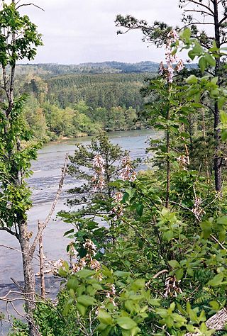
The Cahaba River is the longest substantially free-flowing river in Alabama and is among the most scenic and biologically diverse rivers in the United States. It is a major tributary of the Alabama River and part of the larger Mobile River basin. With headwaters near Birmingham, the Cahaba flows southwest, then at Heiberger turns southeast and joins the Alabama River at the ghost town and former Alabama capital of Cahaba in Dallas County. Entirely within central Alabama, the Cahaba River is 194 miles (312 km) long and drains an area of 1,870 square miles (4,800 km2). The name Cahaba is derived from the Choctaw words oka meaning "water" and aba meaning "above"

<span class="mw-page-title-main">Appalachian Plateau</span> Series of rugged dissected plateaus in the eastern United States

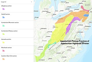
The Appalachian Plateau is a series of rugged dissected plateaus located on the western side of the Appalachian Mountains. The Appalachian Mountains are a range that run from Nova Scotia in Canada to Alabama in the United States.

<span class="mw-page-title-main">Appalachian mixed mesophytic forests</span> Temperate broadleaf and mixed forests ecoregion of the United States

The Appalachian mixed mesophytic forests is an ecoregion of the temperate broadleaf and mixed forests biome, as defined by the World Wildlife Fund. It consists of mesophytic plants west of the Appalachian Mountains in the Southeastern United States.

<span class="mw-page-title-main">Geography of Texas</span> Geographical features of Texas

The geography of Texas is diverse and large. Occupying about 7% of the total water and land area of the U.S., it is the second largest state after Alaska, and is the southernmost part of the Great Plains, which end in the south against the folded Sierra Madre Oriental of Mexico. Texas is in the South Central United States of America, and is considered to form part of the U.S. South and also part of the U.S. Southwest.

<span class="mw-page-title-main">Geography of Georgia (U.S. state)</span> United States of America state geography

Georgia is a state in the Southeastern United States in North America. The Golden Isles of Georgia lie off the coast of the state. The main geographical features include mountains such as the Ridge-and-valley Appalachians in the northwest, the Blue Ridge Mountains in the northeast, the Piedmont plateau in the central portion of the state and Coastal Plain in the south. The highest area in Georgia is Brasstown Bald which is 1,458 m (4,783 ft) above sea level, while the lowest is at sea level, at the Atlantic Ocean. Georgia is located at approximately 33° N 83.5° W. The state has a total area of 154,077 km2 (59,489 sq mi) and the geographic center is located in Twiggs County.

<span class="mw-page-title-main">Geography of New Mexico</span> Overview of the Geography of New Mexico

With a total area of 121,590 square miles (314,900 km2), New Mexico is the fifth-largest state, after Alaska, Texas, California, and Montana. Its eastern border lies along 103°W longitude with the state of Oklahoma, and 2.2 miles west of 103°W longitude with Texas. On the southern border, Texas makes up the eastern two-thirds, while the Mexican states of Chihuahua and Sonora make up the western third, with Chihuahua making up about 90% of that. The western border with Arizona runs along the 109° 03'W longitude. The southwestern corner of the state is known as the Bootheel. The 37°N parallel forms the northern boundary with Colorado. The states of New Mexico, Colorado, Arizona, and Utah come together at the Four Corners in New Mexico's northwestern corner. Its surface water area is about 292 square miles (760 km2).

<span class="mw-page-title-main">Geography of Arkansas</span>

The geography of Arkansas varies widely. The state is covered by mountains, river valleys, forests, lakes, and bayous in addition to the cities of Arkansas. Hot Springs National Park features bubbling springs of hot water, formerly sought across the country for their healing properties. Crowley's Ridge is a geological anomaly rising above the surrounding lowlands of the Mississippi embayment.

The U.S. state of Tennessee is geographically diverse, with varying terrains and several distinct physiographic regions. Its landforms range from the Blue Ridge Mountains in the eastern part of the state to flat and fertile plains along the Mississippi River. The state is geographically, legally, culturally, and economically divided into three Grand Divisions: East Tennessee, Middle Tennessee, and West Tennessee.

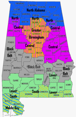
The geology of Alabama is marked by abundant geologic resources and a variety of geologic structures from folded mountains in the north to sandy beaches along the Gulf of Mexico coast. Alabama spans three continental geologic provinces as defined by the United States Geological Survey, the Atlantic Plain, Appalachian Highlands, and Interior Plains. The Geological Survey of Alabama breaks these provinces down into more specific physiographic provinces.

<span class="mw-page-title-main">Eastern Cascades Slopes and Foothills</span> Temperate coniferous forests ecoregion of the United States

The Eastern Cascades Slopes and Foothills ecoregion is a Level III ecoregion designated by the United States Environmental Protection Agency (EPA) in the U.S. states of Oregon, Washington, and California. In the rain shadow of the Cascade Range, the eastern side of the mountains experiences greater temperature extremes and receives less precipitation than the west side. Open forests of ponderosa pine and some lodgepole pine distinguish this region from the Cascades ecoregion, where hemlock and fir forests are more common, and from the lower, drier ecoregions to the east, where shrubs and grasslands are predominant. The vegetation is adapted to the prevailing dry, continental climate and frequent wildfire. Volcanic cones and buttes are common in much of the region.

<span class="mw-page-title-main">Blue Mountains (ecoregion)</span> Temperate coniferous forests ecoregion of the United States

The Blue Mountains ecoregion is a Level III ecoregion designated by the United States Environmental Protection Agency (EPA) in the Pacific Northwest, mainly in the state of Oregon, with small areas over the state border in Idaho and southeastern Washington. It is also contiguous with the World Wildlife Fund's Blue Mountain forests ecoregion.

<span class="mw-page-title-main">Columbia Plateau (ecoregion)</span> Xeric shrubland ecoregion of Canada and the United States

The Columbia Plateau ecoregion is a Level III ecoregion designated by the United States Environmental Protection Agency (EPA) encompassing approximately 32,100 square miles (83,139 km2) of land within the U.S. states of Washington, Oregon, and Idaho. The ecoregion extends across a wide swath of the Columbia River Basin from The Dalles, Oregon to Lewiston, Idaho to Okanogan, Washington near the Canada–U.S. border. It includes nearly 500 miles (800 km) of the Columbia River, as well as the lower reaches of major tributaries such as the Snake and Yakima rivers and the associated drainage basins. It is named for the Columbia Plateau, a flood basalt plateau formed by the Columbia River Basalt Group during the late Miocene and early Pliocene. The arid sagebrush steppe and grasslands of the region are flanked by moister, predominantly forested, mountainous ecoregions on all sides. The underlying basalt is up to 2 miles (3 km) thick and partially covered by thick loess deposits. Where precipitation amounts are sufficient, the deep loess soils have been extensively cultivated for wheat. Water from the Columbia River is subject to resource allocation debates involving fisheries, navigation, hydropower, recreation, and irrigation, and the Columbia Basin Project has dramatically converted much of the region to agricultural use.

<span class="mw-page-title-main">Northern Basin and Range ecoregion</span>

The Northern Basin and Range ecoregion is a Level III ecoregion designated by the United States Environmental Protection Agency (EPA) in the U.S. states of Oregon, Idaho, Nevada, Utah, and California. It contains dissected lava plains, rolling hills, alluvial fans, valleys, and scattered mountain ranges in the northern part of the Great Basin. Although arid, the ecoregion is higher and cooler than the Snake River Plain to the north and has more available moisture and a cooler climate than the Central Basin and Range to the south. Its southern boundary is determined by the highest shoreline of Pleistocene Lake Bonneville, which once inundated the Central Basin and Range. The western part of the region is internally drained; its eastern stream network drains to the Snake River system.

<span class="mw-page-title-main">Northeastern Highlands (ecoregion)</span>

The Northeastern Highlands ecoregion is a Level III ecoregion designated by the United States Environmental Protection Agency (EPA) in the U.S. states of Vermont, New Hampshire, Massachusetts, Maine, Connecticut, New York, New Jersey, and Pennsylvania. The ecoregion extends from the northern tip of Maine and runs south along the Appalachian Mountain Range into eastern Pennsylvania. Discontiguous sections are located among New York's Adirondack Mountains, Catskill Range, and Tug Hill. The largest portion of the Northeastern Highlands ecoregion encompasses several sub mountain ranges including the Berkshires, Green Mountains, Taconic, and White Mountains.

References

  1. Gall, Timothy L., ed. (2004), Worldmark Encyclopedia of the States (6 ed.), Thomson Gale, p. 2, ISBN   0-7876-7338-2, OCLC   53464095
  2. U.S. Fish and Wildlife Service, Threatened & Endangered Species System: Alabama , retrieved 2008-07-27
  3. The Alabama Climate Report Volume1, Number 1 October 2010
  4. 1 2 3 "Wetumpka Impact Crater" Archived 2007-09-28 at the Wayback Machine Wetumpka Public Library, accessed Aug. 21, 2007.
  5. "The Wetumpka Astrobleme" by John C. Hall, Alabama Heritage, Fall 1996, Number 42.