1993 Storm of the Century

Last updated

andtornado outbreaks of 1993
1993 Storm of the Century
Storm of the century satellite.gif
Satellite image by NASA of the storm on March 13, 1993, at 10:01 UTC.

The 1993 Storm of the Century (also known as the 93 Superstorm, The No Name Storm, or the Great Blizzard of '93/1993) was a cyclonic storm that formed over the Gulf of Mexico on March 12, 1993. The cold weather, heavy snowfall, high winds and storm surges that the storm brought affected a very large area; at its height, it stretched from Canada to Honduras. [1] The cyclone moved through the Gulf of Mexico and then through the eastern United States before moving on to eastern Canada. It eventually dissipated in the North Atlantic Ocean on March 15.

Contents

Heavy snow was first reported in highland areas as far south as Alabama and northern Georgia, with Union County, Georgia reporting up to 35 inches (89 cm) of snow. Birmingham, Alabama, reported a rare 13 in (33 cm) of snow. [2] [3] The Florida Panhandle reported up to around 6 inches to a foot of snow, [4] with hurricane-force wind gusts and record low barometric pressures. Between Louisiana and Cuba, the hurricane-force winds produced high storm surges across the Big Bend of Florida which, in combination with scattered tornadoes, killed dozens of people.

Record cold temperatures were seen across portions of the Southern United States and Eastern United States in the wake of this storm. In the United States, the storm was responsible for the loss of electric power to more than 10 million households. An estimated 40 percent of the country's population experienced the effects of the storm [5] and it led to a total of 208 fatalities. [1] In all, the storm resulted in 318 deaths, and caused $5.5 billion (1993 USD) in damages.

The greatest recorded snowfall amounts were at Mount Le Conte in Tennessee, where 56 inches (140 cm) of snow fell, and Mount Mitchell in North Carolina, the tallest mountain in eastern North America, where 50 inches (130 cm) were measured to fall and 15-foot (4.6 m) snow drifts were reported. [6]

Meteorological history

Map plotting the storm's track and intensity, according to the Saffir-Simpson scale

.mw-parser-output .hidden-begin{box-sizing:border-box;width:100%;padding:5px;border:none;font-size:95%}.mw-parser-output .hidden-title{font-weight:bold;line-height:1.6;text-align:left}.mw-parser-output .hidden-content{text-align:left}
Map key
Saffir-Simpson scale
.mw-parser-output .div-col{margin-top:0.3em;column-width:30em}.mw-parser-output .div-col-small{font-size:90%}.mw-parser-output .div-col-rules{column-rule:1px solid #aaa}.mw-parser-output .div-col dl,.mw-parser-output .div-col ol,.mw-parser-output .div-col ul{margin-top:0}.mw-parser-output .div-col li,.mw-parser-output .div-col dd{page-break-inside:avoid;break-inside:avoid-column}
.mw-parser-output .legend{page-break-inside:avoid;break-inside:avoid-column}.mw-parser-output .legend-color{display:inline-block;min-width:1.25em;height:1.25em;line-height:1.25;margin:1px 0;text-align:center;border:1px solid black;background-color:transparent;color:black}.mw-parser-output .legend-text{}
Tropical depression (<=38 mph, <=62 km/h)

Tropical storm (39-73 mph, 63-118 km/h)

Category 1 (74-95 mph, 119-153 km/h)

Category 2 (96-110 mph, 154-177 km/h)

Category 3 (111-129 mph, 178-208 km/h)

Category 4 (130-156 mph, 209-251 km/h)

Category 5 (>=157 mph, >=252 km/h)

Unknown
Storm type
Tropical cyclone
Subtropical cyclone
Extratropical cyclone, remnant low, tropical disturbance, or monsoon depression Superstorm 1993 track.png
Map plotting the storm's track and intensity, according to the Saffir–Simpson scale
Map key
  Tropical depression (≤38 mph, ≤62 km/h)
  Tropical storm (39–73 mph, 63–118 km/h)
  Category 1 (74–95 mph, 119–153 km/h)
  Category 2 (96–110 mph, 154–177 km/h)
  Category 3 (111–129 mph, 178–208 km/h)
  Category 4 (130–156 mph, 209–251 km/h)
  Category 5 (≥157 mph, ≥252 km/h)
  Unknown
Storm type
ArrowUp.svg Extratropical cyclone, remnant low, tropical disturbance, or monsoon depression
A satellite image of the Storm of the Century on March 13, 1993. 1993 storm century.jpg
A satellite image of the Storm of the Century on March 13, 1993.

A volcanic winter is thought to have started with the 1991 eruption of Mount Pinatubo. The temperature in the stratosphere rose to several degrees higher than normal, due to the absorption of radiation by the aerosol. The stratospheric cloud from the eruption persisted in the atmosphere for three years. The eruption, while not directly responsible, may have played a part in the formation of the 1993 Storm of the Century. [7]

During March 11 and 12, 1993, temperatures over much of the eastern United States began to drop as an arctic high pressure system built over the Midwestern United States and the Great Plains. Concurrently, an extratropical area of low pressure formed over Mexico along a stationary front draped west to east. By the afternoon of March 12, a defined airmass boundary was present along the deepening low. An initial burst of convective precipitation off the southern coast of Texas (facilitated by the transport of tropical moisture into the region) enabled initial intensification of the surface feature on March 12. Supported by a strong split-polar jet stream and a shortwave trough, the nascent system rapidly deepened. [8] The system's central pressure fell to 991 mbar (29.26 inHg) by 00:00 UTC on March 13. A powerful low-level jet over eastern Cuba and the Gulf of Mexico enhanced a cold front extending from the low southward to the Isthmus of Tehuantepec. Furthermore, the subtropical jet stream was displaced unusually far south, reaching into the Pacific Ocean near Central America and extending toward Honduras and Jamaica. Intense ageostrophic flow was noted over the southern United States, with winds flowing perpendicular to isobars over Louisiana. [8]

As the area of low pressure moved through the central Gulf of Mexico, a short wave trough in the northern branch of the jet stream fused with the system in the southern stream, which further strengthened the surface low. A squall line developed along the system's cold front, which moved rapidly across the eastern Gulf of Mexico through Florida and Cuba. [8] The cyclone's center moved into north-west Florida early on the morning of March 13, with a significant storm surge in the northwestern Florida peninsula that drowned several people. This initially caused the storm to be a blizzard but also cyclonic.

Barometric pressures recorded during the storm were low. Readings of 976.0 millibars (28.82 inHg) were recorded in Tallahassee, Florida, and even lower readings of 960.0 millibars (28.35  inHg ) were observed in New England. Low pressure records for March were set in areas of twelve states along the Eastern Seaboard, [9] with all-time low pressure records set between Tallahassee and Washington, D.C. [10] Snow began to spread over the eastern United States, and a large squall line moved from the Gulf of Mexico into Florida and Cuba. The storm system tracked up the East Coast during Saturday and into Canada by early Monday morning. In the storm's wake, unseasonably cold temperatures were recorded over the next two days in the Southeast.

Forecasting

Storm of the Century marked a milestone in the weather forecasting of the United States. By March 8, 1993, several operational numerical weather prediction models and medium-range forecasters at the United States National Weather Service recognized the threat of a significant snowstorm. This marked the first time National Weather Service meteorologists were able to predict accurately a system's severity five days in advance. Official blizzard warnings were issued two days before the storm arrived, as shorter-range models began to confirm the predictions. Forecasters were finally confident enough of the computer-forecast models to support decisions by several northeastern states to declare a state of emergency even before the snow started to fall. [11]

Impact

Partially dug out car at Fort Devens, Massachusetts, after the storm Superstorm9301.jpg
Partially dug out car at Fort Devens, Massachusetts, after the storm

The storm complex was large and widespread, affecting at least 26 US states and much of eastern Canada. It brought in cold air along with heavy precipitation and hurricane-force winds which, ultimately, caused a blizzard over the affected area; this also included thundersnow from Georgia to Pennsylvania and widespread whiteout conditions. Snow flurries were seen in the air as far south as Jacksonville, Florida, [12] and some areas of central Florida received a trace of snow. The storm severely impacted both ground and air travel. Airports were closed all along the eastern seaboard, and flights were cancelled or diverted, thus stranding many passengers along the way. Every airport from Halifax, Nova Scotia, to Tampa was temporarily closed due to the storm. Highways were also closed or restricted all across the affected region, even in states generally well prepared for snow emergencies.[ citation needed ]

Snowstorm Totals
Totals are for the main system only.
PlaceTotal
Mount LeConte, TN 56 inches (140 cm) [13]
Mount Mitchell, NC 50 inches (130 cm) [14]
Snowshoe, WV 44 in (110 cm) [15]
Syracuse, NY 43 in (110 cm) [15]
Tobyhanna, PA 42 in (110 cm) [15]
Lincoln, NH 35 in (89 cm) [15]
Blairsville, GA 35 in (89 cm) [3]
Boone, NC 33 in (84 cm)
Gatlinburg, TN 30 in (76 cm) [15]
Pittsburgh, PA 25.2 in (64 cm)
Chattanooga, TN 23 in (58 cm) [15]
London, KY 22 in (56 cm) [16]
Worcester, MA 20.1 in (51 cm) [17]
Ottawa, ON 17.7 in (45 cm) [18]
Birmingham, AL 13 in (33 cm) [19]
Montreal, QC 16.1 in (41 cm) [20]
Knoxville, TN 15 in (38 cm)
Trenton, NJ 14.8 in (38 cm)
Dulles, VA (25 miles NW of Washington, D.C.)14.1 in (36 cm)
Birmingham, AL 13 in (33 cm) [21]
Boston, MA 12.8 in (33 cm)
New York, NY (LaGuardia)12.3 in (31 cm)
Baltimore, MD (BWI)11.9 in (30 cm)
Atlanta, GA (northern suburbs) 10.0 in (25 cm)
Huntsville, AL 7 in (18 cm) [22]
Tallahassee, FL 6 in (16 cm)
Atlanta, GA (Hartsfield International Airport)4.5 in (11 cm) [15]
Mobile, AL 3 in (7.6 cm)

Some affected areas in the Appalachian Mountain region saw 5 feet (1.5 m) of snow, and snowdrifts as high as 35 feet (11 m). Mount Le Conte, Tennessee recorded 56" and Mount Mitchell, NC recorded 50 in (130 cm) of snowfall. The volume of the storm's total snowfall was later computed to be 12.91 cubic miles (53.8 km3), an amount which would weigh (depending on the variable density of snow) between 5.4 and 27 billion tons.[ citation needed ]

The weight of the record snowfalls collapsed several factory roofs in the South; and snowdrifts on the windward sides of buildings caused a few decks with substandard anchoring to fall from homes. Though the storm was forecast to strike the snow-prone Appalachian Mountains, hundreds of people were nonetheless rescued from the Appalachians, many caught completely off guard on the Appalachian Trail or in cabins and lodges in remote locales. Snowdrifts up to 14 feet (4.3 m) were observed at Mount Mitchell. Snowfall totals of between 2 and 3 feet (0.61 and 0.91 m) were widespread across northwestern North Carolina. Boone, North Carolina—in a high-elevation area accustomed to heavy snowfalls—was nonetheless caught off-guard by more than 30 inches (76 cm) of snow and 24 hours of temperatures below 11 °F (−12 °C). Boone's Appalachian State University closed that week, for the first time in its history. Stranded motorists at Deep Gap broke into Parkway Elementary School to survive, and National Guard helicopters dropped hay in fields to keep livestock from starving in northern N.C. mountain counties.[ citation needed ]

In Virginia, the LancerLot sports arena in Vinton collapsed due to the weight of the record snowfall, forcing the Virginia Lancers of the ECHL to relocate to nearby Roanoke and become the Roanoke Express. Also collapsing were the roofs of a Lowe's store in Christiansburg and the Dedmon Center, at Radford University. Thousands of travelers were stranded along interstate highways in Southwest Virginia. [23] Electricity was not restored to many isolated rural areas for up to three weeks, with power outages occurring all over the east. Nearly 60,000 lightning strikes were recorded as the storm swept over the country for a total of 72 hours. As one of the most powerful, complex storms in recent history, this storm was described as the "Storm of the Century" by many of the areas affected.[ citation needed ]

A hockey game hosted by the Philadelphia Flyers against the Los Angeles Kings was postponed due to a large window breaking from wind gusts just before the end of the first period. [24]

Gulf of Mexico

The United States Coast Guard dealt with "absolutely incredible, unbelievable" conditions within the Gulf of Mexico. The 200-foot (61 m) freighter Fantastico sank 70 miles (110 km) off Ft. Myers, Florida, and seven of her crew died when a Coast Guard helicopter was forced back to base due to low fuel levels after rescuing three of her crew. The 147-foot (45 m) freighter Miss Beholden ran aground on a coral reef 10 miles (16 km) from Key West, Florida. Several other smaller vessels sank in the rough seas. In all, the Coast Guard rescued 235 people from over 100 boats across the Gulf of Mexico during the tempest. [25]

Florida

The Derecho moves into the Florida coast during the overnight hours of March 13, 1993 1993 fl derecho.jpg
The Derecho moves into the Florida coast during the overnight hours of March 13, 1993
NOAA estimate of storm surges along Florida's Gulf Coast, March 13, 1993. Superstorm surge.jpg
NOAA estimate of storm surges along Florida's Gulf Coast, March 13, 1993.

Besides producing record-low barometric pressure across a swath of the Southeast and Mid-Atlantic states, and contributing to one of the nation's biggest snowstorms, the low produced a potent squall line ahead of its cold front. The squall line produced a serial derecho as it moved into Florida and Cuba shortly after midnight on March 13. Straight-line winds gusted above 100 miles per hour (87 kn; 160 km/h) at many locations in Florida as the squall line moved through. A substantial tree fall was seen statewide from this system. The supercells in the derecho produced eleven tornadoes. The first tornado was an F2 that touched down in Chiefland at 04:38 UTC on March 13, damaging several mobile homes and downing trees and power lines. Three people were killed and seven people sustained injures. Around the same time, an F1 tornado was spawned near Crystal River. After moving eastward into the town, the twister damaged 15 homes, several of them severely. A total of three people were injured. The next tornado was a waterspout that moved ashore over Treasure Island around 05:00 UTC. Rated F0, the tornado deroofed one home, damaged several others, and impacted a few boats. [27]

Around 05:04 UTC, an F0 tornado was reported in New Port Richey, damaging several homes and injuring 11 people. About 16 minutes later, an F2 tornado formed to the southwest of Ocala. Many trees fell and several storage buildings and a warehouse suffered extensive damage, while one hangar was destroyed and two others received major damage at the Ocala International Airport. At 05:20 UTC, approximately the same time as the Ocala tornado, another twister rated F1 touched down near LaCrosse. Several trees and power lines were downed and a few homes were destroyed, one from a propane explosion. One person was killed and four others received injuries. About 10 minutes later, another F2 twister was spawned near Howey-in-the-Hills. It moved through Mount Dora, destroying 13 homes, substantially damaging 80 homes, and inflicting minor damage on 266 homes. One person, a 5-month-old baby, was killed, while two others were injured. [27]

At 05:30 UTC, a waterspout-turned F0 tornado tossed a 23 ft (7.0 m) sailboat about 300 ft (91 m) at the Davis Islands yacht club in Tampa, while five other boats broke loose from their cradles and twelve were smashed into the seawall. About 30 minutes later, an F1 tornado formed in Jacksonville, demolishing four dwellings and damaging sixteen others. [27] Also at 06:00 UTC, an F0 tornado spawned near Bartow snapped a few trees and damaged a few doors. The eleventh and final tornado developed in Jacksonville at 06:10 UTC. The twister damaged a few trees near the Jacksonville International Airport. At the airport itself, the tornado damaged several jetways and service vehicles, while a Boeing 737 was pushed about 40 ft (12 m). [27]

A substantial storm surge was also generated along the gulf coast from Apalachee Bay in the Florida Panhandle to north of Tampa Bay. Due to the angle of the coast relative to the approaching squall, Taylor County along the eastern portion of Apalachee Bay and Hernando County north of Tampa were especially hard-hit. [4]

Storm surges in those areas reached up to 12 feet (3.7 m), [26] higher than many hurricanes. With little advance warning of incoming severe conditions, some coastal residents were awakened in the early morning of March 13 by the waters of the Gulf of Mexico rushing into their homes. [28] More people died from drowning in this storm than during Hurricanes Hugo and Andrew combined. [5] Overall, the storm's surge, winds, and tornadoes damaged or destroyed 18,000 homes. [29] A total of 47 people died in Florida due to this storm. [4]

Despite all the rainfall and tornadoes, lots of snow also dropped in the Panhandle regions of Florida. Areas saw snow of up to 1 foot near the coast and inland. In Tallahassee, around 1 to 2 inches of snow were dropped to the ground. In Jacksonville and Fernandina beach, traces of snow were seen in the air. Very cold temperatures were also seen in the state. Snow was seen as far south as Tampa Bay in central Florida. Tallahassee's lowest temperature was 17 degrees F (-8 degrees C) On March 13, Orlando saw 26 degrees F (-3 degrees C), and Miami saw 39 degrees F (4 degrees C ) That same day. In Orlando, there were mixed precipitations with rain, sleet and snow combined. Miami saw near record cold temperatures for the month of March, making it a very rare phenomenon for Florida. Florida is usually mild all year round so it was rare.

Cuba

In Cuba, wind gusts reached 100 mph (160 km/h) in the Havana area. A survey conducted by a research team from the Institute of Meteorology of Cuba suggests that the maximum winds could have been as high as 130 mph (210 km/h). It is the most damaging squall line ever recorded in Cuba.

There was widespread and significant damage in Cuba, with damage estimated as intense as F2. [8] The squall line finally moved out of Cuba near sunrise, leaving 10 deaths and US$1 billion in damage on the island.

North Atlantic

The cargo ship Gold Bond Conveyor en route from Halifax, Nova Scotia, Canada to Tampa, Florida foundered in the Atlantic Ocean 60 nautical miles (110 kilometres) SE of Sable Island, Nova Scotia with the loss of all 33 crew. [30] It is thought that water entered the hold where gypsum ore was being stored and caused the rock to shift and harden. This instability compounded with winds of 90 miles per hour (140 km/h) and 100-foot (30 m) waves led to her sinking. The Liberian-flagged ship was owned by Skaarup Shipping Corp., of Greenwich, Connecticut, and under charter to National Gypsum Co., a U.S. company. The ship had previously survived the Perfect Storm of 1991 two years earlier. [31]

Tornadoes spawned by the storm

Confirmed tornadoes by Fujita rating
FUF0F1F2F3F4F5Total
044300011
F# LocationCountyTime (UTC)Path lengthFatalities
Florida
F2NW of Chiefland Levy 04381 mile (1.6 km)3 deaths
F1E of Crystal River Citrus 04380.5 miles (0.80 km)
F0 Treasure Island Pinellas 05000.2 miles (0.32 km)
F0 New Port Richey area Pasco 05040.1 miles (0.16 km)
F2 Ocala area Marion 052015 miles (24 km)
F1N of LaCrosse Alachua 05200.8 miles (1.3 km)1 death
F2NW of Howey-in-the-Hills to Altamonte Springs Lake 053030 miles (48 km)1 death
F1 Tampa area Hillsborough 05300.6 miles (0.97 km)
F1 Jacksonville area (1st tornado) Duval 06000.8 miles (1.3 km)
F0 Bartow area Polk 06000.1 miles (0.16 km)
F0 Jacksonville area (2nd tornado) Duval 06100.1 miles (0.16 km)
Sources:
Tornado History Project Storm Data – March 12, 1993, Tornado History Project Storm Data – March 13, 1993

See also

Related Research Articles

<span class="mw-page-title-main">Blizzard</span> Type of snowstorm

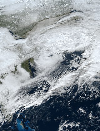
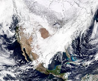
A blizzard is a severe snowstorm characterized by strong sustained winds and low visibility, lasting for a prolonged period of time—typically at least three or four hours. A ground blizzard is a weather condition where snow is not falling but loose snow on the ground is lifted and blown by strong winds. Blizzards can have an immense size and usually stretch to hundreds or thousands of kilometres.

<span class="mw-page-title-main">North American blizzard of 2003</span>

The Blizzard of 2003, also known as the Presidents' Day Storm II or simply PDII, was a historic and record-breaking snowstorm on the East Coast of the United States and Canada, which lasted from February 14 to February 19, 2003. It spread heavy snow across the major cities of the Northeastern and Mid-Atlantic states, making it the defining snowstorm of the very snowy winter of 2002–2003.

This article describes severe weather terminology used by the Meteorological Service of Canada, a branch within Environment and Climate Change Canada. The article primarily describes various weather warnings, and their criteria. Related weather scales and general weather terms are also addressed in this article. Some terms are specific to certain regions.

<span class="mw-page-title-main">Great Storm of 1975</span> Storm system in Central and Southeastern United States in 1975

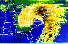
The Great Storm of 1975 was an intense storm system that impacted a large portion of the Central and Southeast United States from January 9 to January 12, 1975. The storm produced 45 tornadoes in the Southeast U.S. resulting in 12 fatalities, while later dropping over 2 feet (61 cm) of snow and killing 58 people in the Midwest. This storm remains one of the worst blizzards to ever strike parts of the Midwest, as well as one of the largest January tornado outbreaks on record in the United States.

The Early Winter 2006 North American storm complex was a severe winter storm that occurred on November 26, 2006, and continued into December 1. It affected much of North America in some form, producing various kinds of severe weather including a major ice storm, blizzard conditions, high winds, extreme cold, a serial derecho and some tornadoes.

<span class="mw-page-title-main">March 2014 North American winter storm</span> Winter storm in 2014

The March 2014 North American winter storm, also unofficially referred to as Winter Storm Titan, was an extremely powerful winter storm that affected much of the United States and portions of Canada. It was one of the most severe winter storms of the 2013–14 North American winter storm season, storm affecting most of the Western Seaboard, and various parts of the Eastern United States, bringing damaging winds, flash floods, and blizzard and icy conditions.

<span class="mw-page-title-main">2013–14 North American winter</span>

The 2013–14 North American winter was one of the most significant for the United States, due in part to the breakdown of the polar vortex in November 2013, which allowed very cold air to travel down into the United States, leading to an extended period of very cold temperatures. The pattern continued mostly uninterrupted throughout the winter and numerous significant winter storms affected the Eastern United States, with the most notable one being a powerful winter storm that dumped ice and snow in the Southeastern United States and the Northeastern United States in mid-February. Most of the cold weather abated by the end of March, though a few winter storms did affect the Western United States towards the end of the winter.

<span class="mw-page-title-main">2015–16 North American winter</span>

The 2015–16 North American winter was not as frigid across North America and the United States as compared to the 2013–14 and 2014–15 winters. This was mainly due to a strong El Niño, which caused generally warmer-than-average conditions. However, despite the warmth, significant weather systems still occurred, including a snowstorm and flash flooding in Texas at the end of December and a large tornado outbreak at the end of February. The main event of the winter season, by far and large, was when a crippling and historic blizzard struck the Northeastern United States in late January, dumping up to 3 feet of snow in and around the metropolitan areas. Several other smaller snow events affected the Northeast as well, but for the most part the heaviest snowstorms and ice stayed out further west, such as a severe blizzard in western Texas in late December, and a major late-season snowstorm in Colorado in mid-April.

<span class="mw-page-title-main">December 2015 North American storm complex</span> 2015 massive storm system that affected North America

The December 2015 North American storm complex, also known as Winter Storm Goliath, was a major storm complex that produced a tornado outbreak, a winter storm, a blizzard and an ice storm in areas ranging from the Southwestern United States to New England. Tornadoes struck the Dallas–Forth Worth metroplex in Texas while several other states, especially Missouri, were affected by heavy rain and snow causing severe floods. As the system moved through the Great Lakes, heavy rain, ice pellets and heavy snow fell in the entire region. Wintry mix moved through southern Ontario and Quebec had significant snowfall on December 29. Almost 60 people were killed during the storm system's progression and aftermath, making it one of the deadliest such systems of 2015 in the United States.

<span class="mw-page-title-main">2012–13 North American winter</span>

The 2012–13 North American winter started out somewhat early, as the remnants of Hurricane Sandy brought heavy snow to the mountains of West Virginia in late October. Later, a strong nor'easter affected the weary Northeastern United States, hampering storm recovery efforts and dropping several inches of snow. The rest of the winter featured several other notable events, such as a Christmas winter storm that affected most of the Eastern United States, and the most notable event occurring in early February, when a powerful blizzard struck the Northeast and brought record snow to some areas. During the winter, a weak El Nino was expected to influence weather conditions across the continent.

<span class="mw-page-title-main">2010–11 North American winter</span>

The 2010–11 North American winter was influenced by an ongoing La Niña, seeing winter storms and very cold temperatures affect a large portion of the Continental United States, even as far south as the Texas Panhandle. Notable events included a major blizzard that struck the Northeastern United States in late December with up to 2 feet (24 in) of snowfall and a significant tornado outbreak on New Year's Eve in the Southern United States. By far the most notable event was a historic blizzard that impacted areas from Oklahoma to Michigan in early February. The blizzard broke numerous snowfall records, and was one of the few winter storms to rank as a Category 5 on the Regional Snowfall Index. In addition, Oklahoma set a statewide low temperature record in February.

<span class="mw-page-title-main">2016–17 North American winter</span>

The 2016–17 North American winter was quite warm across North America in general, due in part to a weak La Niña that was expected to influence weather conditions across the continent. Several notable events occurred during the season, including a potent winter storm that affected the East Coast of the United States in early January, the second-largest winter tornado outbreak on record later that month, and an unusually warm February. In addition, towards the end of the season, a large cyclonic storm system that caused a large tornado outbreak, flooding, and a potent blizzard occurred in the Heartland of the country. However, the most notable event of the winter was a powerful blizzard that impacted the Northeast and New England in mid-March, towards the end of the season.

<span class="mw-page-title-main">2017–18 North American winter</span> Weather summary

The 2017–18 North American winter saw weather patterns across North America that were very active, erratic, and protracted, especially near the end of the season, resulting in widespread snow and cold across the continent during the winter. Significant events included rare snowfall in the South, an outbreak of frigid temperatures that affected the United States during the final week of 2017 and early weeks of January, and a series of strong nor'easters that affected the Northeastern United States during the month of March. In addition, flooding also took place during the month of February in the Central United States. Finally the winter came to a conclusion with a powerful storm system that caused a tornado outbreak and blizzard in mid-April. The most intense event, however, was an extremely powerful cyclonic blizzard that impacted the Northeastern United States in the first week of 2018. Similar to the previous winter, a La Niña was expected to influence the winter weather across North America.

<span class="mw-page-title-main">March 2019 North American blizzard</span> Colorado Low storm

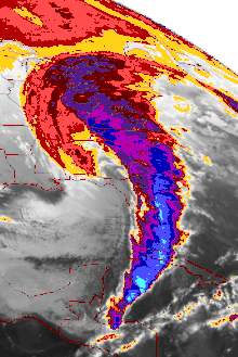
The March 2019 North American blizzard was a powerful Colorado Low that produced up to two feet of snow in the plains and Midwest. Rapid snowmelt following the storm caused historic flooding, and some areas received hurricane-force wind gusts. Comparable to the 1993 Storm of the Century, the storm was labeled a bomb cyclone after barometric pressure readings dropped in excess of 24 mbar (0.71 inHg) over a 24-hour period. After the storm entered Colorado from its origination in Arizona, the pressure dropped more than 30 mbar (0.89 inHg) and rapidly intensified over the western High Plains. The severe storm set new all-time record low barometric pressure readings in Colorado, Kansas and New Mexico. The storm itself killed only one person in Colorado, but flooding caused by the storm killed at least 3, one in Iowa and at least two in Nebraska and left ~140,000 without power in Texas.

<span class="mw-page-title-main">2019–20 North American winter</span>

The 2019–20 North American winter was unusually warm for many parts of the United States; in many areas, neutral ENSO conditions controlled the weather patterns, resulting in the sixth-warmest winter on record, and many areas in the Northeastern United States saw one of the least snowy winters in years. In fact, Baltimore and Islip saw no snow in February for the first time. Some notable events still occurred, such as a powerful blizzard that impacted the Western United States in late November, a series of cold shots in January and February, a snowstorm within the Texas Panhandle and a late-season blizzard in the High Plains.

<span class="mw-page-title-main">Miller Classification</span> Classification system for Noreasters

The Miller Classification is a technique that meteorologists use to classify nor'easters. The system splits nor'easters into five categories: Miller A, Miller B, Miller C, Miller D, and Miller E; the classification system initially started out with the first two categories. The system was derived by meteorologist and researcher J.E. Miller in 1946,.

<span class="mw-page-title-main">December 15–17, 2020 nor'easter</span> North American noreaster in 2020

The December 15–17, 2020 nor'easter was a powerful nor'easter that hammered the Northeastern United States and produced widespread swaths of over 1 foot (12 in) of snow in much of the region from December 15–17, 2020, ending a 1,000+ day high-impact snowstorm drought in much of the Mid-Atlantic and coastal New England regions. The system developed out of a weak area of low-pressure that first developed over the Central United States producing some snowfall before moving eastward, and by December 16, a new, dominant area of low pressure began to develop along the Southeast coast. This low steadily deepened as it moved along and impacted the Mid-Atlantic coastline, prompting several winter-related advisories and warnings for much of the Northeast.

<span class="mw-page-title-main">March 2021 North American blizzard</span> Winter storm and tornado outbreak in 2021

The March 2021 North American blizzard was a record-breaking blizzard in the Rocky Mountains and a significant snowstorm in the Upper Midwest that occurred in mid-March 2021. It brought Cheyenne, Wyoming their largest two-day snowfall on record, and Denver, Colorado their second-largest March snowfall on record. The storm originated from an extratropical cyclone in the northern Pacific Ocean in early March, arriving on the west coast of the United States by March 10. The storm moved into the Rocky Mountains on Saturday, March 13, dumping up to 2–3 feet (24–36 in) of snow in some areas. It was unofficially given the name Winter Storm Xylia.

<span class="mw-page-title-main">2021–22 North American winter</span> Winter season in North America

The 2021–22 North American winter was not as significant and record-breaking as the previous winter season. Despite this, several notable and significant events still occurred, including two separate record-breaking tornado outbreaks in mid-December, a significant winter storm in the South in mid-January, a powerful blizzard that impacted the Northeast coast at the end of January and a wide-ranging, significant winter storm that affected most of the eastern half of the country in early February. Additional significant events included a late-season winter storm in March that affected the Appalachian Mountains, and a major blizzard that affected North and South Dakota in mid-April. Additionally, a very late out-of-season snowstorm struck the Rocky Mountains in late May. During the season, four storms have been ranked on the Regional Snowfall Index (RSI), although none attained the “Major” category. Similar to the previous winter, a developing La Niña was expected to influence weather patterns across the continent.

<span class="mw-page-title-main">January 14–17, 2022 North American winter storm</span> Category 2 snow and ice storm in North America

The January 14–17, 2022 North American winter storm brought widespread impacts and wintry precipitation across large sections of eastern North America and parts of Canada. Forming out of a shortwave trough on January 13, it first produced a swath of snowfall extending from the High Plains to the Midwestern United States. The storm eventually pivoted east and impacted much of the Southern United States from January 15–16 before shifting north into Central Canada, the Mid-Atlantic states, and the Northeastern United States. The system, named Winter Storm Izzy by The Weather Channel, was described as a "Saskatchewan Screamer".

References

  1. 1 2 Armstrong, Tim. "Superstorm of 1993: "Storm of the Century"". NOAA. Retrieved February 12, 2017.
  2. "Birmingham Cold Weather Facts (updated Nov. 24, 2015)". National Weather Service-Birmingham. Retrieved February 12, 2017.
  3. 1 2 "21 years ago, Atlanta slammed by rare blizzard". ajc.com. March 13, 2013.
  4. 1 2 3 National Climatic Data Center (1993). "Event Details". National Oceanic and Atmospheric Administration. Archived from the original on April 16, 2009. Retrieved December 22, 2010.
  5. 1 2 Office of Meteorology (August 24, 2000). "Assessment of the Superstorm of March 1993" (PDF). National Oceanic and Atmospheric Administration. Archived (PDF) from the original on January 4, 2011. Retrieved December 21, 2010.
  6. "On This Day: The 1993 Storm of the Century". National Centers for Environmental Information (NCEI). March 9, 2017. Retrieved October 19, 2020.
  7. Stevens, William (March 14, 1993). "THE BLIZZARD OF '93: Meteorology; 3 Disturbances Became a Big Storm". The New York Times. Retrieved July 29, 2014.
  8. 1 2 3 4 Arnaldo P. Alfonso; Lino R. Naranjo (March 1996). "The 13 March 1993 Severe Squall Line over Western Cuba". Weather and Forecasting. American Meteorological Society. 11 (1): 89–102. Bibcode:1996WtFor..11...89A. doi: 10.1175/1520-0434(1996)011<0089:TMSSLO>2.0.CO;2 . ISSN   1520-0434.
  9. David M. Roth (March 2016). "Occurrence of March Record Low SLPs". Weather Prediction Center . Retrieved March 14, 2016.
  10. David M. Roth (2016). "Months when All-Time Record Low SLPs Were Set". Weather Prediction Center . Retrieved March 14, 2016.
  11. National Oceanic and Atmospheric Administration (December 14, 2006). "Forecasting the "Storm of the Century"" . Retrieved March 14, 2007.
  12. "History | Weather Underground". Wunderground.com. Retrieved November 1, 2012.
  13. "On This Day: The 1993 Storm of the Century". March 9, 2017.
  14. "On This Day: The 1993 Storm of the Century". March 9, 2017.
  15. 1 2 3 4 5 6 7 Neal Lott (May 14, 1993). "The Big One! A Review of the March 12–14, 1993 "Storm of the Century" (PDF). National Oceanic and Atmospheric Administration . Retrieved March 3, 2007.
  16. David Sander; Glen Conner. "Fact Sheet: Blizzard of 1993". Archived from the original on December 2, 2005. Retrieved March 3, 2007.
  17. Mike Carbone; Neal Strauss; Frank Nocera; Dave Henry (March 16, 2001). "Top 10 Record Snowfalls of New England". National Weather Service Forecast Office, Taunton, Massachusetts . Retrieved June 26, 2009.
  18. "Plus de 100 morts de Cuba au Quebec". La Presse. Reuters. March 15, 1993. p. A3.
  19. "Birmingham Cold Weather Facts". National Weather Service-Birmingham. Retrieved March 3, 2016.
  20. Lapointe, Pascal (March 15, 1993). "Le Québec y a goûté !". Le Soleil. p. A1.
  21. Gray, Jeremy (March 11, 2013). "Where were you during the Blizzard of '93? AL.com wants your pictures, memories". al.com. Retrieved March 15, 2015.
  22. Wilhelm, Mike (March 11, 2013). "20th Anniversary of Blizzard of 1993". Mike Wilhelm's Alabama Weather Blog. Archived from the original on March 21, 2015. Retrieved March 15, 2015.
  23. "Region's Blizzard of '93still widely remembered | Weather | roanoke.com". March 12, 2013.
  24. East’s Storm Leaves Sports Adrift : Kings: Game against Flyers is postponed after large window at Spectrum is smashed by high winds., Los Angeles Times, March 14, 1993
  25. John Galvin (December 18, 2009). "Superstorm: Eastern and Central U.S., March 1993". Popular Mechanics. Hearst Communication, Inc.: 1. Retrieved November 23, 2011.
  26. 1 2 National Oceanic and Atmospheric Administration (1994). "Superstorm of March 1993" (PDF). National Oceanic and Atmospheric Administration. Archived (PDF) from the original on January 31, 2018. Retrieved January 31, 2018.
  27. 1 2 3 4 "Storm Data and Unusual Weather Phenomena" (PDF). Storm Data. Asheville, North Carolina: National Climatic Data Center. 35 (3). March 1993. ISSN   0039-1972. Archived from the original (PDF) on March 13, 2018. Retrieved March 12, 2018.
  28. Rick Gershman (March 18, 1993). "Losing a home, then losing a life". St. Petersburg Times. Archived from the original on July 23, 2011. Retrieved December 22, 2010.
  29. St. Petersburg Times (1999). "A storm with no name". Archived from the original on July 23, 2011. Retrieved December 22, 2010.
  30. James Bone (16 March 1993). The Times (64593). London. col E-F, p. 11."British crew lost as storm sinks freighter".
  31. "National Gypsum History". Archived from the original on October 22, 2017. Retrieved February 28, 2019.