Great Lakes Storm of 1913

Last updated

Great Lakes Storm of 1913
November gale.png
A surface analysis map showing the convergence of two systems to form a typical November gale
Type Extratropical cyclone
Winter storm
Blizzard
FormedNovember 6, 1913
DissipatedNovember 11, 1913
Highest gust90 mph (145 km/h)
Lowest pressure968.5 [1] [2]   mb (28.60  inHg)
Areas affectedThe Great Lakes Basin in the Midwestern United States and the Canadian province of Ontario

The Great Lakes Storm of 1913 (historically referred to as the "Big Blow", [3] [lower-alpha 1] the "Freshwater Fury", and the "White Hurricane") was a blizzard with hurricane-force winds that devastated the Great Lakes Basin in the Midwestern United States and Southwestern Ontario, Canada, from November 7 to 10, 1913. The storm was most powerful on November 9, battering and overturning ships on four of the five Great Lakes, particularly Lake Huron.

Contents

The storm was the deadliest and most destructive natural disaster to hit the lakes in recorded history. More than 250 people were killed. Shipping was hard hit; 19 ships were destroyed, and 19 others were stranded. About $1 million of cargo weighing about 68,300 tons—including coal, iron ore, and grain—was lost. The storm impacted many cities, including Duluth, Minnesota; Chicago, Illinois; and Cleveland, Ohio, which received 22 in (56 cm) of snow combined with winds up to 79 mph (127 km/h) and was paralyzed for days. The extratropical cyclone originated when two major storm fronts that were fueled by the lakes' relatively warm waters—a seasonal process called a "November gale"—converged. It produced wind gusts of 90 mph (140 km/h), waves estimated at over 35 feet (11 m) high, and whiteout snowsqualls. Winds exceeding hurricane force occurred over four of the Great Lakes for extended periods creating very large waves. The large size of the Great Lakes provides wind fetches (the length of water over which a given wind has blown without obstruction) of hundreds of miles, allowing huge waves to form. Rogue waves are known to occur on the Great Lakes, including waves reinforced by reflections from the vertical shores of some of the Great Lakes.

The U.S. Weather Bureau failed to predict the intensity of the storm, and the process of preparing and communicating predictions was slow. These factors contributed to the storm's destructiveness. [4] The contemporaneous weather forecasters did not have enough data, communications, analysis capability, and understanding of atmospheric dynamics to predict the storm. They could not predict wind directions, which is key to the ability of ships to avoid or cope with the effects of storms.

Background

The water in the five Great Lakes holds heat that allows them to remain relatively warm late into the year and postpones the cooling and first frosts in the region. [5] During the autumn, two major weather tracks converge over the area. Cold, dry air moves south and southeast from Alberta and northern Canada as an Alberta clipper while warm, moist air moves north and northeast from the Gulf of Mexico along the lee of the central Rocky Mountains as a Colorado low. The collision of these air masses forms large storm systems in the middle of the North American continent, including the Great Lakes. [5] When the cold air from these storms moves over the lakes, it is warmed by the waters below [6] and picks up a spin. [5] As the cyclonic system continues over the lakes, its power is intensified by the jet stream above and the warm waters below. [5] [7]

The resulting storm, which is commonly called a "November gale" or "November witch", can maintain hurricane-force wind gusts, produce waves over 50 feet (15 m) high, and dump significant falls of rain or snow. Fueled by the warm lake water, these powerful storms may remain over the Great Lakes for days. [5] November gales have caused several large storms over the Great Lakes, with at least 25 killer storms affecting the region since 1847. [5] During the Mataafa Storm in 1905, 27 wooden vessels were lost. During a November gale in 1975, the giant bulk carrier SS Edmund Fitzgerald sank suddenly without sending a distress signal and with all crew still on board. [6] [8] The large size of the Great Lakes provides fetches of hundreds of miles allowing huge waves to be developed. [9] Their large unobstructed spaces result in wind speeds higher than nearby inland areas. [10] Rogue waves (including a phenomenon named the "Three Sisters") are known to occur on the Great Lakes, including waves reinforced by reflections from the vertical shores of some of the lakes. [11] Waves on the Great Lakes (especially the shallower ones) can be steeper and closer together than on the ocean allowing less recovery time between waves. [9] Compared to the ocean, the Great Lakes also have less maneuvering "sea room" and closer proximity to shores making it more difficult for ships to weather storms. [12]

Prelude

The Great Lakes Storm of 1913 was first noticed on Thursday, November 6 on the western side of Lake Superior, moving rapidly toward northern Lake Michigan. The weather forecast in The Detroit News predicted "moderate to brisk" winds at the Great Lakes with occasional rain on Thursday night or Friday for the upper lakes (except southern Lake Huron) and fair-to-unsettled conditions for the lower lakes. [13] Around midnight on November 6–7, the steamer Cornell, which was 50 miles (80 km) west of Whitefish Point in Lake Superior, ran into a sudden northerly gale and was severely damaged. This gale lasted until late November 10 and almost forced Cornell ashore. [14]

Storm

At the time, the U.S. Weather Bureau did not have enough data, communications, analysis capability, and understanding of atmospheric dynamics to predict or understand the storm. They also were unable to predict wind directions to allow ships to avoid or cope with the effects of the storm. More modern studies of the available information and data from the storm provide better descriptions of its weather mechanisms, and treat it as two storms. [4]

By November 7 a string of low pressure centers in Canada had consolidated into a low pressure center southwest of Lake Superior which became "Storm #1". At the same time warm air pushed into the central Great Lakes from the south. [1] By November 8 this storm was moving east through northern Lake Huron while strong northerly winds developed behind it over Lake Superior. By November 9 Storm #2 had formed over the Carolinas and Virginia. The northern portion of this storm began sweeping warm moist Atlantic air over colder air in the Ohio area producing heavy snows. [1] The northwest portion of this extremely powerful storm began creating strong winds from the north along the long axis of Lake Huron, building large waves. By November 10, 24 hours of such building had created immense waves which ships were subjected to along with the high winds, as the center of the storm crossed north/northwest over Lake Erie near Toronto. [1] Surface pressures went as low as 968.5 millibars, the lowest of the 1913 storm. [1] [2]

Winds exceeding hurricane force occurred over four of the Great Lakes for extended periods. [7] Wave heights observed during the storm were estimated by observation rather than measurement; observations of regular waves exceeding 35 ft (11 m) were corroborated by modern day simulations which estimate these at 38 ft (12 m). [7] Interaction between waves (such as those reflected from vertical shorelines) can nearly double wave heights; [9] observations of such waves during the storm estimated some as high as 50 ft (15 m), including the one that crushed the bridge of the L. C. Waldo. [15] [16]

US weather maps showing the progression of the storm

November 7

On Friday, the weather forecast in the Port Huron Times-Herald of Port Huron, Michigan, described the storm as "moderately severe". [17] The forecast predicted increased winds and falling temperatures over the next 24 hours. [17] At 10:00 a.m., Coast Guard stations and all 112 United States Department of Agriculture (USDA) Weather Bureau signal stations on the Great Lakes received a directive to hoist a square, red, signal flag with a black center and a red, triangular, maritime pennant below it, indicating a storm with winds of 55 mph (89 km/h) that would blow from the southwest. [18] After dark, a red lantern over a white one was displayed to warn of storm winds from the west. [18] The winds on Lake Superior had already reached 60 mph (97 km/h) with gusts to 80 mph (130 km/h) and an accompanying blizzard was moving toward Lake Huron. [19] Sustained wind speeds reached 62 mph (100 km/h) and gusts to 68 mph (109 km/h) at Duluth. [20]

November 8

A wave breaking on the shore of Lake Michigan in Chicago while a man watches from a bridge 1913 Great Lakes storm wave.jpg
A wave breaking on the shore of Lake Michigan in Chicago while a man watches from a bridge

By Saturday, the storm's status had been upgraded to "severe". At 10:00 a.m., Coast Guard stations and USDA Weather Bureau offices at Lake Superior ports raised white pennants above square red flags with black centers, indicating a storm warning with northwesterly winds. [21] The storm was centered over eastern Lake Superior, covering the entire lake basin. The weather forecast of the Port Huron Times-Herald stated southerly winds had remained "moderate to brisk". [22] Northwesterly winds had reached gale strength on northern Lake Michigan and western Lake Superior. [23] Gale wind flags were raised at more than a hundred ports but many captains continued their journeys. Long ships traveled through the St. Marys River all that day, through the Straits of Mackinac all night, and up the Detroit and St. Clair rivers early the following morning. [24]

The 472 foot steel bulk freighter L. C. Waldo, on Lake Superior, 18 hours out of Two Harbors was overrun by monster waves out of the northwest. Approximately 45 miles northeast of the Keweenaw Peninsula an estimated 50' rogue wave smashed the pilothouse, bent the steel floor of the compass room, swept the wheelsman out of the wheelhouse and tore three of the walls from the "texas", the level of the deck house below the pilothouse. [11] The captain ordered that the ship be turned around to try to reach shelter behind the Keweenaw. As recounted by second mate Feeger "The wind sent on gigantic wave after another over parts of the ship...The snow was so blinding that none of us could see 50 feet ahead". [11] Then the rudder failed; helpless without it, 70 MPH winds drove the ship aground on Gull Rock near Manitou Island. With the bow wedged in the rocks, the hull shredded and a crack forming in the deck, the captain ordered everyone to the bow and that the ship be flooded to prevent the ship from being washed back into the depths of the lake. [25] The steward's wife and her mother were reluctant to leave the stern and the crew struggled to carry them over hundreds of feet of open deck in the 70 MPH blizzard, including traversing a now-widening crack in the deck. During the process the chief engineer and two stokers ran the ship at full power to try to wedge the bow further onto the shore. Then they abandoned the stern and took shelter with the others in the unheated windlass room. [25]

November 9

By noon on Sunday, weather conditions on lower Lake Huron were close to normal for a November gale. Barometric pressures in some areas began to rise, bringing hopes of an end to the storm. The low pressure area that had moved across Lake Superior was moving northeast, away from the lakes. [26] The U.S. Weather Bureau issued the first of its twice-daily reports at approximately 8:00 a.m.; it did not send another report to Washington, D.C. until 8:00 p.m. This proved to be a serious problem; the storm would have most of the day to build up hurricane-force winds before the Bureau headquarters in Washington, D.C., would have detailed information. [26] [27]

East 105th Street, Cleveland, Ohio (photo of downed power lines taken on November 11) Cleveland blizzard 1913, poles down.png
East 105th Street, Cleveland, Ohio (photo of downed power lines taken on November 11)

Along southeastern Lake Erie near Erie, Pennsylvania, a southern low-pressure area was moving toward the lake. This low had formed overnight so was absent from Friday's weather map. It had been moving northward but turned northwestward after passing over Washington, D.C. [28] The low's intense, counterclockwise rotation was made apparent by the changing wind directions around its center. In Buffalo, New York, morning northwest winds had shifted to the northeast by noon and to the southeast by 5:00 p.m., with gusts of up to 80 mph (130 km/h) occurring between 1:00 p.m. and 2:00 p.m. In Cleveland, 180 miles (290 km) to the southwest, winds remained northwest during the day, shifting to the west by 5:00 p.m., and maintaining speeds of more than 50 mph (80 km/h). The fastest gust in Cleveland, 79 mph (127 km/h), occurred at 4:40 p.m. At Buffalo, barometric pressure dropped from 29.52  inHg (999.7  hPa) at 8:00 a.m. to 28.77 inHg (974.3 hPa) at 8:00 p.m. [28]

The rotating low continued northward into the evening, bringing its counterclockwise winds in phase with the northwesterly winds already hitting Lakes Superior and Huron. This resulted in a dramatic increase in northerly wind speeds and swirling snow. [28] Ships on Lake Huron that were south of Alpena, Michigan—especially around Harbor Beach and Port Huron in Michigan, and Goderich and Sarnia in Ontario—experienced massive waves moving southward toward St. Clair River. [29] Some ships sought shelter along the Michigan shore or between Goderich and Point Edward. Three of the larger ships were found upside down, indicating extremely high winds and tall waves. [4] From 8:00 p.m. to midnight, the storm became a "weather bomb" with sustained hurricane-speed winds of more than 70 mph (110 km/h) on the four western lakes. The worst damage was done on Lake Huron as ships sought shelter along its southern end. Gusts of 90 mph (140 km/h) were reported off Harbor Beach, Michigan. The lake's shape allowed northerly winds to increase unimpeded because water has less surface friction than land and because the wind followed the lake's length. [30]

Weather forecasters of the time did not have enough data or understanding of atmospheric dynamics to predict or comprehend the events of Sunday November 9. Frontal mechanisms, which were then referred to as "squall lines", were not yet understood. Surface observations were only collected twice daily at stations around the country; by the time these data were collected and maps were hand-drawn, the information was no longer representative of the actual weather conditions. [31]

November 10 and 11

The storm had moved northeast of London, Ontario on the morning of Monday November 10, with lake effect blizzards behind it. An additional 17 inches (43 cm) of snow fell on Cleveland that day, filling the streets with snowdrifts 6 feet (1.8 m) high. Streetcar operators stayed with their stranded, powerless vehicles for two nights, eating food provided by local residents. Travelers were forced to take shelter and wait for the storm to pass. [32]

By Tuesday, the storm was rapidly moving across eastern Canada. Without the warm lake waters, it quickly lost strength. the system carried less snowfall because of its speed and the lack of lake effect snow. [33] All shipping along the St. Lawrence River around Montreal, Quebec, was halted on Monday and part of Tuesday. [33]

Aftermath

The storm was the deadliest, most destructive natural disaster in recorded history to hit the lakes. [34] The Great Lakes Storm killed more than 250 people, [35] [36] destroyed 19 ships and stranded 19 others. About $1 million of cargo—including coal, iron ore, and grain—weighing about 68,300  tons was lost. [37]

Surrounding shoreline

The Detroit News storm headlines, November 13, 1913 DetroitNews-11-13-1913.png
The Detroit News storm headlines, November 13, 1913
Bodies from Wexford washed ashore near Goderich, Ontario Wexford victims ashore, 1913.png
Bodies from Wexford washed ashore near Goderich, Ontario

Along the shoreline, blizzards stopped traffic and communication, causing hundreds of thousands of dollars in damage. Cleveland received 22 inches (56 cm) of heavy snow combined with sustained winds of 62 mph (100 km/h) with gusts to 79 mph (127 km/h) and ice formation. [38] There were four-foot (120 cm) snowdrifts around Lake Huron. Electricity supply was disrupted for several days across Michigan and Ontario, cutting off telephone and telegraph communications. A recently completed US$100,000 breakwater at Chicago, which was intended to protect the Lincoln Park basin from storms, was swept away in a few hours. [39] The Milwaukee, Wisconsin, harbor lost its south breakwater and much of the surrounding South Park area that had been recently renovated. [40]

After the final blizzards hit Cleveland, the city was paralyzed under feet of ice and snow, and was without power for days. Telephone poles were broken and power cables lay in tangled masses. Nearly all rail traffic was halted for days. The November 11 Plain Dealer described the aftermath: "Cleveland lay in white and mighty solitude, mute and deaf to the outside world, a city of lonesome snowiness, storm-swept from end to end, when the violence of the two-day blizzard lessened late yesterday afternoon." [lower-alpha 2] William H. Alexander, Cleveland's chief weather forecaster, commented:

Take it all in all—the depth of the snowfall, the tremendous wind, the amount of damage done and the total unpreparedness of the people—I think it is safe to say that the present storm is the worst experienced in Cleveland during the whole forty-three years the U.S. Weather Bureau has been established in the city. [lower-alpha 3]

There was a small death toll in Cleveland considering the severity of the storm. [42] Sources describe one freezing death, plus some deaths from accidents. One death and one near death were from downed power lines. [42] Immediately following the blizzard in Cleveland, the city began a campaign to move all utility cables underground in tubes beneath major streets. The project took five years. [41]

On the lakes

The greatest damage was done on the lakes. Major shipwrecks occurred on all but Lake Ontario, with most happening on southern and southwestern Lake Huron. Captains said waves reached at least 35 ft (11 m) in height. [43] These waves were shorter in length than waves usually formed by gales and occurred in rapid succession. Rocky shores prevalent on the Great Lakes reflect rather than absorb waves. Reflected waves can combine with incoming waves to create rogue waves of up to 50 ft (15 m).

In the late afternoon of November 10, an unknown vessel was spotted floating upside-down in about 60 feet (18 m) of water on the eastern coast of Michigan within sight of Huronia Beach and the mouth of the St. Clair River. Determining the identity of this "mystery ship" became a national interest, resulting in daily front-page newspaper articles. The ship eventually sank and was identified on November 15 as Charles S. Price. [44] The front page of that day's Port Huron Times-Herald extra edition read: "BOAT IS PRICE —DIVER IS BAKER — SECRET KNOWN". [45] Milton Smith, an assistant engineer who decided at the last moment not to join his crew on premonition of disaster, helped identify bodies from the wreck. [46] Among the debris cast up by the storm was the wreckage of the fish tug Searchlight, which was lost in April 1907. [47]

The final tally of financial loss included US$2,332,000 for totally lost vessels, $830,900 for vessels that became constructive total losses, $620,000 for vessels stranded but returned to service, and approximately $1,000,000 in lost cargoes. This figure excludes financial losses in coastal cities. [48]

While the storm was the main cause of damage on the lakes, human factors, including measures that could have reduced the storm's effects but were not taken, also contributed. Post-storm conversations mostly focused on placing blame but served to highlight weaknesses. [49] The U.S. Weather Bureau did not have the ability to predict the storm but hesitated to admit its limitations because it wanted to secure higher budgets. Instead, it focused on the terminology and nature of warnings. [50] Another factor was the underpowering of large ships that affected their ability to travel, maneuver, and hold steady in severe storms. Even with both anchors dropped and steaming full power into the wind, several were unable to avoid being carried backward. For example, the 504-foot-long (154 m)Charles S. Price had a single 1,760 horsepower engine. Three years after the storm, the same shipyard built a 587-foot-long (179 m) freighter with only 1,800 horsepower. [51]

The geometry of the lakes and locks combined with operational economics dictated the use of slimmer, shallower ships than comparable ocean-going vessels, reducing stability and structural strength. [52] The "straight deck" ship design was becoming prevalent, requiring more and larger hatch covers, which increased vulnerability to storms. [53] Insufficient strength of the large hatches and their fastenings was also noted, as well as the shortness of the 12 in (30 cm) hatch coamings. [54] The limited compartmentalization of cargo holds meant the flooding of one compartment was sufficient to sink the ship. [55] The practice of not "trimming" or leveling the pyramid-shape piles of bulk solid cargo made them more prone to shifting and causing a capsize. [56] Many raised concern about the practice of shipping companies incentivizing or pressuring captains to sail during the dangerous November season and during dangerous weather. These concerns continued and were echoed 62 years later after the sinking of the Edmund Fitzgerald . [57] [9] [58] Few of these factors were acted upon. [59] One change was that the weather service clarified their previous ambiguity and said that they would post a higher-than-gale level warning for the most severe predicted storms. [60]

Ships foundered

Great Lakes 1913 Storm Shipwrecks.png
Geographical diagram of ships wrecked during the storm [61]
Map all coordinates using: OpenStreetMap

The ships that sank during the storm with their entire crew killed are ordered in the table below by the number of victims. The table does not include the three victims from the freighter William Nottingham, who volunteered to leave the ship on a lifeboat in search of assistance. [lower-alpha 4] [43] Most of the bodies were recovered on the Canadian shores of southern Lake Huron. [62] The lost ships included some of the newest and largest ships on the Great Lakes. [9]

NameBody of waterNumber of victimsYear locatedApproximate coordinates [61]
Isaac M. Scott Lake Huron 28 [61] 1976 [63] 45°03′55″N83°02′21″W / 45.065333°N 83.039217°W / 45.065333; -83.039217 (Isaac M. Scott)
Charles S. Price Lake Huron28 [61] 1913 [63] 43°09′10″N82°21′10″W / 43.1529°N 82.3529°W / 43.1529; -82.3529 (Charles S. Price)
John A. McGean Lake Huron28 [61] 1985 [63] 43°57′12″N82°31′43″W / 43.953267°N 82.528617°W / 43.953267; -82.528617 (John A. McGean)
Argus Lake Huron28 [61] 1972 [63] 44°14′08″N82°47′30″W / 44.2355°N 82.791667°W / 44.2355; -82.791667 (Argus)
Hydrus Lake Huron25 [61] 2015 [64] 43°17′00″N82°26′00″W / 43.283333°N 82.433333°W / 43.283333; -82.433333 (Hydrus)
Henry B. Smith Lake Superior 23 [61] 2013 [63] [65] 46°54′50″N87°19′59″W / 46.914°N 87.333°W / 46.914; -87.333 (Henry B. Smith)
James Carruthers Lake Huron22 [61] Not located_
Regina Lake Huron20 [61] 1986 [66] 43°20′14″N82°26′46″W / 43.337333°N 82.446°W / 43.337333; -82.446 (Regina)
Wexford Lake Huron20 [61] 2000 [63] 43°25′00″N81°55′00″W / 43.416667°N 81.916667°W / 43.416667; -81.916667 (Wexford)
Leafield Lake Superior18 [61] Not located_
Plymouth Lake Michigan 7 [61] Not located_
LV-82 Buffalo Lake Erie 6 [61] [67] 1914 [63] Raised and later scrapped

See also

Related Research Articles

<span class="mw-page-title-main">Blizzard</span> Type of snowstorm

A blizzard is a severe snowstorm characterized by strong sustained winds and low visibility, lasting for a prolonged period of time—typically at least three or four hours. A ground blizzard is a weather condition where snow is not falling but loose snow on the ground is lifted and blown by strong winds. Blizzards can have an immense size and usually stretch to hundreds or thousands of kilometres.

<span class="mw-page-title-main">Lake Huron</span> One of the Great Lakes of North America

Lake Huron is one of the five Great Lakes of North America. Hydrologically, it comprises the easterly portion of Lake Michigan–Huron, having the same surface elevation as Lake Michigan, to which it is connected by the 5-mile-wide (8.0 km), 20-fathom-deep Straits of Mackinac. It is shared on the north and east by the Canadian province of Ontario and on the south and west by the U.S. state of Michigan. The name of the lake is derived from early French explorers who named it for the Huron people inhabiting the region.

SS <i>Edmund Fitzgerald</i> Great Lakes freighter sunk in Lake Superior

SS Edmund Fitzgerald was an American Great Lakes freighter that sank in Lake Superior during a storm on November 10, 1975, with the loss of the entire crew of 29 men. When launched on June 7, 1958, she was the largest ship on North America's Great Lakes, and she remains the largest to have sunk there. She was located in deep water on November 14, 1975, by a U.S. Navy aircraft detecting magnetic anomalies, and found soon afterwards to be in two large pieces.

<span class="mw-page-title-main">Hurricane Connie</span> Category 4 Atlantic hurricane in 1955

Hurricane Connie was a Category 4 hurricane that contributed to significant flooding across the eastern United States in August 1955, just days before Hurricane Diane affected the same general area. Connie formed on August 3 from a tropical wave in the eastern Atlantic Ocean. It moved quickly west-northwestward, strengthening into a hurricane by August 4. Connie first posed a threat to the Lesser Antilles, ultimately passing about 105 mi (169 km) north of the island group. In the United States Virgin Islands, three people died due to the hurricane, and a few homes were destroyed. The outer rainbands produced hurricane-force wind gusts and intense precipitation, reaching 8.65 in (220 mm) in Puerto Rico. On the island, Connie destroyed 60 homes and caused crop damage. After affecting Puerto Rico, Connie reached maximum sustained winds of 140 mph (230 km/h), and a barometric pressure of 944 mbar (27.9 inHg), as observed by the Hurricane Hunters on August 7. The hurricane later weakened, slowed its forward motion, and turned to the north, striking North Carolina on August 12 as a Category 2 on the Saffir-Simpson scale. Connie was the first of three damaging tropical cyclones in the 1955 hurricane season to hit the state, along with Diane and Ione. The storm progressed inland after moving through the Chesapeake Bay region, and was later absorbed by a cold front over Lake Huron on August 15.

<span class="mw-page-title-main">Groundhog Day gale of 1976</span> Severe winter storm in North America

The Groundhog Day gale was a severe winter storm that hit the Northeastern United States and southeastern Canada on February 2, 1976.

<span class="mw-page-title-main">Gale warning</span> Weather forecast that includes a warning of a gale and high winds

A gale warning is an alert issued by national weather forecasting agencies around the world in an event that maritime locations currently or imminently experiencing winds of gale force on the Beaufort scale. Gale warnings allow mariners to take precautionary actions to ensure their safety at sea or to seek safe anchorage and ride out the storm on land. Though usually associated with deep low-pressure areas, winds strong enough to catalyze a gale warning can occur in other conditions too, including from anticyclones, or high-pressure systems, in the continental interior. The winds are not directly associated with a tropical cyclone.

<span class="mw-page-title-main">Storm warning</span> Meteorological warning about a coming storm

At sea, a storm warning is a warning issued by the National Weather Service of the United States when winds between 48 knots and 63 knots are occurring or predicted to occur soon. The winds must not be associated with a tropical cyclone. If the winds are associated with a tropical cyclone, a tropical storm warning will be substituted for the storm warning and less severe gale warning.

<span class="mw-page-title-main">1996 Lake Huron cyclone</span> Subtropical storm system in 1996

The 1996 Lake Huron cyclone, commonly referred to as Hurricane Huron and Hurroncane, was an extremely rare, strong cyclonic storm system that developed over Lake Huron in September 1996. The system resembled a subtropical cyclone at its peak, bearing some characteristics of a tropical cyclone. It was the first time such a storm has ever been recorded forming over the Great Lakes region.

<span class="mw-page-title-main">Great Appalachian Storm of 1950</span> Extratropical cyclone that struck the Eastern United States in 1950

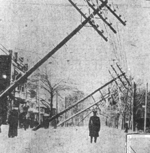
The Great Appalachian Storm of November 1950 was a large extratropical cyclone which moved through the Eastern United States, causing blizzard conditions along the western slopes of the Appalachian Mountains and significant winds and heavy rainfall east of the mountains. Hurricane-force winds, peaking at 110 miles per hour (180 km/h) in Concord, New Hampshire, and 160 mph (260 km/h) in the highlands of New England, disrupted power to 1 million customers during the event.

SS <i>Daniel J. Morrell</i> Great Lakes freighter sunk in a storm in Lake Huron

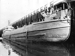
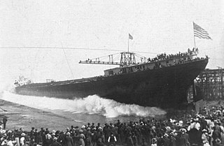
SS Daniel J. Morrell was a 603-foot (184 m) Great Lakes freighter that broke up in a strong storm on Lake Huron on 29 November 1966, taking with her 28 of her 29 crewmen. The freighter was used to carry bulk cargoes such as iron ore but was running with only ballast when the 60-year-old ship sank. When built in 1906, she was the "Queen of the Lakes", being the longest ship then in service on the Great Lakes.

<i>Mataafa</i> Storm

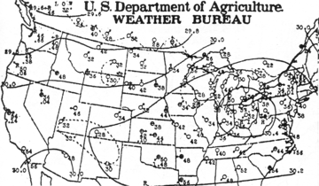
The Mataafa Storm of 1905, was a storm that occurred on the Great Lakes on November 27–28, 1905. The system moved across the Great Basin with moderate depth on November 26 and November 27, then east-northeastward across the Great Lakes on November 28. Fresh east winds were forecast for the afternoon and evening of November 27, with storm warnings in effect by the morning of November 28. Storm-force winds and heavy snows accompanied the cyclone's passage. The storm, named after the steamship Mataafa, ended up destroying or damaging about 29 vessels, killing 36 seamen, and causing shipping losses of US$ 3.567 million on Lake Superior.

SS <i>Regina</i> (1907) Steel ship that foundered in Lake Huron in a storm

The SS Regina was a cargo ship built for the Merchant Mutual Line and home ported in Montreal, Quebec. Named after Regina, Saskatchewan, Regina had a tonnage of 1,956 gross register tons (GRT) and a crew of 32.

<span class="mw-page-title-main">Braer Storm</span> Intense extratropical cyclone 1993 over the northern Atlantic Ocean

The Braer Storm was the most intense extratropical cyclone ever recorded over the northern Atlantic Ocean. Developing as a weak frontal wave on 8 January 1993, the system moved rapidly northeast. The combination of the absorption of a second low-pressure area to its southeast, a stronger than normal sea surface temperature differential along its path, and the presence of a strong jet stream aloft led to a rapid strengthening of the storm, with its central pressure falling to an estimated 914 hPa on 10 January. Its strength was well predicted by forecasters in the United Kingdom, and warnings were issued before the low initially developed.

<i>SS Andaste</i> Ship wrecked in Lake Michigan in 1929

The SS Andaste was a Monitor-class vessel, built in 1892 by the Cleveland Ship Building Company for the Lake Superior Iron Company. The vessel is best known for sinking on Lake Michigan on the night of September 9–10, 1929, with all hands; 25 men were lost. As of 2020, the wreck of Andaste has not yet been located.

SS <i>Edward Y. Townsend</i>

SS Edward Y. Townsend was a 603-foot (184 m) American Great Lakes freighter that served on the Great Lakes. She was primarily used to haul bulk cargoes such as iron ore, coal, grain and occasionally limestone. She was in service from her launching in 1906 to her sinking in 1968. She is best known for sinking on the way to the scrapper, near RMS Titanic, off the coast of Newfoundland.

<i>Plymouth</i> (schooner-barge) American Schooner barge that sank in Lake Michigan

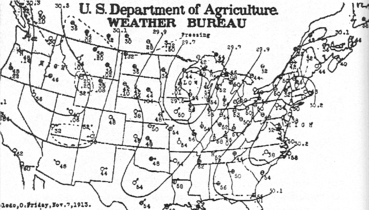
Plymouth was an American Schooner barge that sank during the Great Lakes Storm of 1913 in Lake Michigan, near St. Martins Island at the mouth of Green Bay, while she was being towed by the tug James H. Martin from Menominee, Michigan, United States to Lake Huron.

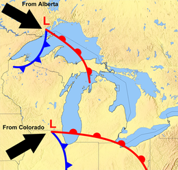
The Great Lakes Blizzard of January 1971 affected almost the entire Great Lakes region of North America, as well as the western St. Lawrence Valley and northern New England between January 25 and 28, 1971 before a second severe snowstorm hit many of the same areas between January 28 and 31, 1971. The areas that felt the fiercest effects of the dual storms, that being moderate or heavy snow, sustained high winds, and zero visibility due to blowing snow, included southern Wisconsin, most of Michigan, Southern Ontario, northeastern Ohio, northwestern Pennsylvania, most of upstate New York and Southern Quebec, while northern Wisconsin, northern Indiana, northeastern Ontario, and northern Vermont experienced blizzard conditions from the first of the storms.

References

Notes

  1. Another storm called the "Big Blow" which sank the SS Alpena was on October 15, 1880.
  2. Reprinted in Brown (2002). [41]
  3. Reprinted in Brown (2002). [33]
  4. While the boat was being lowered into the water, a breaking wave smashed it into the side of the ship. The men disappeared into the near-freezing waters below.

Citations

  1. 1 2 3 4 5 Gaylord, MI (2013). "Great Lakes Hurricane of 1913: A Meteorological Review 100 Years Later" (PDF). Winter Talk Series. National Weather Service. Retrieved November 3, 2020.
  2. 1 2 "Snowstorms". National Weather Service. Retrieved November 3, 2010.
  3. Brown 2002, p. 201.
  4. 1 2 3 Scott, Chris (November 10, 2014). "The White Hurricane: The worst storm in Great Lakes history". The Weather Network . Retrieved March 23, 2017. The Great Storm of 1913, known as the 'White Hurricane'
  5. 1 2 3 4 5 6 Heidorn, Keith C. (2001). "The Great Lakes: Storm Breeding Ground". Science of the Sky. Published online November 16, 2001, Suite101. Retrieved February 5, 2005.
  6. 1 2 Bentley, Mace; Horstmeyer, Steve (November–December 1998). "The witch of November". Weatherwise . Vol. 51, no. 6. pp. 29–35. doi:10.1080/00431672.1998.9926174.
  7. 1 2 3 Wagenmaker, Richard; Mann, Greg. "The White Hurricane Storm of 1913 A Numerical Model Retrospective" (PDF). National Weather Service. Retrieved November 2, 2021.
  8. Brown 2002, p. 246.
  9. 1 2 3 4 5 Schumacher 2013, pp. 31–32.
  10. Schumacher 2013, p. 43.
  11. 1 2 3 Brown 2002, pp. 47–48.
  12. Ratigan 1960, p. 14.
  13. Weather forecast, The Detroit News, Detroit, Michigan, November 5, 1913.
  14. "Steamer Cornell Detailed Account Of Captain Noble's Experiences In Storm On Lake Superior, November 7th, 8th & 9th, 1913". Maritime History of the Great Lakes. Retrieved June 8, 2021.
  15. Brown 2002, p. 47.
  16. Schumacher 2013, p. 40.
  17. 1 2 Front page,The WeatherPort Huron Times-Herald, Port Huron, Michigan. November 7, 1913.
  18. 1 2 Brown 2002, pp. 33–34.
  19. Brown 2002, p. 40.
  20. Brown 2002, p. 38.
  21. Brown 2002, p. 56.
  22. Front page, Port Huron Times-Herald, Port Huron, Michigan, November 8, 1913.
  23. Brown 2002, p. 59.
  24. Brown 2002, pp. 44–67.
  25. 1 2 Brown 2002, pp. 59–61.
  26. 1 2 Brown 2002, p. 80.
  27. Brown 2002, p. 12.
  28. 1 2 3 Brown 2002, pp. 99–101.
  29. Brown 2002, pp. 68–103.
  30. Brown 2002, p. 101.
  31. Brown 2002, pp. 13, 19, 68.
  32. Brown 2002, p. 127.
  33. 1 2 3 Brown 2002, p. 163.
  34. Brown 2002, pp. 208, 222.
  35. Brown 2002, p. xvii.
  36. Annual Report of the Lake Carriers' Association. 1913.
  37. Brown 2002, pp. 203, 225.
  38. Brown 2002, pp. 144–145.
  39. Brown 2002, pp. 94.
  40. Barcus 1986, p.  6.
  41. 1 2 Brown 2002, p. 162.
  42. 1 2 Brown 2002, pp. 146–147.
  43. 1 2 Brown 2002, p. 223.
  44. Minnich 1989, p. 218.
  45. Front page, Port Huron Times-Herald EXTRA edition, Port Huron, Michigan, November 15, 1913.
  46. Brown 2002, pp. 196–199.
  47. "Harbor Beach, MI (Lake Huron) Fishing Tug Searchlight Lost, Apr 1907". Daily Chronicle . Marshall, Michigan. April 25, 1907. Retrieved July 19, 2019 via Gendisasters.com.
  48. Brown 2002, p. 245.
  49. Brown 2002, pp. 205–226.
  50. Brown 2002, pp. 205–210.
  51. Brown 2002, pp. 217–219.
  52. Brown 2002, pp. 221–222.
  53. Schumacher 2013, p. 5.
  54. Brown 2002, p. 221.
  55. Brown 2002, p. 195.
  56. Brown 2002, p. 220.
  57. Brown 2002, p. 215.
  58. Schumacher 2013, p. 155.
  59. Schumacher 2013, pp. 66–68.
  60. Brown 2002, pp. 217–221.
  61. 1 2 3 4 5 6 7 8 9 10 11 12 13 14 Brown 2002, p. 203.
  62. Schumacher 2013, p. 145.
  63. 1 2 3 4 5 6 7 "Shipwrecks of the 1913 storm". National Oceanic and Atmospheric Administration . Retrieved December 1, 2019.
  64. Schaefer, Jim (November 9, 2015). "Man discovers Lake Huron shipwreck missing since 1913". Detroit Free Press . Retrieved November 9, 2015.
  65. Krueger, Andrew (June 9, 2013). "100 years after ore boat disappeared in Lake Superior storm, searchers locate wreck". Duluth News Tribune . Archived from the original on June 10, 2013.
  66. "History & Salvage of the SS Regina". Shipwrecks.com. Retrieved December 1, 2019.
  67. Vogel, Michael N.; Redding, Paul F. (1990). Maritime Buffalo. Western New York Heritage Institute. ISBN   978-1878097019. As excerpted with authors' permission by Buffalohistoryworks.com at Maritime Buffalo, Buffalo History, Lightship LV 82 on March 5, 2016. Retrieved November 4, 2021.

References

Further reading