
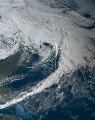
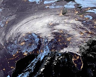
The February 2014 nor'easter was a major nor'easter that produced a damaging snow and ice storm that affected the Southern United States and East Coast of the United States, bringing with it up to a foot of snow and crippling ice across parts of the South. Thousands if not hundreds of thousands of people were left in the dark for days, possibly even up to 2 weeks without power. Delta Air Lines canceled over 2,000 flights, and it was reported by 8:00 p.m. Thursday, February 13, that as many as 6,500 flights originating in or destined for the United States had been canceled. On that day 70 percent of flights were cancelled at airports in Baltimore, Philadelphia, Washington, D.C., and Charlotte.

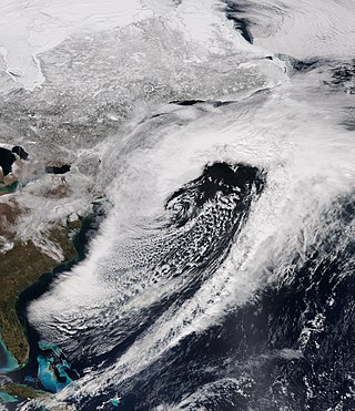
The 2013–14 North American winter was one of the most significant for the United States, due in part to the breakdown of the polar vortex in November 2013, which allowed very cold air to travel down into the United States, leading to an extended period of very cold temperatures. The pattern continued mostly uninterrupted throughout the winter and numerous significant winter storms affected the Eastern United States, with the most notable one being a powerful winter storm that dumped ice and snow in the Southeastern United States and the Northeastern United States in mid-February. Most of the cold weather abated by the end of March, though a few winter storms did affect the Western United States towards the end of the winter.

The 2010–11 North American winter was influenced by an ongoing La Niña, seeing winter storms and very cold temperatures affect a large portion of the Continental United States, even as far south as the Texas Panhandle. Notable events included a major blizzard that struck the Northeastern United States in late December with up to 2 feet (24 in) of snowfall and a significant tornado outbreak on New Year's Eve in the Southern United States. By far the most notable event was a historic blizzard that impacted areas from Oklahoma to Michigan in early February. The blizzard broke numerous snowfall records, and was one of the few winter storms to rank as a Category 5 on the Regional Snowfall Index. In addition, Oklahoma set a statewide low temperature record in February.

The 2016–17 North American winter was quite warm across North America in general, due in part to a weak La Niña that was expected to influence weather conditions across the continent. Several notable events occurred during the season, including a potent winter storm that affected the East Coast of the United States in early January, the second-largest winter tornado outbreak on record later that month, and an unusually warm February. In addition, towards the end of the season, a large cyclonic storm system that caused a large tornado outbreak, flooding, and a potent blizzard occurred in the Heartland of the country. However, the most notable event of the winter was a powerful blizzard that impacted the Northeast and New England in mid-March, towards the end of the season.

The January 4–8, 2017 North American winter storm was a major snow and ice storm that affected the Lower 48 of the United States with winter weather. Moving ashore on the West Coast on January 3, the system produced heavy snowfall in the Sierra Mountains, with nearly 4 feet of snowfall falling in the highest elevations. After impacting the Northwest and Southwest, the winter storm went on to strike the Southeast on January 5–6 with snow and ice, with snowfall accumulations up to 4 inches (10 cm). Afterwards, it began to morph into a nor'easter as it moved off the Southeast coast late on January 6, while producing blizzard conditions in the Carolinas. It then began to affect the Northeastern United States as it tracked northwards early on January 7. It produced a swath of moderate snowfall accumulations up the East Coast, with easternmost areas such as parts of Massachusetts receiving up to 1.5 feet (18 in) of snow.

The January 2017 North American ice storm was a major ice storm that impacted the Great Plains, Pacific Northwest, and American Midwest. During the storm, multiple U.S. states declared states of emergency, and icy road conditions caused traffic incidents and fatalities. It was Named Winter Storm Jupiter by the weather channel. An outbreak of 11 tornadoes also struck Texas, injuring two.

The 2017–18 North American winter saw weather patterns across North America that were very active, erratic, and protracted, especially near the end of the season, resulting in widespread snow and cold across the continent during the winter. Significant events included rare snowfall in the South, an outbreak of frigid temperatures that affected the United States during the final week of 2017 and early weeks of January, and a series of strong nor'easters that affected the Northeastern United States during the month of March. In addition, flooding also took place during the month of February in the Central United States. Finally the winter came to a conclusion with a powerful storm system that caused a tornado outbreak and blizzard in mid-April. The most intense event, however, was an extremely powerful cyclonic blizzard that impacted the Northeastern United States in the first week of 2018. Similar to the previous winter, a La Niña was expected to influence the winter weather across North America.

The January 2018 North American blizzard caused widespread severe disruption and blizzard conditions across much of the East Coasts of the United States and Canada in early January 2018. The storm dropped up to 2 feet of snow in the Mid-Atlantic states, New England, and Atlantic Canada, while areas as far south as southern Georgia and far northern Florida had brief wintry precipitation, with 0.1 inches of snow measured officially in Tallahassee, Florida. The storm originated on January 3 as an area of low pressure off the coast of the Southeast. Moving swiftly to the northeast, the storm explosively deepened while moving parallel to the Eastern Seaboard, causing significant snowfall accumulations. The storm received various unofficial names, such as Winter Storm Grayson, Blizzard of 2018 and Storm Brody. The storm was also dubbed a "historic bomb cyclone".
The March 6–8, 2018 nor'easter caused additional disruption and significant snowfall to the Northeastern United States just days after another intense nor'easter struck the Mid-Atlantic, hampering recovery efforts from that storm. Forming on March 2 and reaching the Outer Banks late on March 6, as the end phase of a long-tracked winter storm across the country, it rapidly deepened off the Mid-Atlantic coast on March 7 and brought up to 3 feet (36 in) of heavy snow, whiteout conditions, and even coastal flooding to those in the impact zone from the storm, many of whom were still without power from the previous storm less than a week prior.
The March 20–22, 2018 nor'easter, dubbed the "Four'easter" in some media outlets) brought additional significant late-season snowfall to the Northeastern United States, after three previous such nor'easters had struck the general region on March 1–3, 6–8, and 12–14, respectively. affected the Mid-Atlantic states and New England with over 18 in (46 cm) of heavy snow and whiteout conditions. It also affected areas of the Southeastern and Midwestern United States with both snowfall and severe weather. The nor'easter was also one of the heaviest spring snowstorms on record in some areas in the Mid-Atlantic, especially Philadelphia and New York City.
The January 2019 North American winter storm was a long-lived winter storm, forming as a large area of low pressure off the Pacific Northwest shoreline January 16, making its way to the Northeast by January 21. Its effects included heavy rain/high elevation snow and gusty winds in California, severe weather in the south, near-blizzard conditions in Upstate New York, an ice storm in New England and minor coastal flooding in the Mid-Atlantic.
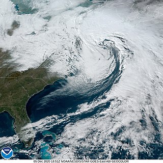
The December 5–6, 2020 nor'easter brought heavy snowfall, hurricane-force wind gusts, blizzard conditions, and coastal flooding to much of New England in the first few days of December 2020. The system originated on the Mid-Atlantic coast late on December 4. It then moved up the East Coast of the United States from December 5–6, bombing out and bringing heavy wet snow to the New England states. It brought up to 18 inches (46 cm) of snow in northern New England, with widespread totals of 6–12 inches (15–30 cm) farther south.
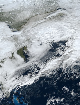
The December 15–17, 2020 nor'easter was a powerful nor'easter that hammered the Northeastern United States and produced widespread swaths of over 1 foot (12 in) of snow in much of the region from December 15–17, 2020, ending a 1,000+ day high-impact snowstorm drought in much of the Mid-Atlantic and coastal New England regions. The system developed out of a weak area of low-pressure that first developed over the Central United States producing some snowfall before moving eastward, and by December 16, a new, dominant area of low pressure began to develop along the Southeast coast. This low steadily deepened as it moved along and impacted the Mid-Atlantic coastline, prompting several winter-related advisories and warnings for much of the Northeast.
The 2020–21 New Year's North American winter storm was a major storm system that brought a wide swath of snow and ice to parts of the High Plains and Central and Northeastern United States during the New Years holiday from December 30–January 2. The system began developing early on December 30, and began spreading wintry precipitation to parts of Texas, coalescing into a low pressure system that formed near the western Gulf of Mexico. The winter storm tracked north and brought heavy snow, ice and strong winds to much of the center of the Midwest and interior parts of the Northeast and New England, causing widespread impacts and travel issues.

The January 31 – February 3, 2021 nor'easter, also known as the 2021 Groundhog Day nor'easter, was a powerful, severe, and erratic nor'easter that impacted much of the Northeastern United States and Eastern Canada from February 1–3 with heavy snowfall, blizzard conditions, strong gusty winds, storm surge, and coastal flooding. The storm first developed as an extratropical cyclone off the West Coast of the United States on January 25, with the storm sending a powerful atmospheric river into West Coast states such as California, where very heavy rainfall, snowfall, and strong wind gusts were recorded, causing several hundred thousand power outages and numerous mudslides. The system moved ashore several days later, moving into the Midwest and dropping several inches of snow across the region. On February 1, the system developed into a nor'easter off the coast of the Northeastern U.S., bringing prolific amounts of snowfall to the region. Large metropolitan areas such as Boston and New York City saw as much as 18–24 inches (46–61 cm) of snow accumulations from January 31 to February 2, making it the worst snowstorm to affect the megalopolis since the January 2016 blizzard. It was given the unofficial name Winter Storm Orlena by The Weather Channel.

The February 15–20, 2021 North American winter storm, also unofficially referred to as Winter Storm Viola, was a significant and widespread snow and ice storm across much of the United States, Northern Mexico, and Southern Canada. The system started out as a winter storm on the West Coast of the United States on February 15, later moving southeast into the Southern Plains and Deep South from February 16–17. It then moved into the Appalachian Mountains and Northeastern United States, before finally moving out to sea on February 20. The storm subsequently became a powerful low pressure system over the North Atlantic, before eventually dissipating on February 26.
The April 2021 nor'easter, also referred to as the 2021 Spring nor'easter, was a significant late-season nor'easter that impacted much of New England with heavy snowfall, gusty winds, thundersnow, and near-whiteout conditions from April 15–17, 2021. The system originated from a weak frontal system late on April 14 over North Carolina, which moved into the ocean the next day and began to strengthen. The low-pressure steadily deepened as it moved up the East Coast, and developed an eye-like feature just prior to peak intensity. It prompted a fairly large area of Winter Storm Warnings across interior sections of New England, with Winter Weather Advisories being issued closer to the coast. Over 20,000 customers lost power at the height of the storm on April 16 due to heavy wet snow, and near-whiteout conditions were reported in many areas. Several injuries, some serious, occurred as well, mostly due to traffic incidents on poorly-treated roadways during the storm. Damage estimates from the system are currently not calculated.

The 2021–22 North American winter was not as significant and record-breaking as the previous winter season. Despite this, several notable and significant events still occurred, including two separate record-breaking tornado outbreaks in mid-December, a significant winter storm in the South in mid-January, a powerful blizzard that impacted the Northeast coast at the end of January and a wide-ranging, significant winter storm that affected most of the eastern half of the country in early February. Additional significant events included a late-season winter storm in March that affected the Appalachian Mountains, and a major blizzard that affected North and South Dakota in mid-April. Addiitonally, a very late out-of-season snowstorm struck the Rocky Mountains in late May. During the season, four storms have been ranked on the Regional Snowfall Index (RSI), although none attained the “Major” category. Similar to the previous winter, a developing La Niña was expected to influence weather patterns across the continent.

The January 14–17, 2022, North American winter storm brought widespread impacts and wintry precipitation across large sections of eastern North America and parts of Canada. Forming out of a shortwave trough on January 13, it first produced a swath of snowfall extending from the High Plains to the Midwestern United States. The storm eventually pivoted east and impacted much of the Southern United States from January 15–16 before shifting north into Central Canada, the Mid-Atlantic states, and the Northeastern United States. The system, named Winter Storm Izzy by The Weather Channel, was described as a "Saskatchewan Screamer".

The January 2022 North American blizzard caused widespread and disruptive impacts to the Atlantic coast of North America from Delaware to Nova Scotia with as much as 2.5 feet (30 in) of snowfall, blizzard conditions and coastal flooding at the end of January 2022. Forming from the energy of a strong mid- to upper-level trough, the system developed into a low-pressure area off the Southeast United States on January 28. The system then quickly intensified that night as it traveled northeast parallel to the coast on January 29, bringing heavy snowfall blown by high winds to the East Coast of the continent. Further north, it also moved inland in Maine and its width meant it strongly impacted all three of Canada's Maritime provinces. In some areas, mainly the coastal regions of New Jersey, Long Island and Massachusetts, it was the first blizzard since a storm in January 2018. The storm was considered a "bomb cyclone" as it rapidly intensified and barometric pressure dropped at least 24 millibars over a 24-hour period. The storm was given names such as Blizzard of 2022 and Winter Storm Kenan.
