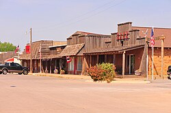
Freedom, Oklahoma

Last updated

Freedom, Oklahoma
Downtown Freedom OK.jpg
Nickname: 
Queen City of the Cimarron
OKMap-doton-Freedom.PNG
Location of Freedom within Oklahoma
Coordinates: 36°46′9″N99°6′48″W / 36.76917°N 99.11333°W / 36.76917; -99.11333 [1]
Country United States
State Oklahoma
County Woods
Incorporated 1925
Area
[2]
  Total0.39 sq mi (1.01 km2)
  Land0.39 sq mi (1.01 km2)
  Water0.00 sq mi (0.00 km2)
Elevation
[1]
1,529 ft (466 m)
Population
 (2020)
  Total174
  Density445.01/sq mi (171.96/km2)
Time zone UTC-6 (CST)
  Summer (DST) UTC-5 (CDT)
ZIP code
73842
Area code 580
FIPS code 40-27850 [1]
GNIS feature ID1093038 [1]
Website freedomokla.com

Freedom is a town in Woods County, Oklahoma, United States. [1] It lies twenty-five miles west of Alva, on the banks of the Cimarron River. [3] The population was 174 at the time of the 2020 Census. [4]

Contents

History

On September 13 and 14, 1878, the Battle of Turkey Springs was fought approximately ten miles northeast of present-day Freedom. It was the last known encounter between the United States Cavalry and American Indians in Oklahoma. [5] [6]

In the late 1800s, following the Cherokee Strip Land Run, farmers and ranchers began a small settlement in the area. This 1893 land run, combined with the building of the Buffalo and Northwestern Railroad in 1919–20, incentivized many settlers to homestead 160-acre tracts in the area. The community of Freedom-- so-named by the postal service-- was granted a post office in 1901, with Mrs. Adlah Annis serving as its first postmaster. However, it wouldn't be until 1925 that Freedom was officially incorporated, with a population of 251. [5]

The community of Freedom is known as the smallest certified city (as opposed to a town) in the state of Oklahoma. [5]

Geography

Freedom is located at 36°46′09″N99°06′48″W / 36.769179°N 99.113415°W / 36.769179; -99.113415 . [1] According to the United States Census Bureau, the town has a total area of 0.3 square miles (0.78 km2), all land.

Climate

Climate data for Freedom, Oklahoma
MonthJanFebMarAprMayJunJulAugSepOctNovDecYear
Mean daily maximum °F (°C)48.1
(8.9)
53.9
(12.2)
63.5
(17.5)
74.5
(23.6)
82.3
(27.9)
91.0
(32.8)
96.8
(36.0)
94.9
(34.9)
86.3
(30.2)
76.1
(24.5)
60.9
(16.1)
49.9
(9.9)
73.2
(22.9)
Mean daily minimum °F (°C)19.7
(−6.8)
24.7
(−4.1)
33.9
(1.1)
45.1
(7.3)
55.1
(12.8)
64.1
(17.8)
69.1
(20.6)
67.2
(19.6)
59.0
(15.0)
45.7
(7.6)
33.1
(0.6)
22.7
(−5.2)
44.9
(7.2)
Average precipitation inches (mm)0.5
(13)
0.9
(23)
1.9
(48)
2.2
(56)
3.5
(89)
3.1
(79)
2.4
(61)
3.0
(76)
2.6
(66)
1.9
(48)
1.4
(36)
0.8
(20)
24.2
(615)
Source 1: weather.com
Source 2: Weatherbase.com [7]

Demographics

Historical population
CensusPop.Note
1930 350
1940 3644.0%
1950 332−8.8%
1960 268−19.3%
1970 2929.0%
1980 33916.1%
1990 264−22.1%
2000 2712.7%
2010 2896.6%
2020 174−39.8%
U.S. Decennial Census [8]

As of the census [9] of 2000, there were 271 people, 108 households, and 77 families residing in the town. The population density was 776.7 inhabitants per square mile (299.9/km2). There were 129 housing units at an average density of 369.7 per square mile (142.7/km2). The racial makeup of the town was 95.94% White, 0.74% Asian, 2.21% from other races, and 1.11% from two or more races. Hispanic or Latino of any race were 2.58% of the population.

There were 108 households, out of which 35.2% had children under the age of 18 living with them, 58.3% were married couples living together, 10.2% had a female householder with no husband present, and 27.8% were non-families. 25.0% of all households were made up of individuals, and 12.0% had someone living alone who was 65 years of age or older. The average household size was 2.51 and the average family size was 2.97.

In the town, the population was spread out, with 29.2% under the age of 18, 6.6% from 18 to 24, 26.2% from 25 to 44, 21.4% from 45 to 64, and 16.6% who were 65 years of age or older. The median age was 38 years. For every 100 females, there were 81.9 males. For every 100 females age 18 and over, there were 86.4 males.

The median income for a household in the town was $36,250, and the median income for a family was $38,500. Males had a median income of $31,458 versus $22,500 for females. The per capita income for the town was $20,255. About 5.4% of families and 9.3% of the population were below the poverty line, including 6.8% of those under the age of eighteen and 11.1% of those 65 or over.

Economy

Cargill Salt has a solar salt processing plant 8.0 miles (12.9 km) west of Freedom. The salt is sold for livestock and industrial use. Ezra Blackmon opened a salt factory and began mechanized production, in 1935, as Blackmon Salt Company. In 1982, Cargill purchased the salt plant, expanded the evaporative ponds, and began its production in 1988. [5] [10] [11]

Freedom State Bank was a long-time presence in Freedom from its founding by David H. Powers, in 1919. When Powers died in 1934, his son, James G. (Jim) Powers, became president and kept the bank open through the Great Depression. In 1954, Nixon, James Powers' brother-in-law and long-time bank employee, became president and chief executive officer. As majority stockholder, Jim Powers continued to serve as chairman of the bank’s board of directors until his death in 1988. The bank was closed by the Federal Deposit Insurance Corporation on June 27, 2014 after regulators found that Freedom State Bank was “critically under capitalized” and had determined that its capital position was “rapidly deteriorating.” Freedom State Bank reopened as a branch of Alva State Bank & Trust following the closure., [12] [13]

Area attractions

Sign pointing to Enid, Freedom, and Alabaster Caverns along highway 412 Sign pointing to Enid, Freedom, and Alabaster Caverns along highway 412.jpg
Sign pointing to Enid, Freedom, and Alabaster Caverns along highway 412

Alabaster Caverns State Park is located 6 miles (9.7 km) south of Freedom. [5]

Freedom is host to the annual Freedom Open Rodeo and Old Cowhand Reunion, known as the "Biggest Open Rodeo in The West". The rodeo was founded in 1938, with its accompanying Chuckwagon Feed starting a year later. [14]

Related Research Articles

<span class="mw-page-title-main">Woodward County, Oklahoma</span> County in Oklahoma, United States

Woodward County is a county located in the U.S. state of Oklahoma. As of the 2020 census, the population was 20,470. Its county seat is Woodward.

<span class="mw-page-title-main">Woods County, Oklahoma</span> County in Oklahoma, United States

Woods County is a county located in the northwestern part of the U.S. state of Oklahoma. As of the 2020 census, the population was 8,624. Its county seat is Alva. The county is named after Samuel Newitt Wood, a renowned Kansas populist.

<span class="mw-page-title-main">Harper County, Oklahoma</span> County in Oklahoma, United States

Harper County is a county located in the U.S. state of Oklahoma. As of the 2020 census, the population was 3,272, making it the third-least populous county in Oklahoma. The county seat is Buffalo. It was created in 1907 from the northwestern part of Woodward County, and named for Oscar Green Harper, who was clerk of the Oklahoma Constitutional Convention.

<span class="mw-page-title-main">Harmon County, Oklahoma</span> County in Oklahoma, United States

Harmon County is a county in the southwest corner of the U.S. state of Oklahoma. As of the 2020 Census, the population was 2,488, making it the second-least populous county in Oklahoma, behind only Cimarron County. It has lost population in every census since 1930. The county seat is Hollis.

<span class="mw-page-title-main">Cimarron County, Oklahoma</span> County in Oklahoma, United States

Cimarron County is the westernmost county in the U.S. state of Oklahoma. Its county seat is Boise City. As of the 2020 census, its population was 2,296, making it the least-populous county in Oklahoma; and indeed, throughout most of its history, it has had both the smallest population and the lowest population density of any county in Oklahoma. Located in the Oklahoma Panhandle, Cimarron County contains the only community in the state (Kenton) that observes the Mountain Time Zone. Black Mesa, the highest point in the state, is in the northwest corner of the county. The Cimarron County community of Regnier has the distinction of being the driest spot in Oklahoma ranked by lowest annual average precipitation, at just 15.62 inches; at the same time, Boise City is the snowiest location in Oklahoma ranked by highest annual average snowfall, at 31.6 inches.

<span class="mw-page-title-main">Cimarron, New Mexico</span> Village in New Mexico, United States

Cimarron is a village in Colfax County, New Mexico, United States, which sits on the eastern slopes of the Sangre de Cristo Mountains. The population was 792 at the 2020 census, making it the fourth most populous municipality in Colfax County.

<span class="mw-page-title-main">Jet, Oklahoma</span> Town in Oklahoma, United States

Jet is a town in southeast Alfalfa County, Oklahoma, United States. The population was 213 at the 2010 census.

<span class="mw-page-title-main">Soper, Oklahoma</span> Town in Oklahoma, United States

Soper is a town in Choctaw County, Oklahoma, United States. The population was 261 at the 2010 census. The town was named for Pliny L. Soper, who was an attorney for the Arkansas and Choctaw Railway.

<span class="mw-page-title-main">Keyes, Oklahoma</span> Town in Oklahoma, United States

Keyes is a town in Cimarron County, Oklahoma, United States. As of the 2020 census, the town’s population was 276.

<span class="mw-page-title-main">Oilton, Oklahoma</span> City in Oklahoma, United States

Oilton is a city in Creek County, Oklahoma, United States. The population was 885 at the 2020 census, a 12.6% decline from the 1,013 recorded in 2010.

<span class="mw-page-title-main">Cedar Valley, Oklahoma</span> City in Oklahoma, United States

Cedar Valley is a city in Logan County, Oklahoma, United States. The population was 405 as of the 2020 United States census, up about 40.6% from the 288 reported at the 2010 census, and up nearly seven times the figure of 58 reported in 2000. It is part of the Oklahoma City Metropolitan Statistical Area. It is primarily a bedroom community, since more than 90 percent of the employed inhabitants commute to work in other towns. The main attraction is Cedar Valley Golf Club, which is by far the largest business in town.

<span class="mw-page-title-main">Cimarron City, Oklahoma</span> Town in Oklahoma, United States

Cimarron City is a town in Logan County, Oklahoma, United States. The population was 150 at the 2010 census, a 39.4 percent gain over the figure of 110 in 2000. It is part of the Oklahoma City Metropolitan Statistical Area. Cimarron City is a combination bedroom and retirement community.

<span class="mw-page-title-main">Coyle, Oklahoma</span> Town in Oklahoma, United States

Coyle is a town in Logan County, Oklahoma, United States. The population was 325 at the 2010 census, compared to the figure of 337 in 2000. It is part of the Oklahoma City metropolitan area. The town was named for William Coyle, an influential Guthrie business man.

<span class="mw-page-title-main">Cleo Springs, Oklahoma</span> Town in Oklahoma, United States

Cleo Springs is a town in Major County, Oklahoma, United States. The population was 287 at the time of the 2020 Census.

<span class="mw-page-title-main">Perkins, Oklahoma</span> City in Oklahoma, United States

Perkins is a city in southern Payne County, Oklahoma, United States. The population was 2,831 at the 2010 census, an increase of 24.6 percent from the figure of 2,272 in 2000. The name is derived from Walden Perkins, a congressman who helped establish the local post office. The Iowa Tribe of Oklahoma is headquartered here.

<span class="mw-page-title-main">Ripley, Oklahoma</span> Town in Oklahoma, United States

Ripley is a town in southeastern Payne County, Oklahoma, United States. The population was 423 at the 2010 census, a decline of 9.2 percent from the figure of 444 in 2000. The town was named after Edward Ripley, the 14th president of the Atchison, Topeka and Santa Fe Railway.

<span class="mw-page-title-main">Waynoka, Oklahoma</span> City in Oklahoma, United States

Waynoka is a city in Woods County, Oklahoma, United States. It is located on U.S. Highway 281 and State Highway 14, seventy miles west of Enid. The population, which peaked at 2,018 in 1950, was 708 at the time of the 2020 Census.

<span class="mw-page-title-main">Mannford, Oklahoma</span> City in Oklahoma, United States

Mannford is a city in Creek County in the northeastern part of the U.S. state of Oklahoma. The population was 3,262 at the time of the 2020 census, up from 3,076 in 2010. The city sits next to Keystone Lake and claims to be the "Striped Bass Capital of the World".

<span class="mw-page-title-main">Kenton, Oklahoma</span> Census-designated place in Oklahoma, United States

Kenton is a census-designated place (CDP) in Cimarron County, Oklahoma, United States. As of the 2020 census, the community had 31 residents.

<span class="mw-page-title-main">Alva, Oklahoma</span> City in Oklahoma, United States

Alva is a city in and the county seat of Woods County, Oklahoma, United States, along the Salt Fork Arkansas River. The population was 5,028 at the time of the 2020 Census, up from 4,945 at the 2010 census. Northwestern Oklahoma State University is located in Alva.

References

  1. 1 2 3 4 5 6 Geographic Names Information System (GNIS) details for Freedom, Oklahoma; United States Geological Survey (USGS); December 18, 1979.
  2. "ArcGIS REST Services Directory". United States Census Bureau. Retrieved September 20, 2022.
  3. Official State Map (Map) (2008 ed.). Oklahoma Department of Transportation.
  4. "Freedom (town), Oklahoma". United States Census Bureau. Retrieved April 20, 2024.
  5. 1 2 3 4 5 Decker, Kay. "Encyclopedia of Oklahoma History and Culture". Encyclopedia of Oklahoma History and Culture - Freedom. Oklahoma History Center. Retrieved April 11, 2016.
  6. "The Battle of Turkey Springs and Red Hills". Freedom Oklahoma - Queen City of the Cimarron. Archived from the original on March 4, 2016. Retrieved April 11, 2016.
  7. "Historical Weather for Freedom, Oklahoma, United States".
  8. "U.S. Decennial Census". United States Census Bureau . Retrieved September 14, 2016.
  9. "U.S. Census website". United States Census Bureau . Retrieved January 31, 2008.
  10. Oklahoma Geology Notes; Volume 30 Number 3; June 1970.
  11. Cargill Salt Production Facilities Map.
  12. Bailey, Brianna. "Freedom State Bank in Northwest Oklahoma Fails". newsok.com. The Oklahoman. Retrieved April 22, 2016.
  13. "Brett Smith appointed president, chief executive of Freedom State Ban…". Archived from the original on July 18, 2014.
  14. "Freedom Open Rodeo and Old Cowhand Reunion". Freedom Oklahoma - Queen City of the Cimarron. Retrieved April 26, 2016.