
U.S. Route 3 (US 3) is a United States Numbered Highway running 277.90 miles (447.24 km) from Cambridge, Massachusetts, through New Hampshire, to the Canada–United States border near Third Connecticut Lake, where it connects to Quebec Route 257.

Alewife station is a Massachusetts Bay Transportation Authority (MBTA) intermodal transit station in the North Cambridge neighborhood of Cambridge, Massachusetts. It is the northwest terminal of the rapid transit Red Line and a hub for several MBTA bus routes. The station is at the confluence of the Minuteman Bikeway, Alewife Linear Park, Fitchburg Cutoff Path, and Alewife Greenway off Alewife Brook Parkway adjacent to Massachusetts Route 2, with a five-story parking garage for park and ride use. The station has three bike cages. Alewife station is named after nearby Alewife Brook Parkway and Alewife Brook, themselves named after the alewife fish.

Route 2 is a 142.29-mile-long (228.99 km) major east–west state highway in Massachusetts, United States. Along with Route 9 and U.S. Route 20 to the south, these highways are the main alternatives to the Massachusetts Turnpike/I-90 toll highway. Route 2 runs the entire length of the northern tier of Massachusetts, beginning at the New York border, where it connects with New York State Route 2, and ending near Boston Common in Boston. Older alignments of Route 2 are known as Route 2A.

Fresh Pond is a reservoir and park in Cambridge, Massachusetts. Prior to the Pond's use exclusively as a reservoir, its ice had been harvested by Boston's "Ice King", Frederic Tudor, and others, for shipment to North American cities and to tropical areas around the world. Fresh Pond is bordered by Fresh Pond Parkway, Huron Avenue, Grove Street, Blanchard Road, and Concord Avenue.

The Department of Conservation and Recreation (DCR) is a state agency of the Commonwealth of Massachusetts, United States, situated in the Executive Office of Energy and Environmental Affairs. It is best known for its parks and parkways. The DCR's mission is "To protect, promote and enhance our common wealth of natural, cultural and recreational resources for the well-being of all." The agency is the largest landowner in Massachusetts.

Alewife Brook Reservation is a Massachusetts state park and urban wild located in Cambridge, Arlington, and Somerville. The park is managed by the state Department of Conservation and Recreation and was established in 1900. It is named for Alewife Brook, which was also historically known as Menotomy River, a tributary of the Mystic River.

Route 2A is a 98.5-mile-long (158.5 km) east–west state highway in Massachusetts. It exists in several sections, mainly as parts of former Route 2 that have been moved or upgraded. Route 2A runs from Greenfield in the west to Boston in the east. It formerly extended to Shelburne Falls in Buckland in the west, but as of 2007, the route terminates at Interstate 91 (I-91) in Greenfield.

Memorial Drive, colloquially referred to as Mem Drive, is a 3.9-mile (6.3 km) parkway along the north bank of the Charles River in Cambridge, Massachusetts, United States.
Alewife Brook Parkway is a short parkway in Cambridge and Somerville, Massachusetts. It is listed on the National Register of Historic Places. It begins at Fresh Pond in Cambridge, and heads north on the east bank of Alewife Brook, crossing into West Somerville and ending at the Mystic River on the Medford town line, where it becomes Mystic Valley Parkway. The entire length of Alewife Brook Parkway is designated as part of Massachusetts Route 16 (Route 16), while the southernmost sections are also designated as part of Route 2 and U.S. Route 3 (US 3). It is managed by the Department of Conservation and Recreation with the Massachusetts Department of Transportation responsible for bridge maintenance.
Mystic Valley Parkway is a parkway in Arlington, Medford, Somerville, and Winchester, Massachusetts, United States. It is listed on the National Register of Historic Places, and forms part of Route 16.

The Charles River Bike Path is a mixed-use path in the Boston, Massachusetts area. A portion of the trail is named after the cardiologist Paul Dudley White, a prominent advocate of preventive medicine. His research led him to proclaim frequently "I'd like to put everybody on bicycles." In 1955 White served as president Eisenhower's cardiologist and prescribed his famous patient bicycle therapy after his 1955 heart attack.

The Neponset Valley Parkway is a historic parkway in southern Boston and Milton, Massachusetts, United States. It is a connecting parkway in the Greater Boston area's network, providing a connection between the Blue Hills Reservation, Neponset River Reservation, and the Stony Brook Reservation. The parkway was constructed between 1898 and 1929 with design assistance from Charles Eliot and the Olmsted Brothers. It was listed on the National Register of Historic Places in 2005.
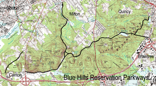
The Blue Hills Reservation Parkways are a network of historic parkways in and around the Blue Hills Reservation, a Massachusetts state park south of Boston, Massachusetts. It consists of six roadways that provide circulation within the park, and that join the park to two connecting parkways, the Blue Hills Parkway and the Furnace Brook Parkway. The roadway network was designed by Charles Eliot in the 1890s, except for Green Street, which was added to the network in the 1940s. The parkways were added to the National Register of Historic Places in 2003.

The Fells Connector Parkways are a group of historic parkways in the cities of Malden and Medford, Massachusetts, suburbs north of the city of Boston. The three parkways, The Fellsway, Fellsway West, and Fellsway East serve to provide access from the lower portion of the Mystic River Reservation to the Middlesex Fells Reservation. The latter two parkways continue northward, providing access to the interior of the Fells and providing a further connection to Lynn Fells Parkway. Significant portions of these parkways south of the Fells, which were among the first connecting parkways designed to be part of the Metropolitan Park System of Greater Boston by Charles Eliot, were listed on the National Register of Historic Places in 2003.

The Charles River Reservation Parkways are parkways that run along either side of the Charles River in eastern Massachusetts. The roads are contained within the Charles River Reservation and the Upper Charles River Reservation, and fall within a number of communities in the greater Boston metropolitan area. The Charles River parks extend from the Charles River Dam, where the Charles empties into Boston Harbor, to Riverdale Park in the West Roxbury neighborhood of Boston. Most of the roadways within the parks are listed on the National Register of Historic Places as a unit, although Storrow Drive and Memorial Drive are listed as part of the Charles River Basin Historic District.

The Middlesex Fells Reservation Parkways are the roadways within and bordering on the Middlesex Fells Reservation, a state park in the northern suburbs of Boston, Massachusetts, United States. The park includes portions of the towns of Malden, Medford, Melrose, Stoneham, and Winchester. The roads inside the park and around its perimeter have been listed on the National Register of Historic Places. Other portions of some of the roads are covered by more than one listing in the national register; see Fellsway Connector Parkways and Middlesex Fells Reservoirs Historic District.

Cambridge Highlands also known as "Area 12", is a neighborhood of Cambridge, Massachusetts bounded by the railroad tracks on the north and east, the Belmont town line on the west, and Fresh Pond on the south. In 2005 it had a population of 673 residents living in 281 households, and the average household income was $56,500.

Furnace Brook Parkway is a historic parkway in Quincy, Massachusetts. Part of the Metropolitan Park System of Greater Boston, it serves as a connector between the Blue Hills Reservation and Quincy Shore Reservation at Quincy Bay. First conceived in the late nineteenth century, the state parkway is owned and maintained by the Massachusetts Department of Conservation and Recreation (DCR) and travels through land formerly owned by the families of John Adams and John Quincy Adams, passing several historic sites. It ends in the Merrymount neighborhood, where Quincy was first settled by Europeans in 1625 by Captain Richard Wollaston. The road was started in 1904, completed in 1916 and added to the National Register of Historic Places (NRHP) in 2004.

The Watertown Branch Railroad was a branch loop of the Fitchburg Railroad that was meant to serve the town of Watertown and the City of Waltham, Middlesex County, Massachusetts, as an independent short line railroad; it also serviced the Watertown Arsenal. The line has been formally abandoned and portions have been converted into a rail trail, the Watertown-Cambridge Greenway. A section from School Street to Arlington Street in Watertown was completed first. A small portion in Waltham has been converted into a park called Chemistry Station Park after the railroad station once located there. Construction of an extension to Fresh Pond Reservation in Cambridge began in the summer of 2018 and was completed in June 2022.
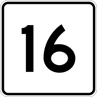
Route 16 is a 59.8646-mile-long (96.3427 km) east–west state highway in Massachusetts. It begins in the west at an intersection with Route 12 and Route 193 in Webster, just north of the Connecticut state border. It runs in a generally southwest-northeast routing through a number of Boston's suburbs and runs to the west and then north of the city before ending in Revere at an intersection with Route 1A and Route 60.


