Quincy is a city in Norfolk County, Massachusetts, United States. It is the largest city in the county and a part of Greater Boston, being Boston's immediate southern suburbs. Its population in 2020 was 101,636, making it the seventh-largest city in the state. Known as the "City of Presidents", Quincy is the birthplace of two U.S. presidents—John Adams and his son John Quincy Adams—as well as John Hancock, the first signer of the Declaration of Independence and the first and third governor of Massachusetts.
The Bronx River Parkway is a 19.12-mile (30.77 km) limited-access parkway in downstate New York in the United States. It is named for the nearby Bronx River, which it parallels. The southern terminus of the parkway is at Story Avenue near the Bruckner Expressway in the Bronx neighborhood of Soundview. The northern terminus is at Kensico Circle in North Castle, Westchester County, where the parkway connects to the Taconic State Parkway and via a short connector, New York State Route 22 (NY 22). Within the Bronx, the parkway is maintained by the New York State Department of Transportation and is designated New York State Route 907H (NY 907H), an unsigned reference route. In Westchester County, the parkway is maintained by the Westchester County Department of Public Works and is designated unsigned County Route 9987 (CR 9987).

The Department of Conservation and Recreation (DCR) is a state agency of the Commonwealth of Massachusetts, United States, situated in the Executive Office of Energy and Environmental Affairs. It is best known for its parks and parkways. The DCR's mission is "To protect, promote and enhance our common wealth of natural, cultural and recreational resources for the well-being of all." The agency is the largest landowner in Massachusetts.

Memorial Drive, colloquially referred to as Mem Drive, is a 3.9-mile (6.3 km) parkway along the north bank of the Charles River in Cambridge, Massachusetts, United States.

Morton Street is a street in southern Boston, Massachusetts, United States. It extends from the southeastern end of the Arborway in Jamaica Plain to Washington Street in the Lower Mills Village of Dorchester. Most of the road is a connecting parkway, signed as part of Massachusetts Route 203, that provides access to Boston's Emerald Necklace of parks. That portion of the road was listed on the National Register of Historic Places in 2005.

The Neponset Valley Parkway is a historic parkway in southern Boston and Milton, Massachusetts, United States. It is a connecting parkway in the Greater Boston area's network, providing a connection between the Blue Hills Reservation, Neponset River Reservation, and the Stony Brook Reservation. The parkway was constructed between 1898 and 1929 with design assistance from Charles Eliot and the Olmsted Brothers. It was listed on the National Register of Historic Places in 2005.

The Stony Brook Reservation Parkways are a group of historic parkways in Boston and Dedham, Massachusetts. They provide access to and within the Stony Brook Reservation, a Massachusetts state park. The roadways and the park are administered by the Massachusetts Department of Conservation and Recreation, a successor to the Metropolitan District Commission, which oversaw their construction. The roads consist of the Dedham, Enneking, and Turtle Pond Parkways and West Boundary Road. Two roads within the park, Smithfield Road and Reservation Road, are listed as non-contributing properties. The park roads were built between 1894 and 1956, and were listed on the National Register of Historic Places in 2006.

The Truman Parkway is a historic parkway in Milton and southern Boston, Massachusetts. It runs along the southern boundary of a portion of the Neponset River Reservation and serves as a connection between the Neponset Valley Parkway and the Blue Hills Parkway. The parkway was built in 1931 and added to the National Register of Historic Places in 2005.

The Veterans of Foreign Wars Parkway is a historic parkway in Boston, Massachusetts. The southern terminus of the parkway is at Washington Street at the Dedham-West Roxbury border, from where it travels north and then east, ending at a junction with Centre Street, near the Arnold Arboretum. The highway is almost entirely contained within the West Roxbury neighborhood, although it passes through part of the Chestnut Hill neighborhood near its junction with the West Roxbury Parkway. Most of its length, from Spring Street in West Roxbury to its eastern end, is administered by the Massachusetts Department of Conservation and Recreation (DCR), a successor to the Metropolitan District Commission (MDC) which oversaw the road's construction. The parkway was built in stages between 1930 and 1942, and was designed to provide a parkway connection from the Upper Charles River Reservation to other MDC parks via the West Roxbury Parkway. The DCR portion of the road was listed on the National Register of Historic Places in 2005. The road formerly carried the designation for U.S. Route 1.

Winthrop Parkway is a historic parkway in Revere, Massachusetts. The parkway, built between 1909 and 1919 and now designated as part of Route 145, runs for about 0.75 miles (1.21 km), from Eliot Circle southeast to the Revere-Winthrop line. Acquisitions for its construction represent the last public purchase of oceanfront lands in Revere. It was listed on the National Register of Historic Places in 2004.

Fresh Pond Parkway is a historic park and parkway on the western end of Cambridge, Massachusetts. It is part of the Metropolitan Park System of Greater Boston. The parkway was built in 1899 and added to the National Register of Historic Places in 2005.
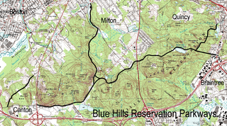
The Blue Hills Reservation Parkways are a network of historic parkways in and around the Blue Hills Reservation, a Massachusetts state park south of Boston, Massachusetts. It consists of six roadways that provide circulation within the park, and that join the park to two connecting parkways, the Blue Hills Parkway and the Furnace Brook Parkway. The roadway network was designed by Charles Eliot in the 1890s, except for Green Street, which was added to the network in the 1940s. The parkways were added to the National Register of Historic Places in 2003.

Hull Shore Drive and Nantasket Avenue are a historic coastal parkway in Hull, Massachusetts. Nantasket Avenue, designated as part of Route 228, is the main road through the town of Hull. Hull Shore Drive is a short segment of the road, near the Nantasket Beach Reservation at the southern end of the Hull peninsula. A 1.25-mile (2.01 km) section of the roads was added to the National Register of Historic Places in 2004.

Nahant Beach Boulevard, also Nahant Causeway and Nahant Road, is a historic road on the isthmus connecting Nahant, Massachusetts to the mainland at Lynn, Massachusetts, United States. The road runs from the Lynn Rotary, its junction with Lynn Shore Drive and the Lynnway, about 1.5 miles (2.4 km) to Wilson Road in Nahant. It passes through Nahant Beach Reservation, a state park offering beach access on the isthmus. The road offers expansive views of the area coastlines and Boston Harbor. Both the park and the roadway are administered by the Massachusetts Department of Conservation and Recreation.

The Fells Connector Parkways are a group of historic parkways in the cities of Malden and Medford, Massachusetts, suburbs north of the city of Boston. The three parkways, The Fellsway, Fellsway West, and Fellsway East serve to provide access from the lower portion of the Mystic River Reservation to the Middlesex Fells Reservation. The latter two parkways continue northward, providing access to the interior of the Fells and providing a further connection to Lynn Fells Parkway. Significant portions of these parkways south of the Fells, which were among the first connecting parkways designed to be part of the Metropolitan Park System of Greater Boston by Charles Eliot, were listed on the National Register of Historic Places in 2003.

The Middlesex Fells Reservation Parkways are the roadways within and bordering on the Middlesex Fells Reservation, a state park in the northern suburbs of Boston, Massachusetts, United States. The park includes portions of the towns of Malden, Medford, Melrose, Stoneham, and Winchester. The roads inside the park and around its perimeter have been listed on the National Register of Historic Places. Other portions of some of the roads are covered by more than one listing in the national register; see Fellsway Connector Parkways and Middlesex Fells Reservoirs Historic District.

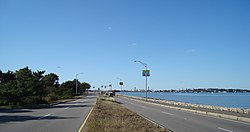
Furnace Brook Parkway is a historic parkway in Quincy, Massachusetts. Part of the Metropolitan Park System of Greater Boston, it serves as a connector between the Blue Hills Reservation and Quincy Shore Reservation at Quincy Bay. First conceived in the late nineteenth century, the state parkway is owned and maintained by the Massachusetts Department of Conservation and Recreation (DCR) and travels through land formerly owned by the families of John Adams and John Quincy Adams, passing several historic sites. It ends in the Merrymount neighborhood, where Quincy was first settled by Europeans in 1625 by Captain Richard Wollaston. The road was started in 1904, completed in 1916 and added to the National Register of Historic Places (NRHP) in 2004.

Blue Hills Parkway is a historic parkway that runs in a straight line from a crossing of the Neponset River, at the south border of Boston to the north edge of the Blue Hills Reservation in Milton, Massachusetts. It was built in 1893 to a design by the noted landscape architect, Charles Eliot, who is perhaps best known for the esplanades along the Charles River. The parkway is a connecting road between the Blue Hills Reservation and the Neponset River Reservation, and was listed on the National Register of Historic Places in 2003.

Hammond Pond Parkway is a historic parkway in Chestnut Hill, Massachusetts. The road, built in 1932, extends 2 miles (3.2 km) from Hobart Road in Newton to Horace James Circle in Brookline, where it joins the West Roxbury Parkway. It was designed by Charles Eliot and the Olmsted Brothers to provide a parkway setting that provided access from Brookline, Newton, and the western portions of Boston to the southern parks of the Emerald Necklace. The parkway was listed on the National Register of Historic Places in 2004.

William J. Day Boulevard, or Day Boulevard, is a coastal parkway in Boston, Massachusetts. Beginning at Morrissey Boulevard and Kosciuszko Circle at the northern extent of the Dorchester section of the city, it travels in a gently curving northeasterly direction 2.6 miles (4.2 km) through South Boston along beaches around the west and north shore of Dorchester Bay. It was named for William J. Day.