Quincy is a coastal U.S. city in Norfolk County, Massachusetts, United States. It is the largest city in the county and a part of Metropolitan Boston as one of Boston's immediate southern suburbs. Its population in 2020 was 101,636, making it the seventh-largest city in the state. Known as the "City of Presidents", Quincy is the birthplace of two U.S. presidents—John Adams and his son John Quincy Adams—as well as John Hancock and the first and third Governor of Massachusetts.

Charlestown is the oldest neighborhood in Boston, Massachusetts, in the United States. Originally called Mishawum by the Massachusett tribe, it is located on a peninsula north of the Charles River, across from downtown Boston, and also adjoins the Mystic River and Boston Harbor waterways. Charlestown was laid out in 1629 by engineer Thomas Graves, one of its earliest settlers, during the reign of Charles I of England. It was originally a separate town and the first capital of the Massachusetts Bay Colony.

Dorchester is a Boston neighborhood comprising more than 6 square miles (16 km2) in the City of Boston, Massachusetts, United States. Originally, Dorchester was a separate town, founded by Puritans who emigrated in 1630 from Dorchester, Dorset, England, to the Massachusetts Bay Colony. This dissolved municipality, Boston's largest neighborhood by far, is often divided by city planners in order to create two planning areas roughly equivalent in size and population to other Boston neighborhoods.
The Boston Harbor Islands National Recreation Area is a national recreation area situated among the islands of Boston Harbor of Boston, Massachusetts. The area is made up of a collection of islands, together with a former island and a peninsula, many of which are open for public recreation and some of which are very small and best suited for wildlife. The area is run by the Boston Harbor Islands Partnership. It includes the Boston Harbor Islands State Park, managed by the Commonwealth of Massachusetts. Twenty-one of the 34 islands in the area are also included in the Boston Harbor Islands Archeological District.

The MBTA boat or MBTA ferry system is a public boat service providing water transportation in Boston Harbor. It is operated by Boston Harbor Cruises (BHC) under contract to the Massachusetts Bay Transportation Authority (MBTA). In 2021, the system had a ridership of 394,200, or about 3,000 per weekday as of the second quarter of 2022. The system consists of three routes that terminate in downtown Boston. F1 service runs from Rowes Wharf to Hewitt's Cove in Hingham. F2H service runs from Long Wharf to Hewitt's Cove, with some trips stopping at Logan Airport, Pemberton Point in Hull, and/or some of the Boston Harbor Islands. F4 service runs in the inner harbor between Long Wharf and the Charlestown Navy Yard. A seasonal pilot service also operates between Long Wharf and East Boston. Two additional seasonal routes, not funded by the MBTA but included on some MBTA documents, run from Boston to Salem and Winthrop.

North Quincy station is an MBTA subway Red Line station in Quincy, Massachusetts. It is located in North Quincy, off Hancock Street. A major park-and-ride stop, it has over 1200 parking spaces for commuters. It also serves as a minor bus terminal, with five MBTA bus routes stopping at the south end of the station. The station is fully accessible.

Houghs Neck is a one-square-mile (2.6 km2) peninsula in Quincy, Massachusetts. It is surrounded by Quincy Bay, Hingham Bay and Rock Island Cove. It is lined by Perry Beach, which runs along Manet Avenue; Nut Island, which is just beyond Great Hill at the very end of the peninsula; and Edgewater Drive.

Moon Island is an island in Quincy Bay, in the middle of Boston Harbor, Massachusetts. It is the location of the Boston Fire Department Training Academy, and Boston Police Department shooting range. All of the land on the island is owned by the City of Boston but the island is under the jurisdiction of Quincy, Massachusetts. It is also part of the Boston Harbor Islands National Recreation Area.
North Quincy is a neighborhood of Quincy, Massachusetts. It is separated from the city of Boston by the Neponset River, and borders the Quincy neighborhoods of Squantum, Montclair and Wollaston. It contains the smaller neighborhoods of Atlantic and Norfolk Downs, as well as much of Wollaston Beach.

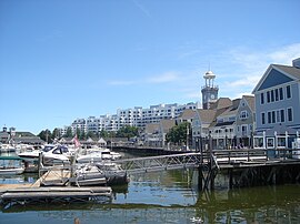
Quincy Point is a neighborhood of Quincy, Massachusetts. "The Point" is generally defined as the land east of Quincy Center, the downtown district. Quincy Point is bordered on the west by Elm Street, on the east by Weymouth Fore River and the Braintree city line, on the north by Town River and on the south by Quincy Avenue. The area altitude averages about 30 feet (9.1 m) above sea level. The population of this neighborhood in 2000 was 11,414.

Wollaston Beach is the largest public beach in the Boston harbor. The beach is located parallel to Quincy Shore Drive in North Quincy, Massachusetts, which was constructed to provide access to the bay beach for Greater Boston. Wollaston beach expands Quincy Bay forming part of Boston Harbor. The northern end of the beach is the Native American historical site, Moswetuset Hummock which is where the original Moswetuset Sac'hem (Chief) had a tribal council.

Naval Air Station Squantum was an active naval aviation facility during 1917 and from 1923 until 1953. The original civilian airfield that preceded it, the Harvard Aviation Field, dates back to 1910. The base was sited on Squantum Point in the city of Quincy, Massachusetts. It also abutted Dorchester Bay, Quincy Bay, and the Neponset River.

Boston Harborwalk is a public walkway that follows the edge of piers, wharves, beaches, and shoreline around Boston Harbor. When fully completed it will extend a distance of 47 miles (76 km) from East Boston to the Neponset River.

Quincy Bay is the largest of the three small bays of southern Boston Harbor, part of Massachusetts Bay and forming much of the shoreline of the city of Quincy, Massachusetts. Locally in the Wollaston neighborhood of Quincy it is known as Wollaston Bay. The bay is home to Moon Island, Long Island, and Hangman Island.
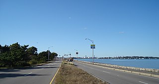
Quincy Shore Drive is a historic parkway in Quincy, Massachusetts. The road is one of a series of parkways built by predecessors of the Massachusetts Department of Conservation and Recreation, to provide access to parks and beaches in the Greater Boston area. Its development was proposed in 1893 by Charles Eliot, who promoted the development of many of the area's parks and parkways. Planning began in 1897, with land acquisition following around 1900. Construction of the 4-mile (6.4 km) road was begun in 1903 and completed in 1907.
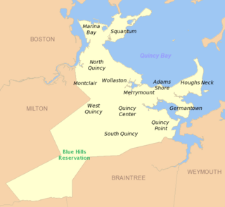
Adams Shore is a neighborhood of Quincy, Massachusetts. It is located on the shore of Quincy Bay at the entrance to the Hough's Neck peninsula. It is bordered on the north by Quincy Bay, on the east by the Hough's Neck neighborhood, on the south by Town River Bay and on the west by the Merrymount neighborhood. According to the U.S. Census Bureau, in 2000 the population of Adams Shore was just over 1,500.

Squantum is a neighborhood of Quincy, Massachusetts, connected to the mainland by a causeway that crosses over a wetland area of the bay. Often thought of as a peninsula, Squantum proper is technically a barrier island as it is surrounded on all four sides by water and is only connected to the mainland and Moon Island via causeways. Located in the northernmost portion of the city, Squantum is bordered on the north by Dorchester Bay and Boston Harbor, on the east by Moon Island and Quincy Bay, on the south by Quincy Bay and North Quincy, and on the west by the Marina Bay development. The population of the neighborhood in 2000 according to the United States Census Bureau was 2,626. Squantum has scenic, waterfront views of Boston Harbor and the Boston skyline and has many of Quincy’s most expensive homes. Squantum residents are the wealthiest of any neighborhood in Quincy, according to the 2010 United States Census Bureau, and the home ownership rate is approximately 92%. The neighborhood is further characterized by its tree-lined streets, its "island getaway" feel, close-knit community, and its annual Squantum Fourth of July Parade. As described in a 2020 book, "One road leads in and out of a square mile of land that is a playground for children and a haven for adults." Squantum also has one of the largest Irish populations, on a per capita basis, of any neighborhood in the United States

Dorchester Bay is the smallest of the three smaller bays of southern Boston Harbor, part of Massachusetts Bay and forming the south shoreline of the South Boston neighborhood and northeast shoreline of the Dorchester neighborhood of Boston, as well as the north shore of the city of Quincy in Massachusetts.
Dennison Airport was an airfield operational in the mid-20th century in Quincy, Massachusetts, United States.
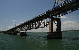
The Long Island Bridge, sometimes referred to as the Long Island Viaduct, was a bridge in Boston, Massachusetts, that connected Long Island to Moon Island. Both islands are located in Boston Harbor and are connected to the mainland via a causeway from Moon Island to Squantum, a neighborhood of Quincy, Massachusetts.