
Russell County is a county located in the Commonwealth of Virginia. As of the 2020 census, the population was 25,781. Its county seat is Lebanon.

Tazewell County is a county in the U.S. state of Illinois. According to the 2020 census, it had a population of 131,343. Its county seat and largest city is Pekin. It is pronounced with a short "a", to rhyme with "razz" rather than "raze."

Tazewell is a town in and the county seat of Claiborne County, Tennessee, United States. The population was 2,165 at the 2000 census, 2,218 at the 2010 census, and 2,348 at the 2020 census. The town is named for Tazewell, Virginia, which itself was named for Henry Tazewell (1753–1799), a U.S. senator from Virginia.

Tazewell is a town in Tazewell County, Virginia, United States. The population was 4,627 at the 2010 census. It is part of the Bluefield, WV-VA micropolitan area, which has a population of 107,578. It is the county seat of Tazewell County.

Tazewell County is a county located in the southwestern portion of the U.S. state of Virginia. As of the 2020 census, the population was 40,429. Its county seat is Tazewell.
Littleton Waller Tazewell was a Virginia lawyer, plantation owner, and politician who served as U.S. Representative, U.S. Senator and the 26th Governor of Virginia, as well as a member of the Virginia House of Delegates.

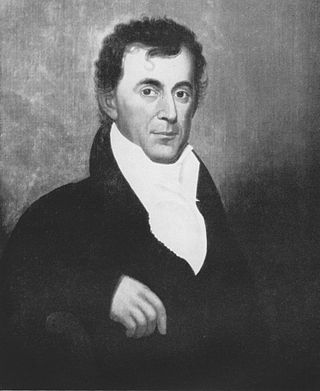
Henry Tazewell was an American politician who was instrumental in the early government of Virginia, and a US senator from Virginia. He was a slave owner, and served as President pro tempore of the United States Senate in 1795.
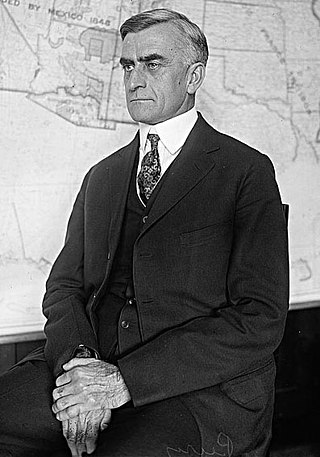
George Campbell Peery was an American Democratic politician, and was the 52nd governor of Virginia from 1934 to 1938. He became the second governor to be selected, at least partially, by the soon to be very powerful Byrd Organization, led by Senator Harry F. Byrd, Sr.

Tazewell High School (THS) is a public secondary school in Tazewell, Virginia, United States. It is part of Tazewell County Public Schools and is located on 627 Fincastle Road. As of the 2007-2008 school year, enrollment is around 500 students.

State Route 67 is a primary state highway in the southwest part of the U.S. state of Virginia. It runs from SR 80 near Honaker east to U.S. Route 460 at Raven, east concurrently with US 460 and US 460 Business into downtown Richlands, and north to SR 616 at Jewell Ridge on the Tazewell–Buchanan county line.

State Route 16 is a primary state highway in the southwest part of the U.S. state of Virginia. It runs from the North Carolina border at North Carolina Highway 16 north to the West Virginia border at West Virginia Route 16, passing through the towns of Troutdale, Marion, and Tazewell. Highway 16 is part of a three-state route 16 that connects the Charlotte region with northwestern West Virginia.

State Route 91 is a primary state highway in the U.S. state of Virginia. The state highway runs 55.12 miles (88.71 km) from the Tennessee state line near Damascus, where the highway continues as Tennessee State Route 91, north to U.S. Route 19 Business and US 460 Business at Frog Level. SR 91 connects Damascus in southeastern Washington County with the northeastern county town Glade Spring, where the highway has junctions with US 11 and Interstate 81 (I-81). The state highway also indirectly connects Saltville in northwestern Smyth County and Tazewell, the county seat of Tazewell County. SR 91 is the only primary state highway in Virginia with an unpaved section; this gravel section is in southern Tazewell County.

U.S. Route 19 (US 19) is a part of the United States Numbered Highway System that runs from Memphis, Florida, to Erie, Pennsylvania. In Virginia, the highway runs 88.89 miles (143.05 km) between two pairs of twin cities: Bristol, Tennessee, and Bristol, Virginia, at the Virginia–Tennessee state line, and Bluefield, Virginia, and Bluefield, West Virginia, at the Virginia–West Virginia state line. Between its endpoints, US 19 has lengthy concurrencies with US 11, US 58 Alternate, and US 460 during its course connecting Abingdon, Lebanon, and Tazewell within Washington, Russell, and Tazewell counties in Southwest Virginia.

State Route 61 is a primary state highway in the U.S. state of Virginia. The state highway runs 48.16 miles (77.51 km) from SR 16 in Tazewell east to U.S. Route 460 in Narrows. SR 61 passes through several narrow creek valleys as it parallels the West Virginia state line through Tazewell, Bland, and Giles counties. The only sizeable community between the highway's endpoints is Rocky Gap, where the highway meets US 52 and Interstate 77 (I-77).

Henry Bowen was a Virginia lawyer, soldier and politician from Tazewell County, Virginia. After raising a unit which became the 22nd Virginia Cavalry, he fought for the Confederate States of America during the American Civil War, after which Bowen served in the Virginia House of Delegates, as well as the U.S. House of Representatives, first as a Readjuster, then as a Republican.

Rees Tate Bowen was a nineteenth-century American congressman, magistrate and judge from Virginia. He was the father of Henry Bowen.
The Bluefield Micropolitan Statistical Area, as defined by the United States Census Bureau, is an area consisting of two counties – one in West Virginia and one in Virginia – anchored by the town of Bluefield, West Virginia.
There are two communities in the U.S. state of Virginia named Frog Level:
Frog Level may refer to the following places or structures in the United States:
This is intended to be a complete list of the properties and districts on the National Register of Historic Places in Tazewell County, Virginia, United States. The locations of National Register properties and districts for which the latitude and longitude coordinates are included below, may be seen in a Google map.


