A ZIP Code is a postal code used by the United States Postal Service (USPS) in a system it introduced in 1963. The term ZIP is an acronym for Zone Improvement Plan; it was chosen to suggest that the mail travels more efficiently and quickly when senders use the code in the postal address. The basic format consists of five digits. An extended ZIP+4 code was introduced in 1983 which includes the five digits of the ZIP Code, followed by a hyphen and four additional digits that reference a more specific location.

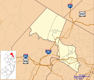
Oak Ridge is an unincorporated community located along the border of West Milford Township in Passaic County and Jefferson Township in Morris County, New Jersey, United States. The area is served as United States Postal Service ZIP Code 07438.

Jewell is an unincorporated community in northern Richland Township, Defiance County, Ohio, United States. Although it is unincorporated, it has a post office, with the ZIP code of 43530. It is located at the intersection of County Roads 55 and 185, a short distance southeast of U.S. Route 24.

Horton is an unincorporated community in Marshall County, Alabama, United States. Its ZIP code is 35980. As of the 2000 census, the population was approximately 4,450. The median household income was $27,536, and the per capita income was $13,342. The median value of a single-family home was $72,200.

Jewell is an unincorporated community in Warren County, Georgia, United States. It lies along Georgia Piedmont Scenic Byway State Route 16 to the southwest of the city of Warrenton, the county seat of Warren County. Jewell's elevation is 420 feet (128 m). Although it is unincorporated, it has a post office, with the ZIP code of 31045.

Ridge is an unincorporated community in Robertson County, Texas, United States. It lies at an elevation of 358 feet (109 m), and it is located at 31°08′44″N96°19′19″W. Ridge is located along U.S. Route 79 and a Missouri Pacific Railroad line.

Greenwood is an unincorporated community in Albemarle County, Virginia, United States. It is home to the Greenwood Country Store and the Greenwood Community Center, which has the area's only Roller Skating rink. Greenwood has a post office with ZIP code 22943 The Greenwood Tunnel, built by Claudius Crozet for the Blue Ridge Railroad and used by the Chesapeake and Ohio Railway until its abandonment during World War II, is near Greenwood by the Buckingham Branch Railroad tracks.

Taylor Ridge is an unincorporated community in Rock Island County, Illinois, United States. Taylor Ridge is located at the junction of Illinois Route 94 and Illinois Route 192, 4 miles (6.4 km) north of Reynolds. Taylor Ridge has a post office with ZIP code 61284.

Cool Ridge is an unincorporated community in Raleigh County, West Virginia, United States. Cool Ridge is located on U.S. Route 19 3.5 miles (5.6 km) south of Shady Spring. Cool Ridge has a post office with ZIP code 25825.

Arcola is an unincorporated community in Upper Providence Township, Montgomery County, Pennsylvania, United States. Arcola is located on Perkiomen Creek 6.5 miles (10.5 km) west-northwest of Norristown. Arcola has a post office with ZIP code 19420, which opened on June 4, 1889.

West Ridge is an unincorporated community in Mississippi County, Arkansas, United States. West Ridge is located on Arkansas Highway 140, 3.5 miles (5.6 km) south-southwest of Etowah. West Ridge has a post office with ZIP code 72391.

Cord is an unincorporated community in Independence County, Arkansas, United States. Cord is located at the junction of Arkansas highways 37 and 122, 9.5 miles (15.3 km) northeast of Newark. Cord has a post office with ZIP code 72524.

Charlotte is an unincorporated community in Independence County, Arkansas, United States. Charlotte is located on Highway 25S, 12 miles (19 km) east-northeast of Batesville. Charlotte has a post office with ZIP code 72522.

Heiskell is an unincorporated community in Knox and Anderson counties, Tennessee, United States. It is the location of a post office, assigned ZIP code 37754.

Penland is an unincorporated community in Mitchell County, North Carolina, United States. Penland is 2.9 miles (4.7 km) west-northwest of Spruce Pine. Approximately 200 year-round residents live in the community, the center of which is the Penland Road bridge crossing the North Toe River and CSX railroad line.

Jonas Ridge is an unincorporated community in Burke County, North Carolina, United States. Jonas Ridge is located on North Carolina Highway 181 in northwestern Burke County, 3.9 miles (6.3 km) south-southeast of Crossnore. Jonas Ridge has a post office with ZIP code 28641.

McGrady is an unincorporated community in Wilkes County, North Carolina, United States. McGrady is located along North Carolina Highway 18, 14 miles (23 km) north-northwest of Wilkesboro. McGrady has a post office with ZIP code 28649. McGrady is located at the base of the Blue Ridge Mountains; the Blue Ridge dominate the community's northern horizon. McGrady consists of numerous valleys with creeks and streams, lower mountain ridges, farms, and forests. The largest stream in the community is Mulberry Creek, which flows south to the Yadkin River, Wilkes County's largest river.

Oak Ridge is an unincorporated community in Armstrong County, Pennsylvania, United States. The community is located on the south bank of Redbank Creek between Hawthorn and New Bethlehem. Oak Ridge has a post office with ZIP code 16245.
Rural Ridge is an unincorporated community in Allegheny County, Pennsylvania, United States. The area known as Rural Ridge is located in the municipality of Indiana Township, in suburban Pittsburgh, and in the Fox Chapel Area School District.

Chestnut Ridge is an unincorporated community in Fayette County, Pennsylvania, United States. The community is 7.3 miles (11.7 km) northwest of Uniontown. Chestnut Ridge has a post office with ZIP code 15422, which opened on August 22, 1912.


