GNSS augmentation

Last updated

Augmentation of a global navigation satellite system (GNSS) is a method of improving the navigation system's attributes, such as precision, reliability, and availability, through the integration of external information into the calculation process. There are many such systems in place, and they are generally named or described based on how the GNSS sensor receives the external information. Some systems transmit additional information about sources of error (such as clock drift, ephemeris, or ionospheric delay), others provide direct measurements of how much the signal was off in the past, while a third group provides additional vehicle information to be integrated in the calculation process.

Contents

Satellite-based augmentation system

Service areas of satellite-based augmentation systems (SBAS) SBAS Service Areas.png
Service areas of satellite-based augmentation systems (SBAS)
A list of GNSS and SBAS satellites received by a phone Satellite signals on a 2018 Android phone 03.png
A list of GNSS and SBAS satellites received by a phone

Satellite-based augmentation systems (SBAS) support wide-area or regional augmentation through the use of additional satellite-broadcast messages. Using measurements from the ground stations, correction messages are created and sent to one or more satellites for broadcast to end users as differential signal. SBAS is sometimes synonymous with WADGPS, wide-area differential GPS. [1]

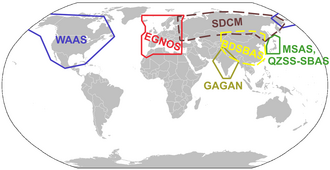
The SBAS that have been implemented or proposed include:

Ground-based augmentation system

Ground-based augmentation system (GBAS) provides Differential GPS (DGPS) corrections and integrity verification near an airport, providing approaches e.g. for runways that do not have ILSs. Reference receivers in surveyed positions measure GPS deviations and calculate corrections emitted at 2 Hz through VHF data broadcast (VDB) within 23 nmi (43 km). One GBAS supports up to 48 approaches and covers many runway ends with more installation flexibility than an ILS with localizer and glideslope antennas at each end. A GBAS can provide multiple approaches to reduce wake turbulence and improve resilience, maintaining availability and operations continuity. [8]

In December 2008, the Port Authority of New York and New Jersey invested $2.5 million to install a GBAS at Newark Airport (EWR) with Continental (now United) equipping 15 aircraft for $1.1 million while the FAA committed $2.5 million to assess the technology. Honeywell’s SLS-4000 GBAS design was approved by the FAA in September 2009 and is still the only one. It offers Cat. 1 instrument landings with a 200 ft (61 m) decision height and can be upgraded to a 100 ft (30 m) Cat. 2 with real-time monitoring of ionospheric conditions through SBAS, while the more precise Cat. 3 SLS-5000 is waiting for compatible airliners. The first installations were approved in EWR in 2012 and Houston / IAH in 2013. The Port Authority recommends a GBAS for New York JFK and LaGuardia (LGA) to alleviate congestion. Newark and Houston GBAS were upgraded to Cat. 2, Seattle-Tacoma, San Francisco SFO, JFK and LGA are expected next. [8]

Among the 20 Honeywell GBAS installations worldwide, the other U.S. installations are: Honeywell's test facility in Johnson County, Kansas; the FAA Technical Center at Atlantic City International Airport, New Jersey; Boeing's test facility in Grant County, Washington; the B787 plant in Charleston International, South Carolina; and Anoka County–Blaine Airport near Minneapolis. Airports equipped in Europe are Bremen, Frankfurt, Málaga and Zurich. in Asia-Pacific, airport with installations are Chennai, Kuala Lumpur, Melbourne, Seoul-Gimpo, Shanghai-Pudong and Sydney. Other locations are St. Helena in the South Atlantic, Punta Cana in the Dominican Republic and Rio de Janeiro–Galeão. There are around 100 Cat. 1 GBAS landing systems (GLS) installations in Russia with Russian-specific technology. [8]

In the US, GBAS was previously known as the Local-area augmentation system while a SBAS with a ground references network providing GPS corrections is called WAAS.

In the US, there were more WAAS LPV approaches reaching 200 ft (61 m) than Cat. 1 ILS approaches by March 2018. 1 GBAS costs $3–4 million; and $700,000 more for Cat. 2. [8]

By Spring 2018, Boeing delivered 3,500 GLS-capable airliners, with 5,000 on order: GLS Cat. 2/3 is standard on the Boeing 747-8, 787 and 777 while GLS Cat. 1 is optional on the 737NG/MAX and GLS Cat. 2/3 will be offered from 2020. Airbus offers GLS Cat. 1 with autoland on the A320, A330, A350 and A380. [8]

The FAA’s NextGen promotes GBAS and GLS to increase airport capacity and to lower noise and weather delays. Boeing prefers FAA support than funding while the National Air Traffic Controllers Association argues rigid approaches will lower traffic management flexibility, losing throughput and capacity, a viewpoint shared by Delta Air Lines. Some ICAO members vetter[ clarification needed ] GBAS Approach Service Types-D (GAST-D) supporting Cat. 2/3 approach and landing. [8]

There are stricter Safety requirements on GBAS systems relative to SBAS systems since GBAS is intended mainly for the landing phase where real-time accuracy and signal integrity control is critical, especially when weather deteriorates to the extent that there is no visibility (CAT-I/II/III conditions) for which SBAS is not intended or suitable. [9]

Beyond airfields

The US Nationwide Differential GPS System (NDGPS) was an augmentation system for users on U.S. land and waterways. It was replaced by[ dubious ] NASA's Global Differential GPS (GDGPS) system, which supports a wide range of GNSS networks beyond GPS. The same GDGPS system underlies WAAS and A-GNSS implementation in the US. [10]

Ground stations may also be used to accumulate continuous GNSS observations to achieve post-hoc correction of data to the centimeter level. Two example systems are the US Continuously Operating Reference Stations (CORS) and the International GNSS Service (IGS). [10]

Aircraft-based augmentation system (ABAS)

The augmentation may also take the form of additional information from navigation sensors being blended into the position calculation, or internal algorithms that improve the navigation performance. Many times the additional avionics operate via separate principles from the GNSS and are not necessarily subject to the same sources of error or interference. A system such as this is referred to as an aircraft-based augmentation system (ABAS) by the ICAO. The most widely used form of ABAS is receiver autonomous integrity monitoring (RAIM), which uses redundant GPS signals to ensure the integrity of the position solution, and to detect faulty signals. [11]

Additional sensors may include:

See also

Related Research Articles

<span class="mw-page-title-main">European Geostationary Navigation Overlay Service</span> System that enhances the accuracy of GPS receivers

The European Geostationary Navigation Overlay Service (EGNOS) is a satellite-based augmentation system (SBAS) developed by the European Space Agency and EUROCONTROL on behalf of the European Commission. Currently, it supplements the GPS by reporting on the reliability and accuracy of their positioning data and sending out corrections. The system will supplement Galileo in a future version.

<span class="mw-page-title-main">Instrument landing system</span> Ground-based visual aid for landing

In aviation, the instrument landing system (ILS) is a precision radio navigation system that provides short-range guidance to aircraft to allow them to approach a runway at night or in bad weather. In its original form, it allows an aircraft to approach until it is 200 feet (61 m) over the ground, within a 12 mile (800 m) of the runway. At that point the runway should be visible to the pilot; if it is not, they perform a missed approach. Bringing the aircraft this close to the runway dramatically increases the range of weather conditions in which a safe landing can be made. Other versions of the system, or "categories", have further reduced the minimum altitudes, runway visual ranges (RVRs), and transmitter and monitoring configurations designed depending on the normal expected weather patterns and airport safety requirements.

The basic principles of air navigation are identical to general navigation, which includes the process of planning, recording, and controlling the movement of a craft from one place to another.

<span class="mw-page-title-main">Wide Area Augmentation System</span> System that enhances the accuracy of GPS receivers

The Wide Area Augmentation System (WAAS) is an air navigation aid developed by the Federal Aviation Administration to augment the Global Positioning System (GPS), with the goal of improving its accuracy, integrity, and availability. Essentially, WAAS is intended to enable aircraft to rely on GPS for all phases of flight, including precision approaches to any airport within its coverage area. It may be further enhanced with the Local Area Augmentation System (LAAS) also known by the preferred ICAO term Ground-Based Augmentation System (GBAS) in critical areas.

<span class="mw-page-title-main">Satellite navigation</span> Use of satellite signals for geo-spatial positioning

A satellite navigation or satnav system is a system that uses satellites to provide autonomous geopositioning. A satellite navigation system with global coverage is termed global navigation satellite system (GNSS). As of 2023, five global systems are operational: the United States's Global Positioning System (GPS), Russia's Global Navigation Satellite System (GLONASS), India's Indian Regional Navigation Satellite System (IRNSS), China's BeiDou Navigation Satellite System (BDS), and the European Union's Galileo.

<span class="mw-page-title-main">Instrument approach</span> Aircraft landing procedure

In aviation, an instrument approach or instrument approach procedure (IAP) is a series of predetermined maneuvers for the orderly transfer of an aircraft operating under instrument flight rules from the beginning of the initial approach to a landing, or to a point from which a landing may be made visually. These approaches are approved in the European Union by EASA and the respective country authorities and in the United States by the FAA or the United States Department of Defense for the military. The ICAO defines an instrument approach as "a series of predetermined maneuvers by reference to flight instruments with specific protection from obstacles from the initial approach fix, or where applicable, from the beginning of a defined arrival route to a point from which a landing can be completed and thereafter, if landing is not completed, to a position at which holding or en route obstacle clearance criteria apply."

<span class="mw-page-title-main">Differential GPS</span> Enhancement to the Global Positioning System providing improved accuracy

Differential Global Positioning Systems (DGPSs) supplement and enhance the positional data available from global navigation satellite systems (GNSSs). A DGPS for GPS can increase accuracy by about a thousandfold, from approximately 15 metres (49 ft) to 1–3 centimetres.

<span class="mw-page-title-main">Microwave landing system</span> All-weather, precision radio guidance system

The microwave landing system (MLS) is an all-weather, precision radio guidance system intended to be installed at large airports to assist aircraft in landing, including 'blind landings'. MLS enables an approaching aircraft to determine when it is aligned with the destination runway and on the correct glidepath for a safe landing. MLS was intended to replace or supplement the instrument landing systems (ILS). MLS has a number of operational advantages over ILS, including a wider selection of channels to avoid interference with nearby installations, excellent performance in all weather, a small "footprint" at the airports, and wide vertical and horizontal "capture" angles that allowed approaches from wider areas around the airport.

<span class="mw-page-title-main">Real-time kinematic positioning</span> Satellite navigation technique used to enhance the precision of position data

Real-time kinematic positioning (RTK) is the application of surveying to correct for common errors in current satellite navigation (GNSS) systems. It uses measurements of the phase of the signal's carrier wave in addition to the information content of the signal and relies on a single reference station or interpolated virtual station to provide real-time corrections, providing up to centimetre-level accuracy. With reference to GPS in particular, the system is commonly referred to as carrier-phase enhancement, or CPGPS. It has applications in land surveying, hydrographic surveying, and in unmanned aerial vehicle navigation.

<span class="mw-page-title-main">Local-area augmentation system</span> All-weather aircraft landing system

The local-area augmentation system (LAAS) is an all-weather aircraft landing system based on real-time differential correction of the GPS signal. Local reference receivers located around the airport send data to a central location at the airport. This data is used to formulate a correction message, which is then transmitted to users via a VHF Data Link. A receiver on an aircraft uses this information to correct GPS signals, which then provides a standard instrument landing system (ILS)-style display to use while flying a precision approach. The FAA has stopped using the term LAAS and has transitioned to the International Civil Aviation Organization (ICAO) terminology of ground-based augmentation system (GBAS). While the FAA has indefinitely delayed plans for federal GBAS acquisition, the system can be purchased by airports and installed as a Non-Federal navigation aid.

<span class="mw-page-title-main">Quasi-Zenith Satellite System</span> Navigation satellites

The Quasi-Zenith Satellite System (QZSS), also known as Michibiki (みちびき), is a four-satellite regional satellite navigation system and a satellite-based augmentation system developed by the Japanese government to enhance the United States-operated Global Positioning System (GPS) in the Asia-Oceania regions, with a focus on Japan. The goal of QZSS is to provide highly precise and stable positioning services in the Asia-Oceania region, compatible with GPS. Four-satellite QZSS services were available on a trial basis as of 12 January 2018, and officially started on 1 November 2018. A satellite navigation system independent of GPS is planned for 2023 with seven satellites. In May 2023 it was announced that the system would expand to eleven satellites.

<span class="mw-page-title-main">Joint precision approach and landing system</span>

In the United States Armed Forces, the joint precision approach and landing system (JPALS) is an all-weather system for precision guidance of landing aircraft. It is based on real-time differential correction of the Global Positioning System (GPS) signal, augmented with a local area correction message, and transmitted to the user via secure means. It is used on terrestrial airfields as well as the US Navy's amphibious assault ships and aircraft carriers.

Multi-functional Satellite Augmentation System is a Japanese satellite based augmentation system (SBAS), i.e. a satellite navigation system which supports differential GPS (DGPS) to supplement the GPS system by reporting on the reliability and accuracy of those signals. MSAS is operated by Japan's Ministry of Land, Infrastructure and Transport and Civil Aviation Bureau (JCAB). Tests have been accomplished successfully, MSAS for aviation use was commissioned on 27 September 2007.

An equipment code describes the communication (COM), navigation (NAV), approach aids and surveillance transponder equipment on board an aircraft. These alphabetic codes are used on FAA and ICAO flight plan forms to aid Flight service station (FSS) personnel in their handling of aircraft.

The GPS-aided GEO augmented navigation (GAGAN) is an implementation of a regional satellite-based augmentation system (SBAS) by the Government of India. It is a system to improve the accuracy of a GNSS receiver by providing reference signals. The Airports Authority of India (AAI)'s efforts towards implementation of operational SBAS can be viewed as the first step towards introduction of modern communication, navigation and surveillance / air traffic management system over the Indian airspace.

Localizer performance with vertical guidance (LPV) are the highest precision GPS aviation instrument approach procedures currently available without specialized aircrew training requirements, such as required navigation performance (RNP). Landing minima are usually similar to those of a Cat I instrument landing system (ILS), that is, a decision height of 200 feet (61 m) and visibility of 800 m. Lateral guidance is equivalent to a localizer, and uses a ground-independent electronic glide path. Thus, the decision altitude, DA, can be as low as 200 feet. An LPV approach is an approach with vertical guidance, APV, to distinguish it from a precision approach, PA, or a non-precision approach, NPA. WAAS criteria includes a vertical alarm limit more than 12 m, but less than 50 m, yet an LPV does not meet the ICAO Annex 10 precision approach standard.

ICAO performance-based navigation (PBN) specifies that aircraft required navigation performance (RNP) and area navigation (RNAV) systems performance requirements be defined in terms of accuracy, integrity, availability, continuity, and functionality required for the proposed operations in the context of a particular airspace, when supported by the appropriate navigation infrastructure.

A software GNSS receiver is a Global Navigation Satellite System (GNSS) receiver that has been designed and implemented using software-defined radio.

Inside GNSS (IG) is an international controlled circulation trade magazine and website owned by Gibbons Media and Research LLC. It covers space-based positioning, navigation and timing (PNT) technology for engineers, designers, and policy-makers of global navigation satellite systems (GNSS). In the United States, GNSS is identified mainly with the government-operated Navstar Global Positioning System (GPS). InsideGNSS.com is the complimentary website of online news, events, digital newsletters, and webinars, and archived magazine articles.

<span class="mw-page-title-main">U-blox</span>

u-blox is a Swiss company that creates wireless semiconductors and modules for consumer, automotive and industrial markets. They operate as a fabless IC and design house. The company is listed at the Swiss Stock Exchange (SIX:UBXN) and has offices in the US, Singapore, China, Taiwan, Korea, Japan, India, Pakistan, Australia, Ireland, the UK, Belgium, Germany, Sweden, Finland, Italy and Greece.

References

  1. Kee, C.; Parkinson, B. W.; Axelrad, P., Penina (Summer 1991). "Wide area differential GPS". Journal of the Institute of Navigation. 38 (2): 123–146. doi:10.1002/j.2161-4296.1991.tb01720.x . Retrieved January 12, 2023.
  2. "GAGAN System Certified for RNP0.1 Operations" (Press release). Indian Space Research Organisation. January 3, 2014. Archived from the original on 2014-01-03.
  3. Radhakrishnan, S. Anil (January 11, 2014). "GAGAN system ready for operations". The Hindu .
  4. Li, Rui; Zheng, Shuaiyong; Wang, Ershen; Chen, Jinping; Feng, Shaojun; Wang, Dun; Dai, Liwen (March 16, 2020). "Advances in BeiDou Navigation Satellite System (BDS) and satellite navigation augmentation technologies". Satellite Navigation. 1. doi: 10.1186/s43020-020-00010-2 . S2CID   212734687.
  5. "Trial of accurate positioning". Geoscience Australia. 2019-10-05. Retrieved 2020-04-25.
  6. "Satellite Based Augmentation System for Australia 2017". 8 July 2020.
  7. "Farmers forced to take the wheel as satellite outage cuts autosteering". ABC News. 18 April 2023.
  8. 1 2 3 4 5 6 Bill Carey (Sep 11, 2018). "GPS Augmentation At The Airport, But U.S. Locales Lack System". Aviation Week & Space Technology.
  9. Lawrence, Deborah (September 5, 2011). "FAA Global Navigation Satellite System Update, ICG-6" (PDF). Retrieved November 23, 2022.
  10. 1 2 US Government page on GPS augmentation systems
  11. ICAO (2005). Global Navigation Satellite System (GNSS) Manual (PDF) (First ed.).