The Explorers program is a NASA exploration program that provides flight opportunities for physics, geophysics, heliophysics, and astrophysics investigations from space. Launched in 1958, Explorer 1 was the first spacecraft of the United States to achieve orbit. Over 90 space missions have been launched since. Starting with Explorer 6, it has been operated by NASA, with regular collaboration with a variety of other institutions, including many international partners.
Project Vanguard was a program managed by the United States Navy Naval Research Laboratory (NRL), which intended to launch the first artificial satellite into low Earth orbit using a Vanguard rocket as the launch vehicle from Cape Canaveral Missile Annex, Florida.
Global air-traffic management (GATM) is a concept for satellite-based Communication, navigation and surveillance and air traffic management. The Federal Aviation Administration and the International Civil Aviation Organization, a specialized agency of the United Nations, established GATM standards to keep air travel safe and effective in increasingly crowded worldwide air space. Efforts are being made worldwide to test and implement new technologies that will allow GATM to efficiently support air traffic control.

The European Geostationary Navigation Overlay Service (EGNOS) is a satellite-based augmentation system (SBAS) developed by the European Space Agency and EUROCONTROL on behalf of the European Commission. Currently, it supplements GPS by reporting on the reliability and accuracy of their positioning data and sending out corrections. The system will supplement Galileo in the future version 3.0.

The Wide Area Augmentation System (WAAS) is an air navigation aid developed by the Federal Aviation Administration to augment the Global Positioning System (GPS), with the goal of improving its accuracy, integrity, and availability. Essentially, WAAS is intended to enable aircraft to rely on GPS for all phases of flight, including precision approaches to any airport within its coverage area. It may be further enhanced with the Local Area Augmentation System (LAAS) also known by the preferred ICAO term Ground-Based Augmentation System (GBAS) in critical areas.

A satellite navigation or satnav system is a system that uses satellites to provide autonomous geopositioning. A satellite navigation system with global coverage is termed global navigation satellite system (GNSS). As of 2024, four global systems are operational: the United States's Global Positioning System (GPS), Russia's Global Navigation Satellite System (GLONASS), China's BeiDou Navigation Satellite System (BDS), and the European Union's Galileo.

Differential Global Positioning Systems (DGPSs) supplement and enhance the positional data available from global navigation satellite systems (GNSSs). A DGPS can increase accuracy of positional data by about a thousandfold, from approximately 15 metres (49 ft) to 1–3 centimetres.
The microwave landing system (MLS) is an all-weather, precision radio guidance system intended to be installed at large airports to assist aircraft in landing, including 'blind landings'. MLS enables an approaching aircraft to determine when it is aligned with the destination runway and on the correct glidepath for a safe landing. MLS was intended to replace or supplement the instrument landing systems (ILS). MLS has a number of operational advantages over ILS, including a wider selection of channels to avoid interference with nearby installations, excellent performance in all weather, a small "footprint" at the airports, and wide vertical and horizontal "capture" angles that allowed approaches from wider areas around the airport.
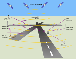
The local-area augmentation system (LAAS) is an all-weather aircraft landing system based on real-time differential correction of the GPS signal. Local reference receivers located around the airport send data to a central location at the airport. This data is used to formulate a correction message, which is then transmitted to users via a VHF Data Link. A receiver on an aircraft uses this information to correct GPS signals, which then provides a standard instrument landing system (ILS)-style display to use while flying a precision approach. The FAA has stopped using the term LAAS and has transitioned to the International Civil Aviation Organization (ICAO) terminology of ground-based augmentation system (GBAS). While the FAA has indefinitely delayed plans for federal GBAS acquisition, the system can be purchased by airports and installed as a Non-Federal navigation aid.
StarFire is a wide-area differential GPS developed by John Deere's NavCom and precision farming groups. StarFire broadcasts additional "correction information" over satellite L-band frequencies around the world, allowing a StarFire-equipped receiver to produce position measurements accurate to well under one meter, with typical accuracy over a 24-hour period being under 4.5 cm. StarFire is similar to the FAA's differential GPS Wide Area Augmentation System (WAAS), but considerably more accurate due to a number of techniques that improve its receiver-end processing.
The GPS-aided GEO augmented navigation (GAGAN) is an implementation of a regional satellite-based augmentation system (SBAS) by the Government of India. It is a system to improve the accuracy of a GNSS receiver by providing reference signals. The Airports Authority of India (AAI)'s efforts towards implementation of operational SBAS can be viewed as the first step towards introduction of modern communication, navigation and surveillance / air traffic management system over the Indian airspace.
Augmentation of a global navigation satellite system (GNSS) is a method of improving the navigation system's attributes, such as precision, reliability, and availability, through the integration of external information into the calculation process. There are many such systems in place, and they are generally named or described based on how the GNSS sensor receives the external information. Some systems transmit additional information about sources of error, others provide direct measurements of how much the signal was off in the past, while a third group provides additional vehicle information to be integrated in the calculation process.

AEROS satellites were to study the aeronomy i. e. the science of the upper atmosphere and ionosphere, in particular the F region under the strong influence of solar extreme ultraviolet radiation. To this end the spectrum of this radiation was recorded aboard by one instrument on the one hand and a set of 4 other instruments measuring the most important neutral uand iononized parameters at the satellite's position on the other.
MightySat-2.1, also known as P99-1 or Sindri was a small spacecraft developed by the Air Force Research Laboratory to test advanced technologies in imaging, communications, and spacecraft bus components in space.

Transit 3B was an American satellite which was launched in 1961 and operated by the United States Navy. It was a replacement for Transit 3A, which was lost in a launch failure the previous year. It carried instruments to demonstrate navigation and timing systems, and study geodesy to support the development of the Transit satellite navigation system.
The Surveillance Calibration satellites were a series of radar calibration satellites for the Naval Space Surveillance radar system. They were launched in the 1960s.

RADCAL was a radar calibration satellite launched and operated by the United States Air Force. It was active from June 1993 until it stopped communicating in May 2013.