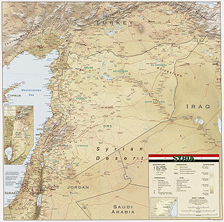
Syria is located in West Asia, north of the Arabian Peninsula, at the eastern end of the Mediterranean Sea. It is bordered by Turkey to the north, Lebanon and Israel to the west and southwest, Iraq to the east, and Jordan to the south. It consists of mountain ranges in the west and a steep area inland. In the east is the Syrian Desert and in the south is the Jabal al-Druze Range. The former is bisected by the Euphrates valley. A dam built in 1973 on the Euphrates created a reservoir named Lake Assad, the largest lake in Syria. The highest point in Syria is Mount Hermon on the Lebanese border at 2,814 metres or 9,232 feet. Between the humid Mediterranean coast and the arid desert regions lies a semiarid steep zone extending across three-quarters of the country, which receives hot, dry winds blowing across the desert. Syria is extensively depleted, with 28 percent of the land arable, 4 percent dedicated to permanent crops, 46 percent utilized as meadows and pastures, and only 3 percent forest and woodland.

Ancient Roman architecture adopted the external language of classical ancient Greek architecture for the purposes of the ancient Romans, but was different from Greek buildings, becoming a new architectural style. The two styles are often considered one body of classical architecture. Roman architecture flourished in the Roman Republic and to an even greater extent under the Empire, when the great majority of surviving buildings were constructed. It used new materials, particularly Roman concrete, and newer technologies such as the arch and the dome to make buildings that were typically strong and well engineered. Large numbers remain in some form across the former empire, sometimes complete and still in use today.
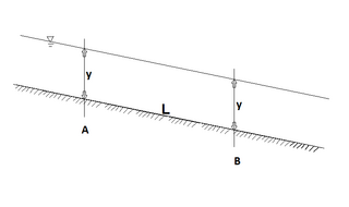
Hydraulics is a technology and applied science using engineering, chemistry, and other sciences involving the mechanical properties and use of liquids. At a very basic level, hydraulics is the liquid counterpart of pneumatics, which concerns gases. Fluid mechanics provides the theoretical foundation for hydraulics, which focuses on applied engineering using the properties of fluids. In its fluid power applications, hydraulics is used for the generation, control, and transmission of power by the use of pressurized liquids. Hydraulic topics range through some parts of science and most of engineering modules, and cover concepts such as pipe flow, dam design, fluidics and fluid control circuitry. The principles of hydraulics are in use naturally in the human body within the vascular system and erectile tissue.

The Decapolis was a group of ten Hellenistic cities on the eastern frontier of the Roman Empire in the Southern Levant in the first centuries BC and AD. They formed a group because of their language, culture, religion, location, and political status, with each functioning as an autonomous city-state dependent on Rome. They are sometimes described as a league of cities, although some scholars believe that they were never formally organized as a political unit.

A tunnel is an underground or undersea passageway. It is dug through surrounding soil, earth or rock, or laid under water, and is enclosed except for the portals, commonly at each end. A pipeline is not a tunnel, though some recent tunnels have used immersed tube construction techniques rather than traditional tunnel boring methods.

A qanat or kārīz is a system for transporting water from an aquifer or water well to the surface, through an underground aqueduct; the system originated approximately 3,000 years ago in what is now Iran. The function is essentially the same across North Africa and the Middle East but the system operates under a variety of regional names: qanat or kārīz in Iran, foggara in Algeria, khettara in Morocco, falaj in Oman and the United Arab Emirates, karez in Afghanistan and Pakistan, uyūn in Saudi Arabia, etc. The largest extant and functional qanat systems are located in Iran, Afghanistan, Oman, the oases of Turfan region of China, Algeria, and Pakistan.

Magdala was an ancient Jewish city on the shore of the Sea of Galilee, 5 km north of Tiberias. In the Babylonian Talmud it is known as Magdala Nunayya, and which some historical geographers think may refer to Tarichaea, literally: "the place of processing fish." It is believed to be the birthplace of Mary Magdalene. Until the 1948 Arab–Israeli War, a small Arab village, al-Majdal, stood at the site of ancient Magdala. The Israeli municipality of Migdal now extends into the area.

The Aqua Augusta, or Serino Aqueduct, was one of the largest, most complex and costliest aqueduct systems in the Roman world; it supplied water to at least eight ancient cities in the Bay of Naples including Pompeii and Herculaneum. This aqueduct was unlike any other of its time, being a regional network rather than being focused on one urban centre.

Hamat Gader is a hot springs site in the Yarmuk River valley, located in an area under Israeli control, near the Golan Heights and the border with Jordan.
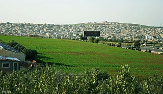
Al Husun is a town in northern Jordan, located 65 km (40 mi) north of Amman, and about 7 km (4 mi) south of Irbid. It has a population of 35,085. The region has fertile soil which along with the moderate climate allows the growing of high quality crops. Al Husn was known for its wine; now its main products are wheat and olive oil. Al Husn is registered in Jordanian government documents with the spelling 'Al Husun', and it is the administrative center of the Bani Obaid district.
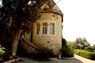
The German Protestant Institute of Archaeology (GPIA), Research Unit of the German Archaeological Institute, founded in 1900 is one of the most important biblical archaeological institutes in the Near East. Its German name is Deutsches Evangelisches Institut für Altertumswissenschaft des Heiligen Landes (DEI) which translates literally to the German Protestant Institute for Classical and Ancient Studies in the Holy Land.

Solomon's Pools are three ancient reservoirs located in the south-central West Bank, immediately to the south of al-Khader, about 3.5 kilometres (2.2 mi) southwest of Bethlehem, near the road to Hebron. The pools are located in Area A of the West Bank under the control of the Palestinian National Authority.

The Pont d'Aël is a Roman aqueduct located in a village of the same name in the comune of Aymavilles in Aosta Valley, northern Italy. It was built in the year 3BC for irrigation purposes and supplying water for the newly founded colony of Augusta Praetoria, which is now known as Aosta. The water was directed through a neighbouring valley 66 m above the floor of the Aosta valley, through a sophisticated system. The aqueduct is 6 km long in total. In addition to its unusual position, the construction, which was originally thought to be a three-story structure, shows more unique features such as a control corridor below the water line, as well as explicit private funding. Today, the water channel of the aqueduct serves as a public walking trail.

Capitolias was an ancient city east of the Jordan River, and is identified with the modern village of Beit Ras in the Irbid Governorate in northern Jordan. Anciently it was a town of Coele-Syria.

Umm Qais or Qays is a town in northern Jordan principally known for its proximity to the ruins of the ancient Gadara. It is the largest city in the Bani Kinanah Department and Irbid Governorate in the extreme northwest of the country, near Jordan's borders with Israel and Syria. Today, the site is divided into three main areas: the archaeological site (Gadara), the traditional village, and the modern town of Umm Qais.

Gadara, in some texts Gedaris, was an ancient Hellenistic city in what is now Jordan, for a long time member of the Decapolis city league, a former bishopric and present Latin Catholic titular see.
Water conflict in the Middle East and North Africa (MENA) primarily deals with three major river basins: the Jordan River Basin, the Tigris-Euphrates River Basin, and the Nile River Basin. The MENA region covers roughly 11.1 million square km. There are three major deserts in the MENA region:
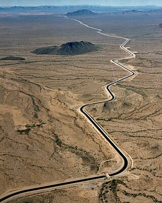
An aqueduct is a watercourse constructed to carry water from a source to a distribution point far away. In modern engineering, the term aqueduct is used for any system of pipes, ditches, canals, tunnels, and other structures used for this purpose. The term aqueduct also often refers specifically to a bridge carrying an artificial watercourse. Aqueducts were used in ancient Greece, ancient Near East, and ancient Rome. The simplest aqueducts are small ditches cut into the earth. Much larger channels may be used in modern aqueducts. Aqueducts sometimes run for some or all of their path through tunnels constructed underground. Modern aqueducts may also use pipelines. Historically, agricultural societies have constructed aqueducts to irrigate crops and supply large cities with drinking water.

Dium or Dion or Dia (Δία) was a city in ancient Coele-Syria mentioned by numerous ancient writers. According to Stephanus of Byzantium, the city was a foundation of Alexander the Great, and named after the city Dium in Macedon. It was also wrongly called Pella by some ancient writers.


