
In topography, prominence measures the height of a mountain or hill's summit relative to the lowest contour line encircling it but containing no higher summit within it. It is a measure of the independence of a summit. A peak's key col is a unique point on this contour line and the parent peak is some higher mountain, selected according to various criteria.

A summit is a point on a surface that is higher in elevation than all points immediately adjacent to it. The topographic terms acme, apex, peak, and zenith are synonymous.

These are lists of mountains and mountain ranges in Ireland. Those within Northern Ireland, or on the border, are marked with an asterisk, while the rest are within the Republic of Ireland. Where mountains are ranked by height, the definition of the "topographical prominence", used to classify the mountain, is noted. In British definitions, a height of 600 metres (1,969 ft) is required for a "mountain", whereas in Ireland, a lower threshold of 500 metres (1,640 ft) is sometimes advocated.

Slieve Donard is the highest mountain in Northern Ireland and the wider province of Ulster, with a height of 850 metres (2,790 ft). The highest of the Mourne Mountains, it is near the town of Newcastle on the eastern coast of County Down, overlooking the Irish Sea. It is also the highest mountain in the northern half of Ireland, and 7th highest on the island.

Lugnaquilla, at 925 metres (3,035 ft), is the 11th–highest peak in Ireland on the Arderin list, and 13th–highest on the Vandeleur-Lynam list, and the highest Irish mountain outside of Kerry. Lugnaquilla is the highest point in Wicklow, and in the province of Leinster. Lugnaquilla is in the Wicklow Mountains, and overlooks the Glen of Imaal to the west and Glenmalure to the east.

Mweelrea at 814 metres (2,671 ft), is the 26th-highest peak in Ireland on the Arderin scale, and the 34th-highest peak on the Vandeleur-Lynam scale. Mweelrea is situated near the apex of a "horseshoe-shaped" massif that includes the peaks of Ben Lugmore and Ben Bury, and which is located between Killary Harbour and Doo Lough, in Mayo, Ireland. Mweelrea is the provincial top for Connacht, and is noted for its southeastern cliff lined corries, and its views. The massif is called the Mweelrea Mountains or the Mweelrea Range.
Knockboy is a 706-metre-high mountain on the border between counties Cork and Kerry in Ireland.
Djouce at 725 metres (2,379 ft), is the 74th–highest peak in Ireland on the Arderin scale, and the 91st–highest peak on the Vandeleur-Lynam scale. Djouce is situated in the northeastern section of the Wicklow Mountains, and dominates the views of the Wicklow Mountains from Roundwood to Newtownmountkennedy. Djouce is one of a few Irish mountains for which the Irish Office of Public Works (OPW) maintain a boarded mountain trail, using railway sleepers, from its base to a point close to its summit; making the mountain even more accessible to the public, but while also protecting the underlying bog and soil from human erosion. Djouce is popular with hill walkers, and it lies along the 131-kilometre Wicklow Way; on its southern slopes at a senic viewpoint is the J.B. Malone memorial stone, dedicated to the creator of the Wicklow Way.
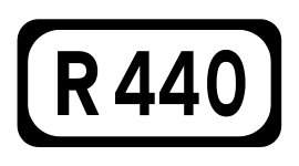
The R440 road is a regional road in Ireland linking Birr, County Offaly and Mountrath, County Laois. It passes through the village of Kinnity, Co. Offaly and from there climbs to near the high point of the Slieve Bloom Mountains, crosses into County Laois on the summit plateau and descents to Mountrath.

Mullaghmeen, at 258 metres (846 ft), is the is the county top for Westmeath in Ireland, and is the lowest county top in Ireland. Mullaghmeen is located in the Mullaghmeen Forest, known for having the largest planted beech forest in Europe.

Cupidstown Hill is the hihghest hill in County Kildare, Ireland, and lies on the fringes of the Dublin Mountains, 11.6 kilometres (7.2 mi) east of Naas.

Seefingan often spelt Seafingan is a mountain that straddles two county boundaries from its summit in Wicklow eastwards down into South Dublin, in Ireland.

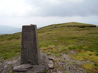
Arderin is a mountain on the border between Laois and Offaly in Ireland. With a height of 527 metres (1,729 ft) it is the highest point in the Slieve Bloom Mountains, and is both the highest point in County Laois and County Offaly.

Baunreaghcong is a mountain in Laois, Ireland. Baunreaghcong stands at a height of 509 metres.

Wolftrap Mountain is a mountain in counties Laois and Offaly, Ireland. The mountain is 487 metres (1,598 ft) high, making it the third-highest summit in Offaly, the fourth-highest mountain in the Slieve Bloom Mountains and the 602th-highest summit in Ireland. It is the most northerly summit of the Slieve Bloom range.
Ridge of Capard is a mountain in Laois, Ireland. Ridge of Capard's summit is at an altitude of 483 metres (1,585 ft), making it the third-highest point in Laois, the sixth-highest in the Slieve Bloom Mountains and the 614th-highest summit in Ireland.
Castleconor is a mountain in Laois, Ireland. Castleconor's summit is at an altitude of 407 metres making it the fourth-highest point in Laois, the ninth-highest point in the Slieve Bloom Mountains and the 907th-highest summit in Ireland.
Moylussa is a mountain in the Slieve Bernagh range in western Ireland, and the highest point in County Clare at 532 metres (1,745 ft).


