
These are lists of mountains and mountain ranges in Ireland. Those within Northern Ireland, or on the border, are marked with an asterisk, while the rest are within the Republic of Ireland. Where mountains are ranked by height, the definition of the "topographical prominence", used to classify the mountain, is noted. In British definitions, a height of 600 metres (1,969 ft) is required for a "mountain", whereas in Ireland, a lower threshold of 500 metres (1,640 ft) is sometimes advocated.

Sliabh Liag, sometimes Slieve League or Slieve Liag, is a mountain on the Atlantic coast of County Donegal, Ireland. At 596 metres (1,955 ft), it has some of the highest sea cliffs on the island of Ireland. Although less famous than the Cliffs of Moher in County Clare, Slieve League's cliffs reach almost three times higher.

Knocknarea is a large hill west of Sligo town in County Sligo, Ireland.

Arenig Fawr is a mountain in Snowdonia, North Wales, close to Llyn Celyn reservoir, alongside the A4212 between Trawsfynydd and Bala.

Mount Leinster is a 796-metre-high (2,612 ft) mountain in the Republic of Ireland. It straddles the border between Counties Carlow and Wexford, in the province of Leinster. It is the fifth-highest mountain in Leinster after Lugnaquilla 925m, Mullaghcleevaun 849m, Tonelagee 817m, and Cloghernagh 800m, and the highest of the Blackstairs Mountains. A 2RN transmission site tops the peak with a mast height of 122 m.

Rathnure is a small village on the R731 regional road about 12 km (7.5 mi) from the town of Enniscorthy, County Wexford, Ireland. The village is located at the foot of the Blackstairs Mountain, which borders County Carlow on the opposite side.
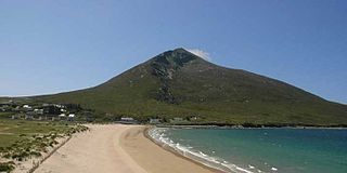
Slievemore is the second highest peak on Achill Island after Croaghaun, in County Mayo, Ireland. Its elevation is 671 metres.

Kildavin is a small village in County Carlow, Ireland. Situated on at the junction of the N80 National secondary road and the R724 regional road, it lies 5 km north of Bunclody, County Wexford at the northern end of the Blackstairs Mountains.
The Blackstairs Mountains run roughly north/south along the border between County Carlow and County Wexford in Ireland. The highest peak is Mount Leinster with a total height of 2612 ft/ 796 metres.

Croaghaun is a mountain in County Mayo, Ireland. At 688 metres (2,257 ft), it has the highest sea cliffs in Ireland as well as the third highest sea cliffs in Europe.

The R702 road is a regional road in Ireland which runs west-east from the R712 at Coolgrange in County Kilkenny through Gowran before crossing into County Carlow at Goresbridge. It continues to Borris, passes through the Blackstairs Mountains via the Scullogue Gap into County Wexford and continues east until it terminates at a junction with the R890 in Enniscorthy.

Kiltealy is a small village in the southeastern corner of Ireland. It is situated on the foothills of the Blackstairs Mountains in County Wexford at the junction of the R702 and R730 regional roads, on the eastern flank of the Blackstairs Mountains.

Ballymurphy, historically Ballymurchoe, is a village in County Carlow, Ireland on the R702 regional road. It lies on the western flank of the Blackstairs Mountains.

Black Rock Mountain is in the Blackstairs Mountains which are located on the Carlow-Wexford border.

Blackstairs Mountain in southern Leinster, is the second-highest mountain in the Blackstairs Mountains.The mountain stretches from Rathgeran to Gowlin at Cathaoirs Den
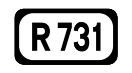
The R731 road is a regional road in County Wexford, Ireland. From its junction with the R730 it takes a route along the southeasterly flank of the Blackstairs Mountains to its junction with the R729 north of New Ross, where it terminates.

Cullahill Mountain is listed as a marilyn hill and a Special Area of Conservation in County Laois, Ireland. Cullahill with an elevation of 313 m (1,027 ft) gives its name to the local townland. It is also called Knockmannon Hill.
Drumcliff, or Drumcliffe, Dromcliffe is a civil parish in County Clare, Ireland. It includes the village of Inch and part of the town of Ennis.
St. Mullins is a Gaelic Athletic Association club located on the banks of the river Barrow beneath the Blackstairs mountains in Saint Mullins, County Carlow, Ireland. The club, founded in 1914, is first and foremost a hurling club.


