
The website PeakVisor states, as of February 2024 [update] , that there are 41 mountains or hills in County Dublin, Ireland, [1] while in the same month the Database of British and Irish Hills lists 16. [2]
The website PeakVisor states, as of February 2024 [update] , that there are 41 mountains or hills in County Dublin, Ireland, [1] while in the same month the Database of British and Irish Hills lists 16. [2]
The Database of British and Irish Hills includes Knockbane, the highest point of Lambay Island (elevation and prominence both 146 m (479 ft)). [2]

The Mourne Mountains, also called the Mournes or Mountains of Mourne, are a granite mountain range in County Down in the south-east of Northern Ireland. They include the highest mountains in Northern Ireland, the highest of which is Slieve Donard at 850 m (2,790 ft). The Mournes are designated an Area of Outstanding Natural Beauty and it has been proposed to make the area Northern Ireland's first national park. The area is partly owned by the National Trust and sees many visitors every year. The Mourne Wall crosses fifteen of the summits and was built to enclose the catchment basin of the Silent Valley and Ben Crom reservoirs.

The Wicklow Mountains form the largest continuous upland area in Ireland. They occupy the whole centre of County Wicklow and stretch outside its borders into the counties of Dublin, Wexford and Carlow. Where the mountains extend into County Dublin, they are known locally as the Dublin Mountains. The highest peak is Lugnaquilla at 925 metres.

A summit is a point on a surface that is higher in elevation than all points immediately adjacent to it. The topographic terms acme, apex, peak, and zenith are synonymous.

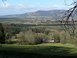
Kilmacanogue, officially Kilmacanoge, is a village in north County Wicklow, Ireland. It is southwest of Bray and is overlooked by Great Sugar Loaf mountain.
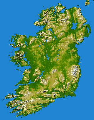
In these lists of mountains in Ireland, those within Northern Ireland, or on the Republic of Ireland – United Kingdom border, are marked with an asterisk, while the rest are within the Republic of Ireland. Where mountains are ranked by height, the definition of the topographical prominence used to classify the mountain, is noted. In British definitions, a height of 600 metres (1,969 ft) is required for a mountain, whereas in Ireland, a lower threshold of 500 metres (1,640 ft) is sometimes advocated.

Slieve Donard is the highest mountain in Northern Ireland and the wider province of Ulster, with a height of 850 metres (2,790 ft). The highest of the Mourne Mountains, it is near the town of Newcastle on the eastern coast of County Down, overlooking the Irish Sea. It is also the highest mountain in the northern half of Ireland, and seventh-highest on the island.

Kippure at 757 metres (2,484 ft), is the 56th-highest peak in Ireland on the Arderin scale, and the 72nd-highest peak on the Vandeleur-Lynam scale. Kippure is situated in the far northern sector of the Wicklow Mountains, where it lies on the border of the counties of Dublin and Wicklow in Ireland. Kippure is the County Top for Dublin, and its height and positioning over Dublin city have made its summit an important site for transmission masts, which are highly visible from a distance. Kippure's slopes feed into the Liffey Head Bog which forms the source of the River Liffey. The summit can be easily accessed from the east via a path that lies off the R115 road along the route to the Sally Gap.

Great Sugar Loaf at 501 metres (1,644 ft), is the 404th–highest peak in Ireland on the Arderin scale, however, being below 600 m it does not rank on the Vandeleur-Lynam or Hewitt scales. The mountain is in the far northeastern section of the Wicklow Mountains, in Ireland, and overlooks the village of Kilmacanogue. The profile of the mountain means it can be mistaken for a dormant volcano. It owes its distinctive shape, however, to the erosion-resistant metamorphosed deep-sea sedimentary deposit from which its quartzite composition was derived.

Camaderry at 699 metres (2,293 ft), is the 90th-highest peak in Ireland on the Arderin scale, and the 112th-highest peak on the Vandeleur-Lynam scale. Camaderry is situated in the southern sector of the Wicklow Mountains range, and forms a broad horseshoe around the valley of Glendalough with the hydroelectric station at Turlough Hill 681 metres (2,234 ft), and the mountains of Conavalla 734 metres (2,408 ft), and Lugduff 652 metres (2,139 ft). Camaderry has a subsidiary summit, Camaderry South East Top 677 metres (2,221 ft), and both lie across the deep Wicklow Gap from Tonelagee 817 metres (2,680 ft), which sits on the "central spine" of the Wicklow range.

Little Sugar Loaf is a 342 metres (1,122 ft) hill in the far northeastern sector of the Wicklow Mountains in Ireland. It does not have the elevation to rank on Arderin, Hewitt, or Vandeleur-Lynam scales, however, its prominence of 247 metres (810 ft) ranks it as a Marilyn.
Sugarloaf is a 552 metres (1,811 ft) peak in west Wicklow, Ireland that lies on the northern edge of the Glen of Imaal. With a prominence of only 14 metres (46 ft), it is not listed in any of the recognised categories of mountains in Ireland, and is a subsidiary summit of Lobawn 636 metres (2,087 ft), to the north.

The Wilkie Sugarloaf Trail is a hiking trail in northern Cape Breton Island in the Canadian province of Nova Scotia. The trail leads to the 411.8 metres (1,351 ft) summit of Wilkie Sugar Loaf in the Cape Breton Highlands.

Two Rock is a mountain in Dún Laoghaire–Rathdown, Ireland. It is 536 metres high and is the 382nd highest mountain in Ireland. It is the highest point of the group of hills in the Dublin Mountains which comprises Two Rock, Three Rock, Kilmashogue and Tibradden Mountains. The mountain takes its name from the two granite tors that lie to the south-east of the summit. From the summit, which is called Fairy Castle, there are views of much of the Dublin area from Tallaght to Howth to the north while Bray Head, Killiney Hill, the Great Sugar Loaf and the Wicklow Mountains are visible to the south. The summit area is mostly shallow bog while ferns and gorse cover the lower slopes. The mountain is also an important habitat for red grouse.
Strathmore is a mansion in Killiney, Dunleary-Rathdown in Ireland, and formerly the Official residence of the Canadian Ambassador to Ireland.

War Hill at 686 metres (2,251 ft), is the 106th–highest peak in Ireland on the Arderin scale, and the 129th–highest peak on the Vandeleur-Lynam scale. War Hill is in the far northeastern section of the Wicklow Mountains, in Wicklow, Ireland. Due to its remote setting, it is usually only accessed as part of a larger hill-walking route taking in other neighbouring peaks such as Djouce or Maulin. One of the few distinguishing landmarks in the area is the Coffin Stone that lies in the saddle between War Hill and Djouce, whose origon is uncertain.

Wilkie Sugar Loaf is a Canadian peak in the Cape Breton Highlands near the community of Sugar Loaf in the province of Nova Scotia.
Cualu or Cuala was a territory in Gaelic Ireland south of the River Liffey encompassing the Wicklow Mountains.
Prince William's Seat at 555 metres (1,821 ft), is the 296th–highest peak in Ireland on the Arderin scale, however, it does not have the elevation to quality as a Vandeleur-Lynam. Prince William's Seat is on the border of the Wicklow Mountains and Dublin Mountains in Ireland, and lies on the northern side of the Glencree valley, positioned at its entrance. Prince William's Seat is separated by a small col from neighbouring Knocknagun, which is also 555 metres (1,821 ft) in height. Prince William's Seat and Knocknagun are popular peaks with hill-walkers.
