Tara Hill, County Wexford

Last updated

Tara Hill
Torrchoill
TaraHill1590c.jpg
Tara Hill, from the northwest
Highest point
Elevation 253 m (830 ft) [1]
Prominence 198 m (650 ft) [1]
Listing Marilyn Village
Coordinates 52°41′56″N6°13′04″W / 52.699°N 6.2177°W / 52.699; -6.2177
Geography
Island of Ireland relief location map.png
Red triangle with thick white border.svg
Tara Hill
Location in Ireland
Location County Wexford, Ireland
OSI/OSNI grid T205623
Topo map OSi Discovery 62

Tara Hill (Torrchoill in Irish) is an isolated hill and associated village near the Irish Sea coast in north County Wexford, Ireland. Though only 253 metres (830 feet) high, it dominates the landscape of northeast Wexford. It provides extensive views of the Wexford coast line, from Courtown harbour to Castletown.

Contents

Location

Tara Hill is situated at a particularly high point along the south east coast of Ireland and is surrounded by flat residential and agricultural land. There is a small village located at the heart of the hill. Tara Hill is located approximately 7.1 km from Gorey Town Centre and 107.5 km from Dublin.

Contemporary village

Tara Hill while not considered a village has many facilities including a church, a primary school (St Kevins), the local shop selling general groceries shut her doors in 2018 and a drumming school is using the building now. Businesses in the area include Tara Hill Estate, Sound Out Rhythm Music School, Tara Hill Honey and Ballinglen Stud.

The closest villages to Tara Hill are Castletown, Ballymoney and Courtown. Nearby Gorey serves as a market town for the area, with a range of grocery stores, fashion boutiques, and restaurants including, Katie Daly's, [2] The Kitchen, [3] .

Tara Hill has two main walking trails around the Marilyn starting close to the village centre [see Tourism].

The village is closely linked to Dublin by the M11/N11 National Primary Route, and the national rail network from gorey connects it to Rosslare Europort.

Geography

Due to its height relative to the surrounding landscape this hill qualifies as a Marilyn. It should not be confused with the much better known but much less prominent Royal Hill of Tara in County Meath, which is only 159m high.

The summit is marked by a cairn from where one can see nearby Gorey, Courtown and other villages and town-lands and views of the North Wexford coast.

Though only 253 metres high, it dominates the landscape of northeast Wexford and can be seen from Gorey Town Centre.

History

Saint Caemhan or Kevin or Cavan, as the name is variously spelt is the Patron Saint of Tara Hill and the site of the old church founded by him is situated at Kilcavan at the north side of the hill under a cliff by the road. [4]

The community in Tara Hill and Ballymoney announced in 2009 that they were making efforts to preserve the past, with plans to produce a new book on the social history of the area. A 'Minding Memories' night was held in Tara Hill to offer locals a chance to record their memories of the area back as far as the war years, and even earlier. It is said that several locals recalled Spencer's Hall on the bank of the North Beach, where dances were held in the 1940s and 1950s. Its foundations can still be seen. Others recalled Clince's Hall at the bottom of the Sea Road, where there was also a guest house. The hall is now a private dwelling. It too was used for dances and also for a table tennis club. Other people recalled the farming enterprises which were used to make money but also provided for the families themselves. Accounts have been given how Tara Hill Church also doubled as a school until the 'new school' was built in 1939. Other people recalled going to Gorey for the cattle fair day on a Friday, and how there were four different grocery stores in the town, each one patronised by people from different villages. The people of Tara Hill used to shop in Dwyers close to where the Loch Garman Arms is now. Several accounts of sightings of apparitions and strange lights in the woods of Tara Hill have also been recorded in local history adding to legend that it is reportedly haunted. [5]

Tourism

B&B's in the area include Tara Hill Lodge, Hillside House Bed & Breakfast, Daru House B&B, and Tara Haven. Seafield Hotel & Spa Resort in nearby Ballymoney, serves as a hotel for tourists staying in the local area. The area also has a number of beaches, including Clone Strand and nearby Ballymoney Beach. There are two trails on Tara Hill, starting from two different trailheads (Crab Tree – Blue and Cemetery – Red). The Red Slí an tSuaimhnais trail begins from Tara Hill cemetery just beyond the village itself. The Blue Slí na n-Óg trail, beginning from the Ballinacarrig parking place (known locally as the Crab Tree) goes to the higher slopes of Tara Hill itself. [6]

Schools

St. Kevin's National School is located in Tara Hill village. The school caters for junior infants to 6th class pupils. The school regularly organises outings to nearby Tara Hill and Glendalough, and has a vegetable garden on its premises.

Sports

The local GAA club (Castletown Liam Mellows) is located just meters down the road on the Castletown, Tara Hill border.

Religion

St. Kevins Catholic church is located at Kilcavan Lower in Tara Hill.

See also

Related Research Articles

<span class="mw-page-title-main">County Wexford</span> County in Ireland

County Wexford is a county in Ireland. It is in the province of Leinster and is part of the Southern Region. Named after the town of Wexford, it was based on the historic Gaelic territory of Hy Kinsella, whose capital was Ferns. Wexford County Council is the local authority for the county. The population of the county was 163,527 at the 2022 census.

<span class="mw-page-title-main">Castletown, Isle of Man</span> A town in the Isle of Man

Castletown is a town in the Isle of Man, geographically within the historical parish of Malew but administered separately. Lying at the south of the island, it was the Manx capital until 1869. The centre of town is dominated by Castle Rushen, a well-preserved medieval castle, originally built for a Viking king.

<span class="mw-page-title-main">Gorey</span> Town in County Wexford, Ireland

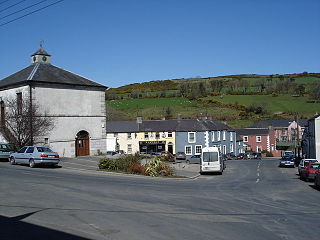
Gorey is a market town in north County Wexford, Ireland. It is bypassed by the main M11 Dublin to Wexford road. The town is also connected to the railway network along the same route. Local newspapers include the Gorey Guardian.

<span class="mw-page-title-main">Enniscorthy</span> Town in County Wexford, Ireland

Enniscorthy is the second-largest town in County Wexford, Ireland. The town is located on the picturesque River Slaney and in close proximity to the Blackstairs Mountains and Ireland's longest beach, Curracloe.

<span class="mw-page-title-main">Castlebridge</span> Town in County Wexford, Ireland

Castlebridge is a small town on the R741 regional road in County Wexford, Ireland, around 5 km north of Wexford Town. It is located near the River Slaney and just north of Wexford Harbour. Castlebridge is a rapidly expanding suburb of Wexford Town; its population has almost tripled in 20 years, increasing from 783 in 1996 to a population of 1,840 in 2016.

<span class="mw-page-title-main">Kilmuckridge</span> Village in County Wexford, Ireland

Kilmuckridge, formerly Ford or The Ford, is a village in County Wexford in Ireland, near the Irish Sea coast. As of the 2016 census, the village had a population of 722 people, having more than tripled in size in the 20 years since the 1996 census. It is known for the nearby beach at Morriscastle.

<span class="mw-page-title-main">Tinahely</span> Village in County Wicklow, Ireland

Tinahely is a village in County Wicklow in Ireland. It is a market town in the valley of the River Derry, a tributary of the River Slaney.

Anthony Perry, known as the "screeching general" was one of the most important leaders of the United Irish Wexford rebels during the 1798 rebellion.

<span class="mw-page-title-main">Courtown</span> Village in County Wexford, Ireland

Courtown is a village in County Wexford, Ireland. It was developed after Lord Courtown ordered the construction of a harbour during the Famine years, 1839–1846. The economic boost of the new harbour led to a small village developing with fishing being the primary economy of the village.

<span class="mw-page-title-main">Craanford</span> Village in County Wexford, Ireland

Craanford is a small village in north County Wexford, Ireland, situated on the R725 regional road midway between Gorey and Carnew.

<span class="mw-page-title-main">Coolgreany</span> Village in County Wexford, Ireland

Coolgreany is a village located in north County Wexford in Ireland, in the shadow of Croghan Mountain, overlooking Tara Hill in the extreme north of County Wexford.

<span class="mw-page-title-main">Inch, County Wexford</span> Village in County Wexford, Ireland

Inch is located in County Wexford, Ireland on the R772 road between Arklow and Gorey. In September 2007 Inch was bypassed, having formerly been on the N11 Dublin to Wexford road. There is a creamery in Inch run by Glanbia.

<span class="mw-page-title-main">Blackwater, County Wexford</span> Village in County Wexford, Ireland

Blackwater is a rural village in County Wexford, Ireland. It lies mostly within the townland of Ballynaglogh on the R742 regional road 16 km (9.9 mi) north of Wexford town.

<span class="mw-page-title-main">Ballyduff, County Wexford</span> Village in County Wexford, Ireland

Ballyduff is a small rural hamlet-village in the southeastern corner of Ireland. It is situated in County Wexford 5 km (3.1 mi) north of the town Ferns, and northwest of the village of Camolin.

<span class="mw-page-title-main">Oulart</span> Village in County Wexford, Ireland

Oulart, is a small village in the southeastern corner of Ireland. It is situated in County Wexford just off the R741 regional road halfway between the towns of Gorey to the north and Wexford to the south.

<span class="mw-page-title-main">Riverchapel</span> Village in County Wexford, Ireland

Riverchapel is a village in County Wexford, Ireland. It lies just south of Courtown on the R742 regional road and has been a summer holiday resort for Dublin people at least since tourists started to arrive in 1863, when the railway line from Dublin reached nearby Gorey. The population of the area has also grown significantly since the mid-2000s. Riverchapel is 1 km inland from the Irish Sea coast and has merged into the adjoining village of Courtown.

<span class="mw-page-title-main">Castletown, County Wexford</span> Village in Leinster, Ireland

Castletown, historically called Ballycaslane, is a small village in northeast County Wexford, Ireland.

The Ballagh or Ballaghkeen is a village in the southeastern corner of Ireland. It is situated in County Wexford just off the R741 regional road halfway between the towns of Gorey to the north and Wexford to the south. As of the 2016 census, the village had a population of 515 people.

Gorey is a market town in north County Wexford, Ireland.

<span class="mw-page-title-main">Marlfield House</span> 19th Century Irish country house

Marlfield House, County Wexford is an Irish country house built in 1852 and was one of the two houses owned by the Earls of Courtown. An example of a rural regency style house, it was a dower house on the Courtown House Estate. It is now a hotel.

References

  1. 1 2 "North Wexford Area - Tara Hill". MountainViews. Ordnance Survey Ireland . Retrieved 2 July 2015.
  2. "Katie Dalys - Gorey". Katiedalys.ie. Retrieved 27 May 2018.
  3. "The Kitchen - Gorey". thekitchengorey.ie. Retrieved 27 May 2018.
  4. "North Wexford Tourism - Market House, Main Street, Gorey, Co.Wexford, Ireland". Archived from the original on 16 December 2008. Retrieved 27 December 2008.
  5. "Book being compiled on social history of Tara Hill".
  6. "Walking Routes - Tara Hill". walking routes.ie. Retrieved 27 May 2018.