Garsten

Last updated
Garsten
Garsten Ehem.Klosterkirche Am Platzl (01).JPG
Wappen at garsten.png
Coat of arms
Austria adm location map.svg
Red pog.svg
Garsten
Location within Austria
Coordinates: 48°01′18″N14°24′32″E / 48.02167°N 14.40889°E / 48.02167; 14.40889 Coordinates: 48°01′18″N14°24′32″E / 48.02167°N 14.40889°E / 48.02167; 14.40889
Country Austria
State Upper Austria
District Steyr-Land
Government
   Mayor Anton Silber (ÖVP)
Area
[1]
  Total53.21 km2 (20.54 sq mi)
Elevation
298 m (978 ft)
Population
(2018-01-01) [2]
  Total6,711
  Density130/km2 (330/sq mi)
Time zone UTC+1 (CET)
  Summer (DST) UTC+2 (CEST)
Postal code
4451
Area code 07252
Vehicle registration SE
Website www.garsten.ooe.gv.at

Garsten is a municipality in the district of Steyr-Land in the Austrian state of Upper Austria.

Austria Federal republic in Central Europe

Austria, officially the Republic of Austria, is a country in Central Europe comprising 9 federated states. Its capital, largest city and one of nine states is Vienna. Austria has an area of 83,879 km2 (32,386 sq mi), a population of nearly 9 million people and a nominal GDP of $477 billion. It is bordered by the Czech Republic and Germany to the north, Hungary and Slovakia to the east, Slovenia and Italy to the south, and Switzerland and Liechtenstein to the west. The terrain is highly mountainous, lying within the Alps; only 32% of the country is below 500 m (1,640 ft), and its highest point is 3,798 m (12,461 ft). The majority of the population speaks local Bavarian dialects as their native language, and German in its standard form is the country's official language. Other regional languages are Hungarian, Burgenland Croatian, and Slovene.

Upper Austria State of Austria

Upper Austria is one of the nine states or Bundesländer of Austria. Its capital is Linz. Upper Austria borders on Germany and Czechia, as well as on the other Austrian states of Lower Austria, Styria, and Salzburg. With an area of 11,982 km2 (4,626 sq mi) and 1.437 million inhabitants, Upper Austria is the fourth-largest Austrian state by land area and the third-largest by population.

History

Garsten was first mentioned as Garstina in documentation around 990, and a monastery was founded there in 1082. After being fully rebuilt in Baroque style in the late 17th century, the Benedictine monastery was converted to a prison in 1850, a function it fulfills to this day. [3]

Baroque cultural movement, starting around 1600

The Baroque is a highly ornate and often extravagant style of architecture, music, painting, sculpture and other arts that flourished in Europe from the early 17th until the mid-18th century. It followed the Renaissance style and preceded the Rococo and Neoclassical styles. It was encouraged by the Catholic Church as a means to counter the simplicity and austerity of Protestant architecture, art and music, though Lutheran Baroque art developed in parts of Europe as well. The Baroque style used contrast, movement, exuberant detail, deep colour, grandeur and surprise to achieve a sense of awe. The style began at the start of the 17th century in Rome, then spread rapidly to France, northern Italy, Spain and Portugal, then to Austria and southern Germany. By the 1730s, it had evolved into an even more flamboyant style, called rocaille or Rococo, which appeared in France and central Europe until the mid to late 18th century.

Related Research Articles

Sankt Florian Place in Upper Austria, Austria

Sankt Florian is a town in the Austrian state of Upper Austria. It is 10 miles (16 km) from Linz.

Hard, Austria Place in Vorarlberg, Austria

Hard is a town in the westernmost Austrian state of Vorarlberg, directly on Lake Constance. Hard's attractions include the Strandbad and the Grünerdamm. Hard is also famous for its skatepark.

Dürnstein Place in Lower Austria, Austria

Dürnstein is a small town on the Danube river in the Krems-Land district, in the Austrian state of Lower Austria. It is one of the most-visited tourist destinations in the Wachau region and also a well-known wine growing area. The municipality consists of the Katastralgemeinden of Dürnstein, Oberloiben, and Unterloiben.

Mauerbach Place in Lower Austria, Austria

Mauerbach is a town on the western boundary of Vienna, Austria.

Zwettl Place in Lower Austria, Austria

Zwettl is a town and district capital of the Austrian state of Lower Austria. It is chiefly known as the location of Zwettl Abbey, first mentioned in October 1139.

Admont Place in Styria, Austria

Admont is a town in the Austrian state of Styria. It is historically most notable for Admont Abbey, a monastery founded in 1074.

Sankt Lambrecht Place in Styria, Austria

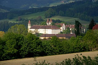
Sankt Lambrecht is a market town in the district of Murau in Styria, Austria. It is known for St. Lambrecht's Abbey, one of the most important Benedictine monasteries in Austria. The monastery complex and its gardens are part of the Zirbitzkogel-Grebenzen nature park.

Ossiach Place in Carinthia, Austria

Ossiach is a municipality in the Feldkirchen District in the Austrian state of Carinthia. The small settlement is mainly known for Ossiach Abbey.

Satteins Place in Vorarlberg, Austria

Satteins is a town in the Austrian state of Vorarlberg.

Sankt Georgen am Längsee Place in Carinthia, Austria

Sankt Georgen am Längsee is a municipality in the district of Sankt Veit an der Glan in Carinthia, Austria.

Seitenstetten Place in Lower Austria, Austria

Seitenstetten is a town in the district of Amstetten in Lower Austria in Austria.

Heiligenkreuz, Lower Austria Place in Lower Austria, Austria

Heiligenkreuz is a municipality in the district of Baden, in the Austrian state of Lower Austria. It is known for the Cistercian monastery of Heiligenkreuz Abbey, the associated papal college Benedict XVI and the Catholic Leopoldinum seminary.

Guntramsdorf Place in Lower Austria, Austria

Guntramsdorf is a town in the district of Mödling in the Austrian state of Lower Austria. As part of the "Industrieviertel", the industrial region in the southeast of Lower Austria, it is well connected to the country capital Vienna. In the west of the town lies the "Wienerwald", an outlier of the Alpine foothills, featuring recreational forest areas and hiking trails, and the southeast of "Guntramsdorf" extends into the thermal basin called "Wiener Becken".

Telfs Place in Tyrol, Austria

Telfs is a market town in the district of Innsbruck-Land in the Austrian state of Tyrol, 27 kilometres west of Innsbruck. It is the third largest municipality in Tyrol. Telfs received its status in 1908 and maintains its own district court.

Schlierbach, Austria Place in Upper Austria, Austria

Schlierbach is a municipality in the district of Kirchdorf an der Krems in the Austrian state of Upper Austria.

Spital am Pyhrn Place in Upper Austria, Austria

Spital am Pyhrn is a municipality in the district of Kirchdorf an der Krems in the Austrian state of Upper Austria.

Windischgarsten Place in Upper Austria, Austria

Windischgarsten is a municipality in the district of Kirchdorf an der Krems in the Austrian state of Upper Austria. Since 1964, the town has been classified as a Luftkurort, a mountain spa town.

Dimbach, Austria Place in Upper Austria, Austria

Dimbach is a municipality in the district Perg in Upper Austria, Austria. It had a population of 1015 according to the 2015 census.

Altschwendt Place in Upper Austria, Austria

Altschwendt is a municipality in the district of Schärding in the Austrian state of Upper Austria.

Ternberg Place in Upper Austria, Austria

Ternberg is a municipality in the district of Steyr-Land in the Austrian state of Upper Austria.

References

  1. "Dauersiedlungsraum der Gemeinden Politischen Bezirke und Bundesländer - Gebietsstand 1.1.2018". Statistics Austria. Retrieved 10 March 2019.
  2. "Einwohnerzahl 1.1.2018 nach Gemeinden mit Status, Gebietsstand 1.1.2018". Statistics Austria. Retrieved 9 March 2019.
  3. Benediktinerstift - Gemeinde Garsten