Waldneukirchen

Last updated
Waldneukirchen
Waldneukirchen total-3981.jpg
AUT Waldneukirchen COA.jpg
Austria adm location map.svg
Red pog.svg
Waldneukirchen
Location within Austria
Coordinates: 47°59′49″N14°15′41″E / 47.99694°N 14.26139°E / 47.99694; 14.26139 Coordinates: 47°59′49″N14°15′41″E / 47.99694°N 14.26139°E / 47.99694; 14.26139
Country Austria
State Upper Austria
District Steyr-Land
Government
   Mayor Karl Schneckenleitner (ÖVP)
Area
[1]
  Total26.52 km2 (10.24 sq mi)
Elevation
446 m (1,463 ft)
Population
 (2018-01-01) [2]
  Total2,242
  Density85/km2 (220/sq mi)
Time zone UTC+1 (CET)
  Summer (DST) UTC+2 (CEST)
Postal code
4595
Area code 07258
Vehicle registration SE
Website www.waldneukirchen.at

Waldneukirchen is a municipality in the district of Steyr-Land in the Austrian state of Upper Austria.

Contents

Geography

The extension of Waldneukirchen is 5.5 km from north to south and 8.5 km from west to east. 14.8% of the area is forested, 74.2% is used for agriculture (for comparison: this value is 41% in the political district of Steyr-Land). [3]

The municipality extends from the Molasse area of the Alpine foothills to the Steyrtal. The place is also called "The Gate to the Steyrtal". The sediments of the Flysch Zone are on the one hand deposits of a sea from the Upper Cretaceous, on the other hand Marl and sandstone sediments from the Old Tertiary. The landscape here in Waldneukirchen was decisively shaped in the Quaternary, namely in the Ice Ages. In the cold periods of the Günz-, Mindel-, and Rissis Age, the Krems glacier, coming from the south, pushed with its huge glacier tongue far into the Alpine foothills and stored in the municipality of Waldneukirchen abounds in massive moraine trees made of gravel, sand and clay. The glacier brooks that emerged from the ice, forerunners of the Steyr, built up bulkheads in the ice-free area during the cold times. During the warm periods, some of these gravel deposits are then removed through the cutting channels. Large parts of the northern plateau of the municipality belong to this gravel area of the elevated terrace above the Steyr river, up to which the municipality extends in the south- At the time of the most recent glaciation (Würm), silt-rich cover layers were blown up in all ice-free (periglacial) parts of the plateau northwest of the Steyr. Today they represent the covering clay. The rainwater is not diverted into the depths, but flows mostly in the municipality to the north via Fernbach, Binderbach into the Krems. In this way, the erosion has shaped the moat landscape so characteristic of the flysch. The agricultural soils in the municipality of Waldneukirchen consist - according to the explanations of the soil map 1: 25000 - in their A-Horizont s mainly of loamy silt, are medium humus and lime-free, and clearly crumbly, the B-Horizont e are mostly loamy silt or sandy loam, which is usually free of lime. Below that, from a depth of approx. 50 cm, lies the horizon with lime-free, loamy silt. [4]

Municipal organization

The municipal area comprises the following seven localities:

Population development

In 2001 the community had 2254 inhabitants according to the census, in 2019 a little less: 2194. The population development since the 1st VZ 1869 (1732 Ew. Then, since then the population has been slowly increasing) and other socio-economic parameters for the community can be found in the. [5] The Statistics.at sample census in 2006 revealed 1104 persons in employment (employment rate of 51.3%); after the position in the job only 14% in agriculture and forestry, 25.7% in the production of goods. [6] In 2017 the number of people employed in agriculture and forestry decreased to 8.2% (= 100 people) [7]

Waldneukirchen

Related Research Articles

Fulpmes Place in Tyrol, Austria

Fulpmes is a market town and a municipality in Stubaital, Tyrol, Austria. In 2015 it had a population of 4,250, of whom 14.5% did not have Austrian nationality. Fulpmes is the center of iron production in the area, and lies at the base of the Schlick 2000 ski area.

Krems, Carinthia Place in Carinthia, Austria

Krems in Kärnten is a municipality in the district of Spittal an der Drau in Carinthia in Austria.

Furth bei Göttweig Place in Lower Austria, Austria

Furth bei Göttweig is a town and municipality in the district of Krems-Land in the Austrian state of Lower Austria. The municipality consists of the following populated places:

Rohrendorf bei Krems is a municipality in the district of Krems-Land in the Austrian state of Lower Austria.

Rossatz-Arnsdorf Place in Lower Austria, Austria

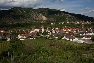
Rossatz-Arnsdorf is a town in the district of Krems-Land in the Austrian state of Lower Austria. It is located in the Wachau valley of the Danube, a popular destination for tourists, and has excellent views of the ruins of castle Dürnstein, where King Richard the Lion-Heart of England was held captive by Duke Leopold V.

Senftenberg, Austria Place in Lower Austria, Austria

Senftenberg is a town in the district of Krems-Land in the Austrian state of Lower Austria.

Gießhübl Place in Lower Austria, Austria

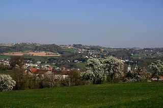
Gießhübl is a town in the district of Mödling in the Austrian state of Lower Austria. It is located in the south of Vienna, the Austrian capital, neighboring the nature protection area Föhrenberge. With an altitude of 416 m, Gießhübl is the highest-located wine-growing district in Lower Austria. Originally Gießhübl was an agrarian village. Today it is mainly a residential area because of its vicinity to Vienna and the direct connection to the highway A21.

Kartitsch Place in Tyrol, Austria

Kartitsch is a municipality in the district of Lienz in the Austrian state of Tyrol.

Leutasch is a municipality in the northern part of the district Innsbruck-Land in the Austrian state of Tyrol about 30 km northwest of Innsbruck and 10 km northwest of Seefeld in Tirol

Steinbach an der Steyr Place in Upper Austria, Austria

Steinbach an der Steyr is a municipality in the district of Kirchdorf an der Krems in the Austrian state of Upper Austria.

Wartberg an der Krems Place in Upper Austria, Austria

Wartberg an der Krems is a municipality in the district of Kirchdorf an der Krems in the Austrian state of Upper Austria.

Neuhofen an der Krems Place in Upper Austria, Austria

Neuhofen an der Krems is a municipality in the district Linz-Land in the Austrian state of Upper Austria.

Adlwang Place in Upper Austria, Austria

Adlwang is a municipality in the district of Steyr-Land in the Austrian state of Upper Austria.

Aschach an der Steyr Place in Upper Austria, Austria

Aschach an der Steyr is a municipality in the district of Steyr-Land in the Austrian state of Upper Austria.

Rohr im Kremstal Place in Upper Austria, Austria

Rohr im Kremstal is a municipality in the district of Steyr-Land in the Austrian state of Upper Austria.

Sierning Place in Upper Austria, Austria

Sierning is a municipality in the district of Steyr-Land in the Austrian state of Upper Austria.

Ternberg Place in Upper Austria, Austria

Ternberg is a municipality in the district of Steyr-Land in the Austrian state of Upper Austria.

Weyer is a municipality in the district of Steyr-Land in the Austrian state of Upper Austria.

Geology of Surrey

The geology of Surrey is dominated by sedimentary strata from the Cretaceous, overlaid by clay and superficial deposits from the Cenozoic.

Glaciofluvial deposits Sediments/deposits formed from ice sheets or glaciers

Glaciofluvial deposits or Glacio-fluvial sediments consist of boulders, gravel, sand, silt and clay from ice sheets or glaciers. They are transported, sorted and deposited by streams of water. The deposits are formed beside, below or downstream from the ice. They include kames, kame terraces and eskers formed in ice contact and outwash fans and outwash plains below the ice margin. Typically the outwash sediment is carried by fast and turbulent fluvio-glacial meltwater streams, but occasionally it is carried by catastrophic outburst floods. Larger elements such as boulders and gravel are deposited nearer to the ice margin, while finer elements are carried farther, sometimes into lakes or the ocean. The sediments are sorted by fluvial processes. They differ from glacial till, which is moved and deposited by the ice of the glacier, and is unsorted.

References

  1. "Dauersiedlungsraum der Gemeinden Politischen Bezirke und Bundesländer - Gebietsstand 1.1.2018". Statistics Austria. Retrieved 10 March 2019.
  2. "Einwohnerzahl 1.1.2018 nach Gemeinden mit Status, Gebietsstand 1.1.2018". Statistics Austria. Retrieved 9 March 2019.
  3. mapfinder.aspx? menuonr = 221153105 see also "Digital local map"
  4. Federal Institute for Agriculture: Explanations of the soil map 1: 25000; Mapping area Grünburg, Upper Austria. KB 127. Vienna 1988
  5. //www.statistik.at/blickgem/gemDetail.do? gemnr = 41518 municipal data from statistics austria]
  6. statistik.at: sample count 2006 : Population by employment status, employed persons by job status and economic affiliation (PDF; 10 kB)
  7. Employment statistics 2017