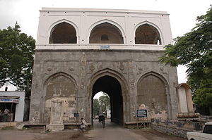
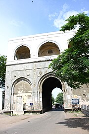
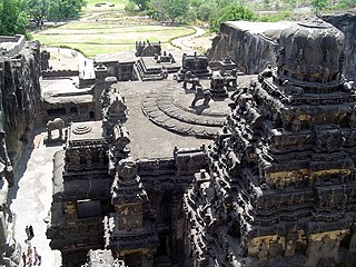
Aurangabad, officially known as Chhatrapati Sambhaji Nagar, or Chhatrapati Sambhajinagar, is a city in the Indian state of Maharashtra. It is the administrative headquarters of Aurangabad district and is the largest city in the Marathwada region. Located on a hilly upland terrain in the Deccan Traps, Aurangabad is the fifth-most populous urban area in Maharashtra after Mumbai, Pune, Nagpur and Nashik with a population of 1,175,116. The city is known as a major production center of cotton textile and artistic silk fabrics. Several prominent educational institutions, including Dr. Babasaheb Ambedkar Marathwada University, are located in the city. The city is also a popular tourism hub, with tourist destinations like the Ajanta and Ellora caves lying on its outskirts, both of which have been designated as UNESCO World Heritage Sites since 1983. Other tourist attractions include the Aurangabad Caves, Devagiri Fort, Grishneshwar Temple, Jama Mosque, Bibi Ka Maqbara, Himayat Bagh, Panchakki and Salim Ali Lake. Historically, there were 52 Gates in Aurangabad, some of them extant, because of which Aurangabad is nicknamed as the "City of Gates". In 2019, the Aurangabad Industrial City (AURIC) became the first greenfield industrial smart city of India under the country's flagship Smart Cities Mission.

Shaniwar Wada is a historical fortification in the city of Pune, India.
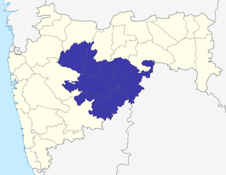
Marathwada is a proposed state and geographical region of the Indian state of Maharashtra. It was formed during the Nizam's rule and was part of the then Hyderabad State. The region coincides with the Chhatrapati Sambhajinagar division of Maharashtra. It borders the states of Karnataka and Telangana, and it lies to the west of the Vidarbha and east of Uttar Maharashtra regions of Maharashtra. The largest city of Marathwada is Chhatrapati Sambhajinagar. Its people speak Marathi and Deccani Urdu.
Paithan ['pəɪ.ʈʰaɳ], historically Pratiṣṭhāna [pɾə'tɪʂʈʰana], is a town with municipal council in Aurangabad district, Maharashtra, Maharashtra, India. Paithan is located 56 kilometres (35 mi) south of present-day Chatrapati Sambhajinagar on the banks of the Godavari River. It was the capital of the Satavahana dynasty, which ruled from the second century BCE to the second century CE. It is one of the few inland towns mentioned in the famous first-century Greek book, the Periplus of the Erythraean Sea.
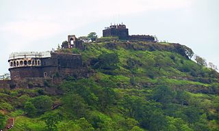
DaulatabadFort originally DeogiriFort, is a historic fortified citadel located in Daulatabad village near Aurangabad, Maharashtra, India. It was the capital of the Yadavas, for a brief time the capital of the Delhi Sultanate, and later a secondary capital of the Ahmadnagar Sultanate.

Mughal architecture is the type of Indo-Islamic architecture developed by the Mughals in the 16th, 17th and 18th centuries throughout the ever-changing extent of their empire in the Indian subcontinent. It developed from the architectural styles of earlier Muslim dynasties in India and from Iranian and Central Asian architectural traditions, particularly Timurid architecture. It also further incorporated and syncretized influences from wider Indian architecture, especially during the reign of Akbar. Mughal buildings have a uniform pattern of structure and character, including large bulbous domes, slender minarets at the corners, massive halls, large vaulted gateways, and delicate ornamentation; examples of the style can be found in modern-day Afghanistan, Bangladesh, India and Pakistan.
Aurangabad district, officially known as Chhatrapati Sambhaji Nagar district, is one of the 36 districts of the state of Maharashtra in western India. It borders the districts of Nashik to the west, Jalgaon to the north, Jalna to the east, and Ahmednagar to the south. The city of Aurangabad houses the district's administrative headquarters. The district has an area of 10,100 km2, of which 37.55% is urban and the rest is rural. Aurangabad District is a major tourism region in Marathwada.

Buland Darwaza, or the "Door of Victory", was built in 1575 by Mughal emperor Akbar to commemorate his victory over Gujarat. It is the main entrance to the Jama Masjid at Fatehpur Sikri, which is 43 km from Agra, India.

Panhala fort, is located in Panhala, 20 kilometres northwest of Kolhapur in Maharashtra, India. It is strategically located looking over a pass in the Sahyadri mountain range which was a major trade route from Bijapur in the interior of Maharashtra to the coastal areas. Due to its strategic location, it was the centre of several skirmishes in the Deccan involving the Marathas, the Mughals and the British the grand son's of chhatrapati shivaji maharaj East India Company, the most notable being the Battle of Pavan Khind. Here, the queen regent of Kolhapur, Tarabai Ranisaheb, spent her formative years. Several parts of the fort and the structures within are still intact. It is also called as the 'Fort of Snakes' as it is zigzagged in shape.
Aurangabad is a medieval Indian town named after Mughal Emperor Aurangzeb, who established this town during his tenure as the Viceroy of the Deccan (Dakhin), a geographical region comprising parts of modern-day Maharashtra, Telangana and Karnataka.

The Gates of Delhi were city gates at various medieval townships around Delhi, built under dynastic rulers in the period that could be dated from the 8th century to the 20th century. They are the gates in:
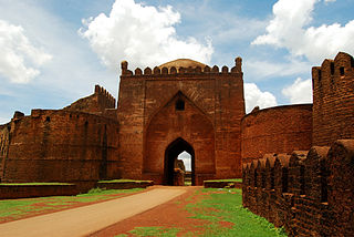
Bidar Fort is located in old city area, Bidar, Karnataka, India. The fort, the city and the district are all affixed with the name Bidar. Sultan Ahmad Shah I of the Bahmanid dynasty shifted his capital from Gulbarga to Bidar in 1427 and built his fort along with a number of Islamic monuments. There are over 30 monuments inside Bidar fort.
When Aurangzeb made Aurangabad his capital, there were 54 suburbs which were walled in like the city itself, but the chief of these that were populated in the 19th century were Begampura and Aurang-pura.

Neher water system provided clean water for the people of Aurangabad and its suburbs. It was created by Malik Ambar who founded the town under the name Khadki and was later expanded by Aurangzeb to facilitate the military activity that became prevalent under Mughal rule during the 17th century.

Salim Ali Lake is located near Delhi Gate, one of the many Gates in Aurangabad, opposite Himayat Bagh, Aurangabad. It is located in the northern part of the city. During the Mughal period, it was known as Khiziri Talab. It has been renamed after the great ornithologist, naturalist Salim Ali and also known as birdman of India. The office of Divisional Commissioner Aurangabad division is located near it, so is the collector's office of Aurangabad District.
Himayat Bagh Biodiversity Heritage site is a 17th-century garden that now houses the Fruit Research Station and Nursery, which is a part of the Vasantrao Naik Marathwada Krishi Vidyapeeth. It is located near Delhi Gate in Rauza Bagh area of Aurangabad, in the Indian state of Maharashtra. It is a sprawling complex spread over 300 acres (1.2 km2), naturally green and in the olden days it was known as the Mughal Garden.
The Jama Masjid is a mosque built in 1612 AD, located near the Killa Arrak in Aurangabad, Maharashtra, India. It is historically significant because it was constructed in 1612 AD, very soon after the foundation of Aurangabad by Malik Amber in 1610 AD. The mosque was later extended by Aurangzeb(R.H) in the year 1692 AD, it is one of the oldest mosques of Aurangabad which is still in good condition.
Qila-e-Ark is a 17th-century palace/citadel complex in Aurangabad, Maharashtra. Built by Mughal emperor Aurangzeb when he was a prince, it served as his royal residence during his subsequent reign as emperor. The site is currently ruined, and has no legal protected status; several modern-day buildings also encroach the complex. Notable surviving structures include a royal mosque, and a palatial building.