Gaya Island

Last updated

Gaya Island
KKMap3.png
A map of the west coast of Kota Kinabalu city and Gaya Island
Borneo Locator Topography.png
Red pog.svg
Gaya Island
Geography
Coordinates 6°1′5″N116°2′7″E / 6.01806°N 116.03528°E / 6.01806; 116.03528
Administration
State Flag of Sabah.svg  Sabah

Gaya Island (Malay : Pulau Gaya) is a sizeable Malaysian island of 1,465 ha, just 10 minutes off Kota Kinabalu, Sabah and forms part of the Tunku Abdul Rahman National Park. Gaya Island derived its name from the word "Gayo" which means big in both the Kadazandusun and Bajau [1] languages and occupies an area of 15 km2 (3,700 acres) with an elevation of up to 300 metres. Several ridges rise more than 600 feet (180 m), peaking at 1,000 feet (300 m), along the backbone of Gaya Island.

Contents

Gaya is the largest island in the Tunku Abdul Rahman National Park, closest to downtown Kota Kinabalu (KK) and is covered with dense virgin, tropical forest. It has been a forest reserve since 1923. The island has 20 km of hiking trails and three 5 star resorts named Gayana Marine Resort, home to the Marine Ecology Research Centre, the neighboring Gaya Island Resort (by YTL Hotel Group), the Bunga Raya Island Resort on the north-east part of the island. Historically, Gaya Island was also the site of the English colonialist's British North Borneo Company's harbour, razed by the folk hero Mat Salleh on 9 July 1897.

In recent years, there has been a plan to turn Gaya Island into a city island and tourism hub. [2] A cable car line has also been proposed before to connect with the city centre. [3]

History

Before the Ice Age, it formed part of the Crocker Range mass of sandstone and sedimentary rock on the mainland. However, about one million years ago, the melting ice brought about changes in the sea level and parts of the mainland were cut off by the sea to form the islands of Gaya Island, Sapi Island, Manukan Island, Mamutik Island and Sulug Island. Evidence of this can be seen from the exposed sandstone of the coastline forming the cliffs, caves, honeycombs and deep crevices.[ citation needed ]

In 1882, the North Borneo Chartered Company set up a trading settlement on Gaya Island. After destruction in 1898 the settlement was moved to the mainland in 1899 and named as Jesselton in honour of Charles Jessel, a manager of the Chartered Company. Later it was renamed to its current name, Kota Kinabalu.

In 1974, the major part of Gaya and Sapi islands was gazetted as Tunku Abdul Rahman National Park, covering an area of 8,990 acres (36.4 km2). In 1979, the park was increased to 12,185 acres (49.31 km2) with the inclusion of the three nearby islands of Manukan, Mamutik and Sulug. The park is spread over 4,929 hectares, two thirds of which cover the sea.

Illegal settlement

Kampung Pondo, with a huge colony of illegal immigrants house in Gaya Island. Pulau Gaya immigrant dwellings.jpg
Kampung Pondo, with a huge colony of illegal immigrants house in Gaya Island.

Starting from 1970s, Filipino-Moro refugees comprising Tausūg and Bajau peoples began to inhabit the island in their bid to escape from the war in the southern Philippines. [4] Both the Malaysian federal government and the Sabah state government do not officially recognise the settlement and the inhabitants as they are known as illegal immigrants. The eastern shore of Gaya Island supports a well-known illegal Filipino colony, called Kampung Lok Urai, with stilt houses girdling the beach as far as the eye can see. It has a 6,000 floating population of largely Filipinos who provide Kota Kinabalu with a source of cheap labour. It is considered a dangerous, high crime or "no-go" area by the police and KK-ian locals. The stilt houses are linked by walkways of weathered planks. As the population grew, new houses spread seaward, with no regard for sanitation. [4] The population in the island have also been criticised for their rubbish throwing attitude, where most of the rubbish will be found floating around the sea near their settlements. [5] Three fires in 1994, 1998 and in 2014 have wiped out nearly half of Kampung Pondo. [6]

The Sabah state government has since been working to end the Filipino squatter problems that have become the main cause for rampant crimes, terrorism and drug trafficking in the state, especially in the capital city, as their location is too close within business areas, by relocating these squatters to a proper place for proper management, [7] while many of the problematic, illegal immigrants will be deported back to the Philippines and their further entry will be prevented. [2] [8] After the fire in Kampung Pondo on 2014, the Sabah state government has proposed to move the illegal immigrants in the island to Kinarut with a better facility of modern houses. This proposal has been vehemently opposed by the Sabahan citizens, including some demands addressed to the current Chief Minister to resign for mishandling his power. [9] In late 2016, the state government submitted recommendations to the Malaysian federal government through the Main Committee on Management of Foreigners to move any refugee placement schemes in the state to other more suitable locations far from the towns and industrial development areas. [10]

The squatters relocation is in line with the Kota Kinabalu metropolitan development to turn Gaya Island into a city island and tourism hub. [2]

Administration

Sabah Parks, the body charged with protecting the Tunku Abdul Rahman Park, is headquartered on the south-eastern part of Gaya Island in a bay shared with the Downbelow Marine & Wildlife Adventures dive station. A development on the edge of Gaya island nearest to Sapi island is also used by Sabah Parks and offers a small, quiet beach for public recreational use.

Tourism

Panoramic photo of the island Gaya Island 2.jpg
Panoramic photo of the island

Gaya Island is well known for a legendary beach at Police Bay. The 400 metres (0.25 mile) stretch of white sand, gently slopes out to the sea and makes Police Beach ideal for swimming in the crystal clear water. Police Beach fronts the upmarket Bunga Raya Island Resort. The coral reefs along the entire coast of Gaya island are in excellent condition, making it a surprisingly good diving destination, considering its proximity to Kota Kinabalu city.

Transportation

Jetty used to go to Gaya Island Filipino village. Jetty to Gaya.jpg
Jetty used to go to Gaya Island Filipino village.

Jesselton Point Ferry Terminal in downtown Kota Kinabalu is the ferry terminal for those heading to the islands in Tunku Abdul Rahman National Park (Gaya Island, Sapi Island, Manukan Island, Mamutik Island and Sulug Island). This ferry terminal is also the departure point for patrons staying at either Manukan Island Resort or Gayana Resort. While the speedboat owners on the island are kept busy, ferrying Filipinos schoolchildren, housewives and traders who sell craftwork at the Filipino market in the Kota Kinabalu Waterfront.

See also

Related Research Articles

<span class="mw-page-title-main">Kota Kinabalu</span> State capital city and district capital in Sabah, Malaysia

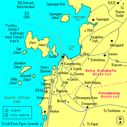
Kota Kinabalu, colloquially referred to as KK, is the state capital of Sabah, Malaysia. It is also the capital of the Kota Kinabalu District as well as the West Coast Division of Sabah. The city is located on the northwest coast of Borneo facing the South China Sea. The Tunku Abdul Rahman National Park lies to its west and Mount Kinabalu, which gave the city its name, is located to its east. Kota Kinabalu has a population of 452,058 according to the 2010 census; when the adjacent Penampang and Tuaran districts are included, the metro area has a combined population of 628,725. The 2020 Census revealed an increase in the municipal population to 500,421, while the wider area including the Penampang and Putatan districts had a population of 731,406.

Tiga Island is one of a group of small uninhabited volcanic islands in Kimanis Bay off the western coast of Sabah, Malaysia. The islands were formed on 21 September 1897, when an earthquake on Mindanao caused a volcanic eruption near Borneo. The island is 607 hectares in size and has a couple of active mud volcanos at the highest part of the island. Tiga Island is one of the three islands that make up Tiga Island National Park. The Park Headquarters are on the island, comprising an office complex, and accommodation for the park staff and visiting scientists.

<span class="mw-page-title-main">Sabah Parks</span>

Sabah Parks is a conservation-based statutory body established in 1964 with the purpose of conserving the scenic, scientific and historic heritage of the state of Sabah, Malaysia, on the island of Borneo. The organisation is also responsible for the management and promotion of the various protected reserves in Sabah, in particular those designated as national parks. It is also mandated to develop tourism-friendly facilities to accommodate tourist arrivals to these reserves and ensure that the state of the reserves is not compromised. The first choice for inclusion in a park system was Mount Kinabalu. As a result, Kinabalu Park was gazetted in 1964, and today it is designated as a World Heritage Site.

<span class="mw-page-title-main">Tunku Abdul Rahman National Park</span> National park in Malaysia

The Tunku Abdul Rahman National Park comprises a group of 5 islands located between 3 and 8 km off Kota Kinabalu in Sabah, Malaysia. The park is spread over 4,929 hectares, two-thirds of which cover the sea. Before the Ice age, it formed part of the Crocker Range mass of sandstone and sedimentary rock on the mainland. However, about one million years ago, the melting ice brought about changes in the sea level and parts of the mainland were cut off by the sea to form the islands of Gaya, Sapi, Manukan, Mamutik and Sulug. Evidence of this can be seen from the exposed sandstone of the coastline forming the cliffs, caves, honeycombs and deep crevices. The park was named after Tunku Abdul Rahman, Malaysia's first Prime Minister.

<span class="mw-page-title-main">Kapalai</span> Island in Malaysia

Kapalai is an island in Tawau Division, Sabah, Malaysia, known for its scuba resorts.

<span class="mw-page-title-main">Sabah Air</span> Malaysian airline

Sabah Air Aviation Sdn Bhd, trading as SabahAir, is a non-scheduled airline with its main base in the Sabah Air Building in Kota Kinabalu, Sabah, Malaysia.

<span class="mw-page-title-main">Manggatal</span> Place in Sabah, Malaysia

Menggatal or Manggatal is a Malaysian town and suburb of Kota Kinabalu District on the west coast of Sabah. It is an outskirt of the state capital, Kota Kinabalu, and is under the jurisdiction of Kota Kinabalu City Hall. It is located along Jalan Tuaran, which is the main road leading north from Kota Kinabalu city centre.

<span class="mw-page-title-main">Tourism in Malaysia</span> Overview of tourism in Malaysia

Tourism in Malaysia is a major industry and contributor to the Malaysian economy. Malaysia was once ranked 9th in the world for tourist arrivals. The Travel and Tourism Competitiveness Report 2017 ranks Malaysia 25th out of 141 countries overall.

Tanjung Aru is a sub-district of Kota Kinabalu in Sabah, of Malaysia. Its main feature is its beach called Tanjung Aru Beach which stretches to over 2 kilometres long along with new skyscrapers. This beach has a lot of Casuarina equisetifolia trees (aru) there naming this town.

<span class="mw-page-title-main">History of Sabah</span>

The history of Sabah can be traced back to about 23–30,000 years ago when evidence suggests the earliest human settlement in the region existed. The history is interwoven with the history of Brunei and the history of Malaysia, which Sabah was previously part of and is currently part of respectively. The earliest recorded history of Sabah being part of any organised civilisation began in the early 15th century during the thriving era of the Sultanate of Brunei. Prior to this, early inhabitants of the land lived in predominantly tribal societies, although such tribal societies had continued to exist until the 1900s. The eastern part of Sabah was ceded to the Sultan of Sulu by the Sultan of Brunei in 1658 for the former helping a victory over Brunei enemies, but many sources stated it had not been ceded at all. By the late 19th century, both territories previously owned by Sultan of Brunei and Sultan of Sulu was granted to British syndicate and later emerged as British North Borneo under the management of the North Borneo Chartered Company. Sabah became a protectorate of the United Kingdom in 1888 and subsequently became a Crown colony from 1946 until 1963, during which time it was known as Crown Colony of North Borneo. On 16 September 1963, Sabah merged with Malaya, Sarawak and Singapore to form Malaysia.

<span class="mw-page-title-main">Manukan Island</span> Island in Malaysia

Manukan Island is the second largest island in the Tunku Abdul Rahman National Park, Malaysia's first marine national park. It is located in the East Malaysian state of Sabah, just off the coast of Kota Kinabalu and is easily accessible by boat.

<span class="mw-page-title-main">Greater Kota Kinabalu</span> Metropolitan area in Sabah, Malaysia

Greater Kota Kinabalu refers to the dense clusters of regional populated areas surrounding the city of Kota Kinabalu in Malaysia. It comprises the districts of Kota Kinabalu, Penampang, Tuaran and Papar. These districts are also part of the West Coast Division. It was forecasted that in 2019, the combined population of these districts was 1.1 million people, in a combined area of 3,277 km2.

<span class="mw-page-title-main">Peter Joinud Mojuntin</span> Malaysian politician

Datuk Peter Joinod Mojuntin, PGDK was a politician in the Malaysian state of Sabah and Minister of Municipal Administration in the government of Tun Fuad Stephens. He died along with other politicians in the Double Six Plane Crash in Kota Kinabalu.

<span class="mw-page-title-main">Gaya Street, Kota Kinabalu</span>

The Gaya Street is a street Sunday market area in Kota Kinabalu, Sabah, Malaysia. It is known as the Chinatown of Sabah due to many Chinese coffee shops and restaurants situated there. In addition with an arch gate that was erected since 2005.

<span class="mw-page-title-main">Suria Sabah</span> Shopping mall in Kota Kinabalu, Sabah, Malaysia

Suria Sabah is a shopping centre located in the city of Kota Kinabalu, Sabah, Malaysia. Completed in July 2009, the mall sits on an 11-acre site facing the South China Sea with a scenic view of the Tunku Abdul Rahman National Park.

<span class="mw-page-title-main">Sutera Harbour</span> Harbour in Kota Kinabalu, Sabah, Malaysia

Sutera Harbour is a resort located in the city of Kota Kinabalu, Sabah, Malaysia. It comprised two 5-star hotels, a 27-hole Graham Marsh-designed golf course, a 104-berth marina and an exclusive golf and country club with extensive recreational facilities facing the South China Sea with a background of Tunku Abdul Rahman National Park. In 2014, Singapore-based GSH Corporation has acquired the resort.

<span class="mw-page-title-main">Penampang District</span> District of Malaysia in Sabah

The Penampang District is an administrative district in the Malaysian state of Sabah, part of the West Coast Division which includes the districts of Kota Belud, Kota Kinabalu, Papar, Penampang, Putatan, Ranau and Tuaran. The capital of the district is in Penampang Town.

Abdul Ghani bin Gilong was a Malaysian politician. He was a federal cabinet minister in various portfolios from 1968 to 1978.

References

  1. ""Gayo" in Kadazandusun" . Retrieved 5 May 2024.
  2. 1 2 3 "Master Plan for touristic Pulau Gaya being drawn up". Daily Express. 11 July 2013. Retrieved 2 December 2016.
  3. "Chamber proposes KK-Gaya Island cable car link". The Borneo Post. 28 February 2014. Retrieved 2 December 2016.
  4. 1 2 Paul J. Carnegie; Victor T. King; Zawawi Ibrahim (21 September 2016). Human Insecurities in Southeast Asia. Springer. pp. 77–. ISBN   978-981-10-2245-6.
  5. "Gaya Island's image tarnished by rubbish dumping into sea". Daily Express. 15 June 2015. Retrieved 2 December 2016.
  6. Stephanie Lee (3 July 2014). "Kebakaran Di Pulau Gaya: Letupan Kedengaran, Belasan Rumah Musnah" (in Malay). mStar. Retrieved 7 July 2014.
  7. Muguntan Vanar (16 February 2016). "Sabah aims to end squatter problem". The Star. Retrieved 2 December 2016.
  8. Pia Ranada (11 November 2016). "PH, Malaysia agree on repatriation of Filipinos in Sabah". Rappler. Retrieved 2 December 2016.
  9. Sean Agustin (6 July 2014). "Facebook campaign to remove Sabah CM over illegal immigrant issue". The Rakyat Post. Archived from the original on 4 March 2016. Retrieved 7 July 2014.
  10. "Sabah government to submit recommendations to move refugee placement schemes". Bernama. The Sun. 24 November 2016. Archived from the original on 8 April 2017. Retrieved 2 December 2016.

Further reading